Lincoln County lies in north-central Kansas, where the Saline River cuts through the Smoky Hills and the county seat sits close to the middle of the road network. The map labels the main city as Lincoln Center, with Sylvan Grove, Beverly, and Barnard providing smaller references around the county. K-18 crosses the central area, K-14 runs north-south through Lincoln Center, and K-181, K-232, and K-284 connect the western and northern countryside. High-resolution JPG versions of the maps can be downloaded together from the ZIP box below. High-resolution map files are available for download in the section below.
The Saline River is the dominant physical feature. It enters from the west, bends through the middle of the county, and continues east past the Lincoln Center–Beverly area. Spillman Creek, Rattlesnake Creek, Prairie Creek, Bullfoot Creek, Spring Creek, and the Elkhorn Creek branches divide the surrounding hills into many narrow valleys. Elevation ranges from about 391 to 559 meters with a mean near 459 meters.
Lincoln County was established in 1867 and organized in 1870. The Kansas Historical Society records Lincoln as the county seat after an 1872 election, while the city’s official website still uses the historic name Lincoln Center. The community is also known as the Post Rock Capital of Kansas, a reference to the limestone fence posts and stone buildings that are closely tied to the county’s Smoky Hills landscape.
Table of Contents
Lincoln Center marks the K-18 and K-14 crossroads
Lincoln Center sits slightly east of the county’s geographic middle and provides the easiest road reference. K-18 runs west from the Sylvan Grove side, passes through Lincoln Center, and continues toward Beverly and the eastern county. K-14 crosses it north-south and links the county seat with areas toward Mitchell County on the north and Ellsworth County on the south.
Sylvan Grove lies west of Lincoln Center and connects with K-181 and K-232. Beverly is east of the county seat on the K-18 corridor and sits close to the Saline River lowland. Barnard lies in the northeast near K-284, making it a useful reference for the northern uplands.
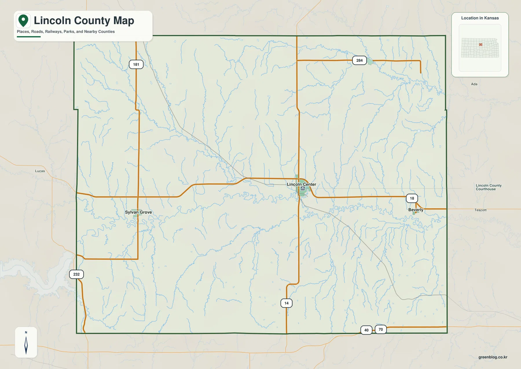
The map also shows nearby places outside the county, including Lucas, Tescott, and Ada. They help orient the county within north-central Kansas but should not be confused with Lincoln County communities. For actual travel, current road construction, winter weather, and unpaved-road conditions should be checked separately.
Four small cities are spread across the county
The city map ranks Lincoln Center first, Sylvan Grove second, Beverly third, and Barnard fourth. The displayed source values are 1,017 for Lincoln Center, 314 for Sylvan Grove, 132 for Beverly, and 97 for Barnard. Those figures may differ from later estimates, but they clearly show the county’s strongly rural settlement pattern.
The map also gives direct distances from Lincoln Center: about 13 miles to Sylvan Grove, 9 miles to Beverly, and 11 miles to Barnard. These are straight-line measurements rather than driving distances, so road mileage and travel time will be longer or different depending on the route.
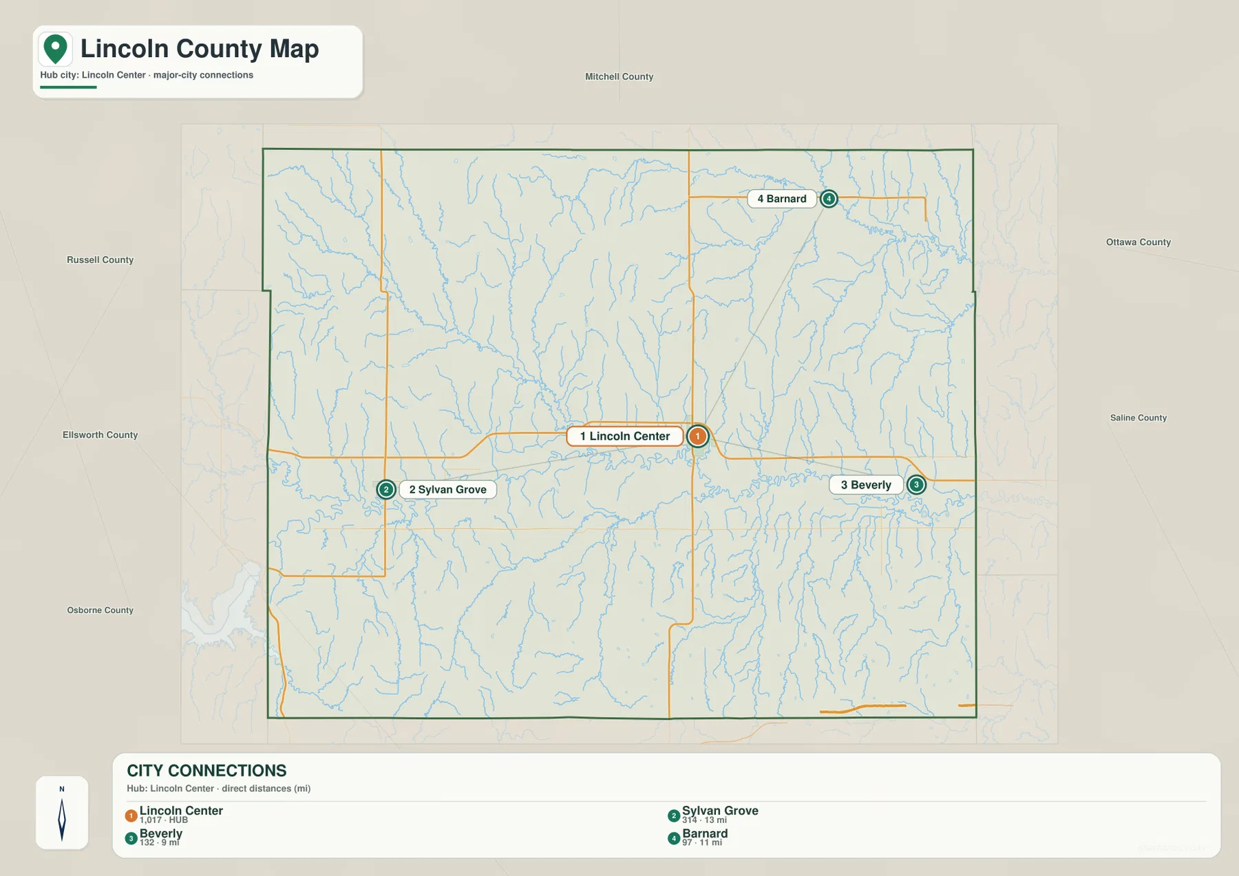
The naming can be slightly confusing. The map and current city website use Lincoln Center, while the Kansas Historical Society commonly uses Lincoln for the county seat. Both names refer to the same community, which began as Lincoln Center during the county-seat contest of the early 1870s.
The Saline River forms the county’s central lowland
The Saline River crosses the county from west to east in a broad, winding corridor. It passes south of Sylvan Grove and Lincoln Center before continuing toward Beverly and the eastern boundary. Because it occupies the main lowland through the middle of the county, the river is a useful reference for both settlement and terrain.
North of the river, Beaver Creek and Spillman Creek descend from the northwest, while Rattlesnake Creek runs across the northern uplands. Prairie Creek, West Elkhorn Creek, and Salt Creek add more valleys in the northeast. These tributaries cut deeply into the rolling surface before reaching larger drainage routes.
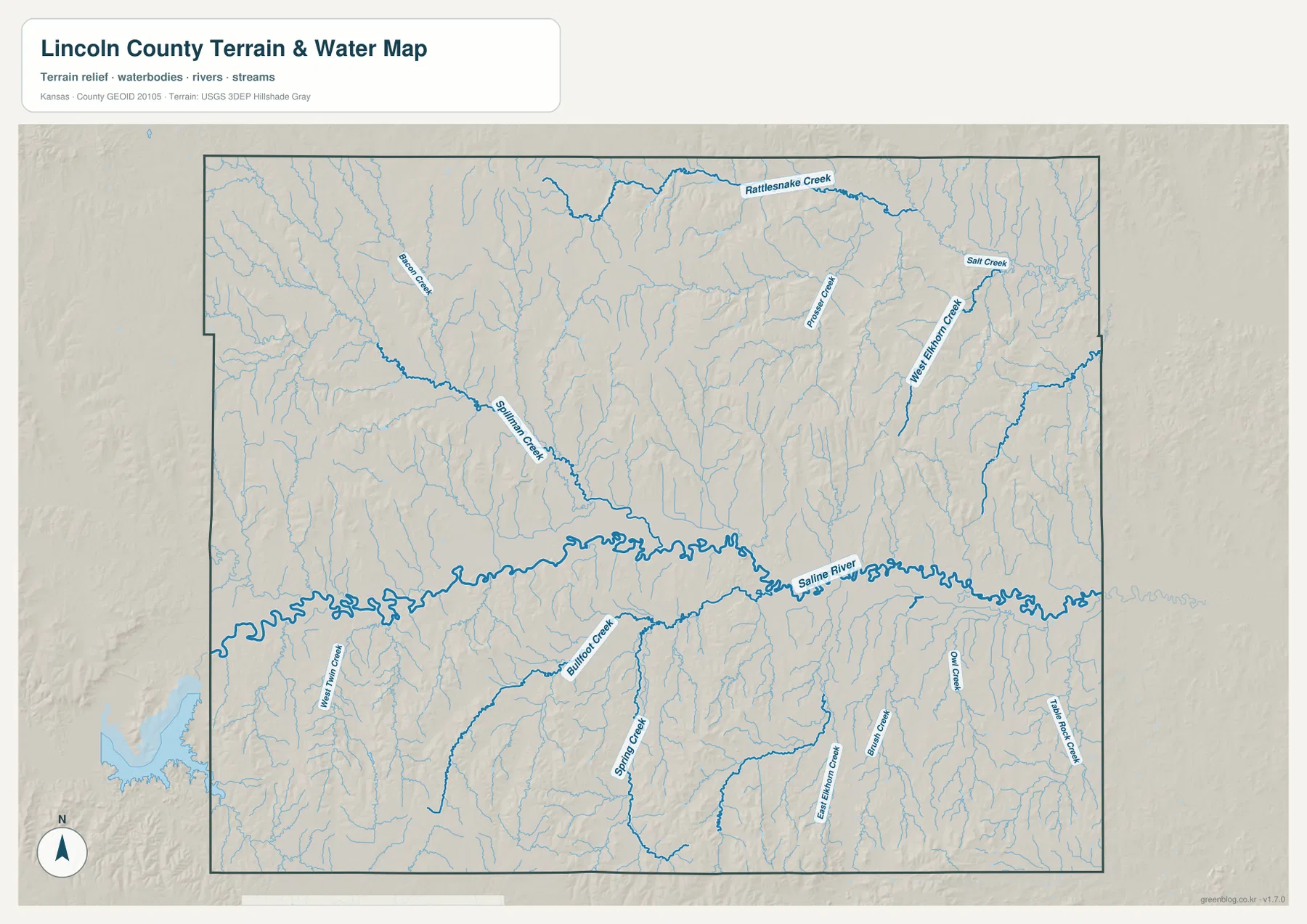
South of the Saline River, West Twin Creek, Bullfoot Creek, Spring Creek, East Elkhorn Creek, Drum Creek, Owl Creek, and Table Rock Creek create another dense set of valleys. The map is intended to show the position of rivers and streams, not live streamflow, flood risk, or water quality.
Elevation rises sharply away from the Saline River
Lincoln County ranges from approximately 391 to 559 meters in elevation and averages near 459 meters. The Saline River corridor appears as a long green band through the center, and lower terrain extends into the northeastern part of the county. Higher orange and brown ground covers much of the west and southwest.
The contrast is especially strong south of the river. Bullfoot Creek, Spring Creek, and the Elkhorn Creek branches cut narrow low valleys between higher ridges, while the southwestern edge contains some of the county’s highest terrain. North of the river, Spillman Creek and other tributaries also create sharp local relief.
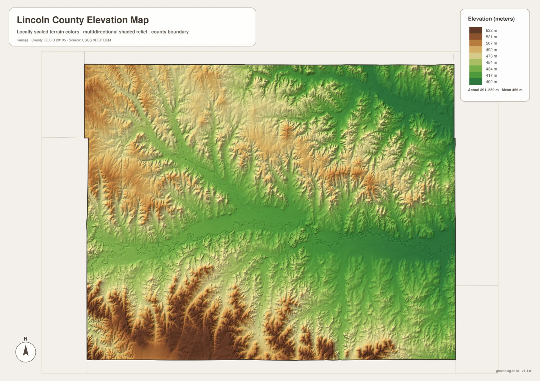
This surface is designed for county-scale comparison rather than survey work. It should not be used to establish exact parcel elevations, engineering grades, drainage design, or legal boundaries. Its strength is showing how quickly the land rises from the river bottom into the surrounding hills.
How Lincoln Center became the county seat
Lincoln County was established in 1867, organized in 1870, and named for President Abraham Lincoln. The Kansas Historical Society records that Abram initially served as the county seat. After an 1872 election, Lincoln Center won the contest and became the permanent administrative center.
The word Center was chosen in part because the town’s promoters wanted to emphasize its central position in the county. The present road map still supports that idea: K-18 and K-14 meet there, and the city is positioned between the western, northern, and eastern rural communities.
The current courthouse was completed in 1900 after an earlier courthouse burned. It is one of several historic stone buildings that connect the city with the local limestone landscape. The Kansas Historical Society also documents the Lincoln Carnegie Library and rock-art sites elsewhere in the county.
Why Lincoln is called the Post Rock Capital of Kansas
The official City of Lincoln Center website describes Lincoln as the Post Rock Capital of Kansas. Early settlers had limited access to large timber, so they cut local limestone into durable fence posts and building stone. Those stone posts became one of the most recognizable features of the surrounding countryside.
The geology is visible in the landscape as well as the architecture. The Saline River occupies a lower central valley, while rocky hills and ridges rise on both sides, especially toward the south and west. The courthouse and other downtown buildings use local stone, giving the city a direct visual connection with the surrounding Smoky Hills.
This is why the elevation and water maps add useful context to the road map. They show that the county’s historic building material, farm boundaries, and settlement pattern developed within a landscape of limestone ridges, narrow creek valleys, and the broad Saline River corridor.
Spillman Creek and the county’s difficult early settlement years
Kansas Historical Society accounts describe violence in Lincoln County and nearby areas during the late 1860s as settlers, Native peoples, and the U.S. military came into conflict during westward expansion. A detachment of the 7th U.S. Cavalry was stationed in the county in 1868, and historical events were recorded near Lincoln Center, Spillman Creek, and other parts of the Saline River country.
Today Spillman Creek appears on the map as a quiet tributary entering the Saline River from the northwest. Historical records give the same place a much heavier meaning, showing how natural landmarks often become the geographic setting for events that shaped local memory.
The history is best approached with attention to the experiences of all groups involved. The map itself is a modern geographic reference, but it can help readers locate the river and creek valleys mentioned in historical sources without turning the landscape into a simplified account of the conflict.
Using the maps for printing and county study
For road orientation, start with Lincoln Center and follow K-18 west toward Sylvan Grove and east toward Beverly, then use K-14 as the main north-south reference. For physical geography, trace the Saline River first and compare Spillman Creek, Rattlesnake Creek, Bullfoot Creek, and the Elkhorn Creek branches on either side.
The high-resolution JPG files in the ZIP are better suited than the reduced web previews for printing, classroom projects, Post Rock history, and close inspection of road and water labels. Current road conditions, live stream information, parcel boundaries, and exact elevations should always be checked with the latest authoritative sources when those details matter.
Frequently Asked Questions
Are Lincoln Center and Lincoln the same place?
Yes. The map and the current city website use Lincoln Center, while the Kansas Historical Society commonly uses Lincoln for the county seat. Both names refer to the same community at the K-18 and K-14 crossroads.
Where does the Saline River cross Lincoln County?
The Saline River runs from west to east through the center of the county. It passes south of Sylvan Grove and Lincoln Center and continues through the Beverly area, forming the county’s broadest continuous lowland.
Can the 391–559 meter elevation map be used for surveying?
No. The elevation map is a county-scale reference for comparing hills and river valleys. Exact parcel elevations, construction design, drainage engineering, and legal surveys require purpose-built data and professional methods.
Map File Information
Download the high-resolution JPG files corresponding to the Lincoln County general, city distribution, terrain-and-water, and elevation maps in one ZIP archive.
- Included Files: Use only the versions confirmed in the article and supplied images
- File Type: Use the confirmed download contents
- Intended Use: Printing, education, presentations, and map-based projects
Related Maps
Sources and references
- City of Lincoln Center — K-14/K-18 location, Post Rock Capital history, local limestone buildings, and city information
- Kansas Historical Society — Lincoln County, Kansas — establishment, organization, county-seat history, courthouse, and local historical context
- U.S. Census Bureau QuickFacts — Lincoln County, Kansas — county population context
- U.S. Census Bureau TIGER/Line — boundary, road, and geographic data resources
- USGS National Hydrography — hydrography and stream-network data information
- USGS 3D Elevation Program — elevation data information
Green Map creates custom-edited map images using open geographic data sources such as geoBoundaries, Natural Earth, OpenStreetMap, and government open data.
These maps are edited visual materials, not raw data files, and are provided for education, documents, presentations, and graphic reference.