Hamilton County lies on the western edge of Kansas, where Syracuse and the Arkansas River provide the clearest framework for understanding settlements, roads, drainage, and the High Plains surface. Syracuse is the county seat and largest city, while Coolidge is a much smaller community near the Colorado line. U.S. 50 and U.S. 400 follow the Arkansas River corridor across the county. High-resolution JPG versions of the maps shown on this page can be downloaded together from the ZIP box below. High-resolution map files are available for download in the section below.
The landscape combines elevated High Plains with the lower Arkansas River valley. The elevation map ranges from about 952 to 1,173 meters and gives a mean near 1,052 meters. Higher terrain dominates much of the west and northwest, while the river corridor and eastern side lie lower. East Bridge Creek, West Bridge Creek, Syracuse Creek, Sand Creek, Shirley Creek, and several named ditches cut into the broad uplands around the main river.
The Kansas Historical Society describes Hamilton County as part of the Santa Fe Trail corridor and identifies Syracuse as the county seat. Fort Aubry was established in 1865 to protect commerce along the route, and later the Atchison, Topeka and Santa Fe Railway served Syracuse, Kendall, and Coolidge. The modern map still concentrates settlement and transportation along the Arkansas River, making the historic east-west corridor easy to recognize.
Table of Contents
Syracuse and the U.S. 50–U.S. 400 corridor
Syracuse is the most useful first reference on the general county map. The Hamilton County Courthouse is labeled inside the community, and U.S. 50 and U.S. 400 run nearby from west to east. Those highways continue toward Coolidge and Colorado on one side and toward Kearny County on the other, closely paralleling the Arkansas River corridor.
Coolidge sits near the western boundary, while Medway and Kendall provide smaller references along or near the same broad transportation zone. North and south of this corridor, long rural roads cross very sparsely settled agricultural land. The southeastern county boundary also contains a noticeable step rather than forming a perfect rectangle.
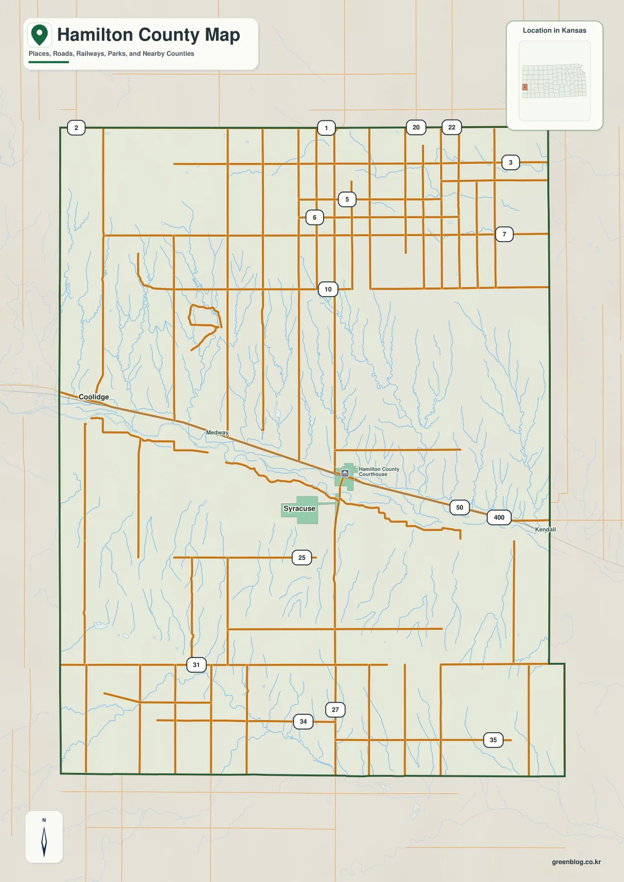
The road pattern looks highly regular across the uplands, but drainage valleys interrupt the grid near the river and its tributaries. Numerous creeks descend from the north, and smaller channels also cut the southern landscape. This map is intended for county-scale orientation rather than live navigation, so construction, unpaved-road conditions, high winds, and winter travel issues should be checked with current transportation sources.
Syracuse and Coolidge in the county’s city distribution
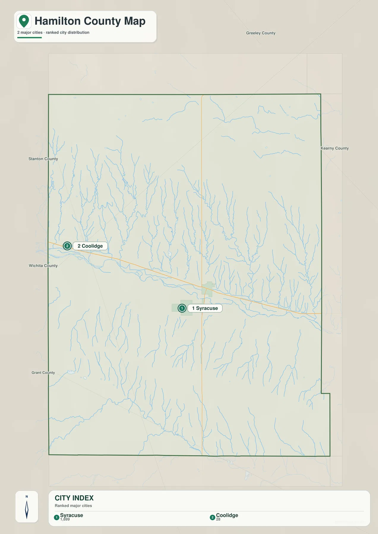
The city distribution map ranks Syracuse first and Coolidge second. Syracuse is labeled with a population of 1,699 and Coolidge with 28, values that reflect the dataset used to create the map rather than a permanent count. The durable geographic point is the enormous difference in settlement scale: county services and urban activity are heavily concentrated in Syracuse.
Both communities sit close to the Arkansas River and the U.S. 50/U.S. 400 corridor. Coolidge functions as a small western reference near the Colorado line, while Syracuse occupies a more central position and serves as the county’s administrative hub. Wide rural spaces separate them, with small places such as Medway providing additional orientation along the route.
The Kansas Historical Society records that Syracuse became the county seat after a disputed election in the 1880s. Kendall challenged the results, and the disagreement eventually reached the Kansas Supreme Court before Syracuse’s status was settled. The modern concentration of the courthouse and largest city at Syracuse reflects the outcome of that early county history.
Arkansas River, Bridge Creek, and the network of small channels
The terrain and water map is dominated by the Arkansas River, which crosses Hamilton County from west to east through a broad low corridor. The river passes the Coolidge–Syracuse transportation zone and continues toward the eastern boundary. Numerous tributaries descend from the higher country, giving the north side of the valley a particularly dense pattern of narrow drainages.
Cheyenne Creek and Spring Creek appear in the northwest. West Bridge Creek and East Bridge Creek form two prominent northern valleys, while Flume Creek, Syracuse Creek, and Sand Creek cut across the central and eastern uplands. Shirley Creek follows the far eastern side. Together these waterways reveal far more local relief than the simple agricultural road grid suggests.
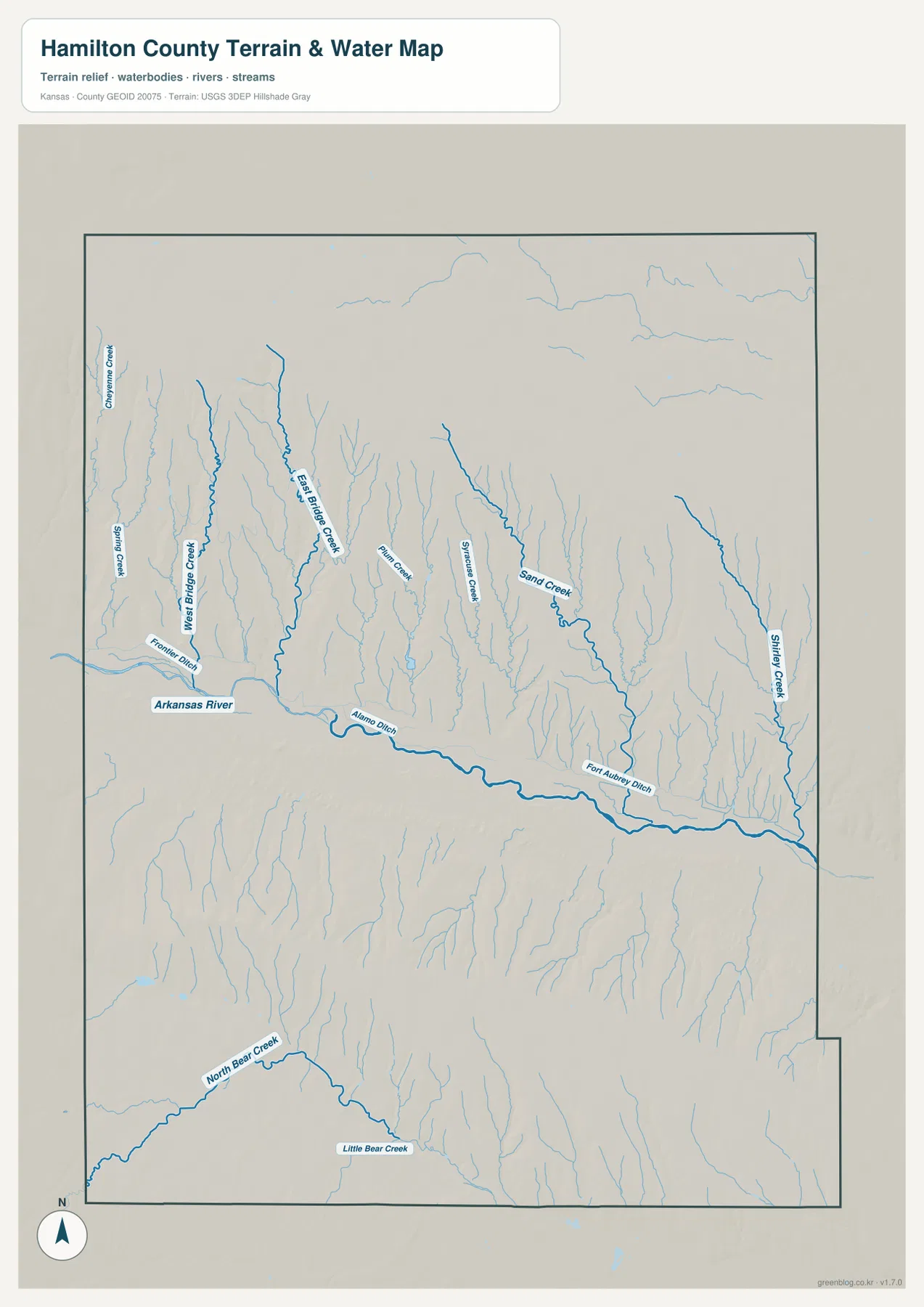
Frontier Ditch, Alamo Ditch, and Fort Aubry Ditch are also labeled near the main river corridor. Farther south, North Bear Creek and Little Bear Creek create separate drainage lines across the lower part of the county. The map is a geographic reference rather than a live hydrology product, so current streamflow, flood conditions, or water quality should be checked with USGS or responsible local agencies.
A 952–1,173 meter transition from western uplands to the river lowland
The elevation map shows an actual county range of approximately 952 to 1,173 meters and a mean elevation near 1,052 meters. Brown and orange colors dominate much of the western and northwestern county, while yellow-green and green become increasingly common toward the Arkansas River and the east. The broad surface therefore declines substantially across the county.
The Arkansas River creates the widest low green band through the middle of that slope. Bridge Creek, Sand Creek, Shirley Creek, and other tributaries form narrow green fingers extending back into the uplands. The western plains remain high, but the dense tributary network shows that they are cut by many shallow to moderate valleys rather than forming a featureless flat surface.
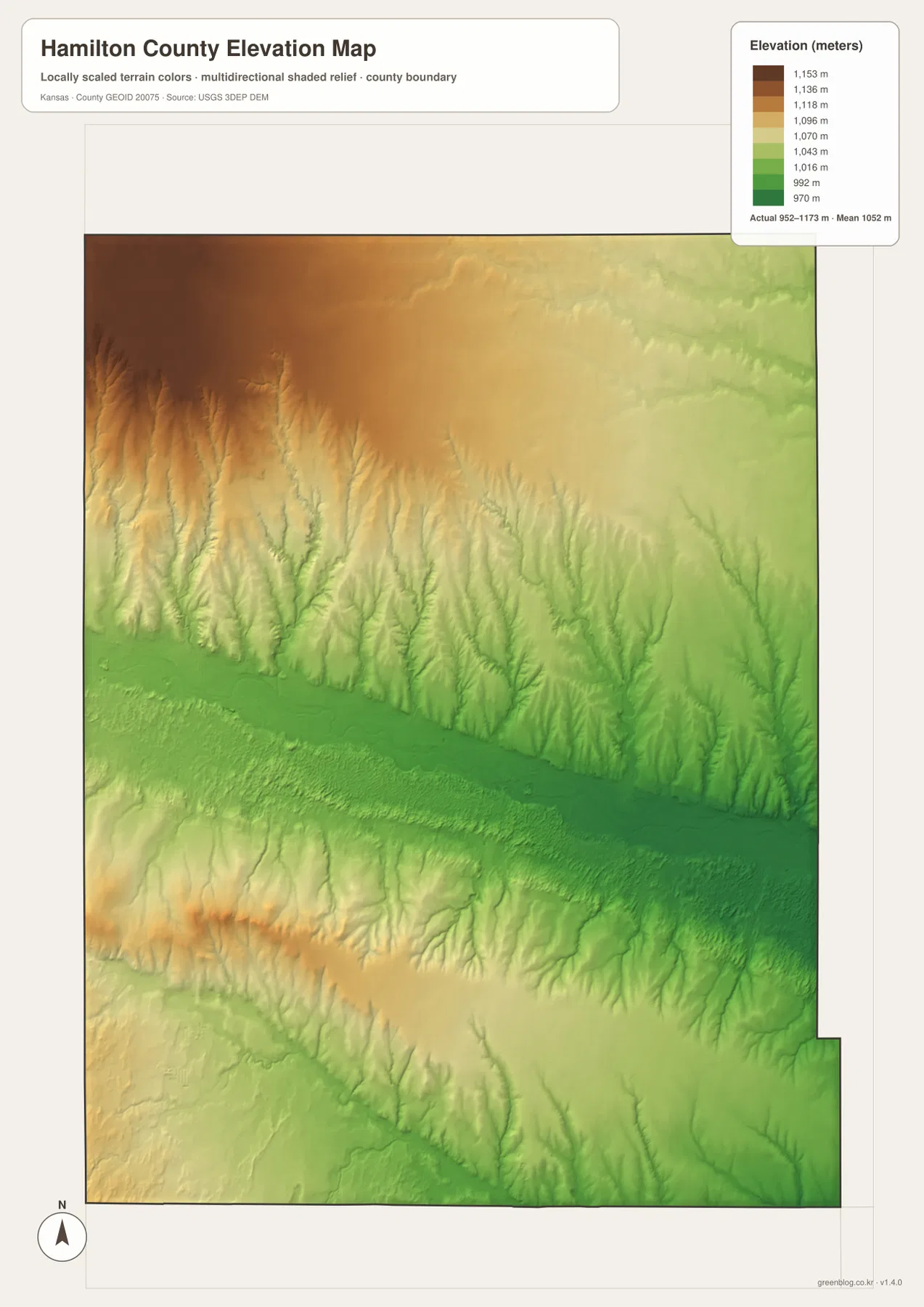
This elevation surface is intended for county-scale comparison rather than survey-grade measurement. It should not be used to establish exact parcel elevations, design drainage, or replace engineering and legal survey data. Its value is visual context: the Syracuse and Arkansas River corridor is clearly lower than much of the western county, with roughly 220 meters separating the mapped minimum and maximum elevations.
Santa Fe Trail, Fort Aubry, and the county-seat story
Hamilton County occupies a historic western transportation corridor. The Kansas Historical Society explains that the Santa Fe Trail passed through what are now Kendall, Syracuse, and Coolidge before continuing toward Colorado. The Atchison, Topeka and Santa Fe Railway later followed the same general east-west setting, reinforcing the importance of the Arkansas River valley for movement across the High Plains.
Fort Aubry was established in 1865 to protect commerce along the route. It operated only briefly, but its name remains part of the county’s historical landscape, including the Fort Aubry Ditch label visible on the water map. Coolidge also became a railroad division point before later changes shifted activity toward Syracuse and farther west.
The county-seat dispute between Syracuse and Kendall added another chapter to local history. After accusations of election fraud, another vote and court proceedings followed, and Syracuse ultimately remained the county seat. Hamilton County was also among the western Kansas areas severely affected by Dust Bowl wind erosion during the 1930s, a reminder of the environmental challenges faced on these open plains.
Using the maps for printing, study, and county orientation
For basic orientation, begin with Syracuse and follow U.S. 50/U.S. 400 west toward Coolidge or east toward Kendall and Kearny County. For physical geography, trace the Arkansas River and then compare the Bridge Creek system, Syracuse Creek, Sand Creek, and Shirley Creek. The elevation view explains why the main transportation corridor lies in a broad lowland beneath the higher western plains.
The high-resolution JPG files in the ZIP are better suited than the reduced web previews for printing, classroom projects, Santa Fe Trail history materials, and close inspection of labels. They are useful for county overviews and regional comparison, but current roads, live stream conditions, parcel boundaries, and exact elevations should always be checked against the latest authoritative sources when those details matter.
Frequently Asked Questions
Where is Syracuse on the Hamilton County map?
Syracuse sits slightly south of the county center and serves as the county seat and largest community. U.S. 50 and U.S. 400 run close to the Arkansas River through the area, making Syracuse the easiest first reference for county orientation.
Why is the Arkansas River important to Hamilton County geography?
The Arkansas River forms the county’s largest continuous low corridor and carries the principal east-west transportation zone near Syracuse and Coolidge. Numerous creeks and named ditches connect with or lie close to this lowland, and the elevation map shows it well below much of the western High Plains.
Can the 952–1,173 meter elevation map be used for surveying?
No. The elevation map is a county-scale visual reference for comparing uplands and valleys. Exact parcel elevations, construction design, drainage engineering, and legal surveys require purpose-built data and professional methods appropriate to those tasks.
Map File Information
Download the high-resolution JPG files corresponding to the Hamilton County general, city distribution, terrain-and-water, and elevation maps in one ZIP archive.
- Included Files: Use only the versions confirmed in the article and supplied images
- File Type: Use the confirmed download contents
- Intended Use: Printing, education, presentations, and map-based projects
Related Maps
Sources and references
- Hamilton County, Kansas official website — county government and Syracuse information
- Kansas Historical Society — Hamilton County, Kansas — Syracuse, Fort Aubry, Santa Fe Trail, county-seat history, and regional context
- U.S. Census Bureau TIGER/Line — boundary, road, and geographic data resources
- USGS National Hydrography — hydrography and stream-network data information
- USGS 3D Elevation Program — elevation data information
Green Map creates custom-edited map images using open geographic data sources such as geoBoundaries, Natural Earth, OpenStreetMap, and government open data.
These maps are edited visual materials, not raw data files, and are provided for education, documents, presentations, and graphic reference.