Dickinson County in north-central Kansas is easiest to understand by starting with Abilene. The city sits near Interstate 70 and U.S. 40, with K-15 providing a strong north-south reference through the central-western part of the county. Chapman and Enterprise lie to the east, Solomon marks the western edge, and Hope and Herington provide southern reference points. The maps on this page separate road and settlement context from drainage and elevation, and matching high-resolution JPG files can be downloaded together from the ZIP box later on the page. High-resolution map files are available for download in the section below.
The county’s physical shape becomes much clearer when Smoky Hill River is added to the picture. The river crosses the middle of Dickinson County in a broad low corridor, while higher terrain rises to the northwest and across much of the south. Chapman Creek, Turkey Creek, Carry Creek, Lyon Creek, and many smaller tributaries cut additional valleys into those uplands. The elevation surface spans approximately 327 to 482 meters, with a mean of about 386 meters, so the contrast between the river lowland and surrounding ridges is substantial.
Dickinson County’s official website notes that the county lies along Interstate 70, while the Kansas Historical Society identifies Abilene as the county seat and places the county in the Smoky Hills physiographic region. Those facts match the supplied maps well. Abilene sits in a major transportation position, the Smoky Hill River defines a long central lowland, and the ridge-and-valley pattern becomes increasingly obvious toward the northwest and south.
Table of Contents
Abilene and Interstate 70 as the first orientation line
The general county map makes Abilene the most practical first reference point. Interstate 70 and U.S. 40 establish an east-west corridor, while K-15 extends south from the city toward the Carlton area. Talmage and Manchester sit north of Abilene, and Detroit and Enterprise appear to the east and southeast. Once these places are located, the large rural sections between them become easier to read without memorizing every numbered road.
The eastern half contains a mix of roads and winding drainage. Chapman is a strong reference near the eastern side, while the southeastern corner is organized around Herington and state routes such as K-4, K-218, and K-56. Hope provides a useful southern interior reference, and Navarre sits between Enterprise and the southern part of the county. The map is intended for county-scale orientation rather than live navigation, so current construction, closures, and driving conditions should be checked with an up-to-date transportation source.
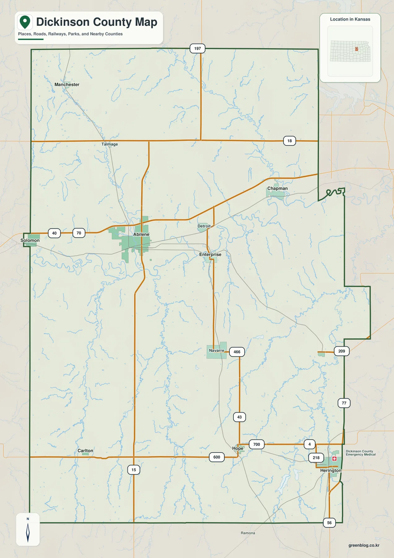
Solomon at the western edge and Abilene near the center-west make the I-70 and U.S. 40 corridor easy to follow. In the north, place labels are more widely spaced and roads such as K-18 and K-197 become important reference lines. The southwest is dominated by rural roads and smaller communities, while the southeast has a different pattern around Herington and Lake Herington. These differences show that road and settlement density changes noticeably within the county rather than forming one continuous urban corridor.
What the supplied city distribution map says about settlement
The city distribution map highlights six settlements and ranks the values printed on the map. Abilene is shown at 6,449, followed by Chapman at 1,454, Solomon at 892, Enterprise at 710, Hope at 485, and Woodbine at 137. These numbers are useful for understanding the hierarchy presented by this particular map. Anyone needing the latest official population estimate should consult current Census data rather than treating a static map label as a live statistic.
The spatial distribution matters as much as the ranking. Solomon sits on the western edge, Abilene occupies the central-western corridor, Chapman lies to the east, and Enterprise is southeast of Abilene. Hope is farther south, while Woodbine appears in the southeastern interior. The general county map separately shows Herington near the southeast edge. Together, these views portray a county made up of multiple small communities separated by large rural areas rather than one uninterrupted built-up zone.
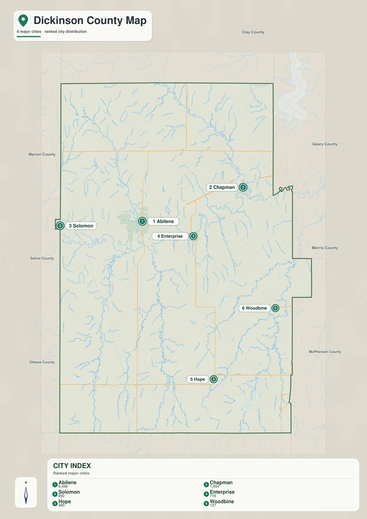
The settlement map becomes more informative when paired mentally with the road network. Abilene sits on the interstate corridor, Chapman is associated with the eastern drainage country, and Enterprise lies close to the Smoky Hill River system. Hope provides a reference for the southern rural area. Connecting each place to roads and landforms makes the county easier to remember than treating the ranking as a list of disconnected numbers.
Smoky Hill River as the central low corridor
The terrain and water map is dominated by Smoky Hill River. It enters from the west, bends through the middle of Dickinson County, and continues eastward through a broad low valley south of Abilene and north of Enterprise. Farther east the river makes larger bends before leaving the county. This central corridor is also the darkest green area on the elevation map, showing how closely the drainage and relief patterns correspond.
Chapman Creek descends from the north and joins the lower eastern part of the county, while Mud Creek marks a northwestern drainage. From the south, Turkey Creek and West Branch Turkey Creek form a long branching valley. Carry Creek and Lyon Creek create additional southeastern corridors, and Holland Creek with West Branch Holland Creek helps organize the southwest. The stream network is therefore distributed across the county rather than concentrated along a single tributary.
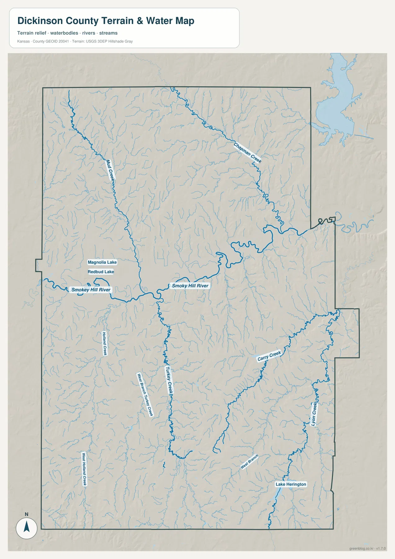
Magnolia Lake and Redbud Lake are labeled north of the Smoky Hill River in the central-western area, and Lake Herington appears in the southeast. These water features provide additional location references, but the map is not a flood-hazard, real-time streamflow, navigation, or water-quality product. Current river conditions should be checked with USGS or the appropriate local authority when timing and safety matter.
A 327–482 meter relief pattern shaped by the Smoky Hills
The elevation map shows an actual county range of roughly 327 to 482 meters and a mean of about 386 meters. The lowest green terrain follows Smoky Hill River in a broad band from west to east. Another pronounced low corridor follows the Chapman Creek system in the northeast. These valleys separate higher ground into large upland blocks and explain why the county looks much more textured on the relief map than on a simple road map.
Higher brown and orange terrain is extensive in the northwest and appears again across the southern and southeastern parts of the county. In the south, narrow valleys divide the high ground into repeated ridges rather than leaving one smooth plateau. The contrast is especially strong where tributaries cut toward Smoky Hill River or toward the southeastern drainage. This is a landscape of rolling uplands and incised valleys rather than isolated mountains.
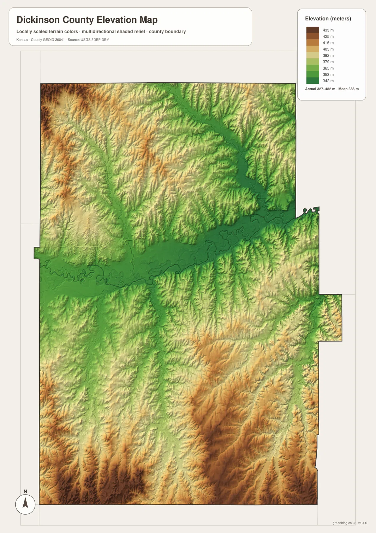
The Kansas Historical Society classifies Dickinson County in the Smoky Hills physiographic region, a useful context for reading the map. The ridge-and-valley pattern, the long river corridor, and the dissected southern terrain all fit that regional setting. The elevation surface is a county-scale reference, not a survey-grade product. Exact parcel elevation, engineering design, drainage planning, and legal surveys require purpose-built data and professional methods.
Why Abilene matters beyond road orientation
Abilene is not only the modern county seat; it also has an important place in Kansas history. The Kansas Historical Society describes the city as a major cowtown during the cattle-drive era, when livestock were brought to rail connections for shipment east. On the modern map, Abilene remains a strong transportation anchor near Interstate 70, U.S. 40, and K-15. Looking at history and current geography together helps explain why the city became the county’s most prominent reference point.
The rest of Dickinson County is not simply an extension of Abilene. Chapman, Enterprise, Hope, Woodbine, Solomon, and the southeastern Herington area sit in different combinations of roads, creek valleys, and uplands. Chapman is associated with the eastern drainage system, Enterprise lies near the Smoky Hill River corridor, and southern communities occupy more dissected terrain. Moving among the general, water, and elevation maps reveals these local differences far better than a single layer can.
Choosing the map that fits the question
For basic orientation, begin with the general map and locate Abilene at the I-70 and U.S. 40 corridor. Add Chapman, Enterprise, Solomon, and Hope to build a mental framework for the rest of the county. If the question is about physical geography, follow Smoky Hill River across the terrain-and-water map and then compare the same corridor on the elevation map. Chapman Creek and Turkey Creek are useful secondary references because they show how northern and southern tributaries connect with lower ground.
For printing, classroom work, local-history material, or a larger reference document, the high-resolution JPG files in the ZIP are preferable to reduced web previews. They make road labels, stream names, and terrain colors easier to inspect at larger sizes. Anyone republishing or modifying the maps should review relevant source and attribution requirements. Projects that depend on current roads, live water conditions, or exact elevations should combine these reference maps with the latest authoritative data.
Frequently Asked Questions
Why is Abilene the best first reference on the Dickinson County map?
Abilene is the county seat and sits near Interstate 70, U.S. 40, and K-15, making it the clearest road anchor for the county. It is also the largest settlement highlighted on the supplied city distribution map. From Abilene, Chapman, Enterprise, Solomon, Hope, and other communities can be placed quickly in relation to major routes and the Smoky Hill River corridor.
How does Smoky Hill River shape the county’s terrain?
Smoky Hill River forms a broad low corridor through the middle of Dickinson County. The elevation map shows this corridor in dark green, while Chapman Creek, Turkey Creek, Carry Creek, and other tributaries connect surrounding uplands to lower ground. Higher terrain rises to the northwest and across much of the south, so the river lowland becomes the major dividing feature in the county’s relief.
Can the 327–482 meter elevation map be used for surveying or engineering?
No. The elevation map is a county-scale visual reference for comparing ridges, valleys, and broad relief. Exact parcel elevations, construction design, drainage engineering, and legal surveys require more precise data and professional methods suited to those tasks.
Map File Information
Download the high-resolution JPG files corresponding to the Dickinson County general, city-distribution, terrain-and-water, and elevation maps in one ZIP archive.
- Included Files: Use only the versions confirmed in the article and supplied images
- File Type: Use the confirmed download contents
- Intended Use: Printing, education, presentations, and map-based projects
Related Maps
Sources and references
- Dickinson County, Kansas official website — county government, communities, and Interstate 70 context
- Kansas Historical Society — Dickinson County, Kansas — Abilene, county seat, history, and Smoky Hills regional context
- U.S. Census Bureau TIGER/Line — boundary and geographic data resources
- USGS National Hydrography — hydrography and stream-network data information
- USGS 3D Elevation Program — elevation data information
Green Map creates custom-edited map images using open geographic data sources such as geoBoundaries, Natural Earth, OpenStreetMap, and government open data.
These maps are edited visual materials, not raw data files, and are provided for education, documents, presentations, and graphic reference.