Coffey County in eastern Kansas becomes much easier to orient once Burlington and U.S. 75 are used as reference points. Burlington sits near the center of the southern half, New Strawn lies just to the north, and the highway provides a strong north-south line through the county. Lebo and Waverly are separated across the north, while LeRoy and Gridley occupy different parts of the south. Between those towns, John Redmond Reservoir, Coffey County Lake, and the Neosho River create a broad low-water corridor that is central to the county’s landscape. High-resolution JPG copies of the maps shown on this page are available together in the ZIP download box below.
The contrast between water and upland relief is one of the clearest features in the supplied maps. John Redmond Reservoir spreads across the west-central area near Burlington, Coffey County Lake forms another large water body to the east, and the Neosho River continues through the lower central and southern part of the county. The elevation map places the actual county range at about 292 to 382 meters, with a mean near 336 meters. Lower green terrain follows the major reservoir and river corridor, while higher rolling ground surrounds it to the north and along many outer ridges.
Rather than treating the maps as isolated products, it helps to use each one to answer a different part of the same geographic question. The general map establishes county boundaries, highways, towns, and the broad stream network. The city map simplifies the background so the spacing of the principal communities is obvious. The terrain and water view names the major reservoir, river, lakes, and creeks, while the elevation view explains why the central water corridor appears lower than many surrounding hills. The sections below follow those relationships through the county.
Table of Contents
Burlington and U.S. 75 as the main orientation anchors
Burlington is the easiest place to start on the general county map. U.S. 75 runs north and south close to the city and continues through the central part of the county toward New Strawn. Near the northern county line, U.S. 50 crosses east to west and provides a useful reference near Lebo. K-31 is marked near Waverly in the northeast. In the south, K-58 reaches across the county through the Gridley area toward U.S. 75, while K-57 appears east of LeRoy. These routes make the scattered towns much easier to place than they would be from county boundaries alone.
The settlement pattern is notably dispersed. Lebo lies in the northwest, Waverly is well to the northeast, and LeRoy and Gridley sit on opposite sides of the southern half. New Strawn is closer to the center and just north of Burlington. The result is a rural county with one prominent central town but no continuous urban strip. For a visitor or student trying to learn the map, Burlington works as the hub from which the outer communities can be located by direction and road corridor.
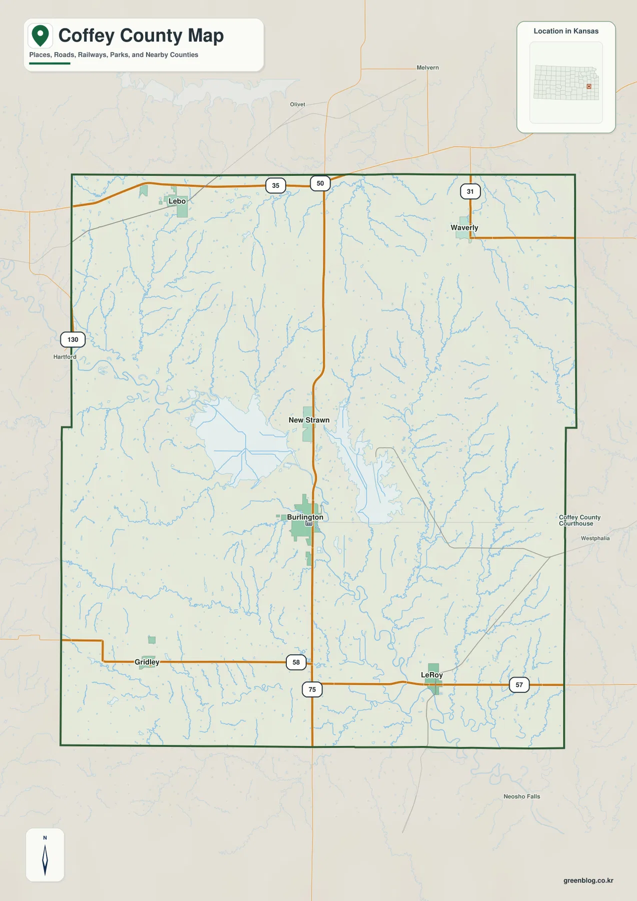
The pale blue stream network visible beneath the road information hints at the terrain that becomes more obvious on the later maps. Roads cross a county cut by many short tributaries and by the broad central reservoir and river lowlands. This general map is therefore useful for orientation, but it should not be treated as a live navigation service or a legal boundary survey. Current closures, construction, or property-boundary questions require up-to-date official sources designed for those purposes.
Six principal communities spread from Lebo to LeRoy
The city map ranks six principal communities and reduces much of the background detail so their spacing is easier to compare. The production-period city index printed on the map lists Burlington at 2,605, Lebo at 760, Waverly at 625, LeRoy at 510, New Strawn at 396, and Gridley at 393. Those figures should be treated as reference values associated with the map rather than a replacement for the latest Census estimates. For current population statistics, consult a recent official data release.
What remains especially useful is the geographic arrangement. Burlington is centrally placed in the lower half of the county, with New Strawn directly to its north. Lebo and Waverly occupy widely separated positions along the northern part of the county, while Gridley and LeRoy are similarly separated across the south. That arrangement shows why no single east-west or north-south line captures the whole settlement pattern. Roads, reservoirs, and stream valleys all influence how the communities relate to one another on the ground.
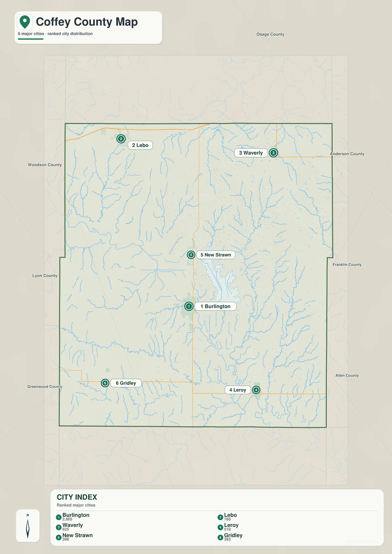
If straight connector lines appear on the city map, they are visual distance comparisons rather than driving routes. That distinction matters here because major water bodies and stream valleys occupy a large part of the central county. A road trip between two towns may follow highways around a reservoir or across specific bridge crossings, so actual travel distance can differ substantially from a straight line. The city map is best for learning relative position; current route planning belongs in an up-to-date navigation source.
John Redmond Reservoir, Coffey County Lake, and the Neosho River
The terrain and water map gives the central part of Coffey County a very different visual emphasis. John Redmond Reservoir is the broad water body west of the center, while Coffey County Lake occupies another large area to the east. The Neosho River bends through the lower central section and continues southward. The U.S. Army Corps of Engineers describes John Redmond Reservoir as a project on the Neosho River about three miles northwest of Burlington, which matches the relationship visible on the supplied map.
Several named tributaries help explain the rest of the drainage network. Lebo Creek appears in the northwest, Rock Creek descends through the northeastern part, and Wolf Creek, Long Creek, and Crooked Creek are prominent on the eastern side. North Big Creek and South Big Creek cross the southwestern area. These named streams are only part of a much denser web of smaller channels, but together they show how water from the higher surrounding ground is directed toward the major reservoir and river lowlands.
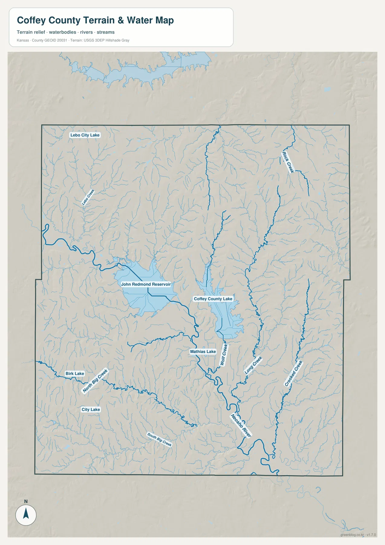
Smaller water bodies such as Lebo City Lake, Mathias Lake, Birk Lake, and City Lake are also labeled. Their presence helps distinguish local lakes from the much larger reservoir system. This map is a geographic reference, not a flood forecast, boating chart, or real-time lake-level display. Anyone who needs current releases, water levels, closures, or safety information should consult the agency that operates or monitors the relevant water body.
A 292–382 meter landscape shaped by broad lowlands and rolling hills
The elevation map shows an actual county range of roughly 292 to 382 meters, with a mean elevation of about 336 meters. The broad green lowland through John Redmond Reservoir, Coffey County Lake, and the Neosho River stands out immediately. This lower terrain forms a wide central belt rather than a narrow canyon, especially around the reservoirs. Tributary valleys branch outward from that belt, creating green fingers that extend into the surrounding uplands.
Higher ground appears in yellow, orange, and brown across much of the north and along several outer parts of the county. The relief is not mountainous; instead, repeated ridges and short valleys create rolling terrain. Numerous small streams have cut into those uplands, so the shaded surface looks finely dissected even where the overall elevation difference is moderate. The roughly 90-meter county range is enough to make the water corridor visibly lower than the surrounding country.
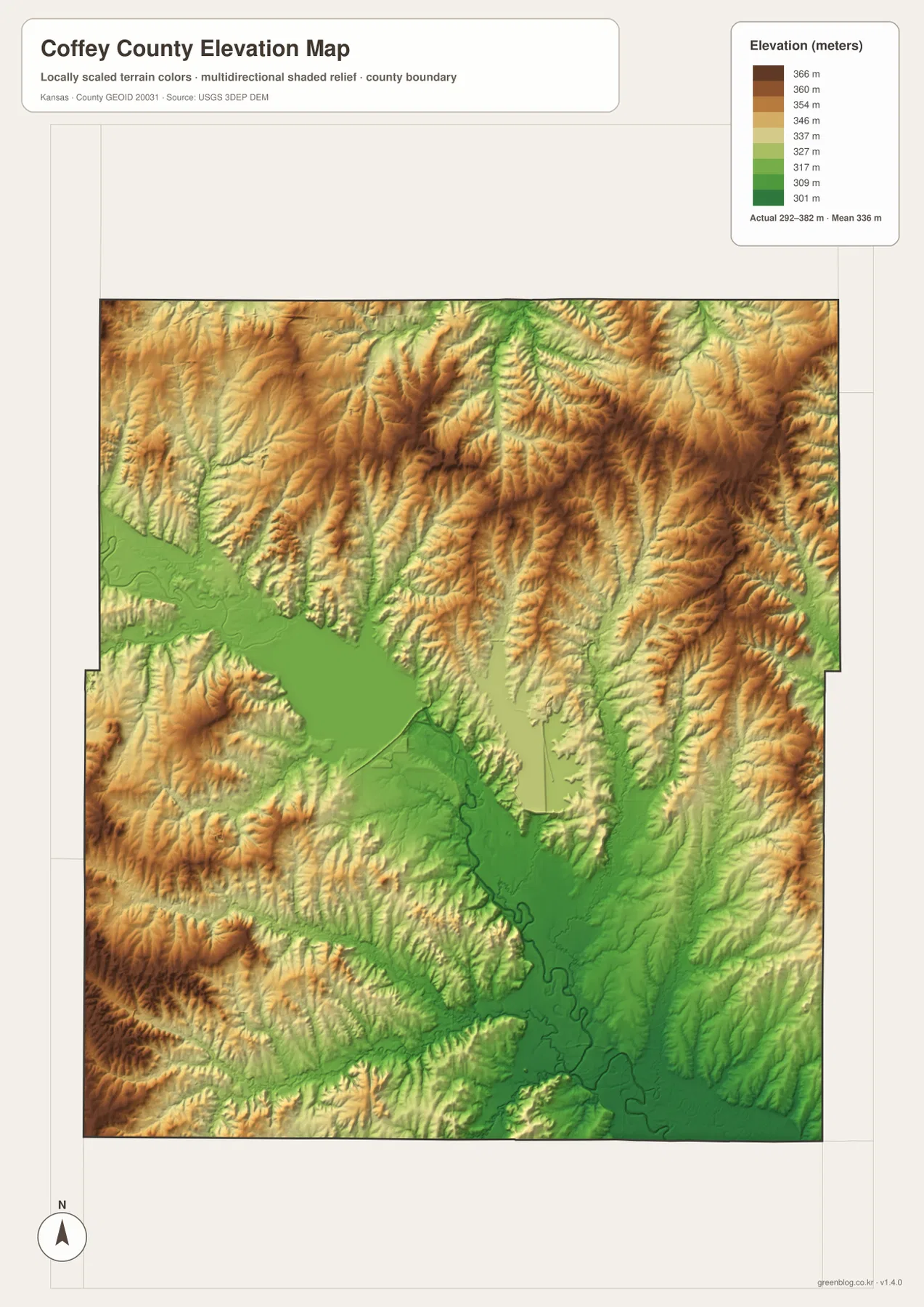
This elevation surface is intended for visual comparison across the county. It is not survey-grade data for establishing an exact property elevation, designing drainage, or making engineering decisions. Its value is broader: the map makes it easy to see that Burlington and the central water system occupy a relatively low part of the county, while higher ridges rise around many tributary valleys. That context also explains why the water map contains such a dense branching stream network.
Choosing the right map for a practical task
For a quick county overview, begin with Burlington on the general map and use U.S. 75 to establish north and south. From there, Lebo and Waverly can be located across the north and Gridley and LeRoy across the south. Once those settlements are familiar, the two large central water bodies provide an easy second set of landmarks. This sequence works well for classroom handouts, regional orientation, trip preparation, and any project that needs a clear county-wide reference without excessive detail.
If the question is about natural geography, start with the Neosho River instead. Follow it toward John Redmond Reservoir, compare the separate Coffey County Lake basin to the east, and then use the elevation view to identify the low corridor surrounding those waters. Named creeks such as Wolf Creek, Long Creek, Rock Creek, and Big Creek provide smaller reference points for the outer parts of the county. Linking towns to these features makes the physical setting much easier to remember than studying place names in isolation.
For printing or use in a document, the high-resolution JPG files in the ZIP are more suitable than relying on the reduced web previews. They preserve the original map dimensions and make labels easier to read at larger sizes. Before republishing or modifying a map, check the relevant source and attribution requirements. Projects that depend on current roads, live water conditions, or exact elevations should pair these reference maps with the latest data from the responsible public agency.
Frequently Asked Questions
Where is Burlington on the Coffey County map?
Burlington is in the central-southern part of the county near U.S. 75 and is the most prominent built-up area on the general map. New Strawn lies directly to the north, and John Redmond Reservoir is northwest of Burlington. Using Burlington as the first anchor makes the other towns, lakes, and highways much easier to place.
How are John Redmond Reservoir and the Neosho River related?
John Redmond Reservoir is located on the Neosho River northwest of Burlington. On the water map, the reservoir occupies a broad central lowland and the Neosho River continues through the lower central part of the county. Current lake level or release information can change, so those details should be checked with the U.S. Army Corps of Engineers or another current monitoring source.
Can the elevation map be used for engineering or property surveys?
No. The elevation map is designed to compare county-wide relief and show the relationship between low valleys, reservoirs, and higher rolling ground. Exact site elevations, drainage design, construction, or legal survey work requires purpose-built data and professional methods appropriate to the task.
Map File Information
Download the high-resolution JPG files corresponding to the Coffey County general, city, terrain-and-water, and elevation maps in one ZIP archive.
- Included Files: Use only the versions confirmed in the article and supplied images
- File Type: Use the confirmed download contents
- Intended Use: Printing, education, presentations, and map-based projects
Related Maps
Sources and references
- Coffey County, Kansas official website — county services and local information
- U.S. Army Corps of Engineers — John Redmond Reservoir — official reservoir location and project information
- U.S. Census Bureau TIGER/Line — county boundary and geographic data resources
- USGS 3D Elevation Program — elevation data information
Green Map creates custom-edited map images using open geographic data sources such as geoBoundaries, Natural Earth, OpenStreetMap, and government open data.
These maps are edited visual materials, not raw data files, and are provided for education, documents, presentations, and graphic reference.