Cherokee County occupies the far southeastern corner of Kansas, close to both Missouri and Oklahoma. Columbus sits near the middle of the county, while Baxter Springs and Galena form a more concentrated group of towns in the southeast. Weir, Scammon, and West Mineral are spaced across the northern half, so the settlement pattern is not organized around a single continuous urban strip. This page uses the supplied maps to explain roads, towns, streams, lakes, and elevation, and the matching high-resolution JPG files can be downloaded together as a ZIP. High-resolution map files are available for download in the section below.
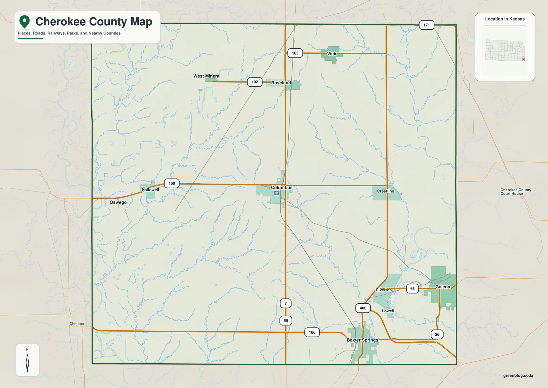
The general county map gives the quickest orientation. U.S. 160 crosses the county through Columbus, while U.S. 69 and U.S. 400 become especially important around Baxter Springs. K-66 and K-26 help locate Galena and the eastern edge, and smaller state routes such as K-102, K-103, and K-171 appear farther north. Rather than radiating from one dominant center, the road network links several separate town clusters that sit at different distances from Columbus.
The natural landscape adds another layer to that pattern. The Neosho River lies along the western side, while the Spring River runs through the east and southeast. Brush Creek, Cherry Creek, Shawnee Creek, Little Shawnee Creek, and other smaller channels divide the interior into a series of valleys. The elevation map gives an actual range of about 231 to 319 meters, with a mean near 265 meters, making the contrast between river lowlands and the central uplands easy to see.
Table of Contents
Using Columbus to orient the county before moving north or southeast
Columbus is the most useful starting point because it lies close to the center of Cherokee County. The official county website identifies Columbus as the county seat, and the map shows U.S. 160 running directly through the city. Once Columbus is located, Baxter Springs can be found well to the south, Galena to the east, and the smaller northern towns by moving toward the upper half of the map. This central position makes Columbus a practical reference even when the destination is in a different part of the county.
The southeastern corner has the densest concentration of named places and major roads. Baxter Springs is close to the southern county line where U.S. 69 and U.S. 400 come together, while Galena lies farther east near K-66 and K-26. Riverton and Lowell appear between and around those larger towns. On the general map, this creates a compact network of roads and settlements that looks quite different from the more widely spaced northern half.
North of Columbus, the spacing changes. Weir occupies the northeastern part of the county, Scammon lies to its west, and West Mineral is farther northwest. Roseland also appears between the northern towns and Columbus. Because these communities are separated by more open ground, it is helpful to locate them on the city-distribution map first and then return to the general map to follow the smaller state highways and local connections.
The surrounding counties and state-edge context also matter. Labette County is to the west and Crawford County is to the north, while Cherokee County lies close to the Kansas borders with Missouri and Oklahoma. That position explains why the eastern and southern parts of the map contain several routes leading toward neighboring states. The map is useful for geographic orientation, but it should not be used as a legal parcel or boundary survey; official records are needed for those purposes.
Why Baxter Springs, Columbus, and Galena dominate the city-distribution map
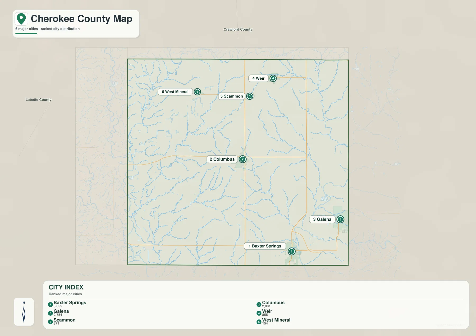
The city-distribution map highlights six places and gives a value beside each one. The displayed values are Baxter Springs 3,855, Columbus 2,881, Galena 2,754, Weir 557, Scammon 371, and West Mineral 154. Those figures are best treated as the values printed on this map for relative comparison rather than as a substitute for a current population table. For the latest demographic counts, Census or local-government sources should be checked separately.
The strongest visual pattern is the large gap between the first three places and the three smaller northern towns. Baxter Springs, Columbus, and Galena are all prominent, but they are not clustered at one point. Columbus is central, Baxter Springs is southern, and Galena is eastern. Their triangular arrangement makes the road network important: U.S. 160 connects the central part of the county, while U.S. 69 and U.S. 400 organize much of the southeastern travel pattern.
Weir, Scammon, and West Mineral tell a different story. They are spaced across the north and do not form a single dense band. Weir and Scammon are relatively close to one another, but West Mineral sits farther west. When a small northern town is the destination, the city map is useful for the first visual check, while the general map supplies the road numbers and nearby settlements that make the route easier to understand.
This split between the central-southeastern centers and the northern small towns is one of the clearest county-specific patterns in the set. Administrative orientation may begin with Columbus, but many trips in the southeast are just as likely to be organized around Baxter Springs or Galena. A visitor preparing a route should therefore decide which part of the county is relevant before zooming into local roads, streams, or relief.
Between the Neosho River and Spring River: streams, lakes, and interior valleys
On the terrain-and-water map, the western side is anchored by the Neosho River and by tributaries that approach it from the interior. Lightning Creek and Cherry Creek are among the clearly labeled streams, and several small lakes appear in the southwestern quarter, including Hubbell Lake and Hines Lake. This side of the county shows a broad lowland character compared with the higher colors that dominate parts of the central interior.
The eastern and southeastern side is organized around the Spring River. The river follows the eastern side and continues southward near the cluster of Galena and Baxter Springs. Spring River Lake is shown in the southeastern part of the water map. When this layer is compared with the road and city maps, the southeastern settlement cluster can be seen as a place where roads, towns, and a major river corridor occupy the same relatively compact area.
Across the middle of the county, Brush Creek runs through a long interior valley, while Shawnee Creek and Little Shawnee Creek appear farther east. These streams are less prominent than the two major rivers, but they are important for understanding why the interior relief is broken into many ridges and shallow valleys rather than forming one smooth plateau. Small tributaries repeatedly cut across the higher ground visible on the elevation map.
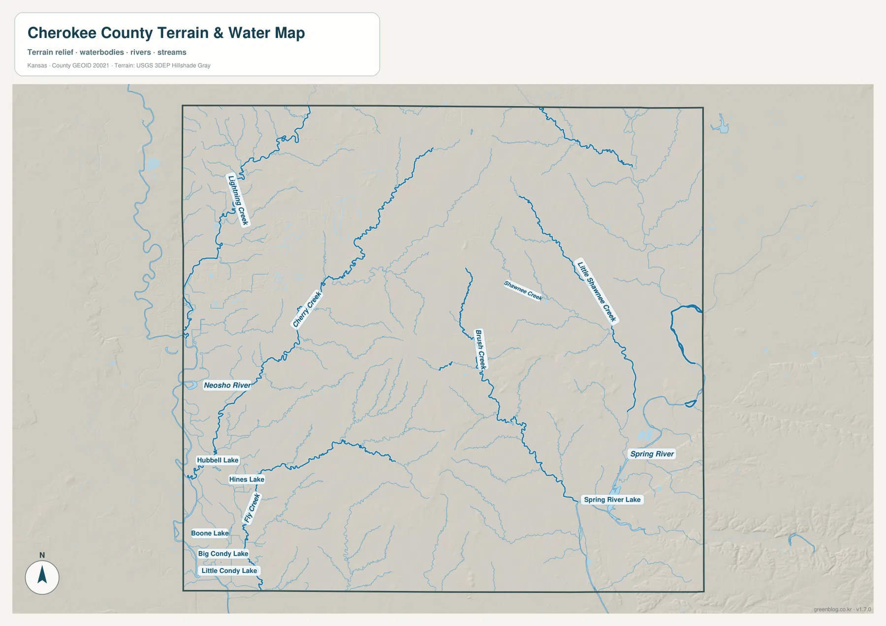
The water layer is designed for geographic comparison, not for real-time conditions. It does not provide current river stage, flood warnings, water depth, fishing regulations, or public-access status. Those details can change and should be checked with the appropriate agencies before a field visit. Here, the value of the map is in showing how named towns and road corridors sit in relation to the major rivers, tributaries, and low valleys.
A 231–319 meter landscape of low river margins and central ridges
The elevation map reports an actual range from about 231 to 319 meters and an average near 265 meters. The western side contains broad green areas that represent lower ground, while brown and orange areas mark higher ridges across the north-central and central-eastern parts of the county. The total difference is roughly 88 meters, so Cherokee County is not mountainous, yet the river lowlands and rolling uplands are visually distinct.
Around Weir, Scammon, and the country north of Columbus, the higher ground appears in several connected blocks separated by narrow drainage valleys. Westward toward the Neosho River, the colors become lower and more continuous. This change helps explain why the water map shows so many tributaries leaving the central area and moving toward the larger river valleys.
The southeast has another clear contrast. The Spring River corridor is lower, while ridges rise to the west and east of portions of the river. Baxter Springs and Galena sit close to this combination of urban roads, river lowlands, and surrounding higher ground. Looking at the elevation map after locating the two towns on the general map gives a more complete sense of the local setting than either layer provides on its own.
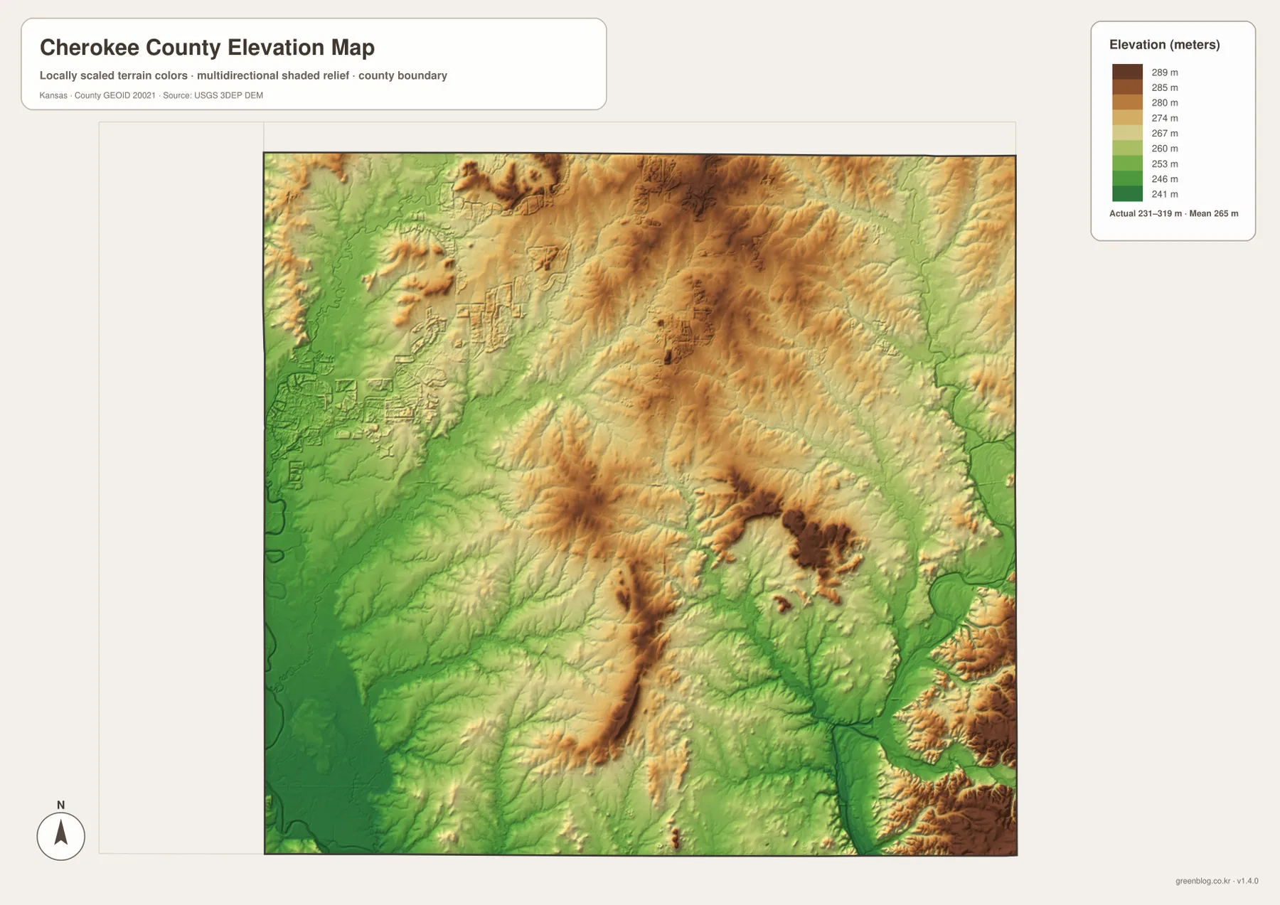
The shaded relief is meant to make broad landform differences easier to see; it is not a survey-grade source for the exact elevation of a property, road, or building site. Engineering, drainage design, or detailed site work requires original elevation data or professional measurements. For general map reading, however, this layer clearly shows why the county contains alternating ridges and stream-cut lowlands rather than one uniformly flat surface.
Following U.S. 160, U.S. 69, and U.S. 400 through the county
Three highways provide an easy framework for reading the road map. U.S. 160 crosses the middle of Cherokee County through Columbus and gives the clearest east-west reference. U.S. 69 runs south from the Columbus area toward Baxter Springs, while U.S. 400 becomes important in the southeast near Baxter Springs and Galena. With these routes fixed in mind, smaller towns and state highways become much easier to place.
The northern half uses a different set of route references. K-102 appears near West Mineral and Roseland, K-103 serves the area around Weir, and K-171 reaches the northeastern edge. These smaller highways are especially useful when the destination is Scammon, Weir, or West Mineral because the major U.S. routes are farther south. Switching between the city-distribution map and the general map makes those northern relationships much clearer.
In the southeast, K-66 is a strong visual marker through Galena, while K-26 appears south and east of the same cluster. Riverton and Lowell are smaller labels that can be easy to miss at first glance, but they help explain the local road geometry between Galena and Baxter Springs. The combination of several numbered routes, a major river, and closely spaced towns makes this the most detailed part of the county map.
Choosing the most useful downloadable map for the task
For a quick overview of towns and highways, the general county map is the best starting point. It shows Columbus, Baxter Springs, Galena, northern communities, and the main numbered routes in one view. The city-distribution map is better when the goal is to compare the six highlighted places and see how the larger southeastern and central centers differ from the smaller northern towns.
The terrain-and-water map is the better choice for rivers, tributaries, and lakes. It makes the Neosho River and Spring River easy to compare and also labels Brush Creek, Cherry Creek, Little Shawnee Creek, Hubbell Lake, Spring River Lake, and other water features. When relief is the main interest, the elevation map provides the clearest view of the 231–319 meter range and the higher ridges between river corridors.
The web images are sized for convenient on-page viewing, while each source JPG is 3638 by 2572 pixels. The full-resolution files are more useful when small road numbers, stream names, city labels, or shaded-relief details need to be enlarged for a presentation, classroom handout, personal reference, or general printing. The ZIP below contains the four JPGs corresponding to the general, city-distribution, terrain-and-water, and elevation maps shown on this page.
These maps are general geographic references rather than live navigation, flood-control, property-boundary, or engineering products. Current road conditions, flood information, parcel boundaries, and precise site elevations require up-to-date authoritative sources. A practical workflow is to locate Columbus or the southeastern towns on the general map, compare the nearby river corridor on the water map, and then use the elevation layer to understand the surrounding ridges and lowlands.
Frequently Asked Questions
Which map is best for comparing Columbus with Baxter Springs and Galena?
Start with the general county map. Columbus is near the center on U.S. 160, Baxter Springs is in the south around U.S. 69 and U.S. 400, and Galena is farther east near K-66 and K-26. If you also want to compare the relative size of the six highlighted places, use the city-distribution map next.
Where are the Neosho River and Spring River within Cherokee County?
On the supplied terrain-and-water map, the Neosho River is on the western side of the county, while the Spring River runs along the east and southeast. Interior streams such as Brush Creek, Cherry Creek, and Little Shawnee Creek divide the higher ground between them. Comparing the water and elevation maps makes the associated low valleys easier to see.
What is included in the downloadable ZIP?
The ZIP contains four high-resolution JPGs corresponding to the general county map, city-distribution map, terrain-and-water map, and elevation map. Each source image is 3638 by 2572 pixels, which makes small road numbers, place labels, water names, and relief details easier to inspect than in the web previews.
Map File Information
Download the high-resolution JPG originals corresponding to the Cherokee County general map, city-distribution map, terrain-and-water map, and elevation map shown on this page.
- File Type: ZIP containing 4 JPG files
Related Maps
Sources and reference links
For county background and the designation of Columbus as the county seat, see the official Cherokee County, Kansas website. Boundary and base geography can be cross-checked with U.S. Census Bureau TIGER/Line Shapefiles; hydrography is available through USGS National Hydrography; and elevation data are available through the USGS 3D Elevation Program. The local descriptions on this page are based on the towns, roads, rivers, lakes, and elevation range visible in the supplied Cherokee County maps.
Green Map creates custom-edited map images using open geographic data sources such as geoBoundaries, Natural Earth, OpenStreetMap, and government open data.
These maps are edited visual materials, not raw data files, and are provided for education, documents, presentations, and graphic reference.