Winneshiek County in northeastern Iowa is centered on Decorah, but the county is shaped just as much by winding rivers, deeply cut valleys, and a scattered network of smaller towns. Decorah sits a little east of the county’s center, where Iowa 9 and U.S. 52 provide useful reference lines. Calmar, Ossian, Spillville, Fort Atkinson, and Ridgeway are spread across the southern and western parts of the county rather than forming one continuous urban area. The map files shown on this page are also available as high-resolution JPG images in a ZIP download for printing, close-up viewing, or personal reference.
The road map gives a quick sense of where the towns are, but the water and elevation maps explain why Winneshiek County looks so different from a simple grid of roads. The Upper Iowa River enters from the northwest, swings across the northern half of the county, and passes near Decorah before continuing east. Canoe Creek, the Trout River, the Turkey River, and the North Fork Yellow River occupy other valleys across the county. On the elevation map, these waterways correspond to green lowlands surrounded by tan and brown uplands, making the relief especially easy to see.
The supplied set includes a county orientation map, a ranked city-distribution map, a terrain-and-water map, and an elevation map. Rather than treating them as four unrelated pictures, it is more useful to follow the same places from one map to another. Decorah provides the clearest starting point, followed by the southern group around Calmar and Ossian, then the Upper Iowa River valley and the smaller river systems that cut through the rest of the county.
Table of Contents
Decorah at the Meeting Point of Iowa 9, U.S. 52, and the River Valley
Decorah is the easiest landmark to use when orienting yourself on the county map. The built-up area appears near the Upper Iowa River, while Iowa 9 approaches from the west through the Ridgeway area and continues east beyond Decorah. U.S. 52 comes up from the southeast and passes through the Decorah area before continuing north. Route 150 runs south toward Calmar, giving the central part of the county a clear north-south reference. Once those roads are located, the positions of the smaller communities become much easier to understand.
Ridgeway lies west of Decorah near Iowa 9, with broad rural areas extending toward the county’s western side. Farther south, Calmar occupies a useful central position among several smaller communities. Spillville and Fort Atkinson are to the west and southwest of Calmar, while Ossian is to the southeast. Castalia appears farther east beyond Ossian. The towns do not line up along one corridor, so a county-wide map is more useful than a narrow road strip when the goal is to understand how the communities are distributed.
Other numbered roads help define the edges of this pattern. Route 139 appears near the northwestern side of the county, while Route 24 is marked near Fort Atkinson in the southwest. Route 150 continues south from Calmar, and U.S. 52 provides the principal reference through the southeastern side. These roads are useful for regional orientation, but the map is not a live navigation product. Construction, local road conditions, seasonal closures, and exact travel times should be checked with current navigation services and Iowa transportation information.
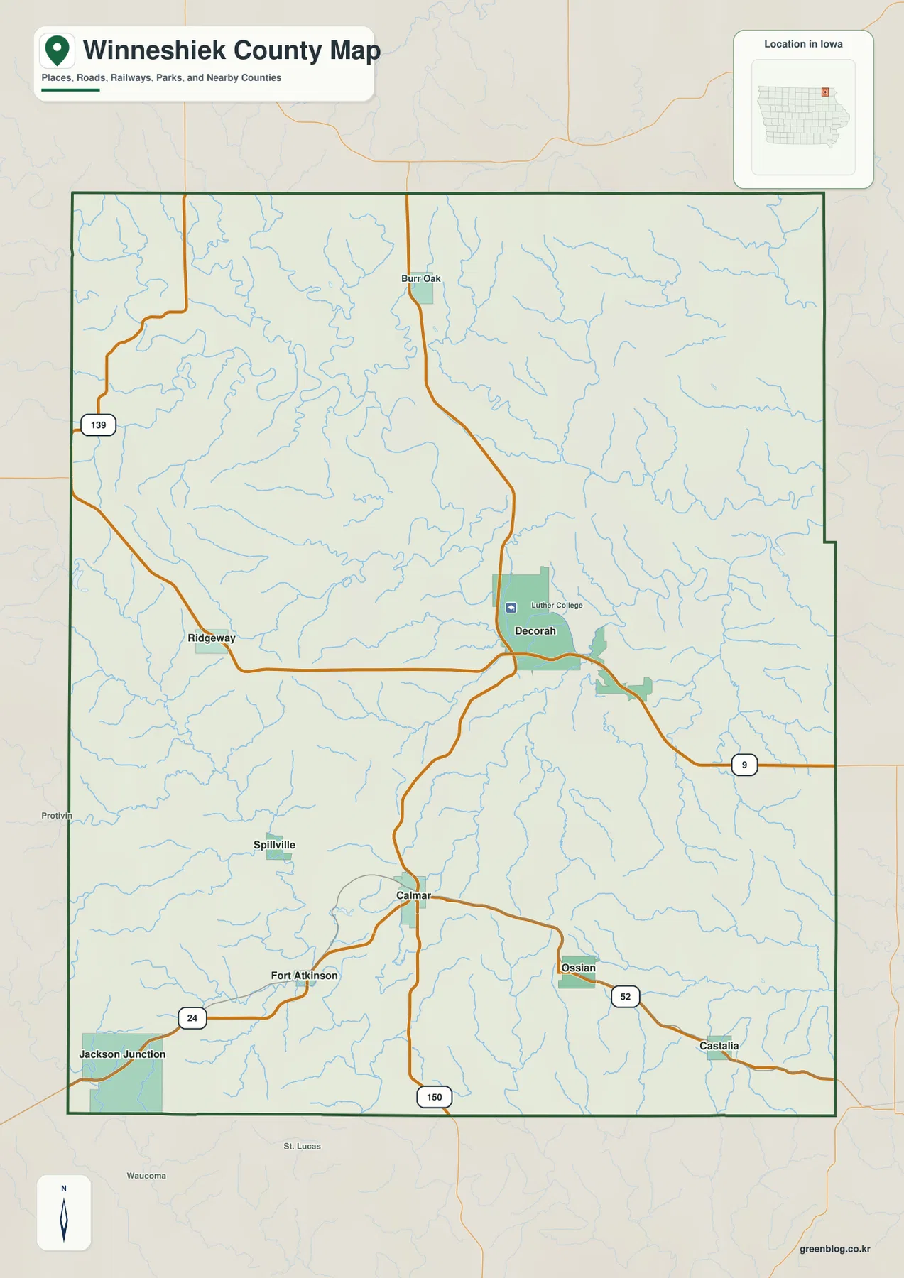
Luther College is also labeled close to Decorah, providing another recognizable point near the city and river. The map is designed for county orientation, however, not for campus boundaries, property lines, or engineering measurements. Parcel ownership, legal boundaries, road rights-of-way, and site-specific planning require official county records or surveyed information. For general map reading, the strength of this view is its combination of towns, roads, waterways, and the county outline without requiring the reader to switch between several separate reference maps.
Six Major Towns Show a Strong Decorah Center and a Dispersed South
The city map simplifies the background and ranks six communities, making the difference between Decorah and the smaller towns immediately visible. The index printed on the supplied map lists Decorah at 7,553, Calmar at 974, Ossian at 806, Spillville at 356, Fort Atkinson at 346, and Ridgeway at 315. These figures should be treated as the values used to build the map rather than as a promise that they match the latest official estimate. Their main purpose here is to show the large size gap between Decorah and the other mapped communities.
The spatial pattern is just as useful as the ranking. Decorah is east of center, Ridgeway is to the west, and Calmar lies well to the south. Spillville and Fort Atkinson occupy the southwestern side, while Ossian is southeast of Calmar. The map also labels neighboring counties around the edge, including Allamakee and Clayton to the east and Howard and Chickasaw to the west. That surrounding context helps explain which communities are closer to another county boundary and which sit farther inside Winneshiek County.
Decorah’s importance is not only a matter of population. It is close to the Upper Iowa River and sits where several major road references meet, so it works as a geographic anchor for the northern half of the county. Calmar plays a different role on the map: its southern location makes it a convenient point for relating Fort Atkinson, Spillville, and Ossian to one another. Ridgeway provides the western comparison point. Returning from the city map to the road map makes it easier to connect these town names with the routes that pass nearby.
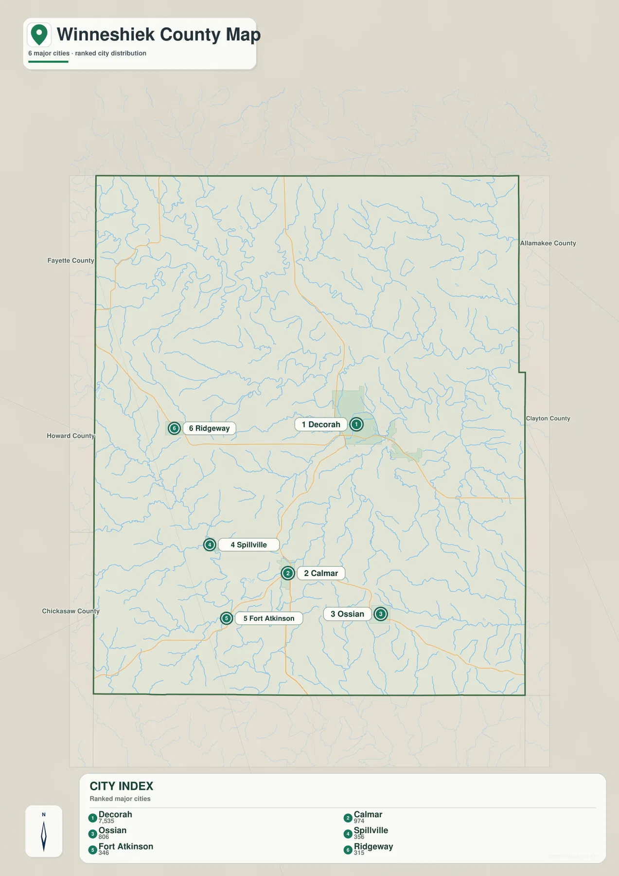
The ranking should not be read as a complete measure of civic importance, services, or employment. A smaller community may still be important for nearby rural areas, schools, parks, local businesses, or cultural sites. For map use, the most reliable takeaway is the spacing: the six towns are separated by substantial rural areas rather than forming a continuous chain. That becomes especially meaningful when the water and elevation maps are added, because the land between the towns is divided by river valleys, smaller creeks, and higher ridges.
The Upper Iowa River Bends Across the North while Turkey and Yellow River Valleys Shape the South
The Upper Iowa River dominates the terrain-and-water map. It enters from the northwest and follows a broad, winding course across the northern and central part of the county before leaving to the east. Its valley is visible not only as a blue waterway but also through the shaded relief around it. Near Decorah, the river sits inside a pronounced low corridor, so the city’s relationship to the valley is much clearer here than on a road-only map. Large bends repeatedly push the channel toward different sides of the valley.
Several smaller waterways join or approach the Upper Iowa system. Pine Creek and Silver Creek are labeled on the northwestern side, while Canoe Creek occupies a long valley east of the river. Hawks Ponds appears toward the north. The number of branching blue lines is important because it shows that the northern half of Winneshiek County is not one broad flat surface. Narrow valleys extend into the surrounding uplands, dividing the higher ground into ridges and slopes that are easy to miss on a standard road map.
The southern half has its own set of waterways. The Turkey River winds through the southwest, with Lake Meyer labeled nearby. Dry Run and Ten Mile Creek appear across the central-southern area. Farther east, the Trout River and Trout Creek occupy neighboring valleys, while the North Fork Yellow River and Yellow River run across the southeast near Walden Pond. These southern streams are smaller than the Upper Iowa River on the map, but together they explain much of the fine-grained relief visible across the lower half of the county.
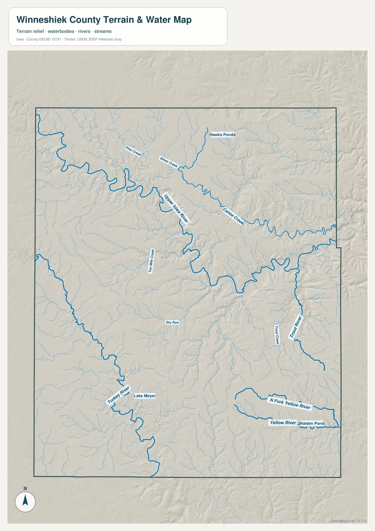
County and local recreation sources emphasize waterways, parks, trails, and trout fishing as important parts of the Winneshiek County landscape, which fits the dense network visible on the map. That does not make this image a flood map, a legal stream-boundary map, or a guide to current fishing access. Water level, public access, regulations, and seasonal conditions can change. For those questions, current information from the USGS, Iowa DNR, Winneshiek County Conservation Board, and local agencies should be used alongside this general reference map.
A 226–417 Meter Elevation Range Reveals Deep Valleys between High Ridges
The elevation map gives an actual mapped range of about 226 to 417 meters, with a mean of about 348 meters. That roughly 190-meter difference is large enough to produce a strong visual contrast. The Upper Iowa River and major tributary valleys appear in dark and medium greens, while the surrounding uplands shift through lighter tones into tan and brown. The most useful feature is not any single elevation number but the way the low river corridors form long, branching shapes between the higher ridges.
Across the northern half of the county, the Upper Iowa River cuts a sinuous low corridor through substantially higher ground. The low zone becomes broader around some river bends, while tributaries such as Canoe Creek extend narrow green valleys into the uplands. Decorah lies close to this system, so the elevation view makes it clear that the city is associated with a major valley rather than an uninterrupted plain. Comparing the water and elevation maps side by side is especially effective because the blue river lines and green lowlands correspond closely.
The south is also broken by valleys even though it lacks one dominant river as large as the Upper Iowa. The Turkey River creates a low corridor in the southwest, while the Trout and Yellow River systems form additional low areas toward the southeast. Between them, the Calmar and Ossian area contains broader higher ground, but smaller drainage lines still cut into it. A straight line between two towns therefore does not describe the terrain a traveler may encounter. Roads may follow valleys, cross streams, or climb between lower and higher ground.
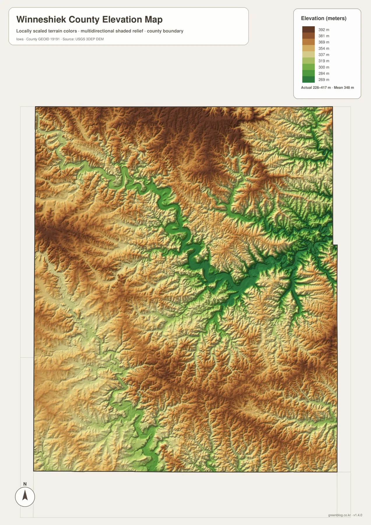
This map is intended for county-scale comparison, not survey-grade measurement. It should not be used to determine a parcel’s exact elevation, a building foundation height, a road grade, or an engineered drainage design. Those tasks require official datasets, field measurements, and professional survey or engineering information. For ordinary geographic reading, however, the map is very effective at showing why the Upper Iowa River valley stands out so strongly and why the southern streams create a similarly dissected landscape on a smaller scale.
Using the Same Town as a Reference Makes the Four Views Easier to Compare
For Decorah, begin with the county map and locate Iowa 9, U.S. 52, the built-up area, and the nearby river. Then move to the water map and find the large Upper Iowa River bends and Canoe Creek. On the elevation map, the same area becomes a green valley bordered by higher brown and tan ridges. Following one place through several maps is more informative than reading each map in isolation, because it connects the town, roads, river, and relief into one geographic picture.
Calmar works well as a southern reference point. The city map places Spillville and Fort Atkinson to its west and Ossian to its east. The water map then shows that this area lies between several separate river systems rather than directly on the Upper Iowa main stem. The elevation view adds another layer: broad uplands remain around Calmar and Ossian, but many small valleys cut into them. This explains why the southern part of the county can look open on a road map while still having complicated local relief.
Ridgeway provides a useful western comparison. It sits along the Iowa 9 corridor, but the western side of the county also contains tributary valleys connected to the Upper Iowa system. On the eastern side, waterways continue toward the Allamakee and Clayton County boundaries. For trip planning or local study, the map set works best when general orientation comes first and terrain detail comes second. Current road conditions, park access, fishing rules, and water levels should always be checked through the appropriate official source because those details can change.
The original JPG files in the download archive are helpful when labels need to be enlarged or printed. The county map is the best general overview of towns, roads, boundary, and water. The city map simplifies the distribution of the six ranked communities. The terrain-and-water map focuses attention on the Upper Iowa River and the southern river systems, while the elevation map makes the contrast between valleys and ridges easiest to see. When several maps are used together for a class project or personal research, choosing one town as a common reference point reduces confusion between the different views.
Frequently Asked Questions
Which map is best for comparing Decorah and Calmar?
Start with the county map because it shows both towns together with the principal roads. Decorah is the larger center near Iowa 9, U.S. 52, and the Upper Iowa River, while Calmar is farther south near Route 150 and the cluster of southern communities. The city map makes their relative size and spacing easier to compare. If terrain matters, the elevation map adds an important difference: Decorah is close to the deep Upper Iowa River valley, while Calmar sits amid broader southern uplands cut by smaller streams.
Where does the Upper Iowa River run through Winneshiek County?
On the supplied terrain-and-water map, the Upper Iowa River enters from the northwest and follows a winding course across the northern and central part of the county. It passes through the Decorah area and continues toward the eastern county line. Pine Creek, Silver Creek, and Canoe Creek are among the smaller waterways shown near the system. The elevation map marks the same route as a long green lowland. For current river level or flood information, use live USGS and local-agency sources rather than this general reference image.
Can the 226–417 meter elevation map be used for surveying or building design?
No. The map is useful for comparing the county’s major low valleys and high ridges, but it is not a parcel survey or an engineering-grade elevation model. It can show that the Upper Iowa River occupies a pronounced low corridor and that other valleys cut through the southern uplands, but it does not provide the precise site measurements needed for construction, drainage design, property transactions, or road engineering. Those uses require official data and site-specific professional measurements.
Map File Information
The ZIP contains high-resolution JPG files corresponding to the Winneshiek County county, city, terrain-and-water, and elevation maps shown on this page.
- File Type: ZIP containing 4 JPG files
Related Maps
Sources and References
These official and local resources provide additional information about Winneshiek County, its outdoor areas, and the boundary, water, and elevation datasets used for geographic reference.
- Winneshiek County official website – county government and local information
- Winneshiek County Conservation Board – county parks and outdoor recreation information
- Decorah Parks & Recreation Trail Maps – trail maps for Decorah and the surrounding county
- U.S. Census Bureau TIGER/Line – boundary and transportation geography data
- USGS National Hydrography – river, stream, and water-feature data
- USGS 3D Elevation Program – elevation data
Green Map creates custom-edited map images using open geographic data sources such as geoBoundaries, Natural Earth, OpenStreetMap, and government open data.
These maps are edited visual materials, not raw data files, and are provided for education, documents, presentations, and graphic reference.