Wayne County sits on Iowa’s southern edge, directly north of Missouri, with Corydon near the middle of a landscape of small towns, farm roads, rolling uplands, and narrow creek valleys. Iowa 2 crosses the county from west to east through Corydon, while Iowa 14 provides an important north-south reference. The maps on this page show where Corydon, Seymour, Humeston, Allerton, Lineville, and other communities sit in relation to those roads, South Fork Chariton River, local lakes, and terrain ranging from about 275 to 341 meters. High-resolution JPG versions of the four supplied maps are also available in a downloadable ZIP.
Corydon is the easiest place to start because it lies near the center of the county. Humeston is northwest of it, Millerton is north, Promise City is east, and Seymour is southeast. Allerton lies farther south, while Clio and Lineville occupy the southwestern side; Lineville is especially useful as a reference because it sits close to the Missouri border. Wayne County is bordered by Decatur County on the west, Lucas County on the north, and Appanoose County on the east, so the general map also helps place the county within south-central Iowa.
The physical landscape is defined less by dramatic relief than by repeated low ridges and stream valleys. South Fork Chariton River forms the most prominent northern water corridor, while Corydon Lake and Corydon Lagoon provide smaller landmarks near the county seat. Jackson Creek, branches of Medicine Creek, Walnut Creek, Locust Creek, and other streams divide the central and southern uplands. When the water and elevation maps are compared, the relationship is easy to see: streams occupy the lower green valleys, and the higher rolling ground rises between them.
Table of Contents
Start with Corydon to understand the county road pattern
The general county map makes Corydon the natural orientation point. Iowa 2 enters from the west, passes through Corydon, and continues toward Promise City on the eastern side. Iowa 14 approaches from the north and meets the east-west route in the central part of town before continuing south. That crossing makes it much easier to judge where the smaller communities sit: Humeston and Millerton are on the northern side of the county, Seymour is southeast of Corydon, and Lineville is far to the southwest near the state line.
The settlement pattern is spread out rather than concentrated in a single continuous urban area. Humeston stands apart in the northwest, Clio lies in the southwest interior, and Lineville marks the southern edge. Allerton is south of Corydon, while Promise City and Seymour form two separate eastern references. Between these towns are large stretches of rural land crossed by county roads and small waterways. The map is useful because it shows those relationships on one page without the clutter of a turn-by-turn navigation display.
Promise City and Seymour illustrate why direction alone does not tell the whole story. Both are east of Corydon, but Promise City is closer to the Iowa 2 corridor while Seymour lies farther southeast. On the western side, Humeston and Lineville are also separated by a large north-south distance even though both are west of Corydon. Looking at the county in these pairs makes the road network easier to remember. For live closures, construction, travel times, or exact driving directions, however, current transportation and navigation services should be used instead of this reference map.
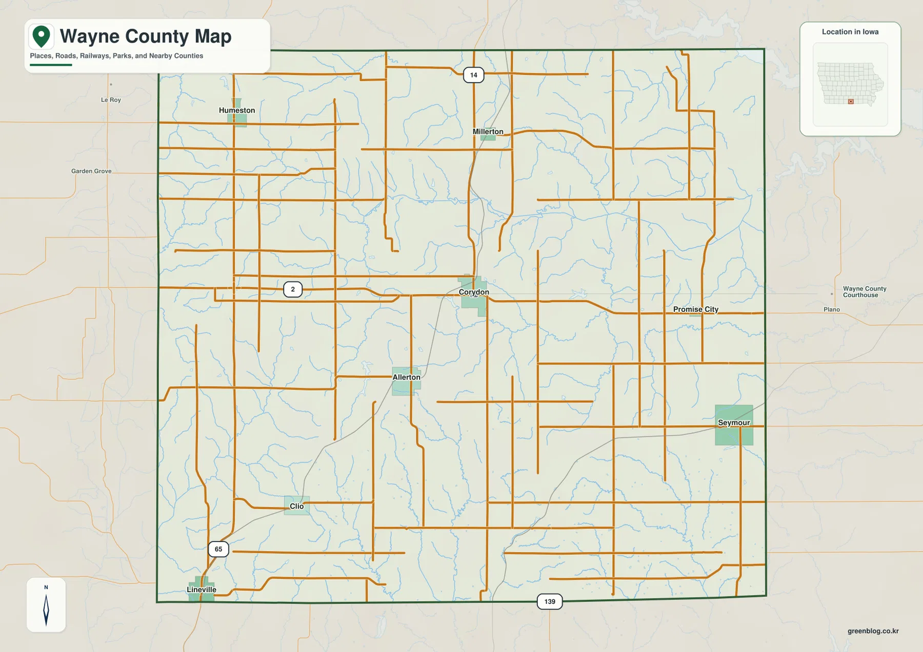
The county boundary adds another useful layer of context. Decatur County is immediately west, Lucas County is north, and Appanoose County is east. Lineville’s position near Missouri helps show how far south Wayne County extends, while Corydon gives a stable central reference. For regional study, trip preparation, or simply learning the geography of southern Iowa, the general map works best as the first layer before moving to the more specialized town, water, and elevation views.
Corydon, Seymour, and Humeston show how widely the towns are spaced
The city map ranks the larger communities included in the supplied data. It lists Corydon at 1,628, Seymour at 594, Humeston at 551, Allerton at 395, Lineville at 259, and Promise City at 105. These values are best treated as the population figures used to create the map rather than as a claim about the latest estimate. Their main purpose here is to make the relative size of the six communities easy to compare while also showing how far apart they are across the county.
Corydon is both the largest of the mapped towns and the county seat. Wayne County’s official history material notes that Corydon was chosen as the county seat in 1851, and its central location remains visually obvious on the map. From Corydon, Humeston lies northwest, Promise City east, Seymour southeast, Allerton south, and Lineville near the southwestern border. The arrangement makes it clear that Wayne County does not have one broad urban corridor; instead, its communities are separated by farmland, creeks, and rolling ground.
Those gaps matter when interpreting distance. Two towns may look fairly close on a county-scale map, yet the actual road route can bend around waterways or follow a different county road than a straight line would suggest. Humeston is associated with the heavily dissected northern side of the county near tributaries of South Fork Chariton River, while Allerton and Lineville sit among southern and southwestern uplands. Seymour and Promise City share the eastern side but occupy different local creek settings. The city layer becomes much more informative when those physical differences are kept in mind.
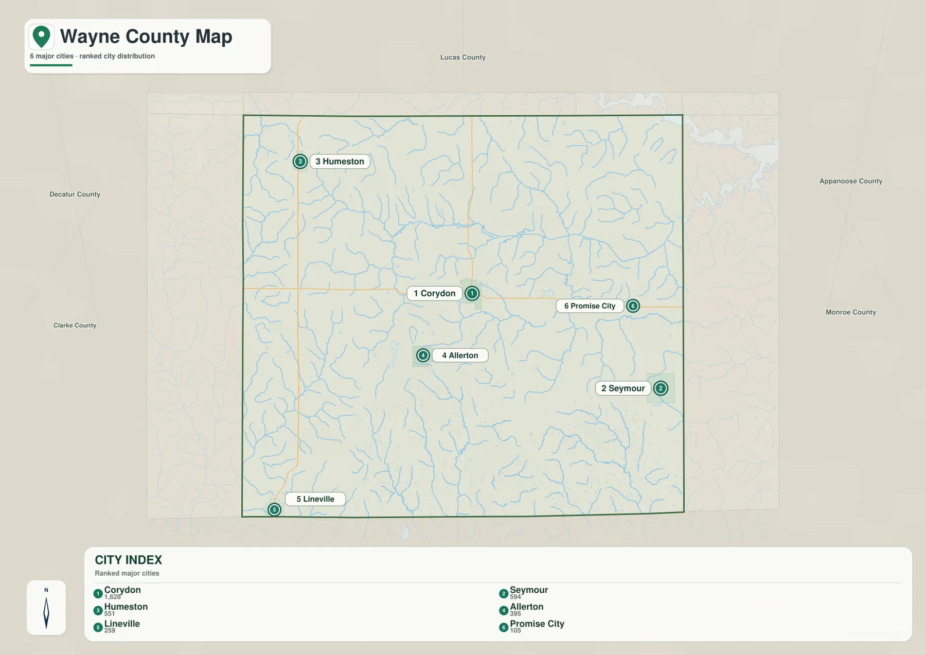
The map is especially useful for quickly distinguishing the central, eastern, northern, and border communities. Corydon provides the center, Seymour and Promise City separate the eastern side, Humeston anchors the northwest, and Lineville marks the southwest near Missouri. For current demographic totals, readers should consult the latest Census or local government data, but for spatial comparison the city index offers a concise view that is easy to combine with the road and terrain maps.
South Fork Chariton River dominates the north while smaller creeks divide the south
South Fork Chariton River is the most prominent named water feature on the supplied water map. It enters the northern portion of Wayne County from the west, bends across the north-central interior, and continues toward the eastern boundary. Numerous small tributaries join it, and Jordan Creek is visible on the northeastern side. The shaded terrain around the river shows a broad low corridor that is much easier to recognize here than on the road map.
Near Corydon, the two easiest water landmarks are Corydon Lake and Corydon Lagoon. They are much smaller than South Fork Chariton River, but their proximity to the county seat makes them excellent reference points when switching between maps. The City of Corydon identifies Corydon Lake Park as a local recreation area, connecting the mapped feature with a familiar place on the ground. Corydon itself lies south of the main South Fork Chariton valley, so the lake and lagoon help distinguish the town’s local drainage setting from the larger river corridor to the north.
Farther south and east, Wayne County is crossed by a collection of smaller named streams. W Jackson Creek and Jackson Creek lie southeast of Corydon, while E Fork Medicine Creek and Middle Fork Medicine Creek cross the south-central area. Caleb Creek appears in the southwest, and Walnut Creek and Locust Creek are mapped in the southeast. None forms a single dominant valley like South Fork Chariton River, but together they divide the rolling uplands into many narrow ridges and low creek bottoms.
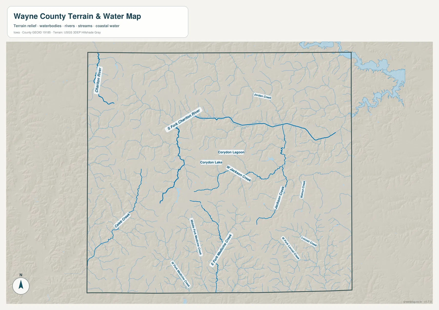
This is a geographic reference layer, not a flood-hazard or legal-water-boundary map. Stream levels, recreation conditions, and flood risk can change and require current official information. The most useful purpose of this layer is to connect names with landforms: South Fork Chariton River occupies a long northern lowland, while the smaller central and southern streams create shorter valleys among the uplands. That relationship becomes even clearer on the elevation map.
A 275–341 meter range reveals rolling western ground and low stream corridors
The elevation map gives Wayne County a reported range of about 275 to 341 meters, with an average near 319 meters. That is not mountain-scale relief, but the county is far from perfectly flat. Brown and tan areas mark relatively higher ground, while green follows lower valleys. The western and southwestern parts of the county contain broad areas of higher rolling land, and the South Fork Chariton River forms the clearest continuous low corridor across the north.
The western half is particularly textured. Around the Humeston-to-Lineville side of the county, narrow green drainage lines cut repeatedly through higher brown ground. Corydon also sits among low ridges and small valleys rather than on a completely level plain. This is a useful correction to the visual impression of the road map, where many rural roads appear straight. The road network may be regular, but the land underneath it rises and falls gently from one stream valley to the next.
In the north, South Fork Chariton River creates the most obvious low band. As tributaries join the river toward the east, the green valley widens in places. Jackson Creek and the Medicine Creek branches form lower corridors in the southeast and south-central parts of the county, but they are narrower and less continuous. Comparing the water and elevation layers side by side makes the pattern intuitive: named streams follow the low ground, while the tan and brown ridges occupy the spaces between them.
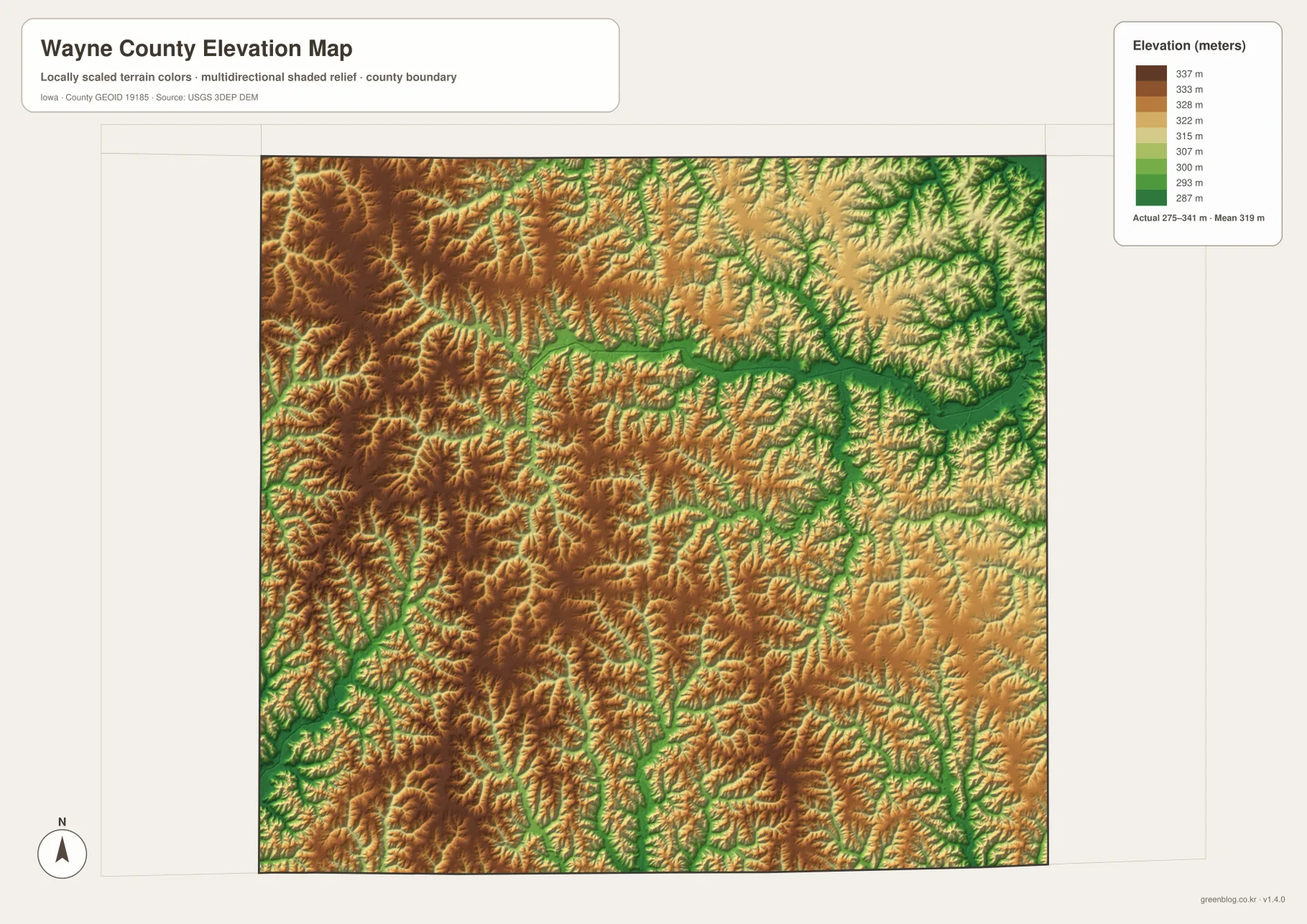
The elevation surface is intended for county-scale comparison rather than parcel-level measurement. It can help explain why streams occupy certain corridors and why neighboring towns can sit in slightly different terrain, but it should not be used for construction, grading, drainage design, or legal surveying. Those tasks require current site-specific data. For general geographic study, however, the elevation map is a useful companion to both the water layer and the road map.
Choose the map by the question you are trying to answer
Use the general county map when the main question is location: where Corydon sits, which way Seymour or Humeston lies, how Iowa 2 crosses the county, or where Lineville meets the southern edge. The city map is better when you want a simple comparison of the six ranked communities and their spacing. Moving between those two layers gives a clear picture of settlement before adding the physical geography underneath it.
For water features, the specialized layer makes South Fork Chariton River, Corydon Lake, Corydon Lagoon, Jackson Creek, and the Medicine Creek branches easier to follow. The elevation map then explains why those streams take the routes they do by showing the lower green valleys and the higher rolling ground between them. Humeston and Millerton relate more closely to the northern drainage system, while Allerton and Lineville sit in the southern uplands. Seymour and Promise City are both eastern communities, but the creek network around them is not identical.
If you need to inspect labels more closely or print a copy, the ZIP below contains the original high-resolution JPG versions of the four maps used on this page. Each JPG is 3638 × 2572 pixels, giving more room for zooming than the web display. The files are useful for personal reference, classroom study, trip preparation, or other situations where a large static map is more convenient than repeatedly switching between small browser images.
Frequently Asked Questions
What is the easiest way to compare Corydon and Seymour?
Start with the general county map. Corydon is near the center where the main east-west and north-south routes meet, while Seymour lies southeast of it. If you also want to understand the land between the two towns, check the water layer for the Jackson Creek area and then compare the same location on the elevation map. Use a current navigation service for live driving distance, road work, and travel time.
Where is South Fork Chariton River within Wayne County?
On the supplied water map, South Fork Chariton River crosses the northern part of the county from west toward east. The elevation layer shows the same corridor as a long area of lower green terrain. Corydon is south of the main river valley and is easier to identify by Corydon Lake, Corydon Lagoon, Iowa 2, and Iowa 14.
Is the 275–341 meter elevation map suitable for surveying or construction?
No. The map is designed to show broad differences between higher uplands and lower stream valleys across the county. It does not provide survey-grade elevations for an individual property. Construction, grading, drainage engineering, road design, and boundary work should use current official or site-specific survey data instead.
Map File Information
The ZIP contains high-resolution JPG files for the Wayne County general, city, water, and elevation maps shown on this page.
- File Type: ZIP containing 4 JPG files
Related Maps
Sources and references
These official sources provide local background and reference information for county boundaries, water features, elevation, and Corydon-area recreation.
- Wayne County, Iowa official website – county government and local information
- Wayne County History – county background and Corydon’s role as the county seat
- City of Corydon: Park Facilities and Activities – Corydon Lake Park and local recreation information
- U.S. Census Bureau TIGER/Line – geographic boundary and transportation data
- USGS National Hydrography – rivers, streams, and water features
- USGS 3D Elevation Program – elevation data
Green Map creates custom-edited map images using open geographic data sources such as geoBoundaries, Natural Earth, OpenStreetMap, and government open data.
These maps are edited visual materials, not raw data files, and are provided for education, documents, presentations, and graphic reference.