Washington County lies in southeastern Iowa, with the city of Washington near the middle of the county and a second cluster of communities across the north around Kalona, Wellman, and Riverside. The maps on this page are designed to show more than a county outline. They place towns and major highways alongside the English River, Iowa River, Skunk River system, smaller creeks, lakes, and the county’s rolling elevation pattern. High-resolution JPG versions of the same four maps are available in one downloadable ZIP for larger viewing or printing.
The Washington County government describes the county as a southeastern Iowa county covering about 556.75 square miles, with a 2020 census population of 22,565. It lists nine incorporated cities: Ainsworth, Brighton, Coppock, Crawfordsville, Kalona, Riverside, Washington, Wellman, and West Chester. On the general map, Washington occupies a central-southern position, while Kalona and Wellman sit across the north, Riverside is near the northeastern edge, Ainsworth lies east of Washington, and Brighton anchors the southwest. That spread gives the county several distinct local centers rather than one continuous urban area.
A useful way to read Washington County is to start with the road network around Washington, then compare the river valleys to the north and south. Iowa 22 connects Wellman, Kalona, and Riverside across the northern part of the county. U.S. 218 follows a north-south route near the eastern side, while Iowa 92 and Iowa 1 help organize travel through the central and southwestern areas. The water and elevation maps reveal a second layer beneath those roads: broad low corridors along the English and Iowa rivers in the north, the Skunk River and Lake Darling area in the southwest, and higher rolling ground between them.
Table of Contents
Roads converge on Washington while northern towns follow Iowa 22
The general county map makes Washington the easiest reference point. Iowa 92 approaches from the west through the West Chester area and reaches Washington, while Iowa 1 comes up from the Brighton direction before continuing through the central part of the county. Roads from Washington extend east toward Ainsworth and the U.S. 218 corridor. Kirkwood Community College’s Washington location is also marked near the city, giving another recognizable landmark around the central road network. For visitors who know the county only by name, this map quickly shows why Washington functions as the main geographic hub.
The northern pattern is different. Iowa 22 runs east-west from the Wellman side through Kalona and toward Riverside, placing three important communities along one broad corridor. Kalona also connects southward toward Washington, while Riverside sits close to U.S. 218 and the Iowa River side of the county. The north edge leads toward Johnson County, and the east side meets the broader Keokuk and Louisa County area. Seeing these roads together helps explain why the north has a more linear chain of towns, whereas the central and southern communities are separated by larger areas of farmland and stream valleys.
Farther south and west, the road network becomes less dense. Brighton is positioned in the southwest near Iowa 1 and Iowa 78, Crawfordsville appears in the southeast, and Coppock is close to the southern boundary. West Chester lies west of Washington along the Iowa 92 corridor. These places are easy to miss on a statewide map, but the county view shows how they relate to Washington and to the routes that cross the county. It also gives a useful frame for the water and elevation maps, where many of the apparently open spaces are broken up by small valleys.
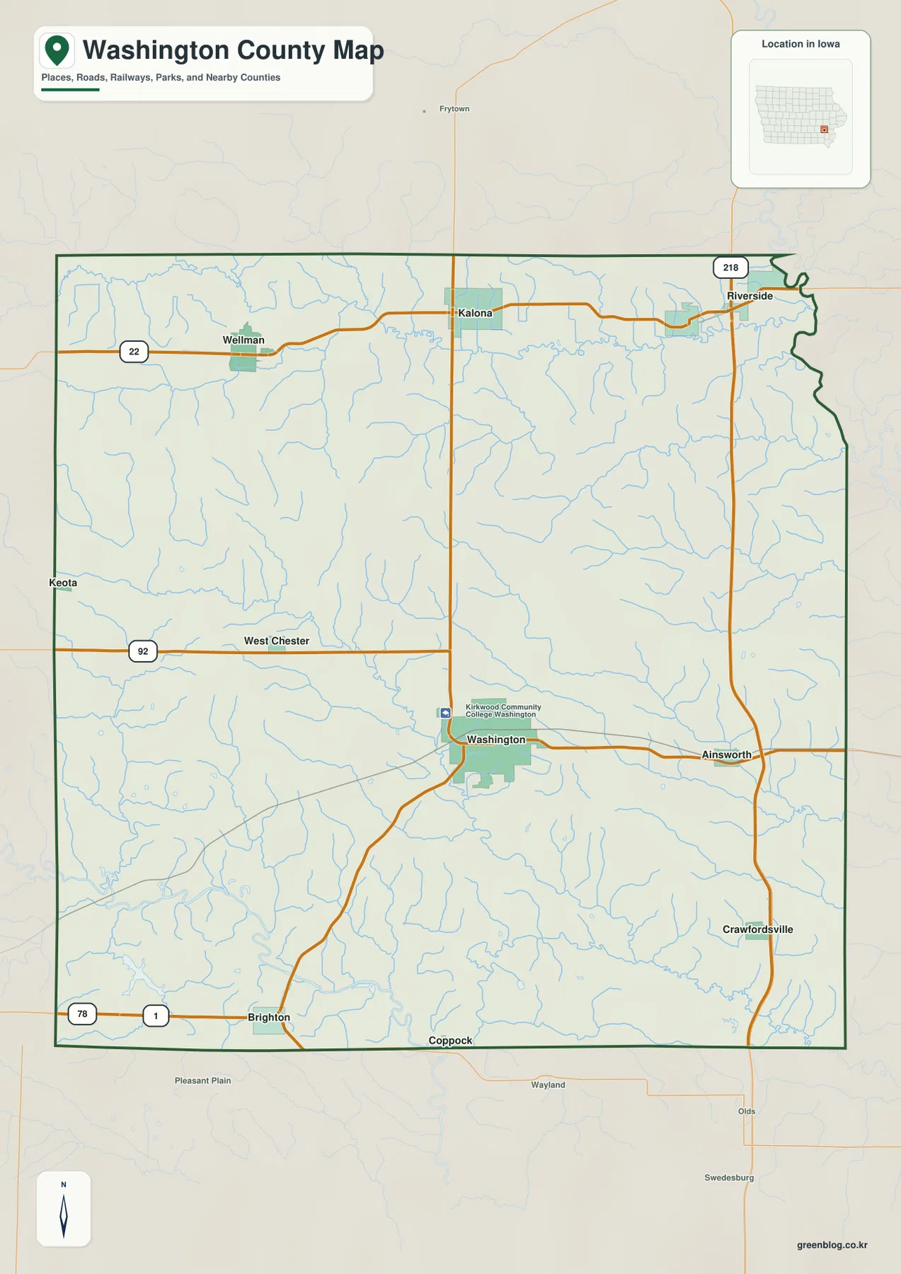
This is a broad geographic reference rather than a parcel or legal-boundary product. It is well suited to locating communities, comparing highways, and matching place names with the other maps on the page. Property lines, construction detours, current road closures, and exact legal boundaries should be checked with the appropriate official source. For most readers, the strongest use of this map is as the base layer: locate the town or highway first, then move to the water or elevation map to see the surrounding landscape.
Six major cities show a northern cluster and a separate southwest center
The city-distribution map ranks six major communities and makes their spacing easy to compare. Washington is shown first near the center-south of the county. Kalona ranks second in the north-central area, Wellman third in the northwest, and Riverside fourth near the northeastern edge. Ainsworth is fifth, east of Washington, while Brighton is sixth in the southwest. The arrangement is useful because it separates the idea of “largest city” from the actual shape of settlement: the main city is central, but several of the next largest communities are grouped across the northern third of the county.
The city index on the supplied map lists Washington at 7,290, Kalona at 2,692, Wellman at 1,454, Riverside at 890, Ainsworth at 633, and Brighton at 588. These figures should be treated as the values used in the map’s own ranking rather than as a promise that they match the latest population estimate. Their practical value is in showing relative scale. Washington is clearly the largest center, Kalona forms a second substantial node, and the remaining communities are smaller places distributed around the county rather than suburbs attached to one continuous urban area.
The northern towns also make more sense when the river map is considered. Kalona and Wellman are close to the English River corridor, while Riverside is near the Iowa River at the northeastern side. Washington and Ainsworth sit farther south, between the northern river lowlands and the Skunk River system. Brighton occupies a different setting again, near the Lake Darling and southern drainage area. This combination of town spacing and river valleys gives Washington County a layered pattern: one central county seat, a northern chain of towns, and smaller communities across the south and east.
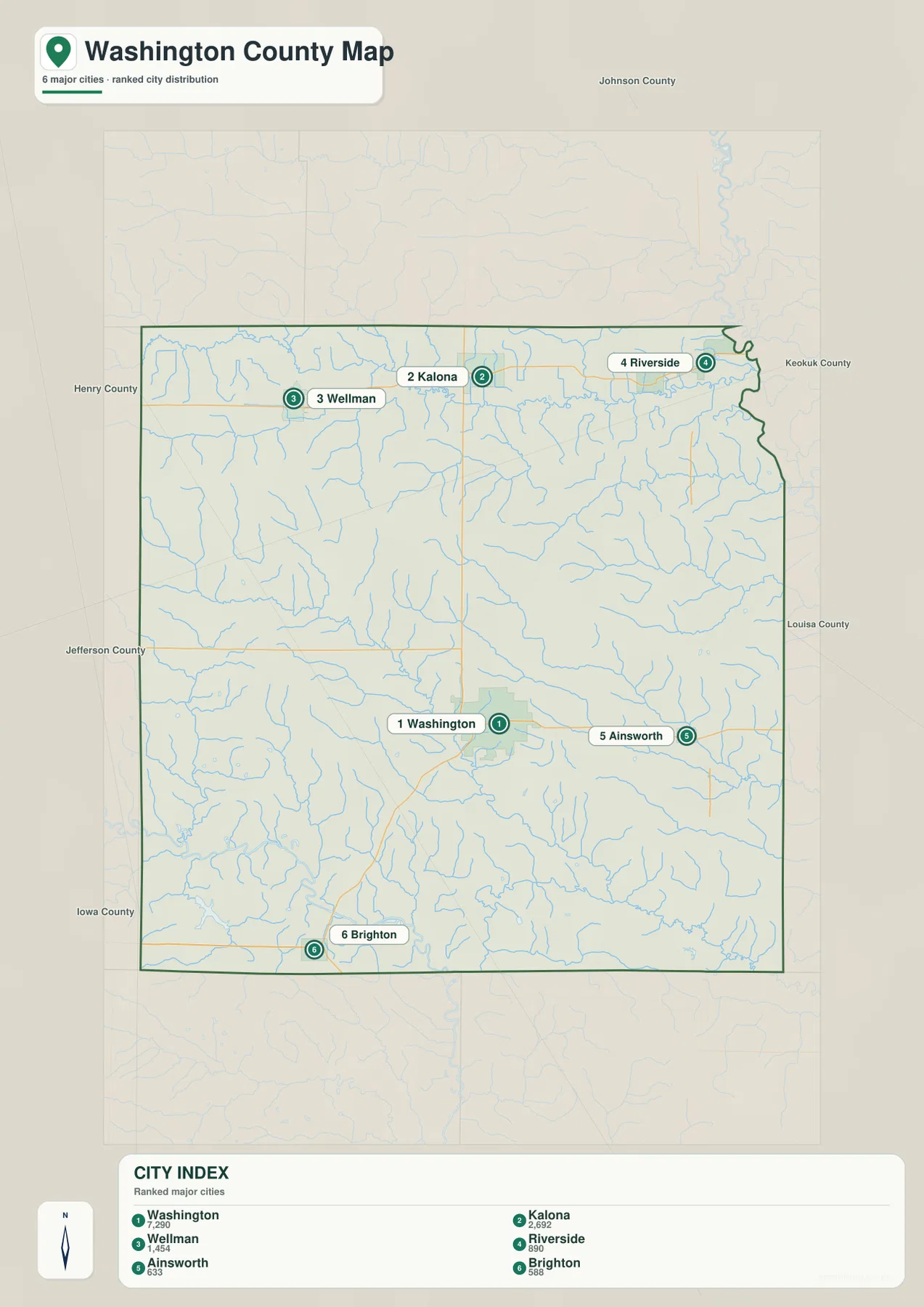
No driving-time or route-distance network is shown on this city map. Two towns that look close in a straight geographic view may require a longer road trip because rivers, local road geometry, and highway access shape the actual route. Use the city layer to understand relative location and scale, then consult a current navigation service for turn-by-turn travel. That distinction is especially important around the river corridors, where a nearby bridge or highway interchange can matter more than straight-line separation.
The English and Iowa rivers define the north; the Skunk River shapes the south
The terrain-and-water map gives Washington County a very different appearance from the road map. The English River runs across the northern portion of the county from west to east and joins the Iowa River near the northeastern side. The Iowa River then forms a major water reference along the east and northeast. This broad northern drainage corridor is one of the county’s most recognizable physical features. It helps explain the low terrain around the northern towns and gives Riverside a particularly clear relationship to the river system.
Smaller named streams divide the central and eastern uplands. Davis Creek crosses the northeast, while North Fork Long Creek and South Fork Long Creek extend through the eastern interior. West Fork Crooked Creek cuts diagonally across the middle of the county, and Goose Creek and East Fork Crooked Creek appear farther south. These waterways are narrow compared with the Iowa River, but together they create a dense drainage network. When the shaded relief is visible behind them, it becomes clear that the creeks occupy small valleys rather than crossing a perfectly flat agricultural surface.
The southern edge is organized by the Skunk River and a group of lakes in the southwest. Lake Darling, Wallrich Lake, Horseshoe Lake, and Sunrise Lake are all labeled on the supplied map. Lake Darling is the most prominent of these landmarks. The Iowa Department of Natural Resources describes Lake Darling State Park in Washington County as a recreation area centered on a 302-acre lake with wooded hills and valleys. On the map, the lake sits southwest of the county’s central uplands and near the lower terrain leading toward the Skunk River, making it a useful landmark for understanding the Brighton side of the county.
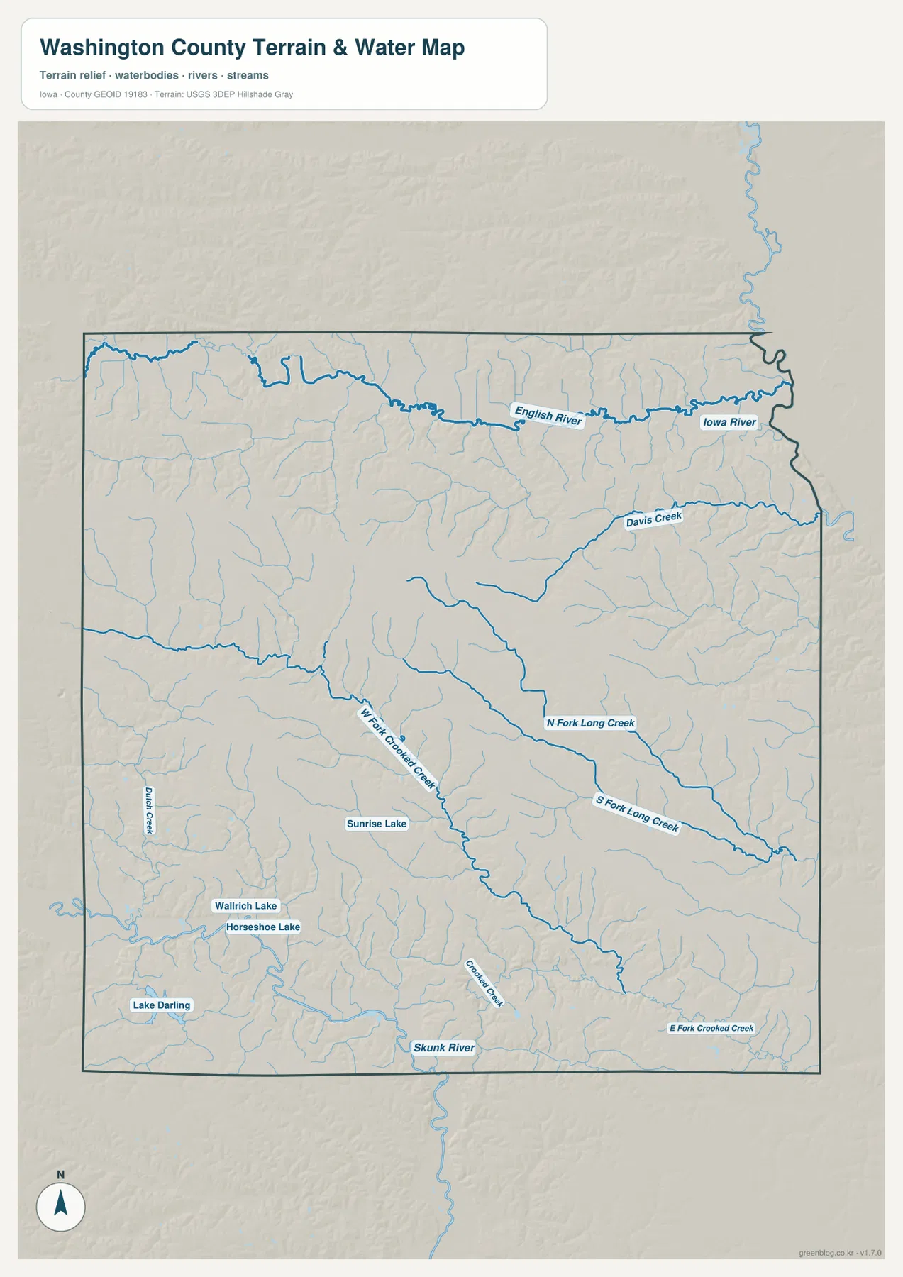
This layer is meant for geographic reference, not floodplain regulation, water-quality decisions, parcel boundaries, or navigation. Flood conditions and lake operations can change, and official agencies should be consulted when a current hazard or recreational condition matters. The map is most useful for seeing how the county is divided by drainage: a broad northern lowland, a southern river corridor, and many smaller valleys crossing the higher interior.
Elevation from about 149 to 251 meters reveals ridges between two low river corridors
The elevation map reports an actual range of about 149 to 251 meters, with a mean near 221 meters. Washington County is not mountainous, yet the shaded surface shows considerable local relief. Low green terrain follows the English River across the north and continues toward the Iowa River. Another broad low zone appears in the southwest and south around Lake Darling and the Skunk River system. Between those two lower corridors, the western and central parts of the county rise into tan and brown rolling uplands.
The central uplands are not one smooth plateau. Numerous narrow green channels cut into the higher ground, matching the creeks seen on the water map. West Fork Crooked Creek, Long Creek branches, and other tributaries create repeated valleys running through the orange and brown ridges. This pattern is especially useful around Washington and Ainsworth, where the road map can make the area look relatively open and even. The elevation layer shows that travel across the county actually crosses a sequence of small ridges and drainage lines.
The southwest provides a strong contrast. Lake Darling and the nearby Skunk River drainage sit in lower green terrain, while higher hills rise around the basin. Brighton is therefore associated with a landscape that is physically different from the English River lowland in the north even though both areas include low valleys. Looking from north to south, the map shows two major low corridors separated by higher rolling ground. That simple pattern is one of the clearest ways to understand the county’s terrain as a whole.
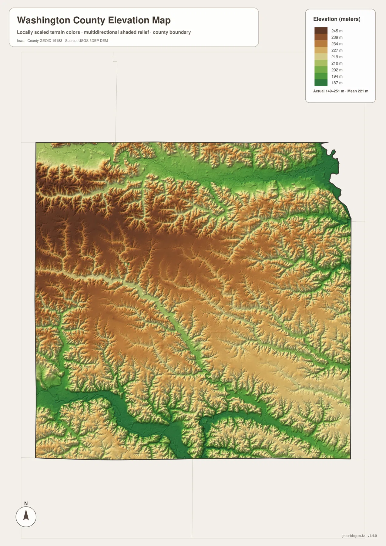
The elevation surface is generalized and should not be treated as a surveyed height for a specific property. It is appropriate for comparing broad ridges, valleys, and drainage relationships across the county. Construction, drainage design, engineering, and parcel-level work require current survey-grade measurements and official site data. On this page, the elevation map works best when paired with the water map, because the green low bands closely follow the rivers and creeks that organize the landscape.
Using the four maps together for Washington, Kalona, Riverside, or Brighton
For Washington, begin with the general map to locate Iowa 92, Iowa 1, Ainsworth to the east, and the surrounding county roads. The water map then shows how many small tributaries cross the central area, while the elevation layer reveals the rolling ridges between them. Washington is therefore more than a dot near the middle of the county: it sits on higher interior ground between the northern English River corridor and the southern Skunk River drainage.
Kalona and Wellman are best understood as part of the northern Iowa 22 corridor close to the English River system. Riverside differs because it sits farther east near U.S. 218 and the Iowa River. Ainsworth serves as an eastern reference between Washington and the highway corridor. Brighton becomes most informative when paired with the Lake Darling and Skunk River maps, where the broad low terrain of the southwest is obvious. Switching among the four layers makes these differences much easier to see than reading a list of place names alone.
The downloadable archive is useful when you want to zoom into labels, keep the maps offline, or print a copy. It contains four original high-resolution JPG files corresponding to the county, city, water, and elevation images shown in the article. The WebP versions on the page are optimized for faster browsing, while the JPG files are better suited to larger viewing. Choose the general or city map for settlements and roads, and use the water and elevation pair when the main question is terrain, drainage, or the relationship between towns and river valleys.
Frequently Asked Questions
Which map best shows the relationship between Washington and Kalona?
Start with the general county map. Washington is near the center-south, while Kalona is north of it along the Iowa 22 corridor. The map also shows Wellman to the northwest, Riverside to the northeast, and the major roads connecting the northern towns with the central county. For actual driving mileage or current travel time, use a live navigation service because this map is intended for geographic orientation rather than route calculation.
What is the main terrain difference between the English River and Skunk River parts of the county?
Both river systems occupy relatively low terrain, but they lie on opposite sides of a broad belt of rolling uplands. The English River creates a long northern lowland leading toward the Iowa River, while the Skunk River and Lake Darling form a second low corridor in the south and southwest. The elevation map makes that separation especially clear because the river valleys are green and the higher interior ridges appear tan and brown.
Can the 149–251 meter elevation map be used for surveying or engineering?
No. The elevation layer is a generalized county-scale surface meant to show relative high and low ground. It is useful for identifying broad ridges, creek valleys, and the relationship between drainage and terrain, but it is not a surveyed elevation source for an individual parcel. Engineering, construction, drainage design, and boundary-related work should rely on official site-specific survey data.
Map File Information
The ZIP contains high-resolution JPG files corresponding to the Washington County general, city, water, and elevation maps shown on this page.
- File Type: ZIP containing 4 JPG files
Related Maps
Sources and references
These official sources provide county background and the boundary, road, water, and elevation information useful for checking the geographic context shown in the maps.
- Washington County, Iowa official website – county area, population, and incorporated-city background
- Washington County Sheriff’s Office – official summary of major highways crossing the county
- Iowa DNR: Lake Darling State Park – official information on Lake Darling and its surrounding hills and valleys
- U.S. Census Bureau TIGER/Line – geographic boundary and transportation data
- USGS National Hydrography – rivers, streams, and water features
- USGS 3D Elevation Program – elevation data
Green Map creates custom-edited map images using open geographic data sources such as geoBoundaries, Natural Earth, OpenStreetMap, and government open data.
These maps are edited visual materials, not raw data files, and are provided for education, documents, presentations, and graphic reference.