Iowa County in east-central Iowa combines a central I-80 corridor with broad river lowlands in the north and a separate network of English River valleys in the south. Williamsburg is the largest highlighted city, while Marengo, Victor, North English, Parnell, and Ladora provide useful reference points across the county. I-80 crosses the central section, U.S. 151 runs through the eastern side near the Amana area, U.S. 6 provides a western reference around Victor and Ladora, and Iowa 149 reaches North English in the south. This page explains the supplied county, city, terrain-and-water, and elevation maps, and high-resolution JPG versions can be downloaded in a ZIP near the end of the article. High-resolution map files are available for download in the section below.
The easiest way to orient the county is to start with Williamsburg near the center and Marengo to the northwest. Williamsburg is close to I-80, while Marengo lies nearer the broad Iowa River lowland. Victor and Ladora help locate the west, and North English and Parnell anchor the south. The elevation map makes the terrain pattern easy to see because the Iowa River and English River systems appear as lower green corridors separated by higher rolling ground.
Table of Contents
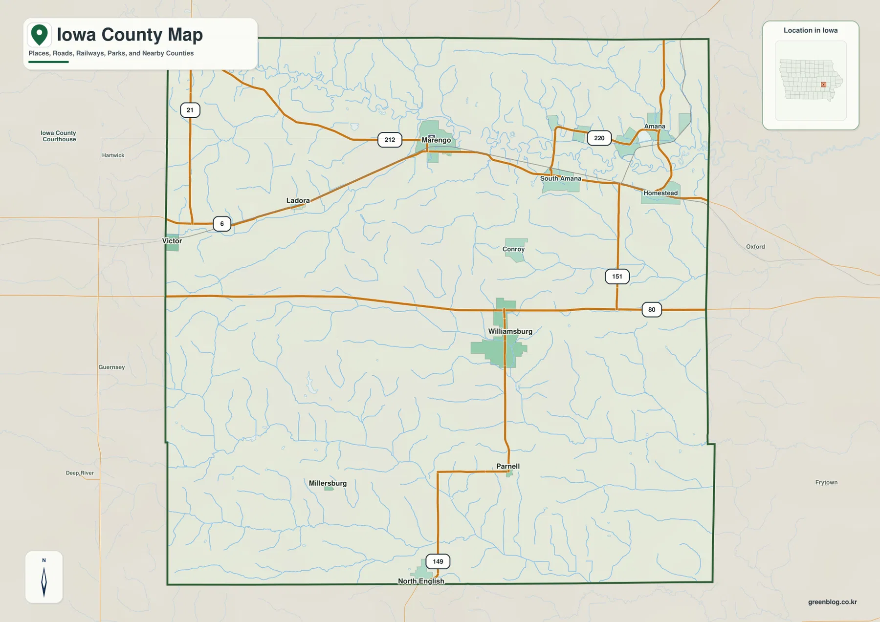
Williamsburg and I-80 organize the central road network
Williamsburg is the strongest first landmark on the general county map. I-80 crosses the county east-west just north of the city, while local north-south roads connect Williamsburg with Parnell and North English. On the eastern side, U.S. 151 runs near the Amana and South Amana area. Homestead and Conroy provide additional place references between the main corridors.
Victor and Ladora are shown in the west near U.S. 6, and Marengo lies farther northeast. Amana and South Amana mark the northeastern section, while Millersburg and North English help define the south. The general county map is intended for broad geographic orientation rather than live navigation, so current construction, closures, and exact access points should be checked with current transportation information.
The roads are mostly straight, but the river network is not. Iowa River bends across the northern lowlands, while the English River system crosses the southern half in several branches. Comparing the road map with the water map reveals why a county that looks simple from its highways contains a much more varied natural landscape.
Williamsburg and Marengo lead the six-city ranking
The city map ranks Williamsburg first with a mapped population of 3,360 and Marengo second at 2,725. Victor is third at 987, North English fourth at 582, Parnell fifth at 303, and Ladora sixth at 240. The six communities are spread across the center, northwest, west, and south rather than clustered into one continuous urban area.
Williamsburg provides the central reference, while Marengo is useful for the northern side and Victor and Ladora for the west. North English and Parnell help locate the southern half. Neighboring counties labeled around the map include Benton, Linn, Johnson, Tama, Keokuk, Washington, and Poweshiek, placing Iowa County within a broad east-central Iowa context.
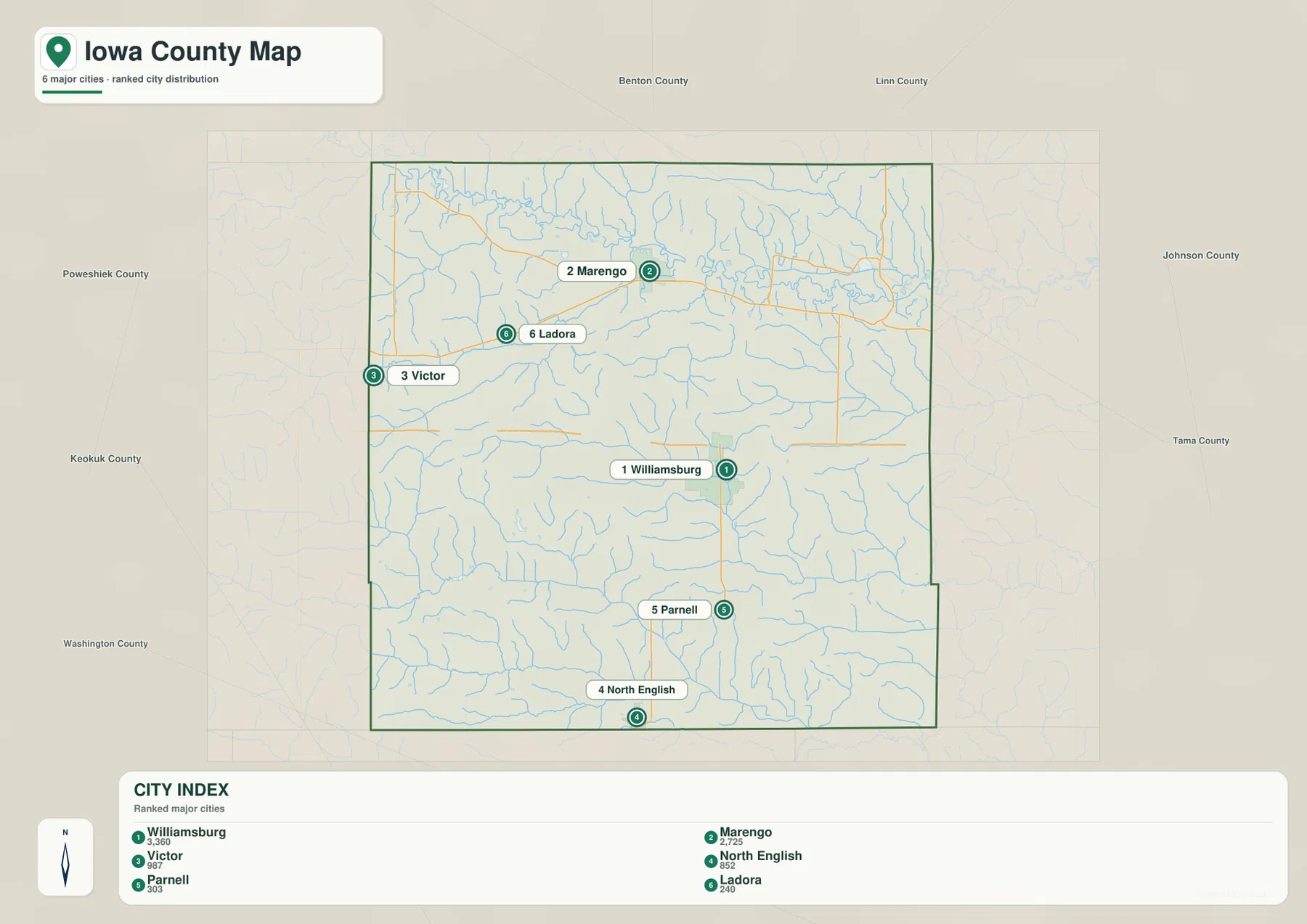
The town pattern becomes more meaningful when it is compared with elevation. Marengo and the Amana side of the county are close to the broad Iowa River lowland, while Williamsburg occupies higher rolling terrain farther south. Victor and the western interior contain many ridges, and North English and Parnell sit near the southern English River drainage network.
Iowa River forms the broad northern lowland
Iowa River is the dominant waterway across the northern side of the terrain-and-water map. It enters from the northwest, winds eastward through a broad low corridor, and continues beyond the county. On the elevation map, the same route appears as a wide dark-green band, making the river valley easy to distinguish from the higher rolling ground to the south.
Price Creek is labeled in the northeast, while Middle Pond, Lily Pond, and Holdens Pond appear close to the Iowa River side of the county. South Amana Pond is shown farther south of the river. These smaller water features help locate the Amana-area lowlands and show that the northern river corridor includes more than the main channel alone.
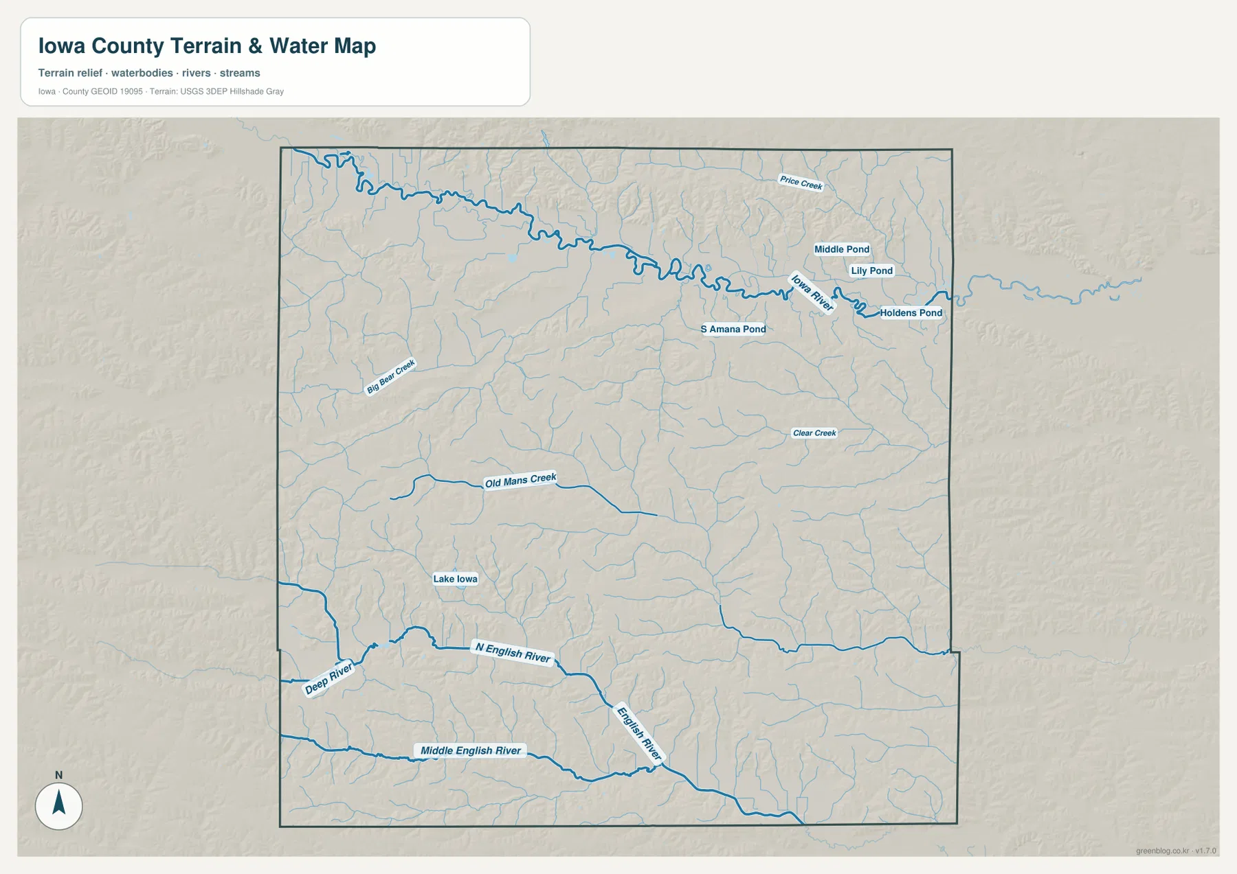
This sheet is intended for geographic reference rather than flood forecasting, current water levels, navigation, parcel boundaries, or legal water limits. Its main value is showing how the major river corridors and smaller water features fit around the county’s towns and roads.
English River branches divide the southern uplands
The southern half of Iowa County is defined by the North English River, English River, and Middle English River. North English River crosses from west to east and joins the broader drainage system near the central-southern area. Middle English River runs farther south, while English River forms a connecting corridor between the branches. Together, the three waterways create a series of long lower valleys through the rolling uplands.
Old Mans Creek runs across the west-central interior, and Clear Creek is labeled farther east. Big Bear Creek appears in the western section, while Lake Iowa provides an easy water reference in the southwest-central area. These features explain the dense network of green valleys on the elevation map and show why the southern landscape is much more dissected than the road grid suggests.
North English and Parnell are useful settlement references for the southern drainage country. Moving south from Williamsburg, the terrain becomes increasingly cut by small tributaries before reaching the larger English River corridors. Pairing the town labels with the waterways makes the geography easier to remember than studying the stream names separately.
Elevation ranges from 207 to 287 meters
The supplied elevation map shows an actual county range of about 207 to 287 meters, with a mean elevation of 249 meters. The broadest low terrain follows Iowa River in the north, while another series of green lowlands follows the English River system in the south. Higher tan, orange, and brown ground occupies much of the central and western interior between those river corridors.
The northern Iowa River lowland is broad and relatively continuous. The central uplands are more broken, with short tributaries carving narrow green fingers into the higher surface. In the south, North English River and Middle English River create long lower corridors separated by narrow ridges. The eastern side contains several converging valleys, producing a complex relief pattern despite the county’s modest overall elevation range.
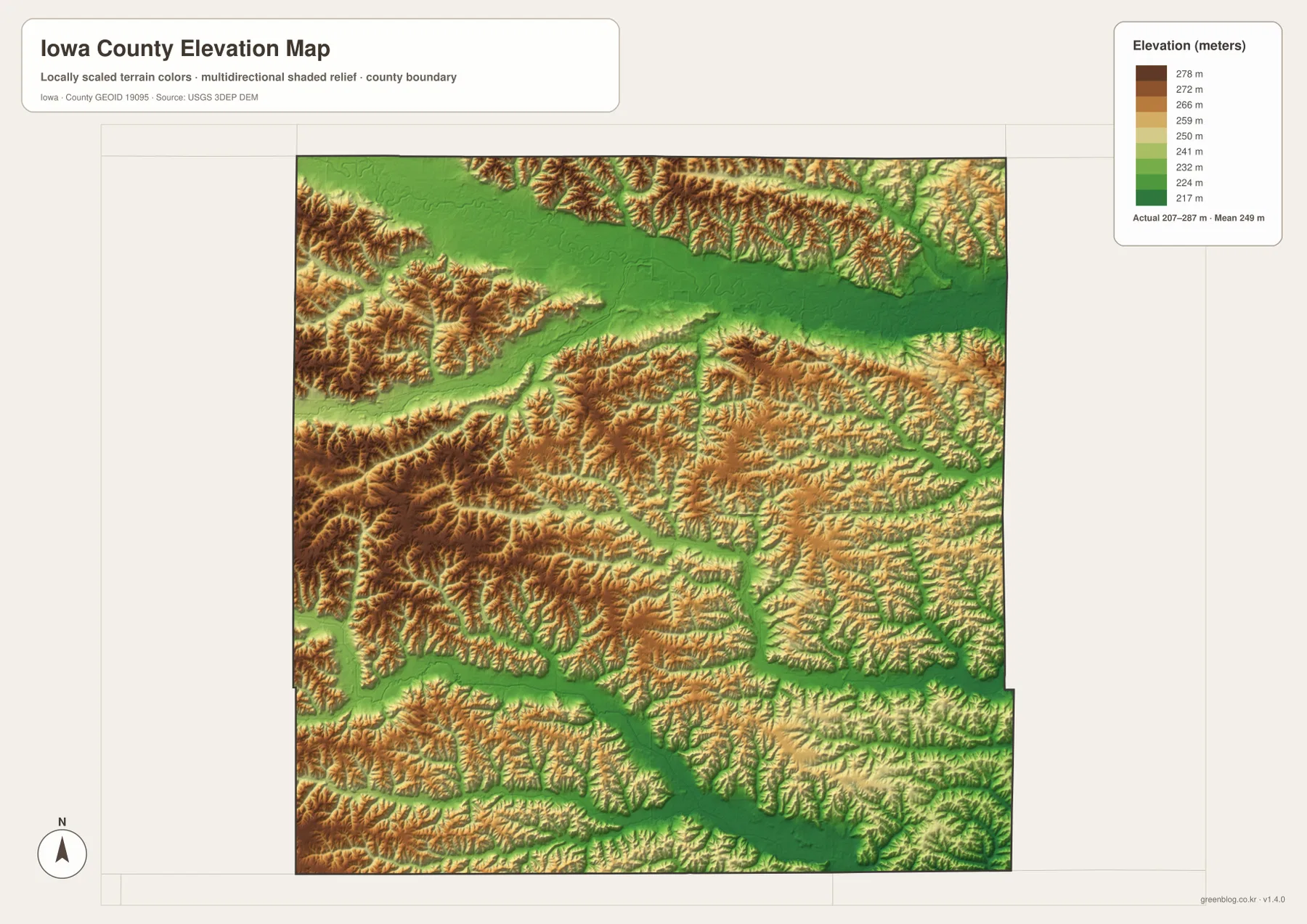
The elevation colors are designed for broad terrain comparison rather than survey-grade measurement. Exact parcel elevation, road grade, engineering design, or construction work requires original elevation data or professional surveying. For general map reading, the important pattern is the contrast between the northern and southern river valleys and the higher rolling ground between them.
Straight highways and winding rivers reveal different county patterns
Iowa County’s general map is easy to orient with I-80, U.S. 151, U.S. 6, and Iowa 149, but the natural landscape follows very different lines. Iowa River curves through the north, and the English River branches cross the south in long, irregular corridors. Williamsburg is the best central road reference, while Marengo, North English, and the Amana area help connect the road map with the terrain map.
Victor and Ladora are useful for the western uplands, North English and Parnell for the southern valleys, and Marengo for the northern lowlands. Using those local anchors makes it easier to move between the county, city, water, and elevation maps without treating them as separate topics.
Choose the Iowa County map that fits the task
Use the general county map when you need towns and numbered roads in one view. It is the quickest way to compare Williamsburg, Marengo, Victor, North English, and the Amana area with I-80, U.S. 151, U.S. 6, and Iowa 149. The city map is better when the goal is to compare the six highlighted communities and the population ranking shown on the supplied graphic.
The terrain-and-water map is best for Iowa River, North English River, English River, Middle English River, Old Mans Creek, Clear Creek, Lake Iowa, and the mapped ponds. The elevation map adds the 207–287 m range and makes the northern and southern lowlands and higher central uplands immediately visible.
The WebP images in the article are optimized for quick browser viewing. For printing, classroom use, presentations, or closer comparison, the ZIP below contains the county, major-city, terrain-and-water, and elevation maps as high-resolution JPG files. They are general-reference graphics and do not replace legal boundary records, current transportation data, flood information, or precise survey measurements.
Frequently Asked Questions
Which map is best for locating Williamsburg and Marengo?
The general county map is the best starting point. Williamsburg is near the center and close to I-80, while Marengo lies farther northwest near the Iowa River lowland. Victor, Ladora, North English, U.S. 151, U.S. 6, and Iowa 149 are also labeled on the same sheet.
What are the main rivers and water features shown in Iowa County?
Iowa River dominates the north, while North English River, English River, and Middle English River divide the south. Old Mans Creek and Clear Creek are also prominent, and Lake Iowa plus several ponds are labeled on the water map.
What does the 207–287 m elevation range show?
The elevation map shows broad low terrain along Iowa River and another set of low valleys along the English River system, with higher rolling ground between them. The mapped mean elevation is 249 meters. Precise site elevations require original elevation data or professional survey information.
Map File Information
The ZIP contains four high-resolution JPG maps for Iowa County, Iowa: county, major cities, terrain and water, and elevation.
- Included Files: Use only the versions confirmed in the article and supplied images
- File Type: Use the confirmed download contents
- Intended Use: Printing, education, presentations, and map-based projects
Related Maps
Sources and reference data
The links below provide authoritative U.S. government source data for county boundaries, hydrography, and elevation represented in the supplied map set.
These maps are intended for general geographic reference, learning, printing, and visual comparison. Legal boundaries, ownership, current road conditions, flood risk, water levels, and precise elevations should be checked against the responsible agency’s current records.
Green Map creates custom-edited map images using open geographic data sources such as geoBoundaries, Natural Earth, OpenStreetMap, and government open data.
These maps are edited visual materials, not raw data files, and are provided for education, documents, presentations, and graphic reference.