DeKalb County in northeastern Indiana is centered on Auburn, with I-69 running north toward Waterloo and Ashley and US 6 crossing the northern half toward Butler. You can download the four DeKalb County maps on this page as high-resolution JPG files in one ZIP archive. Garrett lies just west of Auburn, while Hamilton, St. Joe, Spencerville, Corunna, and Altona help fill out the rest of the county. The sections below use the county, city-distribution, water-and-terrain, and elevation maps to explain how these places, waterways, and changes in height fit together.
The maps reveal a county that is easy to orient once a few landmarks are fixed in mind. Auburn and Garrett create a close western pair, Waterloo sits farther north, and Butler occupies a separate position to the east. Cedar Creek runs through the central-western part of the county, while the St. Joseph River appears in the southeast and Fish Creek stands out near the northeast edge. The elevation map adds another layer: the highest colors are concentrated toward the northwest and north, while lower green terrain spreads across much of the southeast.
That combination makes DeKalb County useful for comparing human and physical geography on the same page. The road map is best for locating towns and highways, the city index strips away most of the road detail to make settlement spacing clearer, the water map highlights creeks, rivers, lakes, and ditches, and the elevation map shows a real range of about 233 to 322 meters with a mean near 270 meters. None of the maps is intended to replace navigation, surveying, flood mapping, or engineering data, but together they provide a practical county-scale overview.
Table of Contents
Auburn and I-69 make the fastest starting point
On the county map, Auburn is the most prominent urban area in the southern half of DeKalb County. I-69 passes just to its west, and State Road 8 extends eastward from the Auburn area toward the eastern side of the county. Garrett is close to Auburn on the west, with Altona a little farther northwest. This cluster is visually distinct from the towns in the north and east, so Auburn works well as an anchor before trying to follow every road number on the map.
North of Auburn, Waterloo sits where the road pattern becomes especially useful for orientation. US 6 runs east-west through Waterloo toward Corunna on one side and Butler on the other, while I-69 remains nearby to the west. Ashley appears farther north close to the interstate corridor, and State Road 427 angles northeast from the Waterloo area toward Hamilton. Rather than reading the map as a long list of highways, it is easier to remember I-69 as the main north-south reference and US 6 as the northern east-west reference.
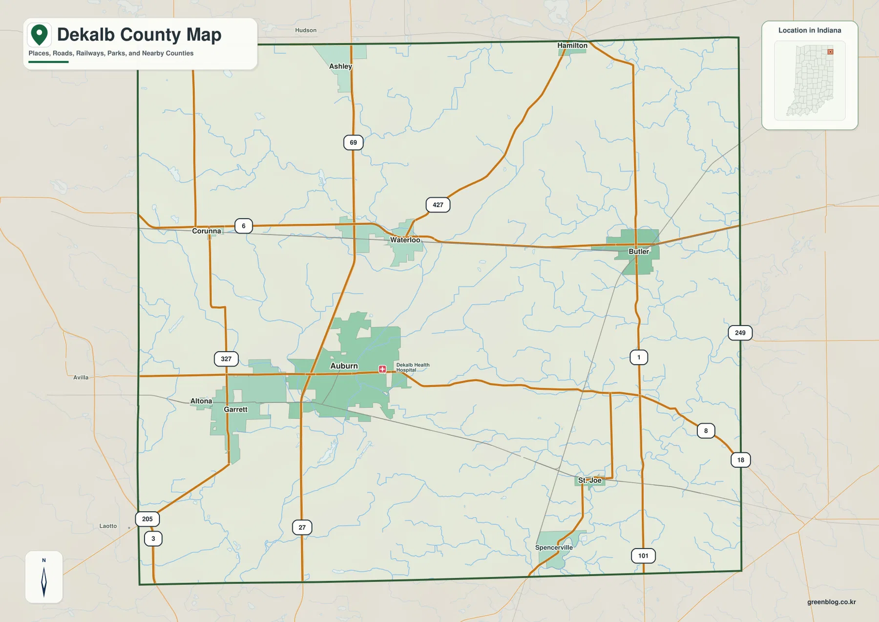
The eastern and southeastern parts of the county have a different road pattern. Butler is the strongest city label in the east, with State Road 1 running north-south through the area. State Road 8 links the Auburn side of the county toward the east, while St. Joe and Spencerville appear farther south near State Road 101. Hamilton is separated from the Auburn-Garrett cluster in the north-central to northeastern part of the map. These places are important because they show how much of DeKalb County lies beyond the immediate I-69 corridor.
This is a county reference map, not a live driving map. It does not show current construction, lane closures, turn restrictions, travel times, or every local road condition. For trip planning, the best use is to identify the broad direction of a destination and then check a current navigation or transportation source for the final route.
The city index separates the western cluster from Butler and Ashley
The city-distribution map removes much of the road detail and ranks six major places shown in the supplied index. Auburn is marked first, followed by Garrett, Butler, Waterloo, Ashley, and Altona. Those numbers are useful as a map index, but they should not be treated as a permanent statement of civic importance. Anyone who needs current population or legal municipal boundaries should consult the appropriate government statistics and local records.
What the city map does particularly well is reveal spacing. Auburn and Garrett sit close together in the southwest-central part of the county, with Altona just to the west. Waterloo is clearly north of Auburn, and Ashley lies farther north again. Butler breaks away to the east, making the county’s east-west span much more obvious than it appears when the full road network is visible. The pattern also explains why US 6 is such a useful line on the general map: it links the Waterloo area with Butler across the upper half of the county.
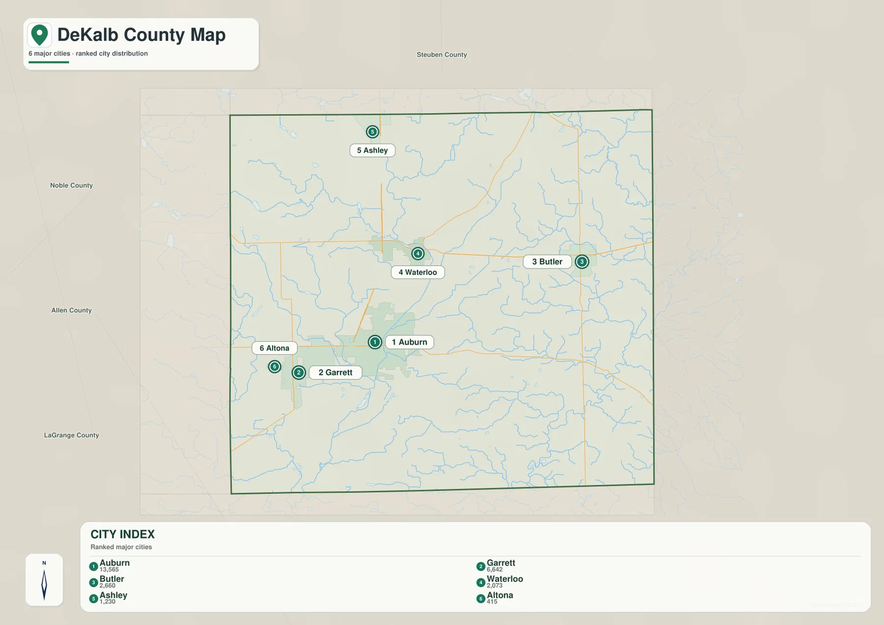
Several labels visible on the county map do not appear in this six-place index, including Hamilton, St. Joe, Spencerville, and Corunna. That is why the city map works best as a companion rather than a replacement for the full reference map. Use the index to understand the larger settlement pattern, then return to the road map for the smaller places and the roads that connect them.
Cedar Creek and the St. Joseph River show two different water settings
Cedar Creek is the strongest water reference in the central-western part of the terrain-and-water map. It extends southward from the Cedar Lake area and continues toward the southern side of the county, with smaller streams branching into the same general area. Little Cedar Creek and Black Creek are labeled in the southwest. When these water features are compared with the road map, the Auburn side of the county becomes easier to place without relying only on highways.
The southeast looks different. The St. Joseph River curves through the lower-right part of the map, and Bear Creek joins the same general river corridor. Fish Creek is prominent near the northeast edge, while Metcalf Ditch appears in the east-central area. These named waters show that DeKalb County does not drain visually toward one single channel across the entire map. Different parts of the county are organized around different streams and low corridors.
The smaller lakes provide useful checkpoints. Upper Story Lake appears in the northwest, Indian Lake, Lintz Lake, and Haynes Lake are visible in the western half, Cedar Lake is near the upper part of Cedar Creek, and Dunton Lake sits close to the southern edge. They are not large enough to dominate the county map, but on the water map they help identify local areas when creek names alone are difficult to follow.
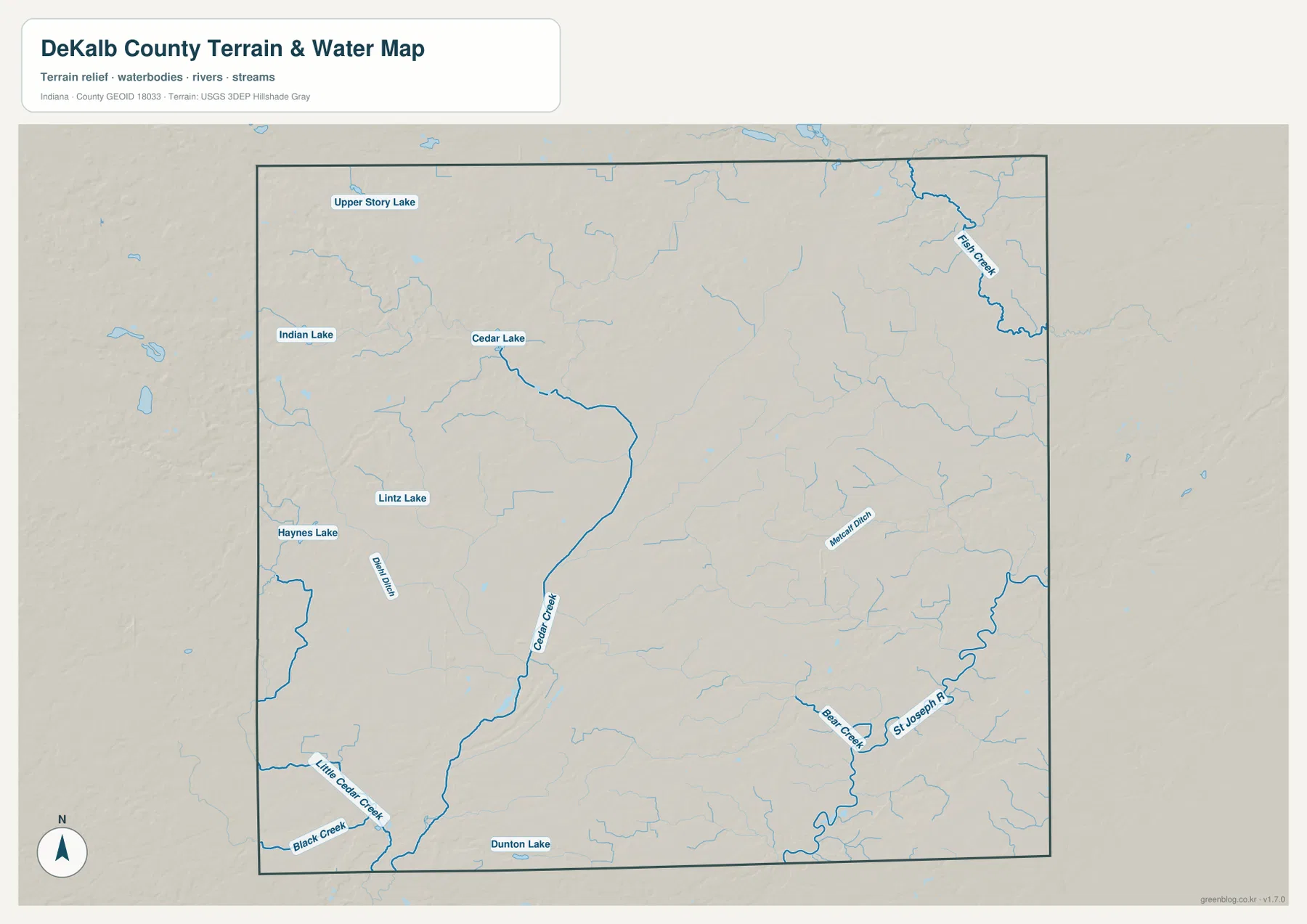
This water map is designed for geographic reference. A bold blue line does not indicate a specific flow rate, flood hazard, legal water boundary, or navigable channel. Flood insurance decisions, drainage permits, water-quality questions, and property work require current information from the responsible agencies. Here, the map is most useful for comparing where the named waterways sit relative to towns and terrain.
Elevation falls from the northwest toward the southeast
The elevation map gives DeKalb County a clear directional contrast. The legend reports an actual range of roughly 233 to 322 meters and a mean around 270 meters. Browns and darker oranges cover much of the northwest and parts of the northern edge, marking the higher ground. Colors become lighter through the center and turn increasingly green toward the east and southeast, where the lowest broad areas are concentrated.
The change is gradual rather than mountainous. The northwest is made up of higher rolling land crossed by shallow low corridors, while creek valleys cut through the middle of the county. Cedar Creek corresponds with a lower route through the western-central area, and the southeast contains more green lowland around the St. Joseph River and nearby tributaries. Looking back and forth between the water and elevation maps makes these connections much easier to see than reading the color scale by itself.
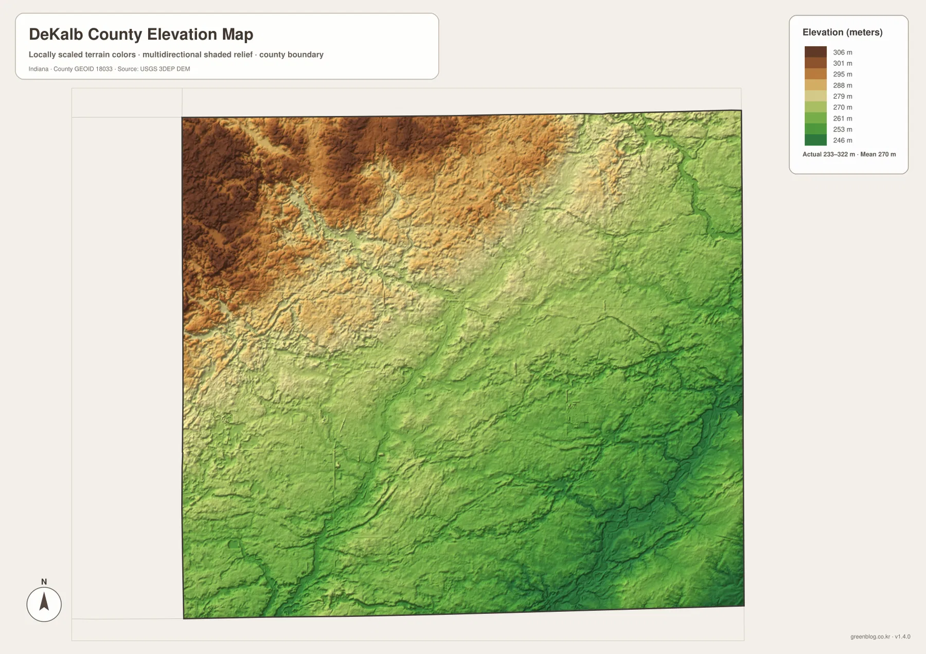
The map should not be used as a survey or engineering surface. Elevation can vary within a single color band, and small features such as road embankments, ditches, and individual building sites may be too small to appear clearly at county scale. For property design, construction, drainage, or precise grade calculations, use survey-grade measurements and the latest official elevation products.
Choose the map by the question you need to answer
For a first look at DeKalb County, start with Auburn and I-69 on the general map. From there, move north to Waterloo and Ashley, east to Butler, and west to Garrett. If the highway labels feel busy, switch to the city-distribution map and use the simpler settlement pattern before returning to the full road map. That two-step approach is especially helpful when comparing the close Auburn-Garrett pair with the more distant eastern side of the county.
For natural features, pair the water map with the elevation map. Find Cedar Creek or the St. Joseph River first, then locate the same part of the county on the elevation colors. Creek corridors generally appear in lower terrain, while the broad northwest stands higher. The relationship is visible enough to explain the county’s overall shape, but the maps do not provide parcel-level drainage or exact slope measurements.
The WebP images in the article are sized for quick online viewing. The download below contains the original high-resolution JPG versions of the county reference map, city-distribution map, terrain-and-water map, and elevation map. Each JPG is 3638 × 2572 pixels, making the files more useful for zooming, printing, classroom use, and offline reference. They remain general-reference maps rather than legal, survey, flood, or engineering products.
Official county sources add local context to the map
Indiana’s county directory identifies Auburn as the county seat and lists communities including Altona, Ashley, Auburn, Butler, Garrett, Hamilton, St. Joe, Spencerville, and Waterloo. Those names closely match the places visible on the supplied county map. The state directory helps confirm the administrative and community context, while the map itself is better suited to showing where those places sit relative to one another.
DeKalb County Government provides county offices and services from Auburn, and Visit DeKalb’s local guide covers Auburn, Garrett, Waterloo, Butler, Hamilton, Ashley, St. Joe, Spencerville, and Corunna. Those resources are useful for current local information and trip planning. The maps on this page serve a different purpose: they bring roads, settlement positions, waterways, and elevation together so a reader can understand the county before opening more detailed local sources.
Frequently Asked Questions
Which map is best for comparing Auburn, Garrett, Waterloo, and Butler?
Use the city-distribution map first because it removes most road detail and makes the spacing between the main places easy to see. Auburn and Garrett are close together in the west, Waterloo is farther north, and Butler stands apart in the east. Then return to the county map to add I-69, US 6, State Road 8, and the other road connections.
Where is the strongest elevation contrast in DeKalb County?
The broadest contrast is between the higher northwest and the lower east and southeast. The elevation map spans about 233–322 meters with a mean near 270 meters. Lower green corridors also follow parts of the creek and river network, including the southeast around the St. Joseph River.
What files are included in the DeKalb County map download?
The ZIP contains high-resolution JPG versions of the county reference map, city-distribution map, terrain-and-water map, and elevation map. Each file is 3638 × 2572 pixels. They are suitable for zooming, printing, and general reference, but they are not substitutes for legal boundary, surveying, flood-hazard, or engineering data.
Map File Information
Download the DeKalb County reference, city-distribution, terrain-and-water, and elevation maps as high-resolution JPG files for closer viewing, printing, and offline reference.
- File Type: JPG
Related Maps
Sources and References
- DeKalb County Government, Indiana — county offices and Auburn government information
- Indiana Counties — DeKalb County seat and city/town directory
- Visit DeKalb — local community and visitor information for Auburn and surrounding towns
- U.S. Census Bureau TIGER/Line Shapefiles — county boundaries, roads, and place data
- USGS National Hydrography — rivers, streams, lakes, and hydrography data
- USGS 3D Elevation Program — elevation and terrain data
Green Map creates custom-edited map images using open geographic data sources such as geoBoundaries, Natural Earth, OpenStreetMap, and government open data.
These maps are edited visual materials, not raw data files, and are provided for education, documents, presentations, and graphic reference.