Decatur County sits in southeastern Indiana with Greensburg near the center of the road network and smaller communities spread toward several edges of the county. The general map makes I-74, U.S. 421, State Road 3, and State Road 46 useful orientation lines, while the terrain-and-water map separates the Flatrock River system in the northwest from the Vernon Fork Muscatatuck River side of the southeast. This page explains those road, settlement, water, and terrain relationships and also provides the high-resolution JPG map files as a ZIP download.
Greensburg is the easiest place to start because the other labeled communities form a broad ring around it. St. Paul lies to the northwest, Westport is well to the southwest, Millhousen sits near the southeastern side, and New Point is east of Greensburg. The city-connections map strips away much of the road detail so those directions are easy to remember. Returning to the general map then shows how the highways and state roads reach the same places without forcing the reader to memorize a long list of route numbers.
The land surface adds another strong east-west contrast. The elevation map reports an actual range of about 212 to 334 meters and a mean near 275 meters. Broad green lowlands occupy much of the west and southwest, while orange and brown uplands become dominant toward the east and northeast. Narrow stream valleys cut back into that higher ground, so the county does not rise as one smooth slope. The water and elevation maps are especially useful together because the lower channels help explain the branching pattern of creeks across the interior.
Table of Contents
Greensburg turns the road map into a simple set of directions
On the general county map, Greensburg is the most prominent built-up area and the point where several major routes become easy to compare. I-74 approaches from the northwest, passes the Greensburg area, and continues toward the eastern side of the county. U.S. 421 also links the northwest with the central part of the map. State Road 3 gives a clear southbound reference toward Westport, while State Road 46 points east toward New Point. Those four routes provide a practical framework for reading the rest of the county without treating the map like a turn-by-turn navigation screen.
Northwest of Greensburg, St. Paul appears close to the county edge with smaller place labels such as St. Omer and Adams nearby. That corner feels much more open than the Greensburg area because settlements are separated by longer rural stretches. East of the hub, New Point sits on a clear east-west route and helps define the county’s eastern side. Clarksburg and the Lake Santee label farther north provide additional reference points for the northeast, even when the reader is not traveling directly to those places.
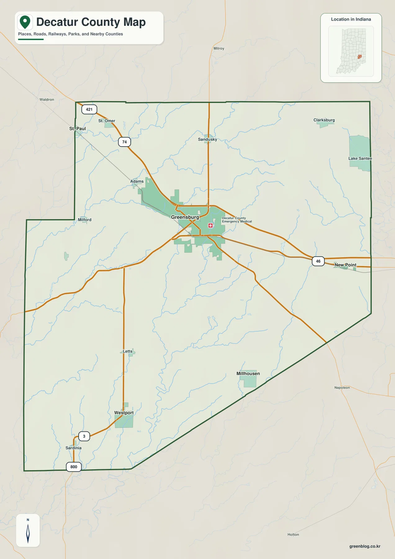
The southwestern projection of the county is useful for recognizing Westport. State Road 3 runs south from the Greensburg area through this longer section, with Letts and Westport providing intermediate location cues. Millhousen is not on the same southbound line; it is farther east near the diagonal southeastern boundary. That distinction matters when a quick glance makes both communities look simply “south of Greensburg.” One is southwest on a pronounced north-south route, while the other belongs to the hillier southeastern side.
This general map is intended for county-scale orientation. It does not show current construction, lane restrictions, exact travel times, or driveway-level access. Use it to understand where roads and communities sit in relation to one another, then consult a current navigation or transportation service for a real trip. The map is most effective when it answers broad questions such as which side of the county a town occupies or which main route provides the nearest reference.
Four outer communities show how widely Decatur County spreads around Greensburg
The city-connections map reduces the county to five labeled communities: Greensburg as the hub, plus Westport, St. Paul, Millhousen, and New Point. Their placement is more informative than a simple ranked list because each occupies a different direction. St. Paul marks the northwest, Westport the southwest, Millhousen the southeast, and New Point the east. With the road clutter removed, it becomes obvious that Decatur County does not have a single north-south chain of towns or one continuous urban corridor.
The connecting lines use direct distance from Greensburg rather than road mileage. That is important when comparing the four communities. A straight line can cross terrain, streams, and roads that a vehicle cannot follow directly, so the printed mileage should not be used as a driving estimate. The value of the graphic is the geometry. It shows which places are nearer or farther from Greensburg in a simple county-wide view, making the different directions easier to remember before returning to the full road map.
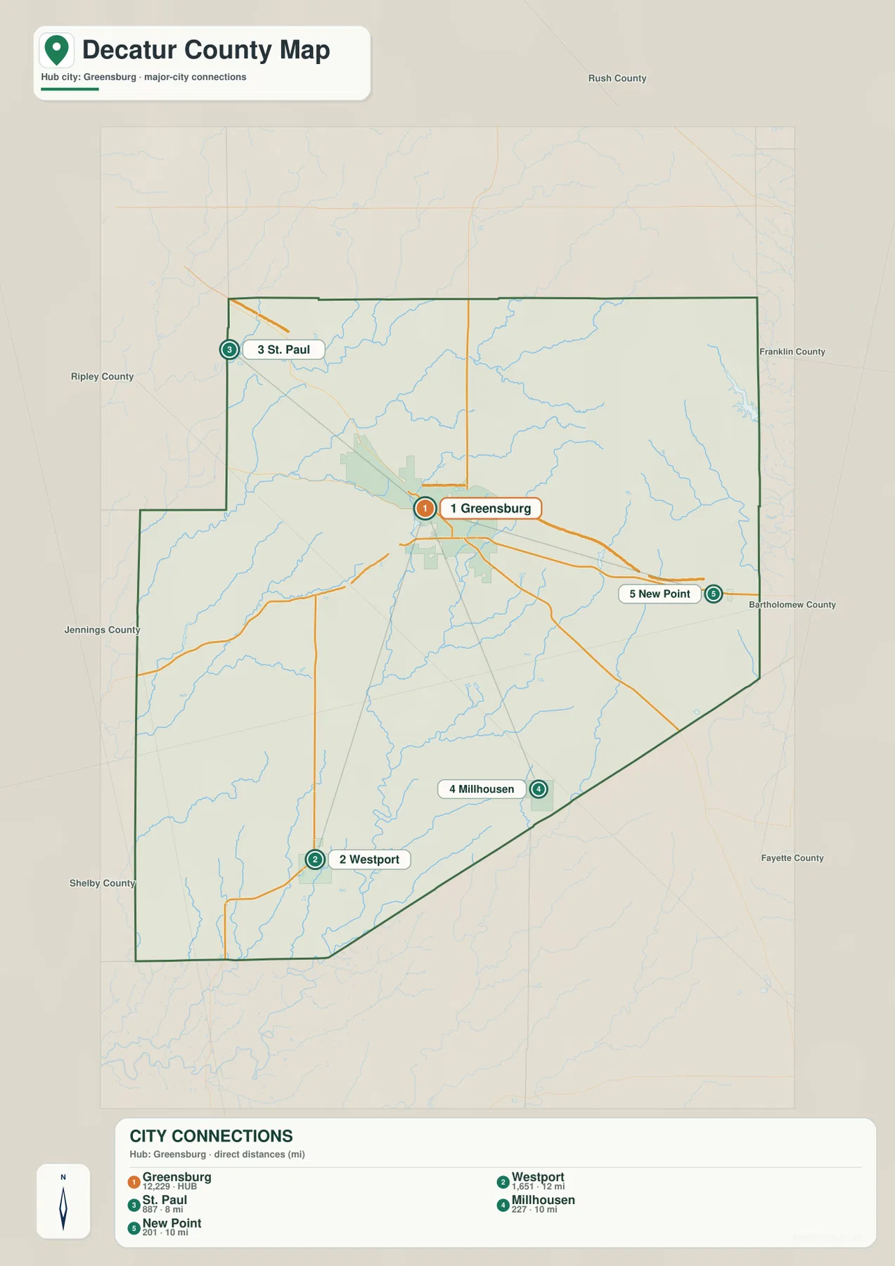
Visit Greensburg’s local guide lists the same core set of incorporated communities: the City of Greensburg and the towns of Millhousen, New Point, Saint Paul, and Westport. That makes the city map a useful bridge between a visitor-oriented list of local places and the county’s actual geography. It should not be treated as a municipal-boundary map, however. The symbols show community locations, not precise city or town limits, and they do not establish whether an individual property lies inside an incorporated boundary.
Flatrock waterways in the northwest give way to a different southeastern drainage pattern
The terrain-and-water map gives the northwest corner a distinct identity. Flatrock River and Little Flatrock River are the largest named water features there, and Clifty Creek extends through the western side. The shaded relief around those channels is comparatively broad and gentle, matching the lower elevations seen on the separate elevation map. Rather than appearing as isolated blue lines, the streams occupy visible low corridors that make the relationship between water and terrain easier to follow.
The center of the county contains a more intricate set of creek valleys. Sand Creek is a strong reference in the central-southern area, while Middle Fork and Cobb Fork occupy nearby channels. Small tributaries branch repeatedly between them. Middle Fork Lake on the western side and Lake McCoy farther east provide fixed water landmarks that are easier to spot than many of the smaller creek names. Using those lakes as checkpoints can help a reader reorient after following several branching streams.
Farther southeast, Vernon Fork Muscatatuck River becomes one of the clearest named channels. Cobb Fork approaches that side of the county, while Salt Creek and other short tributaries appear farther east. The surrounding relief is steeper than in much of the west, so the waterways fit into narrower valleys between higher ridges. This is one reason the southeastern water network looks more tightly folded on the map than the broad Flatrock setting in the northwest.
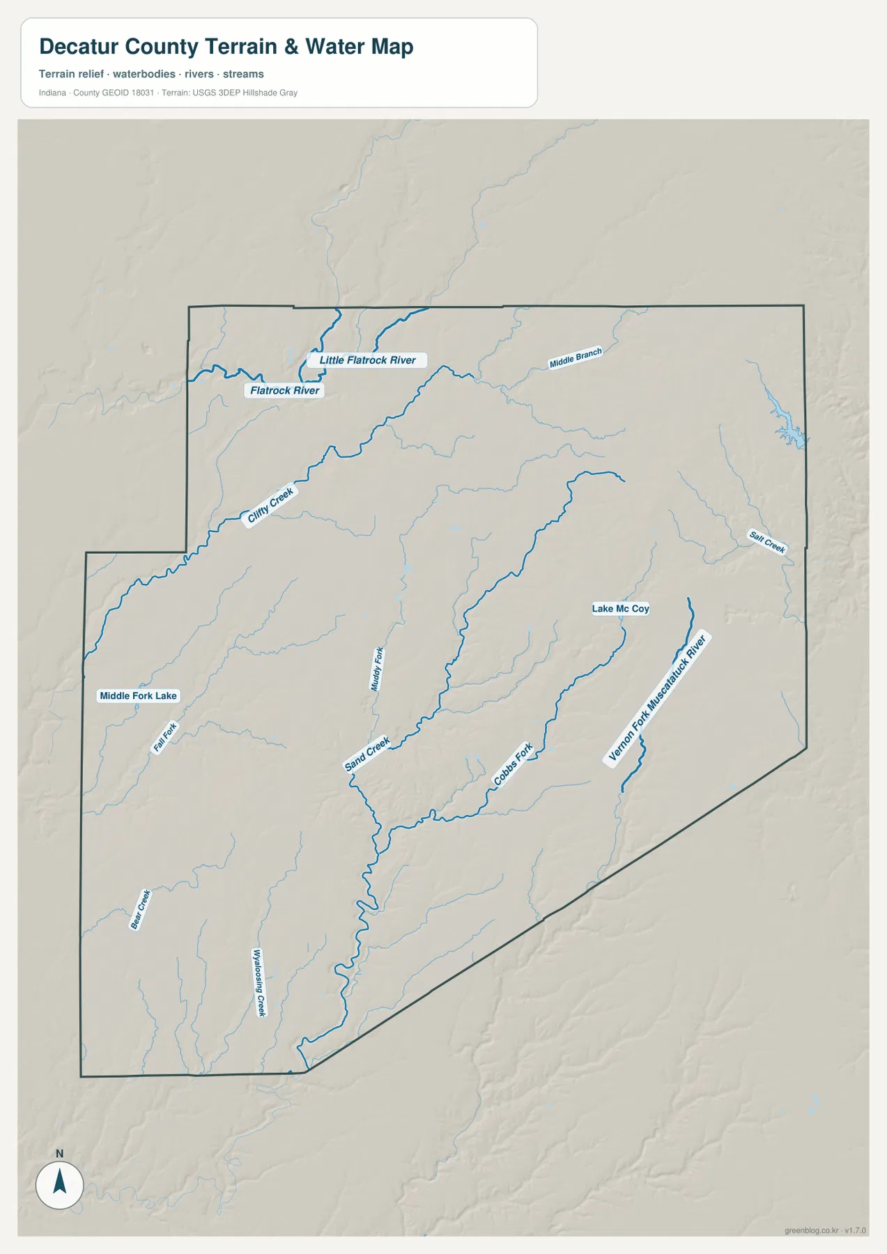
This is a water-reference map, not a flood determination, navigation chart, or parcel map. A wide-looking valley does not prove that a specific property is in a flood hazard area, and the blue lines do not provide water depth or boating conditions. Use the map to identify named rivers, creeks, lakes, and their broad relationship to the terrain. Flood insurance, construction, property boundaries, and water access require the appropriate current agency maps and site-specific information.
The elevation map rises from western greens to eastern browns
Decatur County’s elevation surface spans roughly 212 to 334 meters, with an average around 275 meters. The broadest low area occupies the west and southwest, where dark and medium greens dominate. Greensburg sits closer to the transition zone than to either extreme. Moving east from the city, the colors turn through light green and yellow into orange and brown, and the northeastern and eastern margins contain the most extensive high ground on the map.
The transition is not a smooth ramp. Long green valleys extend into the higher interior and break the uplands into separate ridges. Those low fingers line up with the creek corridors visible on the water map, especially through the central and southern parts of the county. The result is a landscape where two locations at a similar east-west position can sit at noticeably different heights if one is on a ridge and the other is in a stream valley.
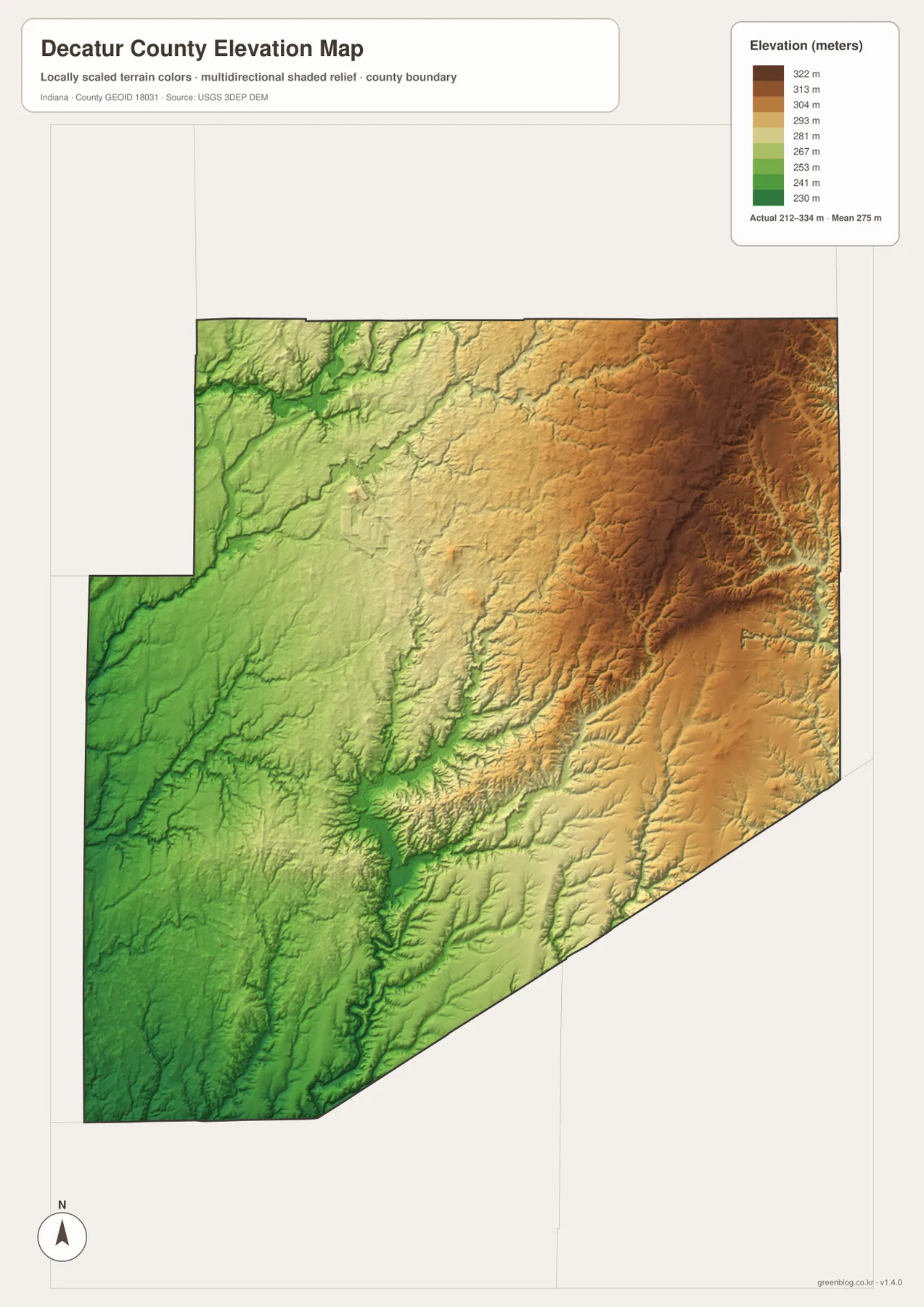
Comparing the road and elevation maps adds useful context without turning the article into an engineering analysis. Long route segments are more common across some of the gentler western ground, while the eastern side contains more closely spaced valleys and ridges. That does not mean every bend in a road is caused by elevation, but the terrain helps explain why the county does not have one uniform grid. For cycling, construction, or detailed slope work, a county-scale color surface is not precise enough; use a detailed elevation product or field measurement.
The elevation colors are generalized for regional comparison. Small cuts, fills, drainage ditches, and local slopes may not appear at this scale, and the exact ground height can vary within a single color band. The map is useful for recognizing the lower western half, the central stream valleys, and the higher eastern hills. It should not replace survey-grade measurements or engineering plans.
Choose the map by the question, not by the number of layers
Greensburg and I-74 provide the quickest orientation on the general map, while St. Paul, Westport, Millhousen, and New Point show how far the county spreads in different directions. When the road labels begin to compete for attention, the city-connections map gives those communities a simpler shape around Greensburg. With that arrangement in mind, returning to the general map makes the highway and state-road pattern easier to follow without turning the section into a list of places to memorize.
For landscape questions, start in the northwest with Flatrock River on the water map and compare that area with the green lowlands on the elevation map. Then move to Cobb Fork and Vernon Fork Muscatatuck River in the southeast and notice how much more strongly the valleys cut into higher terrain. The two maps describe the same county from different angles: one emphasizes named water features, while the other makes the ridge-and-valley contrast immediately visible.
The WebP images in the article are reduced for efficient page loading. The ZIP below contains the original high-resolution JPG versions for closer inspection, printing, or offline reference. Each image measures 2572 × 3638 pixels, and the archive includes the general county map, city-connections map, terrain-and-water map, and elevation map. These are county reference maps rather than legal boundary, survey, flood-determination, or engineering products.
Local sources confirm the Greensburg-centered community pattern
Decatur County’s official website places the county courthouse on Courthouse Square in Greensburg, reinforcing the central role that the city also has on the map. Visit Greensburg’s cities-and-towns guide lists Greensburg together with Millhousen, New Point, Saint Paul, and Westport, the same outer communities emphasized by the city-connections graphic. The local pages are useful for government or visitor information; the maps here are designed to show where those places sit in relation to roads, waterways, and terrain.
Visit Greensburg’s map and transportation page also highlights I-74, U.S. 421, State Road 3, and State Road 46 as key connections for the area. Those are the same routes that provide the clearest orientation on the general county map. Current construction, traffic, and travel times can change, so a navigation service remains the right tool for a trip. For geographic orientation, however, these routes give a concise way to connect the local source information with the mapped settlement pattern.
Frequently Asked Questions
Which map is easiest for comparing St. Paul, Westport, Millhousen, and New Point?
Use the city-connections map first. Greensburg is the hub, with St. Paul to the northwest, Westport to the southwest, Millhousen to the southeast, and New Point to the east. The printed mileage is straight-line distance from Greensburg, not driving distance. Use the general map afterward when you need to see which major routes approach each community.
Where is the strongest elevation contrast in Decatur County?
The clearest contrast is between the lower west and southwest and the higher east and northeast. The mapped range is about 212 to 334 meters. Stream valleys cut into the eastern uplands, so the county is not simply a steady slope; ridges and low channels alternate across the middle and eastern half.
What is included in the Decatur County map download?
The ZIP contains high-resolution JPG versions of the same four maps used in the article: the general county map, city-connections map, terrain-and-water map, and elevation map. Each file is 2572 × 3638 pixels. They are useful for enlargement and printing but are not substitutes for parcel, flood, survey, or engineering maps.
Map File Information
Download the Decatur County maps as high-resolution JPG files for closer viewing, printing, or offline reference.
- File Type: JPG
Related Maps
Sources and references
- Decatur County, Indiana official website — county government and Greensburg courthouse context
- Visit Greensburg — Decatur County cities and towns
- Visit Greensburg Maps — I-74, U.S. 421, State Road 3, and State Road 46 connections
- U.S. Census Bureau TIGER/Line Shapefiles — county boundaries, roads, and places
- USGS National Hydrography — rivers, streams, and drainage data
- USGS 3D Elevation Program — elevation and terrain data
Green Map creates custom-edited map images using open geographic data sources such as geoBoundaries, Natural Earth, OpenStreetMap, and government open data.
These maps are edited visual materials, not raw data files, and are provided for education, documents, presentations, and graphic reference.