Download the high-resolution A3 JPG Schuyler County Illinois Map ZIP directly from this page. Rushville is the clearest central reference, while Littleton lies to the north, Camden to the west, and Browning in the county’s long eastern extension. Across the western and central sections, La Moine River and numerous creeks cut deep branching valleys through higher hills. Near the far eastern end, Long Lake, Patterson Bay, and Mathew Bay appear in a much lower and flatter waterside landscape.
The WebP images on this page are sized for quick browser viewing, and the matching high-resolution A3 JPG map ZIP can be downloaded below. The original files are more convenient when small road or creek labels need to be enlarged or printed. A practical first pass is to locate Rushville, follow Route 24 across the county, then find Littleton on Route 101, Camden near Route 99, and Browning toward the east. After those communities are familiar, the water and elevation views show why the western hills and eastern lowlands look so different.
Table of Contents
Rushville connects a wide western block to a long eastern extension
The general county map makes Rushville the easiest place to start. It sits slightly south of the county’s middle, and several numbered roads pass through or near the community. Route 24 provides the main east-west reference, Route 101 runs north toward Littleton, and Route 103 appears along the southern side. Near the southeastern edge, routes 67 and 100 help orient the lowland section. Using Rushville as the center prevents the irregular boundary from becoming the first thing a reader has to decode.
Camden provides the strongest western reference. Route 99 runs north and south nearby, and Route 250 crosses the northwestern part of the county. Littleton is north of Rushville on the 101 corridor, while Browning occupies the narrow eastern section where the county shape becomes very different from the broad western block. These three places are not part of one continuous built-up area. Large stretches of rural land and stream valleys separate them, which is one of the county’s most visible characteristics.
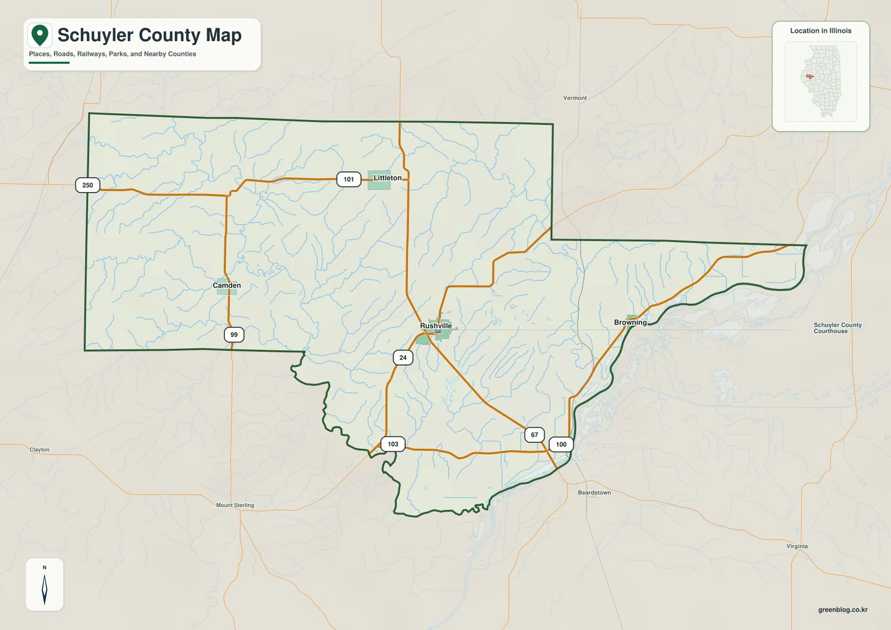
The southern boundary also changes character across the county. West of Rushville it is relatively broad, while south and southeast of Rushville the line becomes more irregular before stretching toward the low eastern section. Roads cross this terrain rather than simply following the boundary. The water and elevation maps help explain why, because many roads have to pass through or around branching valleys that are not obvious on the simpler road map.
Rushville has the densest local road pattern among the four highlighted communities, but Schuyler County does not read as a single urban region. Littleton, Camden, and Browning are widely separated by hilly rural terrain. Toward the eastern end, community labels become less dominant and water features occupy more of the visual space. This shift from a broad hilly interior to a narrow lowland extension is one of the best reasons to compare all of the supplied views rather than relying on the road map alone.
Three directions from Rushville at about eight to eleven miles
The city-connections map treats Rushville as the hub and simplifies the other three places into a clear directional pattern. The printed index lists Rushville first and marks it as HUB with a value of 2,747. Littleton is second with 105, Browning third with 99, and Camden fourth with 57. Those values are described here only as numbers printed on the supplied city map, not as newly verified current population counts.
The distance labels are straight-line distances from Rushville. Littleton is shown at about 8 miles, Browning at about 10 miles, and Camden at about 11 miles. The distances are fairly similar, but the directions are not: Littleton is north, Browning east, and Camden west. That three-way spread explains why Rushville works so well as the county’s orientation point. Actual road mileage can differ from these straight-line values, so the city map is best used for relative position rather than route planning.
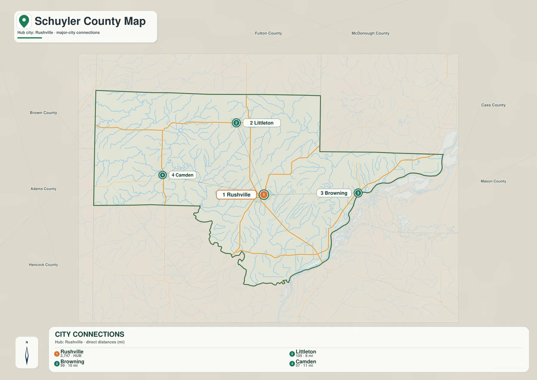
The simplified city map also highlights how different the surroundings of the three outer communities are. Camden lies in the western hill-and-creek landscape. Browning is close to the eastern lowland extension. Littleton sits north of Rushville where tributaries and higher ridges alternate across the map. The communities are similar in straight-line distance from the hub, yet each occupies a different part of the county’s terrain.
La Moine River cuts through the hills before water spreads eastward
La Moine River is the strongest water feature in the western and central county. It enters the northwestern side, bends through the west-central section, and continues southward while receiving numerous smaller tributaries. Cedar Creek and Missouri Creek are labeled in the west, and Flower Creek appears farther northwest. These streams occupy narrow valleys that become especially clear when the water map is compared with the elevation colors.
Farther north and east, West Branch Sugar Creek extends across the upper part of the county, while Sugar Creek runs through the eastern-central section. Around and south of Rushville, smaller named branches include Ryan Branch and Honey Branch, and Crane Creek appears farther south. The number of tributaries can make the map look crowded at first, but separating the La Moine River drainage from the Sugar Creek side provides a useful first division.
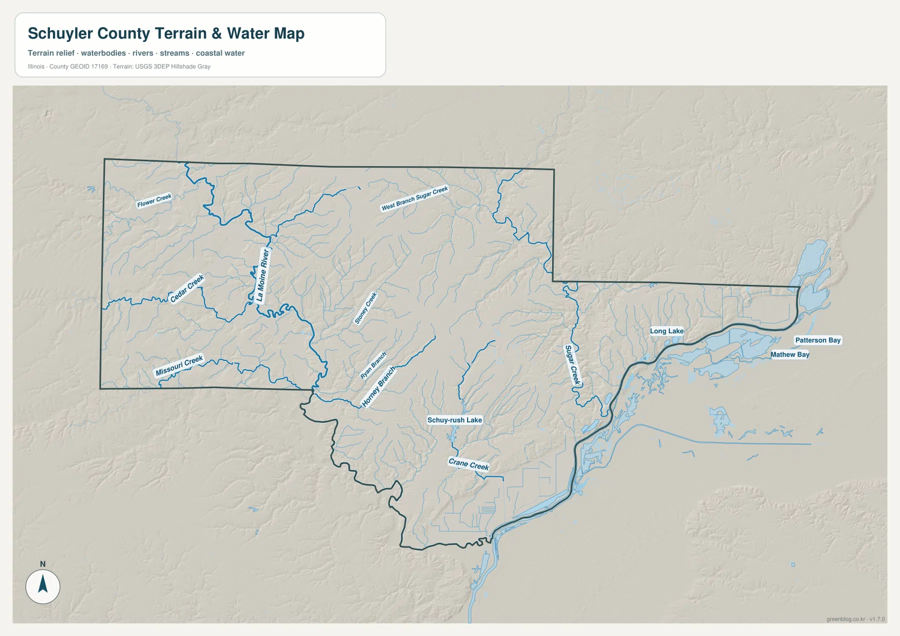
Schuy-Rush Lake is labeled south of Rushville and gives the central-southern area an easy local landmark. The county’s far eastern extension looks very different. Long Lake appears along the low corridor, and Patterson Bay and Mathew Bay sit farther east near the end of the county. Instead of narrow creek valleys cutting through hills, this area is characterized by broader low ground and elongated water features. That contrast is one of the most distinctive features in the supplied maps.
This water layer is intended for general geographic reference. A mapped river, creek, lake, or bay does not establish public access, navigability, current flood risk, water quality, or a legal shoreline boundary. For floodplain, property, navigation, or regulatory questions, a current specialized official source should be used instead.
129 to 227 meters reveals deep valleys between higher ridges
The supplied elevation map reports an actual range of about 129 to 227 meters and a mean near 178 meters. Low green terrain follows La Moine River and its major tributaries through the west-central and southern county. Broad low colors also dominate the far eastern and southeastern waterside section. In contrast, strong brown tones cover the north-central and central-eastern interior, and additional high ridges appear near the western edge.
The terrain is not a simple west-to-east slope. La Moine River and the smaller creeks cut narrow low corridors through high ground, splitting the hills into multiple ridges. North and east of Rushville, relatively high terrain remains continuous in several areas until tributary valleys cut across it. On the elevation map, these valleys appear as branching green channels; on the water map, the same lines are occupied by rivers and creeks.
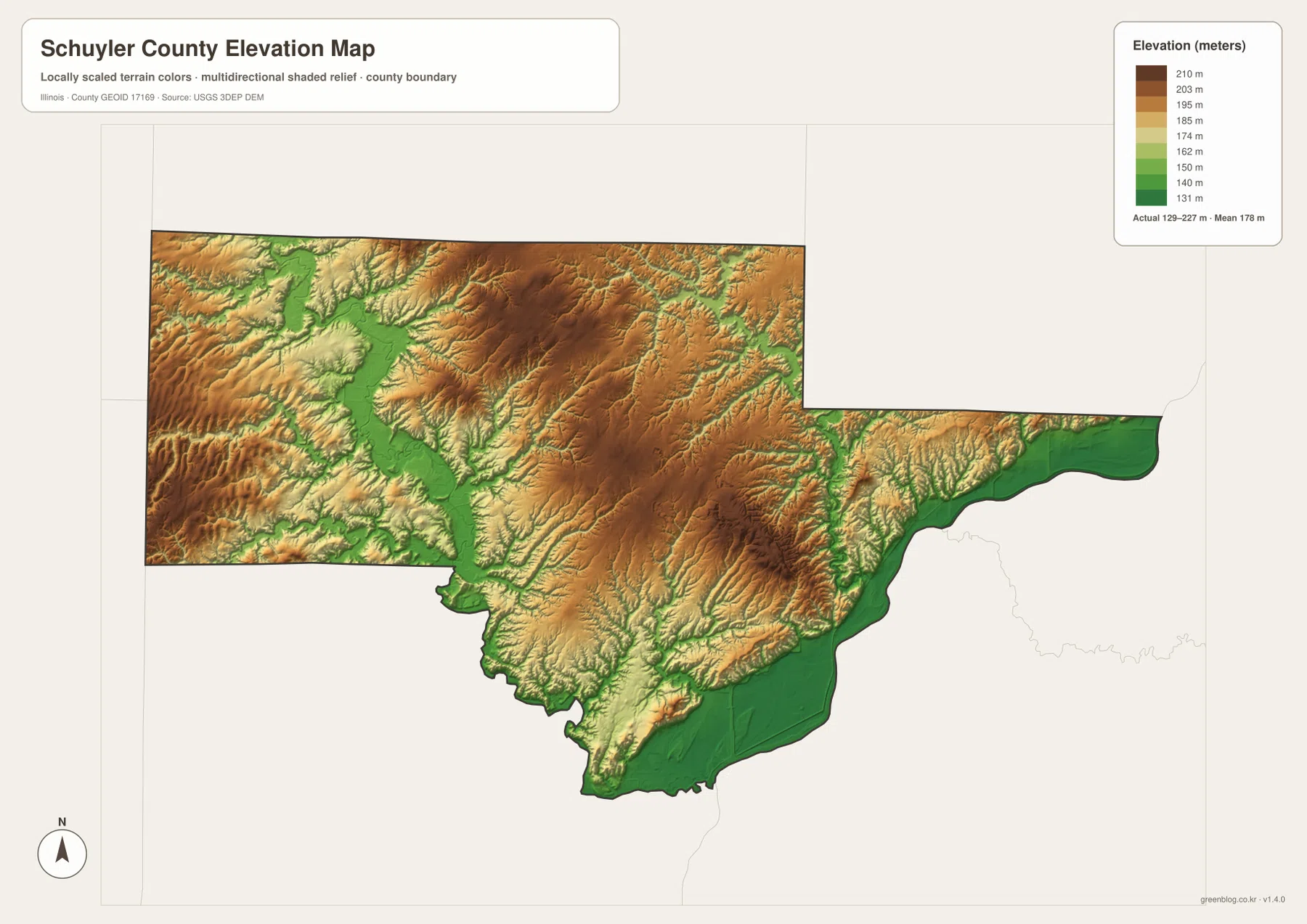
The long eastern extension provides the sharpest visual contrast with the western hills. East of Browning, higher ridges narrow and then give way to the low green ground around Long Lake and the bays. The southern boundary also contains extensive low terrain, although interior hills remain around the south-central part of the county. This mixture of high ridges and low water corridors makes Schuyler County look much more dissected than a simple road map suggests.
The elevation layer is suitable for county-scale comparison, not parcel surveying or engineering design. The 129–227 m range helps identify major valleys, low waterside areas, and high ridges, but it does not provide a survey-grade elevation for a specific address. The most useful reading is to compare the broad color zones and the way low corridors follow the river and creek network.
A practical order for reading Schuyler County
For roads and community locations, start with Rushville and Route 24, then find Littleton along Route 101 and Camden near Route 99 before moving east toward Browning. If the question is simply how the four highlighted communities relate to one another, the city-connections map gives the quickest answer with its 8–11 mile straight-line labels from Rushville. For water, begin with La Moine River and then add Cedar Creek, Sugar Creek, Schuy-Rush Lake, and the eastern Long Lake–Patterson Bay–Mathew Bay group.
The ZIP below contains the original high-resolution JPG files for the county-and-road map, city-connections map, terrain-and-water map, and elevation map. Each file is 3638 × 2572 pixels in landscape orientation, which makes small road and water labels easier to inspect or print than in the browser-sized WebP images. These maps are general reference products, so current road conditions, legal parcel boundaries, flood determinations, navigation rules, water-quality decisions, or survey-grade elevations should be checked with the appropriate current official source.
Frequently Asked Questions
How are Littleton, Browning, and Camden positioned from Rushville?
Littleton is north of Rushville, Browning is east, and Camden is west. The supplied city-connections map shows straight-line distances of about 8 miles to Littleton, 10 miles to Browning, and 11 miles to Camden. Actual road mileage can differ from these direct distances.
Which water features stand out besides La Moine River?
Cedar Creek and Missouri Creek are prominent in the west, West Branch Sugar Creek crosses the north, and Sugar Creek appears in the eastern-central section. Schuy-Rush Lake lies south of Rushville, while Long Lake, Patterson Bay, and Mathew Bay mark the low eastern extension.
Where are the lower and higher areas on the elevation map?
Lower green terrain follows La Moine River and its tributary valleys and spreads across the far eastern and southeastern waterside section. Higher brown ridges cover much of the north-central and central-eastern interior. The supplied elevation map reports an actual range of about 129 to 227 meters and a mean near 178 meters.
Map File Information
The ZIP contains high-resolution A3 JPG versions of the Schuyler County road-and-boundary map, city-connections map, terrain-and-water map, and elevation map.
- Printable Size: 3638 × 2572 pixels each
- File Type: ZIP containing 4 JPG files
Related Maps
Sources and references
- U.S. Census Bureau TIGER/Line Shapefiles – county boundaries, roads, and place references
- USGS National Hydrography – rivers, streams, lakes, and other water features
- USGS 3D Elevation Program – elevation and terrain reference
Green Map creates custom-edited map images using open geographic data sources such as geoBoundaries, Natural Earth, OpenStreetMap, and government open data.
These maps are edited visual materials, not raw data files, and are provided for education, documents, presentations, and graphic reference.