Download four high-resolution JPG maps of Mercer County, Illinois, in one ZIP from this page, then use the article views to compare Aledo, New Boston, Viola, Sherrard, the Mississippi River edge, inland streams, and elevation. Aledo sits near the center of the county and provides the easiest road reference. New Boston and Keithsburg occupy the western river side, while Viola, Windsor, Matherville, and Sherrard are spread across the eastern half.
The physical landscape changes sharply between those areas. Broad low terrain follows the Mississippi River on the west, but the land rises into rolling and deeply cut uplands across the north and east. Edwards River crosses the middle of the county, with Camp Creek farther north and Pope Creek and North Henderson Creek across the south. The elevation map reports an actual range of about 159 to 250 meters and a mean near 207 meters, making the difference between river lowlands and inland hills easy to see.
Table of Contents
Route 17 ties New Boston to Aledo, Viola, and the eastern county
The county map is easiest to read from Aledo. Route 17 comes east from New Boston through Joy, reaches Aledo, and continues toward Viola and Windsor. Route 94 crosses that line at Aledo and runs north-south through the middle of the county. Together, those two roads establish a simple central reference before the map branches toward the river communities, northeastern villages, and southern settlements.
Viola sits in the eastern half where another north-south route crosses the Route 17 corridor. Matherville is farther north, and Sherrard is close to the northeastern corner. Route 67 continues south from the Viola side toward the Alexis area along the lower boundary. In the west, New Boston hugs the Mississippi River while Joy occupies the inland space between the river and Aledo. Keithsburg and Seaton sit much farther south and are separated from the main Route 17 line.
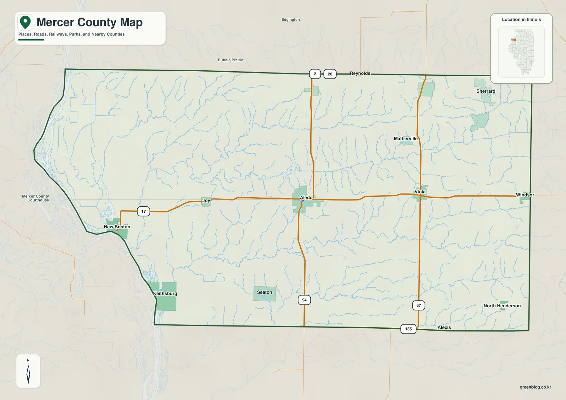
The county outline reinforces the difference between west and east. Its western boundary curves with the Mississippi River around New Boston and Keithsburg, while the southern and eastern edges are much straighter. The map is intended for geographic orientation rather than live navigation, so current driving times, road closures, and traffic conditions should still be checked with a dedicated road service.
Aledo stands apart from a cluster of smaller eastern communities
The ranked city map highlights six communities. Its index lists Aledo at 3,668, Viola at 899, Windsor at 704, Sherrard at 691, Matherville at 657, and New Boston at 648. Aledo is clearly the largest highlighted place and sits near the center. Four of the smaller communities are distributed across the east and northeast, while New Boston occupies a completely different river-side setting on the west.
Viola is central-east, Windsor is near the eastern edge, and Matherville and Sherrard occupy the northeast. Those four places do not form one dense urban block, but they are all east of Aledo and relatively far from the Mississippi River. New Boston is the opposite case, standing alone beside the western river boundary. The city map makes this east-west contrast much easier to see because most road labels and minor settlements are removed.
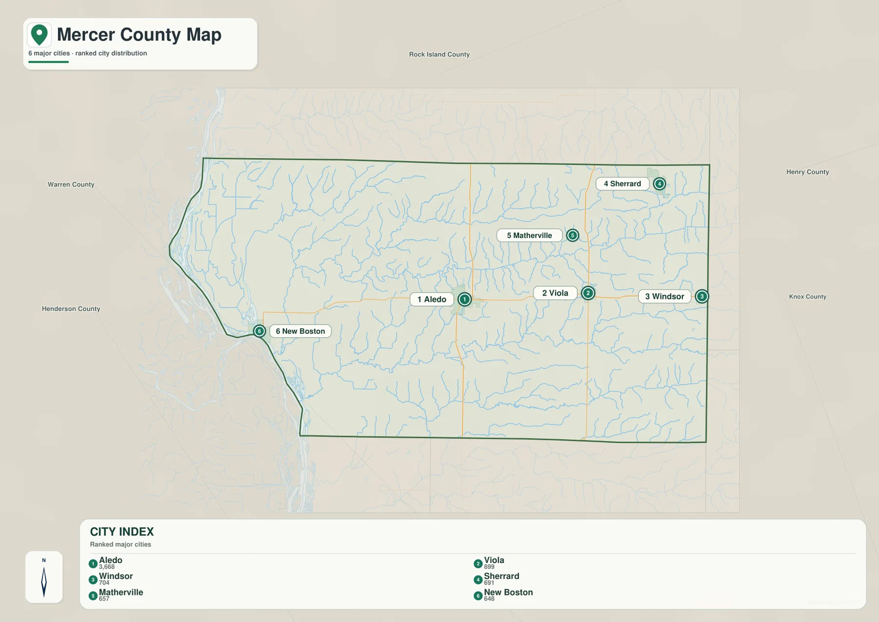
The general county map adds Joy, Keithsburg, Seaton, and other labels that explain the spaces between the six ranked places. Joy sits between New Boston and Aledo, Keithsburg provides a second southwestern river reference, and Seaton fills part of the southern interior. Switching between the two settlement maps keeps population rank separate from road geography while still showing how the communities fit together.
Edwards River crosses the interior between Mississippi River wetlands and eastern creeks
The terrain and water map is organized around two very different settings. Along the west, the Mississippi River corridor contains broad water and lowland features such as Swan Lake and Boston Bay. Inland, Edwards River crosses the central part of the county in a long valley before reaching the river side. Mad River appears farther south, while Eliza Creek descends through the northwestern hills.
Across the northern interior, Camp Creek runs east-west with Lake Nelson nearby. Lake Matherville sits farther east, and Karl Lake and Fyre Lake mark the northeastern corner. The southern half has a separate set of streams: Pope Creek crosses the interior, North Pope Creek and Maids Run occupy the southeast, and North Henderson Creek follows a long lower corridor near the southern edge. These waterways cut numerous narrow valleys into otherwise higher rolling ground.
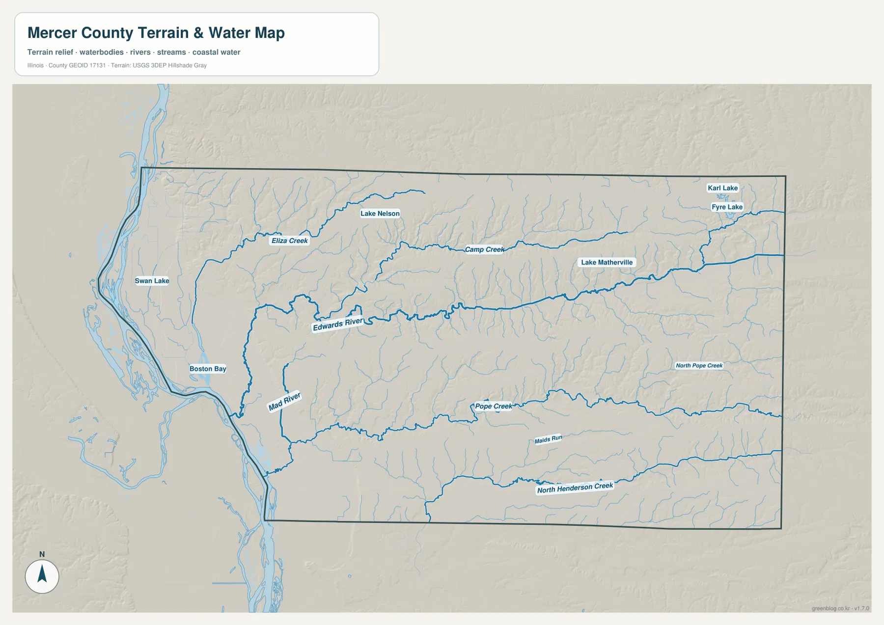
The purpose of this map is to show the relative location of rivers, creeks, lakes, and terrain. It is not a flood-risk map, legal water-boundary product, navigation chart, or drainage-engineering document. When placed beside the elevation map, Edwards River, Camp Creek, Pope Creek, and North Henderson Creek line up with lower corridors that break up the inland uplands.
From 159 m Mississippi River flats to 250 m northern and eastern uplands
The elevation map reports an actual range of about 159 to 250 meters and a mean near 207 meters. The darkest greens cover the broad western edge beside the Mississippi River, including the New Boston and Keithsburg side of the county. That low terrain is wide and relatively smooth compared with the strongly textured hills that begin just inland.
The highest brown terrain spreads across much of the north and east. Numerous tributaries have cut narrow valleys into those uplands, creating a branching pattern of green and yellow corridors. Edwards River forms the most obvious central low band, while Camp Creek creates another long cut in the north. Pope Creek and North Henderson Creek break the southern and southeastern uplands into smaller ridges.
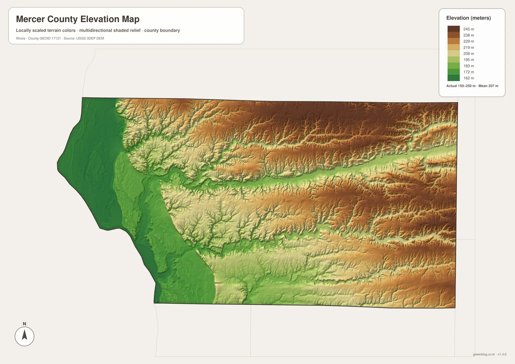
The elevation surface is generalized for county-scale comparison and should not be treated as survey-grade height, parcel elevation, or engineering data. For ordinary map reading, however, it makes the water map much easier to understand. The major streams occupy lower green corridors, while the broad tan and brown areas between them represent the higher rolling interior.
Compare Aledo, New Boston, and the eastern uplands across the maps
Use the county map when roads, the full boundary, and the complete settlement pattern matter most. The ranked city map is better for comparing Aledo, Viola, Windsor, Sherrard, Matherville, and New Boston without extra road detail. The terrain and water map is the clearest source for Edwards River, Boston Bay, Camp Creek, Lake Matherville, and the southern creeks, while the elevation map explains the dramatic difference between the western river lowlands and higher inland ground.
Aledo is a useful place to follow through all four views. The county map shows Routes 17 and 94 crossing near the city, and the ranked city map places Aledo between the eastern group and New Boston. The water map adds the nearby Edwards River corridor, while the elevation map shows that the interior around Aledo is much more rolling than the Mississippi River floodplain. New Boston provides the opposite example because the road, water, and elevation views all place it close to the broad western lowland.
Frequently Asked Questions
Why is western Mercer County so low on the elevation map?
The western boundary follows the Mississippi River, and broad low river terrain surrounds the New Boston and Keithsburg side of the county. It appears dark green on the elevation map. Moving inland toward Aledo and farther east, the land rises into tan and brown uplands. Edwards River cuts a lower central valley through that higher interior.
Which map is best for comparing Aledo, Viola, and New Boston?
The ranked city map is the quickest comparison. Aledo is central, Viola is east, and New Boston is on the western Mississippi River edge. Sherrard and Matherville are northeast, while Windsor is near the eastern boundary. Switch to the county map when you also want Route 17, Route 94, Route 67, and the smaller communities between them.
What files are included in the downloadable ZIP?
The ZIP contains four high-resolution JPG files: the county and road map, ranked city map, terrain and water map, and elevation map. Each image is 3638 × 2572 pixels. Smaller WebP versions are used in the article for faster viewing, while the JPG files are better for close inspection and print. The water and elevation maps are general geographic references rather than flood, legal-boundary, survey, or engineering products.
Map File Information
Download the Mercer County county map, ranked city map, terrain and water map, and elevation map together as high-resolution JPG files.
- Included Files: Use only the versions confirmed in the article and supplied images
- File Type: Use the confirmed download contents
- Intended Use: Printing, education, presentations, and map-based projects
Related Maps
Sources and references
- U.S. Census Bureau TIGER/Line Shapefiles – county boundaries, roads, and place reference
- USGS National Hydrography – rivers, creeks, lakes, and other hydrography reference
- USGS 3D Elevation Program – elevation and terrain reference
- City of Aledo – About Aledo – official local information for Aledo and its Mercer County setting
- Visit Mercer County – Our Communities – community information for New Boston, Keithsburg, Sherrard, Viola, and other Mercer County places
Green Map creates custom-edited map images using open geographic data sources such as geoBoundaries, Natural Earth, OpenStreetMap, and government open data.
These maps are edited visual materials, not raw data files, and are provided for education, documents, presentations, and graphic reference.