Download four high-resolution JPG maps of Menard County, Illinois, in one ZIP from this page, then use the article views to compare Petersburg, Athens, Greenview, Tallula, Oakford, the Sangamon River, and the county’s relief. Petersburg sits in the central-western part of the county and is the easiest reference point. Athens lies southeast, Greenview northeast, Oakford northwest, and Tallula southwest, giving Menard County a settlement pattern that spreads in several directions rather than forming one continuous town corridor.
The terrain is organized just as strongly around the Sangamon River. A deep, low corridor bends through the center of the county near Petersburg and Lake Petersburg, while higher rolling ground rises on both sides. The elevation map reports an actual range of about 139 to 202 meters and a mean near 175 meters. Smaller waterways such as Indian Creek, Grove Creek, Pike Creek, and Rock Creek cut additional valleys into the uplands, so the county is much more textured than a flat road map alone might suggest.
Table of Contents
Petersburg links the Route 97 south with Athens, Greenview, and Tallula
The county map is easiest to read by starting at Petersburg. Route 97 runs south from the city, while Route 123 approaches from the Tallula side and connects with the Petersburg area. Route 29 serves the Athens and Greenview side of the county, creating a separate north-south line east of the Sangamon River valley. With those roads in mind, the county’s five principal settlements become much easier to locate.
Oakford sits alone in the northwest, reached by a diagonal road that descends through the western hills toward Petersburg. Tallula is near the southwestern boundary and lies on the Route 123 corridor. Athens occupies the southeastern extension of the county, while Greenview is north of the central river valley. The result is a road pattern shaped by both the county outline and the rolling terrain rather than a simple rectangular grid.
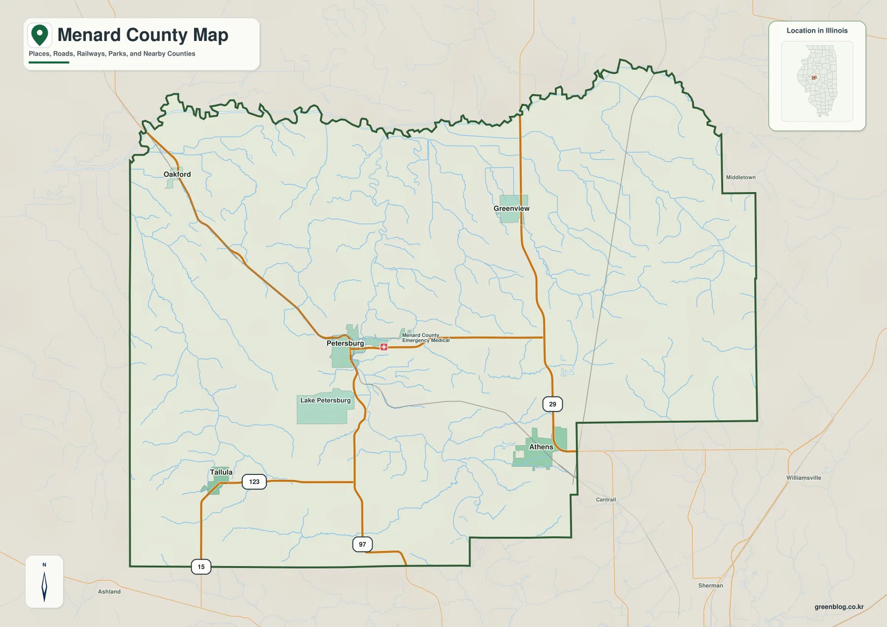
The boundary itself adds useful context. The northeastern side rises into a broad rounded extension before stepping inward on the east, while the Athens area forms a lower southeastern projection. The west side is straighter and more open. This map is designed for geographic orientation rather than live navigation, so actual driving times, current road conditions, and turn-by-turn directions should still be checked with a dedicated road service.
Four towns sit six to eight straight-line miles from Petersburg
The city-connections map uses Petersburg as the hub. Its index lists Petersburg at 2,341, Athens at 2,102, Greenview at 912, Tallula at 494, and Oakford at 191. Athens, Greenview, and Oakford are each shown about 8 miles from Petersburg, while Tallula is about 6 miles away. These figures are straight-line distances between mapped points, not road mileage.
Similar distance does not mean similar location. Athens is southeast of the hub, Greenview northeast, Oakford northwest, and Tallula southwest. Petersburg therefore sits near the middle of a four-direction arrangement. The surrounding terrain also differs: Athens is closer to the eastern creek valleys, while Oakford and Tallula sit toward higher western ground. The city map is useful for direction and spacing, but the road and elevation maps are needed to understand what lies between the towns.
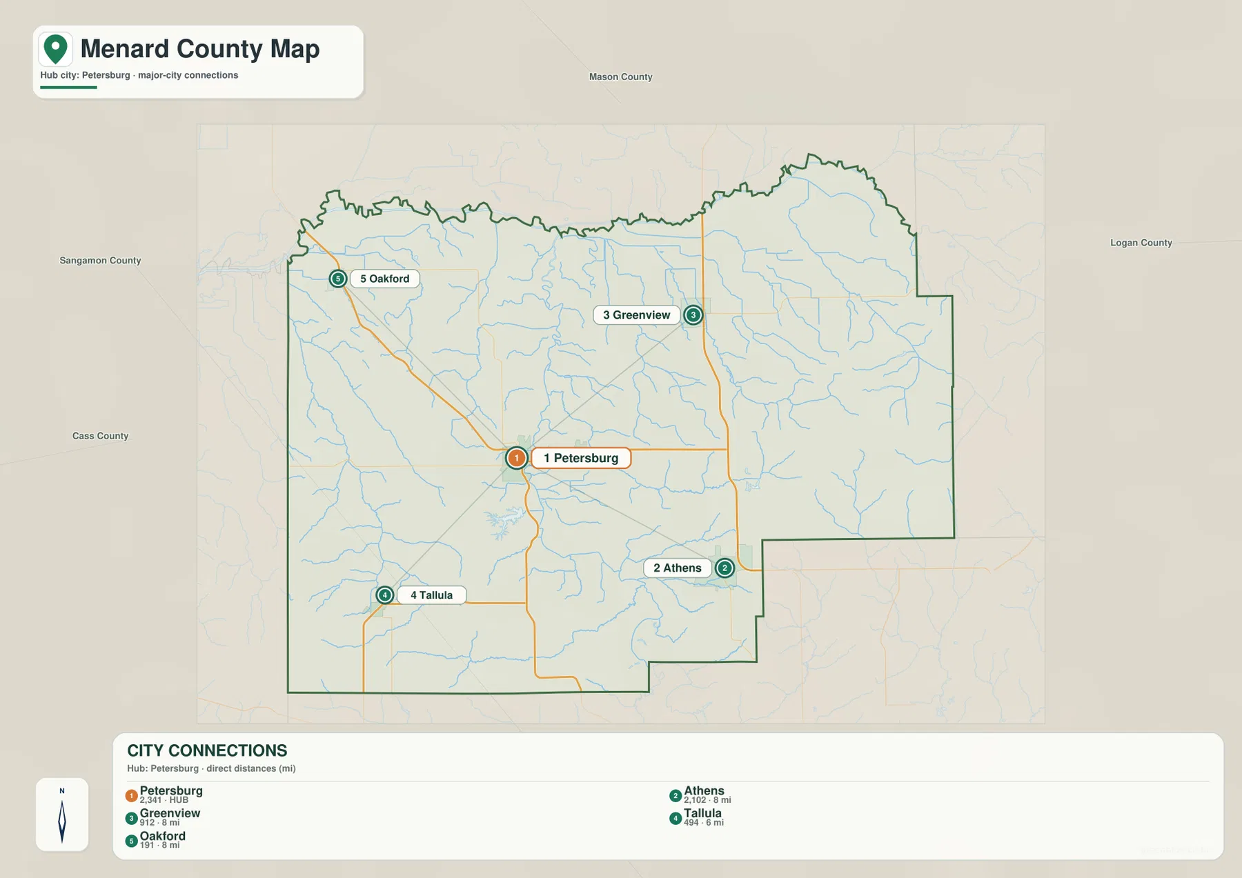
Once the directions are clear, the county map adds the travel context. Athens and Greenview align with the Route 29 side, Tallula with Route 123, and Oakford with the northwest hill road. This is why the connection map should not be treated as a driving-distance graphic. Two places can have nearly the same straight-line distance from Petersburg but very different road approaches.
Sangamon River bends through the center beside Lake Petersburg
The terrain and water map is dominated by the Sangamon River. The river enters the county from the northwest, bends into the central corridor near Petersburg, and continues south through a broad low valley. Lake Petersburg lies just west of this river corridor south of the city. The river and lake are the easiest water features to connect with the elevation map because they occupy some of the county’s lowest ground.
Smaller streams descend toward the main valley from both sides. Little Grove Creek and Clary Creek cross the western uplands, while Indian Creek, Rock Creek, Halls Branch, and Town Branch occupy the central and southern areas. Grove Creek and Pike Creek drain the eastern side. Together they create a branching network of narrow valleys that cuts deeply into the higher rolling terrain.
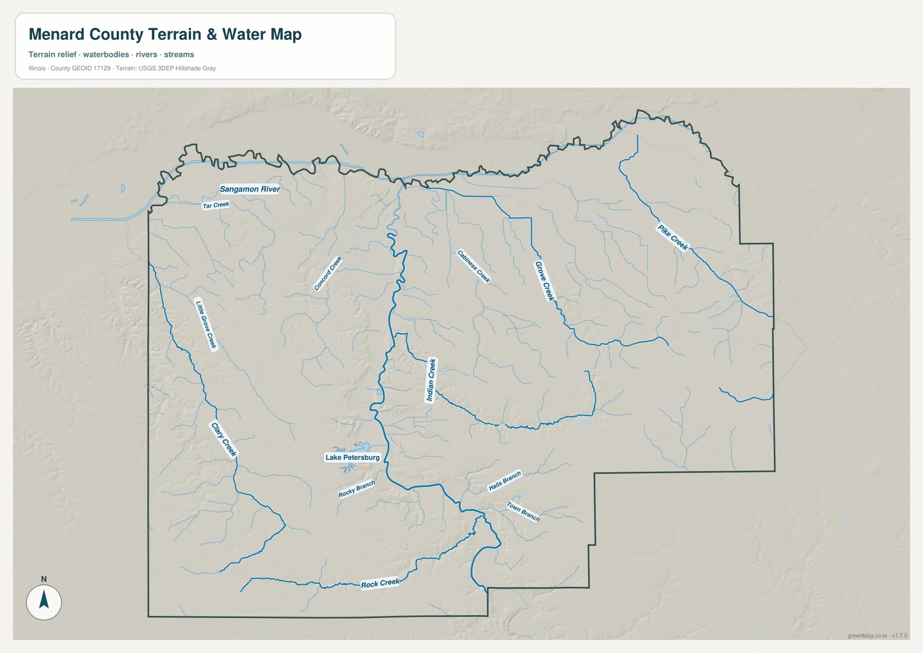
Illinois DNR also places Lincoln’s New Salem State Historic Site just south of Petersburg near the Sangamon River. The historic site is not separately labeled on the supplied county maps, but the official location reinforces the importance of the Petersburg-river corridor as a local geographic reference. The water map itself remains a general geographic product rather than a flood-risk map, legal water-boundary document, navigation chart, or drainage-engineering map.
A 139–202 m landscape cut by one deep central river valley
The elevation map reports an actual range of about 139 to 202 meters and a mean near 175 meters. Its most striking feature is the long dark-green Sangamon River corridor through the center. The valley is particularly narrow and clear near Petersburg, then widens and bends southward. Low green terrain also follows several tributaries, creating branching cuts into the surrounding hills.
Higher ground rises quickly away from the river. Broad tan and brown hills cover the west and southwest, including the Oakford-Tallula side of the county. The eastern half also contains substantial uplands between Grove Creek, Pike Creek, and smaller tributaries. East-central and southeastern Menard County show some of the broadest high areas, while the river corridor remains a continuous low divide through the middle.
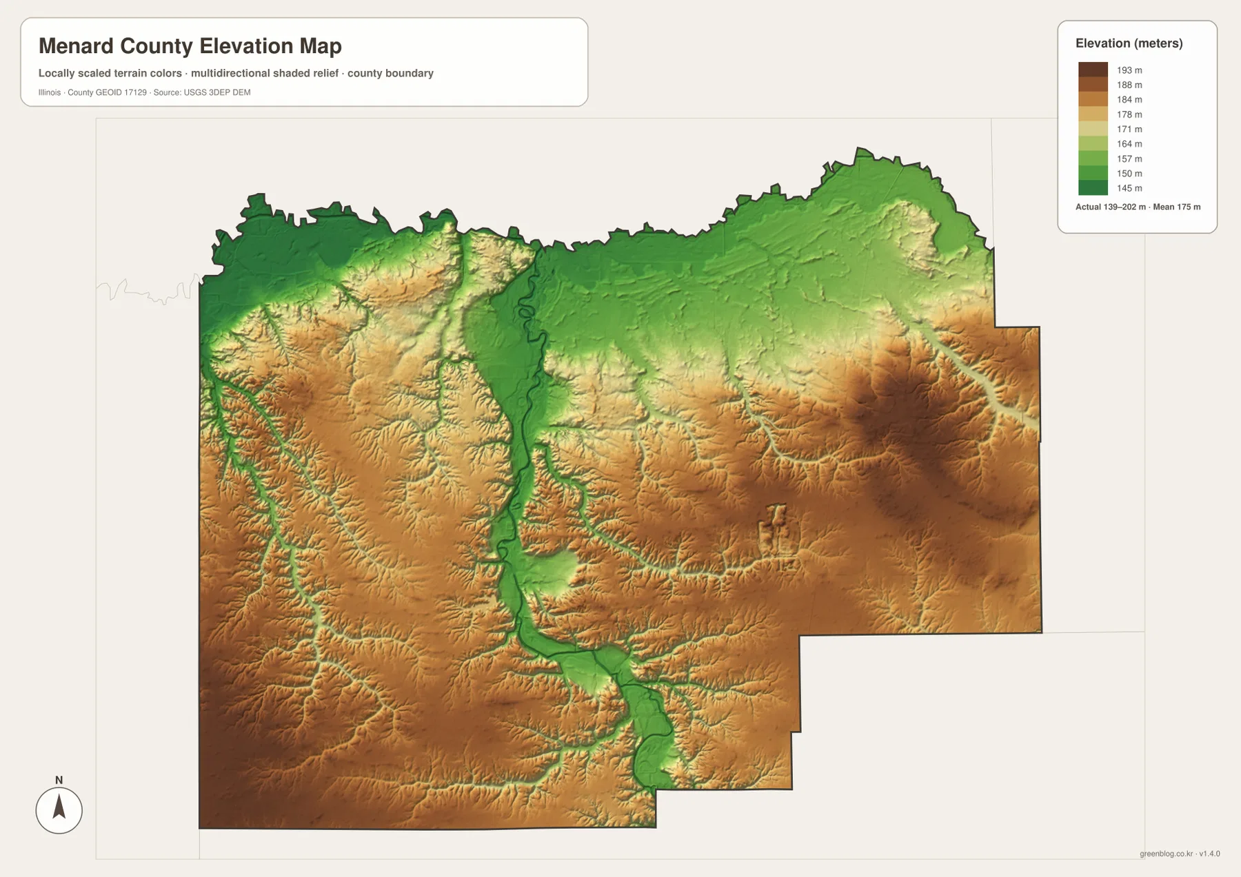
The elevation surface is generalized for county-scale comparison and should not be treated as survey-grade height, parcel elevation, or engineering data. For ordinary map reading, however, it makes the water network much easier to understand. Sangamon River, Indian Creek, Grove Creek, and other named streams line up with the lower green corridors, while the higher hills occupy the spaces between them.
Use Petersburg to connect roads, water, and relief across the maps
Start with the county map when roads, boundary shape, and all five labeled settlements matter most. The city-connections map is better when the question is how Athens, Greenview, Tallula, and Oakford are positioned around Petersburg and how far away they are in straight-line distance. The terrain and water map is the clearest source for Sangamon River, Lake Petersburg, and the named creeks, while the elevation map explains the deep river valley and the higher hills on both sides.
Petersburg works well as a reference across all four views. The road map shows its central-west location and Route 97 connection, the city map makes it the hub of the four-direction settlement pattern, the water map places it next to the Sangamon River and Lake Petersburg, and the elevation view shows the city beside the county’s lowest central corridor. Repeating the same exercise with Athens or Tallula reveals how quickly the roads and terrain change away from the river.
Frequently Asked Questions
How far are Athens, Greenview, Tallula, and Oakford from Petersburg on the city map?
The city map shows Athens, Greenview, and Oakford about 8 miles from Petersburg and Tallula about 6 miles away. These are straight-line distances between the mapped locations, not driving distances. The directions are also different: Athens is southeast, Greenview northeast, Oakford northwest, and Tallula southwest of the hub.
Why does the center of Menard County look so low on the elevation map?
The Sangamon River bends through the middle of the county and has carved a long low valley. That corridor appears dark green on the elevation map, while the western, southwestern, and eastern hills rise into tan and brown terrain. The water and elevation maps line up closely because many tributaries also follow narrow low valleys toward the main river.
What files are included in the downloadable ZIP?
The ZIP contains four high-resolution JPG files: the county and road map, city-connections map, terrain and water map, and elevation map. Each image is 3638 × 2572 pixels. Smaller WebP versions are used in the article for faster viewing, while the JPG files are better for close inspection and print. The water and elevation maps are general geographic references rather than flood, legal-boundary, survey, or engineering products.
Map File Information
Download the Menard County county map, city-connections map, terrain and water map, and elevation map together as high-resolution JPG files.
- Included Files: Use only the versions confirmed in the article and supplied images
- File Type: Use the confirmed download contents
- Intended Use: Printing, education, presentations, and map-based projects
Related Maps
Sources and references
- U.S. Census Bureau TIGER/Line Shapefiles – county boundaries, roads, and place reference
- USGS National Hydrography – Sangamon River, streams, lakes, and other hydrography reference
- USGS 3D Elevation Program – elevation and terrain reference
- Illinois DNR – Lincoln’s New Salem – official information for the historic site south of Petersburg near the Sangamon River
Green Map creates custom-edited map images using open geographic data sources such as geoBoundaries, Natural Earth, OpenStreetMap, and government open data.
These maps are edited visual materials, not raw data files, and are provided for education, documents, presentations, and graphic reference.