This Lawrence County, Illinois map page lets you download a ZIP containing four high-resolution JPG maps while also explaining the county in plain geographic terms. Lawrenceville provides the clearest central reference for roads and settlements, the Embarras River crosses the interior, and the Wabash River forms the irregular eastern border with Indiana. The map set also shows the hillier ground around Red Hills in the west and the broader lowlands toward the eastern river boundary.
The county becomes easier to understand when roads, towns, waterways, and elevation are viewed together rather than as separate lists. Lawrenceville sits in the east-central part of the county where major routes converge. Bridgeport and Sumner extend westward, St. Francisville lies toward the southeast, and Russellville is near the northeastern edge. The interior streams generally work toward the Embarras system, while the elevation map shows a clear contrast between rugged western hills and lower central and eastern land.
Four supplied maps cover different kinds of questions. The county map combines the boundary, towns, and major roads; the settlement-connections map simplifies the view to Lawrenceville and four nearby communities; the terrain-and-water map emphasizes the Embarras River, named creeks, lakes, ponds, and ditches; and the elevation map shows an actual county range of about 119 to 192 meters. The sections below explain what is visible on each map and when each version is most useful.
Table of Contents
Lawrenceville, Route 50, and the roads crossing the east-central county
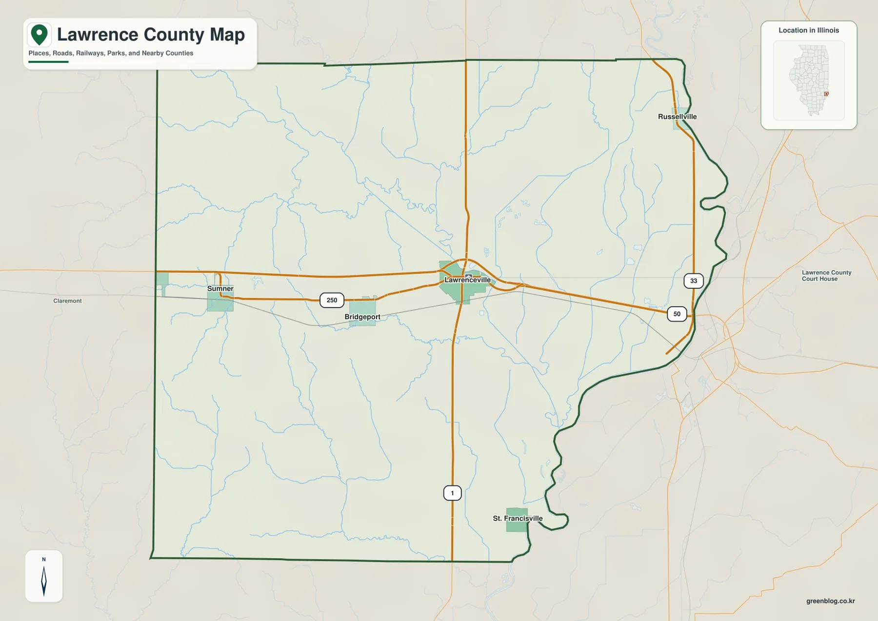
Lawrenceville is the best place to begin reading the county map. It sits in the east-central part of Lawrence County where the east-west road corridor meets the north-south Route 1 corridor. Route 50 continues toward the Wabash River side of the county, while Route 250 heads west through Bridgeport toward Sumner. Once Lawrenceville is fixed as the reference point, the rest of the county is much easier to orient because the principal communities spread away from it in several directions rather than clustering along one continuous urban strip.
Bridgeport lies just west of Lawrenceville and works as a transition point toward the western half of the county. Sumner is farther west on the same general corridor and is close to the Red Hills area, where terrain becomes noticeably more broken. The county map itself is not an elevation display, but the road-and-place pattern helps connect the later terrain map to recognizable locations. A reader can move from Lawrenceville to Bridgeport and Sumner on the overview, then compare that route with the higher ridges and ravines visible on the elevation map.
Route 1 provides the clearest north-south reference. It passes through Lawrenceville and continues toward the southern part of the county, with St. Francisville positioned southeast of the central road junctions. St. Francisville is also close to the eastern river boundary, so it is useful when locating the narrow southern portion of Lawrence County. The combination of a relatively straight western and southern boundary with a highly irregular eastern edge gives the county a shape that is easier to recognize once the Wabash River is understood as part of the boundary.
The eastern edge is not simply an administrative line drawn through flat space. An official Illinois county profile identifies the Wabash River as Lawrence County’s eastern boundary. That explains the long bends and indentations visible on the map, which contrast strongly with the straighter western boundary. The river name is not the most prominent label on the county overview, but the shape of the border itself is an important piece of geographic information because it marks both the county line and the Illinois–Indiana state line.
Russellville appears near the northeastern edge rather than in the main Lawrenceville–Bridgeport corridor. Roads and settlement labels are less concentrated around it than around Lawrenceville, while the east-central area contains a denser web of connections. This overview is therefore most useful for county-scale orientation, not for turn-by-turn navigation. Current road conditions, travel times, and local access restrictions should always be checked in a live road service, but the map gives a clean picture of how the main communities relate to the county boundary and major routes.
How Sumner, Bridgeport, St. Francisville, and Russellville sit around Lawrenceville
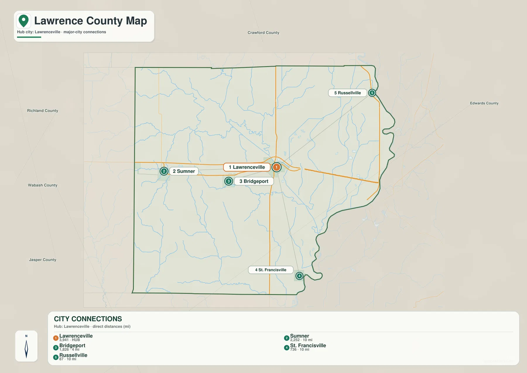
The settlement-connections map removes many minor details and makes Lawrenceville the hub. Bridgeport is immediately to the west, Sumner is farther west, St. Francisville is southeast, and Russellville is northeast. This arrangement makes it clear that Lawrence County does not have a single chain of towns running in one direction. Instead, Lawrenceville works as a practical central reference while the other labeled places mark different edges and sections of the county.
The map’s city index includes reference figures of 3,941 for Lawrenceville, 2,252 for Sumner, 1,826 for Bridgeport, 786 for St. Francisville, and 87 for Russellville. These are values printed on the supplied map and should not be treated as a substitute for the latest Census population estimates. Their main value here is comparative: Lawrenceville is presented as the hub, Sumner and Bridgeport are the larger western references, and the smaller St. Francisville and Russellville labels help anchor the southeastern and northeastern edges.
The distance labels are direct, straight-line distances rather than road mileage. Bridgeport is shown about 4 miles from Lawrenceville, while Sumner, St. Francisville, and Russellville are each shown at about 10 miles. Driving distance can be longer because roads do not follow a straight line and the river boundary limits some eastward connections. For county orientation, however, the straight-line values make the map immediately useful: Bridgeport is the nearby western neighbor, while the other three settlements form a wider ring around Lawrenceville.
Sumner is especially helpful for connecting the settlement map with the physical landscape. The Illinois Department of Natural Resources places Red Hills State Park in Lawrence County near Sumner and describes the park as a landscape of high wooded hills and deep ravines. That description matches the rougher western terrain visible on the elevation map. The settlement map does not show park boundaries, but locating Sumner first gives a reliable reference for finding the high-relief Red Hills area on the other maps.
St. Francisville and Russellville help show the length of the county’s Wabash-facing side. St. Francisville sits near the southeastern portion of the river boundary, while Russellville marks the northeast. Bridgeport and Sumner, by contrast, pull the eye west into the interior. This is why the simplified settlement map works well before reading the more detailed county map: it establishes a small set of geographic anchors without asking the reader to process every road, creek, and minor feature at once.
Embarras River tributaries, interior lakes, and the Wabash River edge
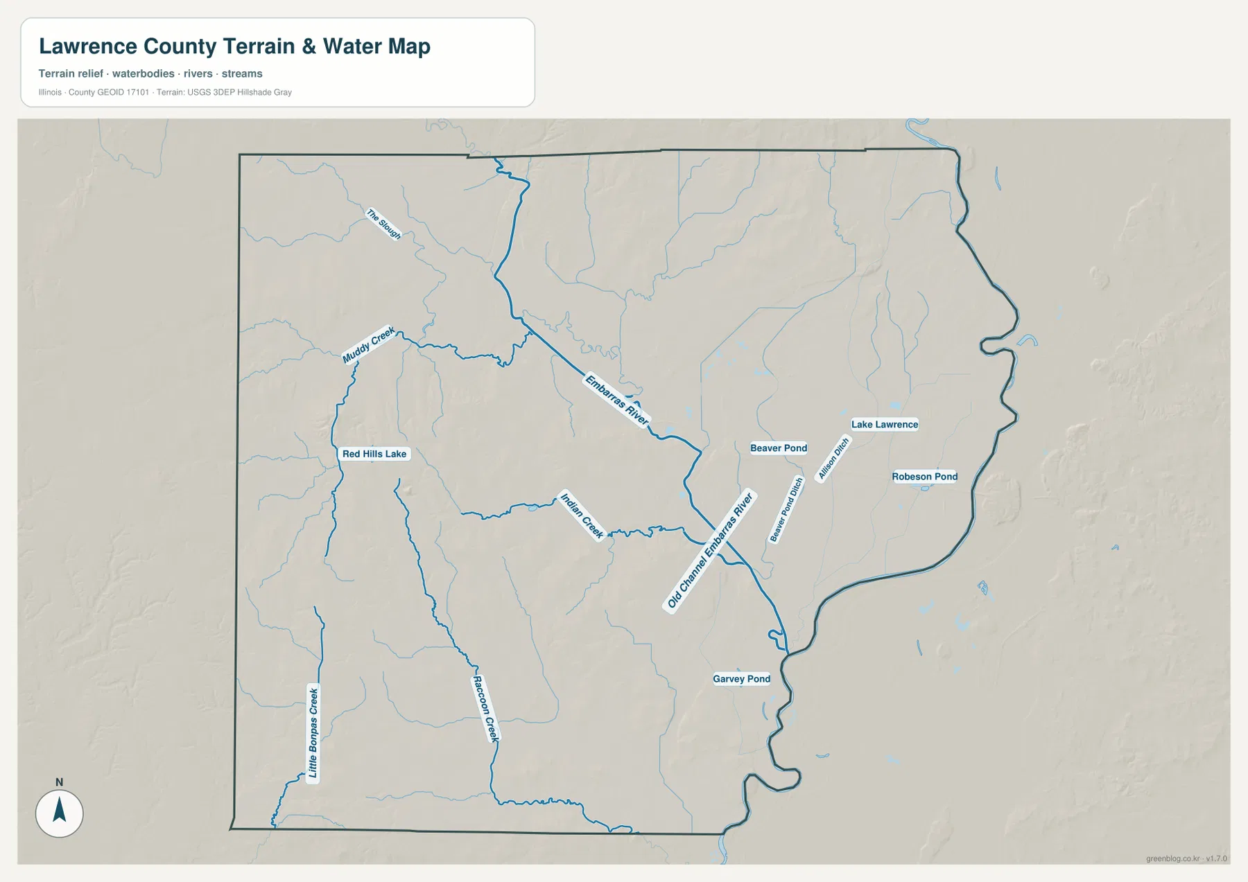
The Embarras River is the strongest internal water reference on the terrain-and-water map. It gathers drainage from the northern and western parts of the county, crosses the central interior, and bends toward the lower eastern side. With most major roads removed, the river becomes more visually important than it appears on the county overview. Keeping Lawrenceville’s location in mind makes the map easier to read because several smaller creeks converge toward the same broad lowland occupied by the Embarras system.
In the northwest, Muddy Creek and a waterway labeled The Slough feed the broader network. Farther south, Indian Creek extends toward the Embarras River, while Little Bonpas Creek and Raccoon Creek run through the southwestern portion of the county. These are not parallel channels on a flat surface; they bend around the rolling ground and shallow valleys shown in the relief. Comparing this map with the elevation layer makes the relationship clear: the western terrain is broken into ridges, and the small streams occupy the lower spaces between them.
Red Hills Lake appears west of the county center near the Sumner side of Lawrence County. The lake is a useful local landmark because it sits in the same hill country described by the Illinois Department of Natural Resources at Red Hills State Park. The park page describes wooded hills, deep ravines, meadows, springs, and a lake, all of which fit the textured terrain visible in the western part of the map. The lake is not a dominant county-scale water body, but it helps connect a named place with the county’s most distinctive high-relief landscape.
Several smaller water features are labeled in the east and southeast, including Lake Lawrence, Beaver Pond, Robeson Pond, and Garvey Pond. Beaver Pond Ditch and Allison Ditch also appear, indicating that the low eastern landscape includes managed drainage channels as well as natural streams. Near the Embarras River, the label Old Channel Embarras River identifies a former channel segment. Those details are useful for understanding why the eastern half of the county contains so many narrow blue lines even where the terrain looks broad and relatively low.
The Wabash River forms the county’s eastern boundary, but this particular water map gives more labeling space to the interior streams and ponds. The irregular outline still follows the river edge and distinguishes it from the straighter boundaries on other sides of the county. This map should be used as a geographic reference rather than as a flood, navigation, wetland-jurisdiction, or property-boundary product. Current water levels, flood zones, and regulated boundaries require the appropriate state or federal source.
The 119–192 m contrast between Red Hills and the eastern lowlands
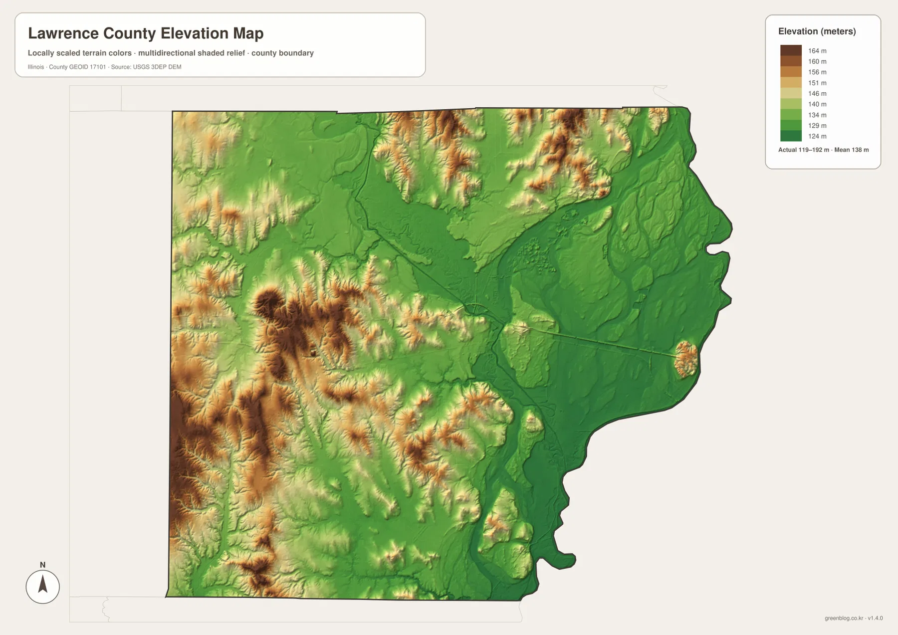
The elevation legend gives an actual county range of about 119 to 192 meters and a mean near 138 meters. The strongest visual contrast is in the west and southwest, where tan and brown ridges rise above narrow green valleys. The Red Hills area near Sumner is part of this rougher country. The eastern half, by comparison, is dominated by broad green lowlands, so the county changes from compact ridges and ravines to gentler terrain over a relatively short east-west distance.
The Embarras River follows one of the most continuous low corridors across the interior. Its valley appears in darker green, and tributaries from the western hills descend toward it. That relationship is much easier to see on the elevation map than on the road map, where the orange route lines naturally attract attention first. When the water and elevation maps are viewed together, the dense creek network in the west makes sense: numerous small valleys cut through the higher ground before joining the lower central drainage system.
East of Lawrenceville, the land becomes lower and generally smoother toward the Wabash River boundary. Large green areas occupy the central-east and southeast, although smaller ridges and local rises are still visible. This is not a perfectly flat surface, but the terrain is less sharply dissected than the western side. The contrast helps explain why the county map looks relatively open around the east-central road corridor while the western water map shows many branching creeks and hill-shadow details.
Red Hills State Park gives the western relief a useful real-world reference. Illinois DNR describes the park as high wooded hills and deep ravines, and the elevation image shows the same kind of closely spaced high and low ground west of the county center. The park is therefore more than a named recreation site in this article; it is a concrete example of the landscape difference that the elevation colors reveal. Moving east from the Red Hills area toward Lawrenceville and the Wabash lowlands produces one of the clearest terrain transitions on the map set.
The elevation layer is intended for regional comparison, not site engineering. Its 119–192 meter range is useful for seeing where land is relatively high or low across Lawrence County, but it should not be used to determine a parcel’s exact elevation, building grade, drainage design, or flood safety. Those tasks require the original USGS elevation data or a professional survey. For general map reading, the practical takeaway is simple: western Lawrence County is hillier, while the central river corridors and much of the east are lower.
Choosing the best Lawrence County map for roads, water, terrain, or printing
For a first look at Lawrence County, start with the county overview. Find Lawrenceville, then follow Route 50 and Route 1 to establish east-west and north-south directions. Add Bridgeport and Sumner to the west and St. Francisville to the southeast. Once those anchors are in place, the irregular Wabash River boundary becomes easy to recognize, and smaller roads and streams can be added without losing the overall orientation.
Use the settlement-connections map when relative location matters more than road detail. It quickly shows that Bridgeport is the closest of the four labeled communities to Lawrenceville at about 4 miles straight-line distance, while Sumner, St. Francisville, and Russellville are each about 10 miles away in different directions. Because these are direct distances, they are useful for spatial comparison but should not be substituted for driving mileage or travel time.
Choose the water map when the Embarras River, Red Hills Lake, Indian Creek, Little Bonpas Creek, or the smaller eastern ponds are the subject. The elevation map then adds a second layer of understanding by showing why the western creek network is so branched and why the eastern half appears broader and lower. For a classroom explanation or a local geography presentation, pairing those two maps often tells the physical landscape story more clearly than either one alone.
The WebP images in the article are optimized for comfortable web viewing. When small labels need to be enlarged, when a map must be printed, or when a larger image is needed for a slide or handout, use the ZIP below. It contains one high-resolution JPG for the county overview, settlement connections, terrain and water, and elevation.
Frequently Asked Questions
Which map is best for comparing Lawrenceville with Bridgeport and Sumner?
Use the county overview together with the settlement-connections map. The overview shows the road corridor running west from Lawrenceville through Bridgeport toward Sumner, while the simplified map gives direct-distance references of about 4 miles to Bridgeport and 10 miles to Sumner. Those distances are straight-line values, not driving mileage.
How can I tell the Embarras River from the Wabash River on these maps?
The Embarras River is labeled inside the county on the terrain-and-water map and crosses the interior drainage system. The Wabash River forms the irregular eastern boundary between Illinois and Indiana. Because the water map emphasizes interior features, the Wabash name is less prominent than the shape of the eastern border itself.
Can the 119–192 m elevation map be used for surveying or flood decisions?
No. The elevation map is designed for county-scale comparison of higher western hills and lower river corridors. Exact parcel elevation, grading, drainage, engineering, or flood decisions require the original elevation data and, where appropriate, a professional survey or official flood map.
Map File Information
The ZIP contains four high-resolution JPG maps of Lawrence County. Use the larger files when you need clearer labels for zooming, printing, classroom work, presentations, or local reference.
- Included Files: 4 high-resolution JPG images
- File Type: ZIP archive containing JPG images
Related Maps
Sources and references
- Lawrence County, Illinois official website – official county information and access to county mapping resources.
- Lawrence County Multi-Hazard Mitigation Plan – Illinois government county profile identifying the Wabash River as the eastern boundary.
- Illinois DNR Red Hills State Park – official description of the Red Hills landscape near Sumner and Lawrenceville.
- U.S. Census Bureau TIGER/Line Shapefiles – official boundary and transportation geography reference.
- USGS National Hydrography – official reference for rivers, streams, lakes, and related hydrography.
- USGS 3D Elevation Program – official elevation and terrain data reference.
Green Map creates custom-edited map images using open geographic data sources such as geoBoundaries, Natural Earth, OpenStreetMap, and government open data.
These maps are edited visual materials, not raw data files, and are provided for education, documents, presentations, and graphic reference.