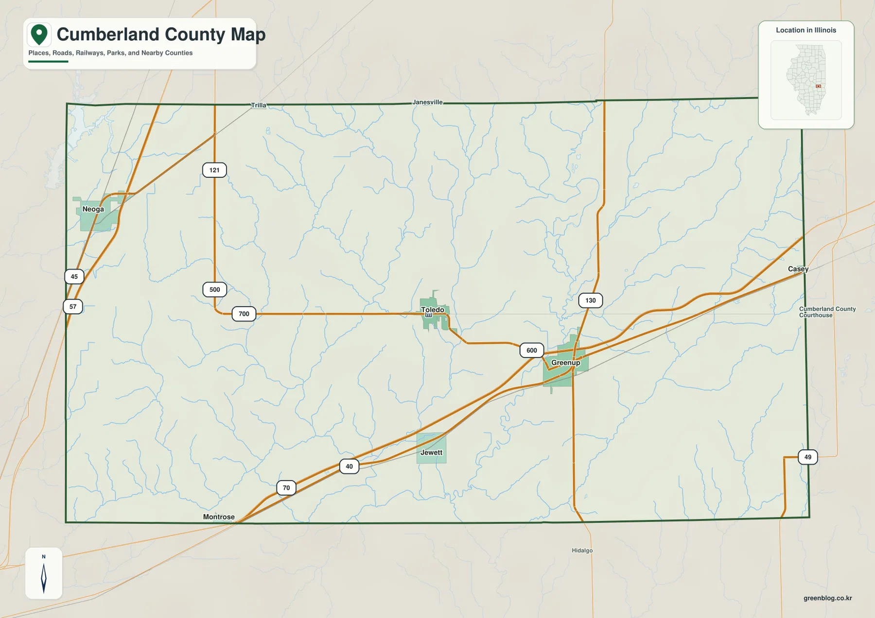
Cumberland County in east-central Illinois is easiest to orient by separating three useful references: Greenup, Toledo, and Neoga. Greenup sits in the eastern-central county near the U.S. 40 and I-70 corridor, Toledo lies to its west and serves as the current county seat, and Neoga occupies the far western side near I-57 and U.S. 45. Jewett is a much smaller place southwest of Greenup. Between those communities, Embarras River and a dense set of creeks cut the county into low valleys and higher rolling ground.
The supplied maps let you follow that geography from roads and town spacing to drainage and relief. One view emphasizes the highway structure, another uses Greenup as a hub for direct-distance comparisons, the terrain image names Embarras River and its tributaries, and the elevation image shows the broad northwest high ground above the central river valleys. High-resolution JPG originals are bundled in one ZIP download, making smaller creek labels, road numbers, and terrain colors easier to inspect or print.
Illinois State Archives records show that Cumberland County was established on March 2, 1843. Greenup served as the first county seat, while Toledo became the seat in 1855 and remains so today. The county comprehensive plan also gives Greenup an important transportation history: the Cumberland Road, later recognized as the National Road, helped drive early settlement and growth through this part of the county.
Table of Contents
Major roads separate Neoga, Greenup, and the county seat
At the western edge, Neoga sits beside the north-south I-57 and U.S. 45 corridor. Route 121 appears just to the east. Across the southern half of the county, I-70 and U.S. 40 run diagonally from southwest to northeast toward Greenup. Route 130 crosses near Greenup, and Route 49 appears close to the far eastern boundary. These roads make the two sides of the county easy to recognize even before the smaller local network is considered.
Toledo lies west of Greenup along the interior road system, while Jewett sits southwest of the hub and north of the I-70/U.S. 40 corridor. The result is not a single-city pattern. Neoga controls the western highway reference, Toledo provides the administrative center, and Greenup is the eastern transportation and historic-road reference. Keeping those roles separate makes the map more useful than treating the largest printed road junction as the county seat.
Greenup adds a historical layer to the road map. The Village of Greenup describes the Jackson Truss Covered Bridge over Embarras River as part of the Old National Road corridor, with access near Highway 40. The modern highway and the older Cumberland Road story therefore meet in the same area where the map shows Greenup and the river close together.
Toledo, not Greenup, is the current county seat
Illinois State Archives lists Greenup as the county seat from 1843 to 1855 and Toledo from 1855 to the present. Toledo was historically known as Prairie City. Current Cumberland County offices are also located in Toledo. Greenup’s hub role on the city-connections graphic should therefore be understood as a map-design choice rather than an administrative designation.
Greenup hub distances put Toledo, Jewett, and Neoga in perspective
The city-connections graphic uses Greenup as the hub. Toledo is shown about 5 miles to the west, Jewett about 5 miles to the southwest, and Neoga about 17 miles away on the western side. The panel explicitly labels these as direct distances, so the values represent straight-line separation between mapped points rather than road mileage or estimated drive time.
The same panel prints CITY CONNECTIONS values of 1,823 for Greenup, 1,421 for Neoga, 1,197 for Toledo, and 251 for Jewett. No census year or statistical reference date appears next to those numbers. This page therefore treats them only as undated values supplied with the graphic, not as current population counts. The direction and direct-distance labels are the clearer geographic information.
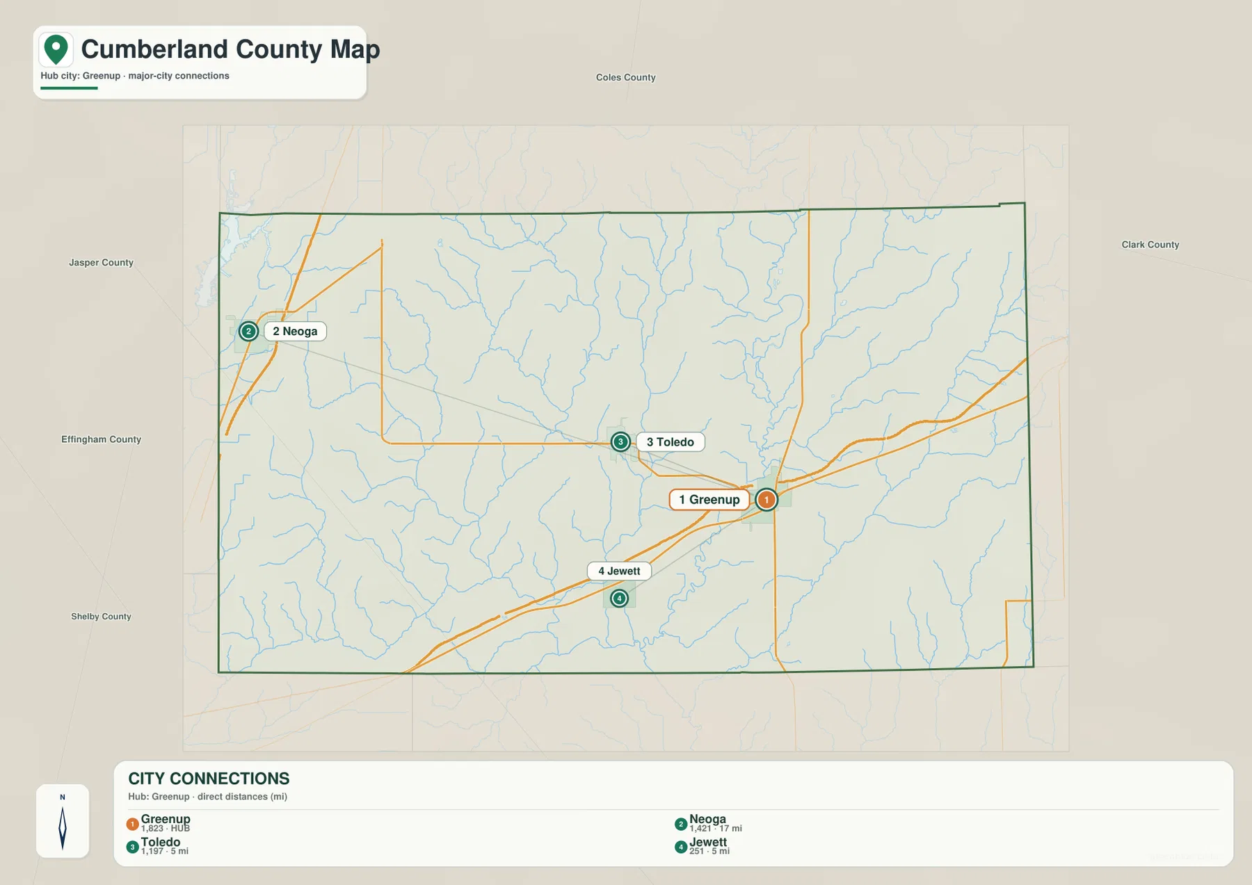
The spacing explains why Greenup works well as a hub even though Toledo is the county seat. Toledo and Jewett are close to Greenup, while Neoga sits much farther across the county. Actual driving distance can be longer than the drawn segments because roads do not follow straight lines between each pair. Current navigation or transportation data should be used for trip mileage.
Direct distance and undated index values need different uses
The 5- and 17-mile labels are straight-line distances, while the four CITY CONNECTIONS numbers are undated map values. Road mileage belongs in a current routing source, and present-day population should come from a dated Census release. The supplied city graphic is best used for relative position and spacing.
Embarras River and Cottonwood Creek organize the central drainage
Embarras River is the largest named channel on the terrain-and-water map. It runs through the central-southern county, receiving drainage from a branching network above it. Cottonwood Creek forms a long central valley from the north, while Clear Creek and Hurricane Creek occupy separate branches farther east. Lost Creek and Range Creek add long drainage lines across the eastern half.
The western side has its own dense network. Long Point Creek and Bear Creek appear in the northwest-to-central country, while Mule Creek and Muddy Creek descend through the west-central side. Oliver Branch lies close to Muddy Creek. Spring Point Creek reaches the southwest, where Woodbury Lake provides the clearest named still-water reference on the map.
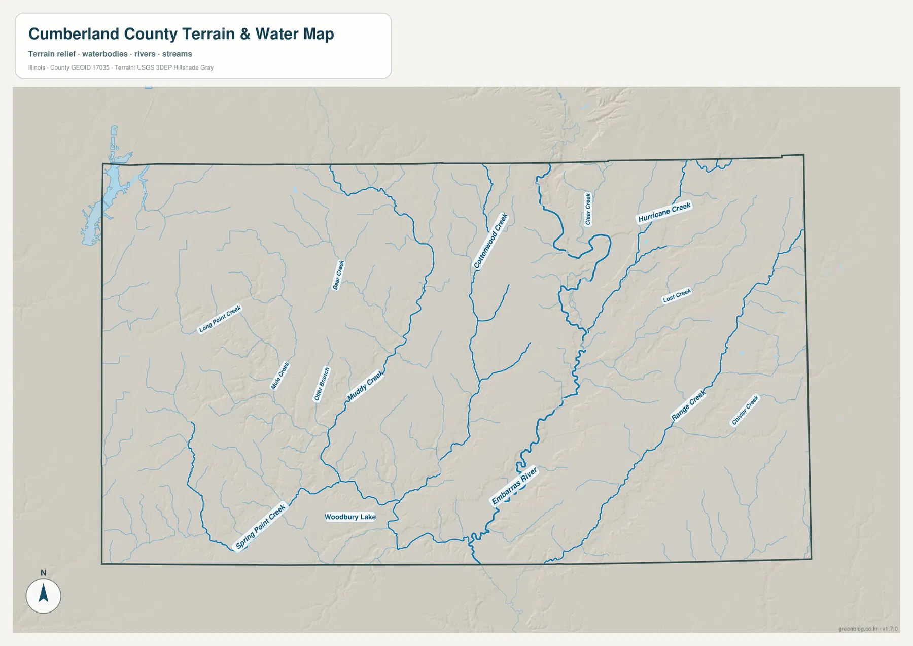
The county comprehensive plan links this river landscape to local history, noting that early settlers first occupied wooded bluffs along Embarras River. Greenup’s covered bridge provides a second local example where the Old National Road crosses the river. Those references reinforce what the supplied map shows: the Embarras corridor is both a physical lowland and a long-standing feature in the county’s settlement and transportation story.
Stream location is not current flood information
The water sheet locates rivers, creeks, a lake, and surrounding relief at county scale. It does not report current Embarras River stage, flood-hazard boundaries, water depth, bridge status, or legal access. Current USGS, county, and state information should be used whenever the question depends on present conditions or safety.
Northwest high ground drops into the Embarras corridor
The elevation image gives Cumberland County a strong northwest-to-central contrast. Broad brown and orange high ground covers the northwest, but green creek valleys cut deeply into it. The central drainage becomes lower toward Embarras River, which forms the broadest connected green corridor through the middle and south. Farther east, the land rises again into yellow and orange rolling terrain between the creek valleys.
The map prints an actual countywide elevation range of about 152 to 216 meters and a mean near 185 meters. Its legend uses narrower color bands from roughly 159 to 203 meters, while the separate “Actual” line records the full dataset minimum and maximum. Those endpoints describe Cumberland County as a whole and should not be assigned directly to Greenup, Toledo, Neoga, or any individual property.
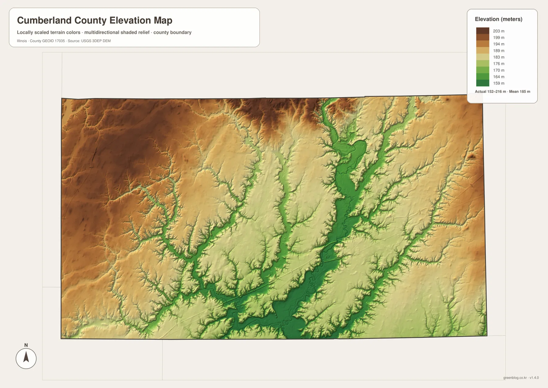
Comparing the elevation and water maps makes the low corridors easy to match. Cottonwood Creek and Muddy Creek occupy green cuts through higher ground, and Embarras River forms the larger connected lowland toward the south. Range Creek and Spring Point Creek also follow lower terrain between surrounding ridges. The result is a gently rolling county whose relief becomes much more visible once the road layer is removed.
152 to 216 meters is a countywide range
A building site, road grade, drainage plan, or parcel needs point-specific elevation data or a professional survey. The 152–216 meter range is most useful for comparing the broad northwest upland with Embarras River and tributary lowlands, not for assigning an exact elevation to a named town or street address.
Use Greenup and Toledo as separate reference points
A practical way to use the files is to give Greenup and Toledo different jobs. On the overview, Greenup anchors the I-70/U.S. 40 side while Toledo marks the county seat farther west; Neoga adds the I-57/U.S. 45 edge. The city graphic then makes the spacing concrete by showing Toledo and Jewett about 5 direct miles from Greenup and Neoga about 17 miles away.
Next, locate Embarras River and Cottonwood Creek on the terrain sheet, then compare the same positions with the elevation colors. The Greenup-side river corridor sits below surrounding rolling ground, while the Neoga direction reaches into the broad northwest upland. Using the same town references across roads, water, and relief keeps Cumberland County’s geography connected rather than turning each image into a separate exercise.
Use current transportation sources for driving distance, dated Census data for population, water agencies for river or flood questions, and point-level elevation or survey data for site work. Within those limits, the Cumberland County maps are useful for printed references, lessons, presentations, and advance geographic orientation.
Frequently Asked Questions
What is the county seat of Cumberland County, Illinois?
Toledo is the current county seat. Illinois State Archives lists Greenup as the seat from 1843 to 1855 and Toledo from 1855 to the present. Greenup is labeled as the hub on the supplied city-connections graphic, but that map role is separate from the county-seat designation.
Is the 17-mile Greenup-to-Neoga label driving distance?
No. The city-connections graphic identifies about 17 miles to Neoga, 5 miles to Toledo, and 5 miles to Jewett as direct distances from Greenup. Actual road mileage can differ and should be checked with a current routing source.
Does 152 to 216 meters give Greenup’s elevation?
No. The elevation image identifies 152–216 m as the actual range across the Cumberland County dataset and gives a mean of about 185 m. Exact elevation for Greenup or any specific road, building, or property requires point-specific elevation or survey data.
Sources and Reference Material
The article uses the supplied Cumberland County maps together with the official and local references below. For current road conditions, Embarras River stages, legal boundaries, or exact point elevations, consult the responsible agency’s latest material rather than relying on a static county reference map.
- Cumberland County Official Website – current county government and Toledo office information
- Illinois State Archives – Cumberland County – county establishment, name origin, and Greenup-Toledo county-seat history
- Cumberland County Comprehensive Plan – National Road, Greenup and Neoga history, and Embarras River regional context
- Village of Greenup – Tourism & Attractions – Jackson Truss Covered Bridge, Old National Road, and Embarras River context
- USGS National Hydrography – river, stream, and lake reference data
- USGS 3D Elevation Program – elevation and terrain data
Map File Information
The ZIP file contains the high-resolution JPG originals for the Cumberland County overview, city-connections map, terrain-and-water map, and elevation map. Each landscape image measures 3,638 × 2,572 pixels, preserving town labels, road numbers, smaller creek names, and elevation colors more clearly when enlarged or printed.
- Included Files: 4 high-resolution JPG maps
- Printable Size: 3,638 × 2,572 pixels each
Related Maps
Green Map creates custom-edited map images using open geographic data sources such as geoBoundaries, Natural Earth, OpenStreetMap, and government open data.
These maps are edited visual materials, not raw data files, and are provided for education, documents, presentations, and graphic reference.