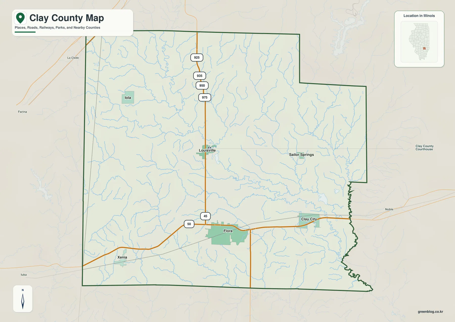
Clay County in southeastern Illinois is easiest to learn by connecting Louisville and Flora first. Louisville sits north of the county’s midpoint, while Flora lies farther south where the main north-south and east-west road corridors meet. Xenia is west of Flora, Clay City is east, Iola is northwest, and Sailor Springs is farther east. Between those places, Little Wabash River and a dense group of creeks divide the landscape into low valleys and higher rolling ground.
The four supplied images follow that geography from different angles without requiring the reader to memorize separate map types. Start with the Louisville-Flora road relationship, then compare the six labeled communities, trace the Little Wabash and its tributaries, and finally match those valleys with the 121–195 meter countywide elevation range. High-resolution JPG originals are bundled in one ZIP download, preserving smaller waterway labels and terrain colors when the maps are enlarged or printed.
Clay County’s official site says the county was formed on December 23, 1824 from parts of Wayne, Crawford, and Fayette counties and was named for Henry Clay. Illinois State Archives records identify Louisville as the present county seat after the earlier seat at Maysville. On the map, Louisville’s position along the north-south road through Flora makes it both an administrative reference and a practical geographic anchor.
Table of Contents
US 45 links Louisville with Flora
The county overview has one especially useful organizing line: the north-south road through Louisville and Flora. North of Louisville, several numbered local routes appear along the same corridor. Southbound, the road reaches Flora and meets the major east-west route marked 50. That junction turns Flora into the easiest place to compare north-south and east-west movement at the same time.
Following the east-west road from Flora reaches Xenia to the west and Clay City to the east. Flora also has the broadest urban footprint on the overview, while Louisville forms a separate center farther north. Iola lies in the northwest and Sailor Springs is east of Louisville, giving the map two smaller outer references. Once those six places are located, the county’s width and orientation become much easier to remember.
The blue drainage lines explain why the landscape cannot be reduced to the road grid. Little Wabash River passes near the Louisville side of the county and continues through the center, while many tributaries cross the country around Flora and Clay City. Western ground near Xenia and Iola appears more broken by short ridges, whereas lower creek valleys become more common toward the central and eastern parts of the county.
Louisville is the current county seat
Illinois State Archives local-government records list Clay County as established in 1824 with Louisville as its county seat. Historical state materials place the earlier seat at Maysville from 1825 to 1841 before Louisville took over. That history gives Louisville a role distinct from Flora’s larger mapped urban footprint: one is the county’s administrative center, while the other is the strongest road-and-settlement reference on the supplied overview.
Six city labels show Flora as the largest map reference
The simplified city image ranks Flora first, Louisville second, Clay City third, Xenia fourth, Iola fifth, and Sailor Springs sixth. Its CITY INDEX prints 4,475 for Flora, 1,163 for Louisville, 723 for Clay City, 389 for Xenia, 90 for Iola, and 60 for Sailor Springs. The graphic does not show a census year or statistical reference date beside those numbers.
Because the index is undated, the values are not treated here as current population counts. Their map function is still useful. Flora anchors the southern middle, Louisville is north of it, Clay City lies east, Xenia southwest, Iola northwest, and Sailor Springs farther east. The six points spread widely enough to provide a quick mental outline of Clay County before roads and creek names are added back.
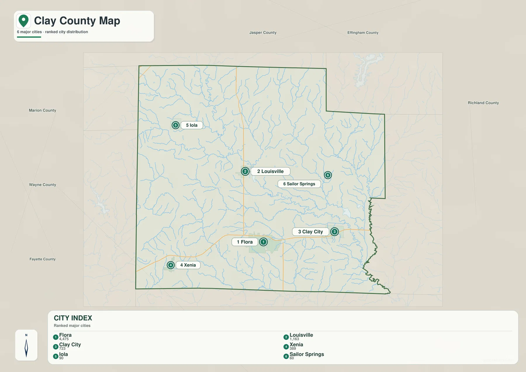
The stripped-down city layout also makes the road geography easier to recall later. Louisville and Flora line up on the main north-south corridor, while Xenia and Clay City sit on opposite sides of Flora along the east-west route. Iola and Sailor Springs mark quieter outer areas where streams and rolling terrain are more visually prominent than dense development.
Use dated Census data for current population
A current population table needs a source with an explicit reference year, such as a U.S. Census Bureau release. The supplied CITY INDEX does not provide that date. On this page it is used only to explain the ranking printed on the image and the relative placement of the six communities.
Little Wabash River organizes the central drainage
The terrain-and-water view puts Little Wabash River at the center of Clay County’s drainage story. The river descends from the north, bends through the middle of the county, and continues southeast. Crooked Creek approaches from the west, Panther Creek lies in the north-central area, and Little Muddy Creek with Big Muddy Creek occupies separate valleys on the eastern side. Their branching pattern is much more obvious here than on the road-focused overview.
Farther south, Buck Creek and Elm Creek form long drainage lines, while Raccoon Creek and Big Creek are labeled in the southwest. The map also names several smaller water bodies: Mc Arthur Lake and Patterson Lake in the northwest, Trago Lake in the south-central to southwestern area, and Gaskin Lake in the east. Those lakes provide useful fixed points inside a county dominated by moving creek and river lines.
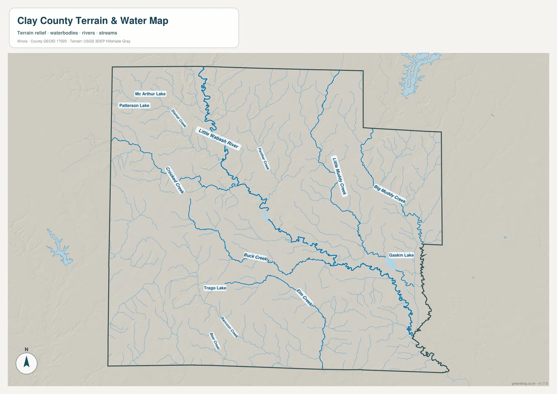
The river’s local importance is supported by USGS monitoring locations at Louisville and below Clay City. The Clay City side also has a distinctive protected wetland nearby: Illinois DNR describes Flag Pond Land and Water Reserve, about 3 miles northeast of Clay City, as containing a 35-acre high-quality pond along with wet floodplain forest and upland forest. Those official local references fit the map’s picture of eastern Clay County as a landscape shaped by low drainage corridors, ponds, and floodplain environments.
Water location is not the same as current flood information
The water image identifies rivers, creeks, lakes, and surrounding relief, but it does not show today’s Little Wabash stage, flood-hazard boundaries, water depth, levee condition, or legal access. USGS water data and the responsible state or local agencies should be consulted when the question depends on current conditions rather than simple geographic location.
Western uplands fall into the Little Wabash lowlands
The elevation image gives Clay County a strong west-to-east and upland-to-valley contrast. Brown and orange terrain is most common in the west and northwest, but the Little Wabash corridor cuts a long green lowland through the middle. Much of the eastern half is also lower, with darker green channels following Big Muddy Creek and other tributaries. Small higher pockets return in the southwest, so the county is not a simple one-direction slope.
The printed “Actual” range is about 121 to 195 meters, with a mean near 148 meters. The color legend itself uses narrower bands from roughly 127 to 170 meters, so the legend and the full dataset range should not be confused. The low and high endpoints summarize the countywide surface; they are not exact elevations for Flora, Clay City, Iola, Xenia, or any single property.
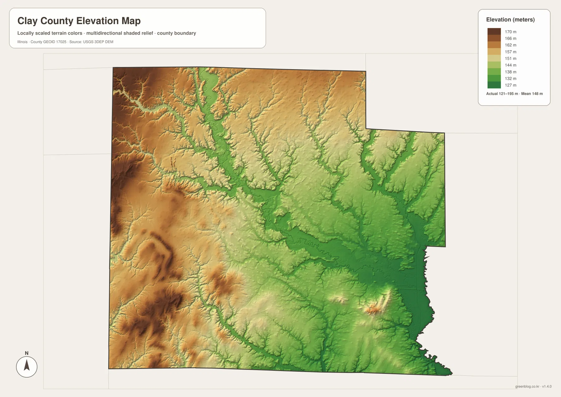
Matching the elevation and water images makes the green bands easier to interpret. Crooked Creek and Panther Creek descend through the higher western terrain toward Little Wabash River, while Little Muddy and Big Muddy creeks occupy lower eastern country. A local nature preserve adds another piece of context: Illinois DNR describes Martin T. Snyder Memorial, southwest of Flora, as a sandstone cliff and dry-mesic upland forest site, consistent with the rougher relief visible on the western side of the county.
Countywide relief is not a site survey
A building lot, road profile, drainage design, or engineering project needs point-specific elevation data or a professional survey. The 121–195 meter range is useful for comparing western uplands with the Little Wabash and eastern creek lowlands, not for assigning an exact elevation to a street address.
Follow Louisville, Flora, and the Little Wabash across the map set
A practical way to use the files is to keep the same references while changing layers. Begin with Louisville and Flora on the road map, then follow the east-west route through Xenia and Clay City. The city graphic removes most of the detail and confirms how the six labeled communities are spaced. On the water map, Little Wabash River becomes the main central reference, with the Clay City side opening into additional muddy-creek and pond country.
The elevation colors complete the picture. Higher western ground around the Iola-Xenia side gives way to the lower Little Wabash valley, while the eastern half remains cut by low tributary corridors. Seeing those relationships together explains why two places connected by a fairly simple road grid can occupy different local terrain and drainage settings.
Use current transportation data for actual road conditions, dated Census releases for population, agency water information for river stage or flood questions, and point-level elevation sources for site work. Within those boundaries, the Clay County maps provide a useful county-scale reference for teaching, presentations, printed materials, and advance geographic orientation.
Frequently Asked Questions
What is the county seat of Clay County, Illinois?
Louisville is the current county seat. Illinois State Archives records identify Louisville as the county seat, and state historical material places the earlier seat at Maysville before the move to Louisville in 1841.
Does Little Wabash River pass near Louisville and Clay City?
Yes. The supplied terrain-and-water map shows Little Wabash River running through the county near the Louisville side and continuing southeast. USGS also maintains monitoring-location records for Little Wabash River at Louisville and below Clay City, confirming the river’s importance to both parts of the county.
Does 121 to 195 meters give Flora’s elevation?
No. The elevation image identifies 121–195 m as the actual range across the Clay County dataset and gives a mean of about 148 m. Exact elevation for Flora or any specific road, property, or structure requires point-specific elevation or survey data.
Sources and Reference Material
The article uses the supplied Clay County maps together with the official references below. For current Little Wabash River conditions, road information, protected-area rules, or exact point elevations, consult the responsible agency’s latest material rather than relying on a static county reference map.
- Clay County Official Website – county formation, Henry Clay name origin, and local government information
- Illinois State Archives – Clay County Local Government Index – county establishment and Louisville county-seat record
- USGS – Little Wabash River at Louisville – official monitoring-location record in Clay County
- Illinois DNR – Flag Pond Land and Water Reserve – wetland and floodplain natural-area information northeast of Clay City
- USGS 3D Elevation Program – elevation and terrain data
Map File Information
The ZIP file contains the high-resolution JPG originals for the Clay County overview, city map, terrain-and-water map, and elevation map. Each landscape image measures 3,638 × 2,572 pixels, keeping Louisville-Flora road labels, smaller creek names, and elevation colors clearer when enlarged or printed.
- Included Files: 4 high-resolution JPG maps
- Printable Size: 3,638 × 2,572 pixels each
Related Maps
Green Map creates custom-edited map images using open geographic data sources such as geoBoundaries, Natural Earth, OpenStreetMap, and government open data.
These maps are edited visual materials, not raw data files, and are provided for education, documents, presentations, and graphic reference.