Shoshone County stretches through a large block of mountain country in northern Idaho, yet most of the familiar towns occupy a narrow strip near Interstate 90. Kellogg, Osburn, Wallace, Mullan, Pinehurst, and Smelterville sit close together in the Silver Valley, while the county extends far south into the headwaters of the St. Joe and Clearwater systems. That contrast between a compact northern town corridor and a much larger mountain interior is the easiest way to understand the maps on this page.
The page includes a county road-and-boundary map, a simplified city map, a terrain-and-water map, and an elevation map. High-resolution JPG originals of the same four views are available in one ZIP from the Map File Information box below. The downloadable files are a better choice than a browser screenshot when you need readable labels for an A3 print, classroom handout, presentation, or report.
Each map answers a different question. The county overview shows where I-90 and the major town corridor sit inside the long county boundary. The city map makes the Silver Valley cluster easy to compare. The terrain-and-water view follows the Coeur d’Alene, St. Joe, and Clearwater headwaters through the mountains, and the elevation view shows how sharply low valleys and high ridges alternate across the county.
Table of Contents
I-90 and the narrow Silver Valley town corridor
The county overview immediately shows that the main settled corridor occupies only a small part of Shoshone County. Interstate 90 crosses the north from west to east, passing the cluster around Kellogg and Osburn before continuing toward Wallace and Mullan. South of that route, town labels become scarce and the map shifts toward winding local roads, streams, and mountain terrain.
The county boundary reinforces the same point. It is relatively narrow near the Silver Valley but extends a long distance south and southeast, enclosing a broad backcountry area. Several numbered roads reach into that interior, but a route number alone does not make them equivalent to I-90 in road type or travel conditions. For a general map, their main value is showing how access follows valleys and branches into the mountains.
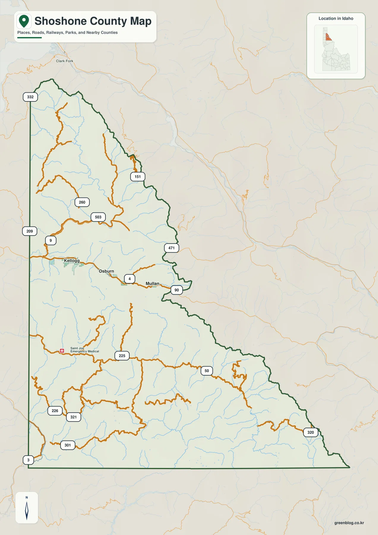
Neighboring county and state labels provide regional context, but the internal scale difference is the most useful feature. Once the northern towns are located, following the boundary south makes it obvious how much of Shoshone County lies beyond the Silver Valley. This is useful when a report or lesson needs to show that the county is not simply a chain of I-90 towns; those communities are one concentrated part of a much larger mountain county.
Use Wallace as a reference point
Wallace, the county seat, is a convenient reference point for the eastern Silver Valley. Osburn and Kellogg lie to the west, while Mullan is farther east. Pinehurst and Smelterville sit toward the western side of the same general cluster. Remembering that order makes it easier to switch between the city map and the fuller county map without losing track of direction.
Wallace also helps illustrate the difference between the traveled valley corridor and the mountain interior. A reader can find Wallace on I-90, then trace the county boundary far south into areas where river names and relief become more prominent than town names.
Six labeled communities in one northern valley
The city map focuses on Kellogg, Pinehurst, Osburn, Wallace, Mullan, and Smelterville. Pinehurst and Smelterville occupy the western side of the group, Kellogg and Osburn sit through the middle, and Wallace and Mullan continue eastward. Removing most of the road detail makes the sequence much easier to grasp than it is on a dense basemap.
The absence of comparable city markers across most of the southern county is just as informative. Shoshone County extends far beyond the town cluster, but the named urban places shown here remain concentrated in a narrow northern band. The map is therefore useful for explaining settlement location, not for suggesting that development is evenly spread across the county.
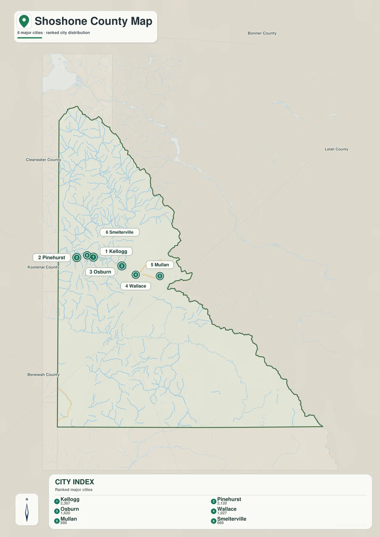
If numeric values appear beside city labels, they should not be treated as current population figures unless the source date is independently verified. On this page, the dependable information is positional: which communities are shown, their west-to-east order, and how tightly they are grouped. For current population estimates, use the latest U.S. Census Bureau or local government releases.
Straight-line separation is not driving distance
Any connector or distance value between city markers should be read as straight-line separation rather than a road itinerary. Mountain highways and local roads have to follow valleys, river bends, and grades, so the actual driving route can be longer than the simple distance shown between two points. The city map is best for orientation; current navigation and road-condition sources should be used for a real trip.
This distinction matters especially in a county where narrow valleys shape travel. Two communities may look close on a simplified graphic while the practical route still has to follow the I-90 corridor or another valley road. Use the map to understand direction and relative position, not to estimate travel time.
Coeur d’Alene headwaters in the north, St. Joe and Clearwater to the south
The terrain-and-water map changes the emphasis from towns to rivers and mountain valleys. In the north, the North Fork Coeur d’Alene River and South Fork Coeur d’Alene River are prominent labels, with smaller tributaries descending from the surrounding ridges. The Silver Valley town corridor lies close to the South Fork, which helps explain why roads and communities line up along the same low passage through the mountains.
Farther south, the St. Joe River and North Fork St. Joe River become major reference features. Still farther south, the Little North Fork Clearwater River appears in a separate headwater area. This north-to-south change is important because Shoshone County does not belong to one single river corridor; its long shape reaches across mountain headwaters that ultimately connect with different larger river systems.
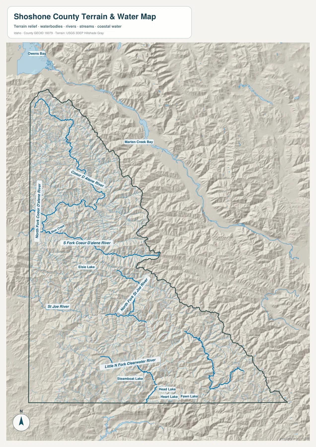
Small named lakes also provide useful reference points in the remote southern interior. Steamboat Lake, Head Lake, Heart Lake, and Fawn Lake are shown among the mountain drainage features. These are modest features compared with the large river labels, but in areas with few towns they help a reader identify which part of the southern county is being viewed.
Use the water map for location, not live river conditions
This map is a geographic reference for river, tributary, lake, and terrain location. It is not a flood forecast, a real-time stream gauge, a water-quality report, or a navigation chart. Current river levels, flood hazards, closures, and other changing conditions should be checked through the responsible agency before making a decision that depends on present conditions.
The scale also means that not every small creek, pond, or seasonal drainage can be expected to appear. A detailed recreation, trail, fishing, or site-planning question calls for a more specialized map. For county-scale orientation, however, the named rivers and lakes provide a clear framework.
From low river valleys to 2,331-meter mountain ridges
The elevation map gives a countywide range of about 651 to 2,331 meters, with an average near 1,295 meters. Lower terrain appears in green, while yellow and brown tones mark progressively higher ground. The color pattern is more informative than the average alone because it shows low valleys repeatedly cutting through broad areas of high mountain terrain.
The Silver Valley appears as one of those lower corridors. Comparing the elevation map with the city map makes the concentration of Kellogg, Osburn, Wallace, and Mullan easier to understand: the communities occupy a narrow lower passage bordered by higher slopes and ridges. South of the town corridor, high terrain becomes more extensive, but long green valleys continue to follow major streams through the mountains.
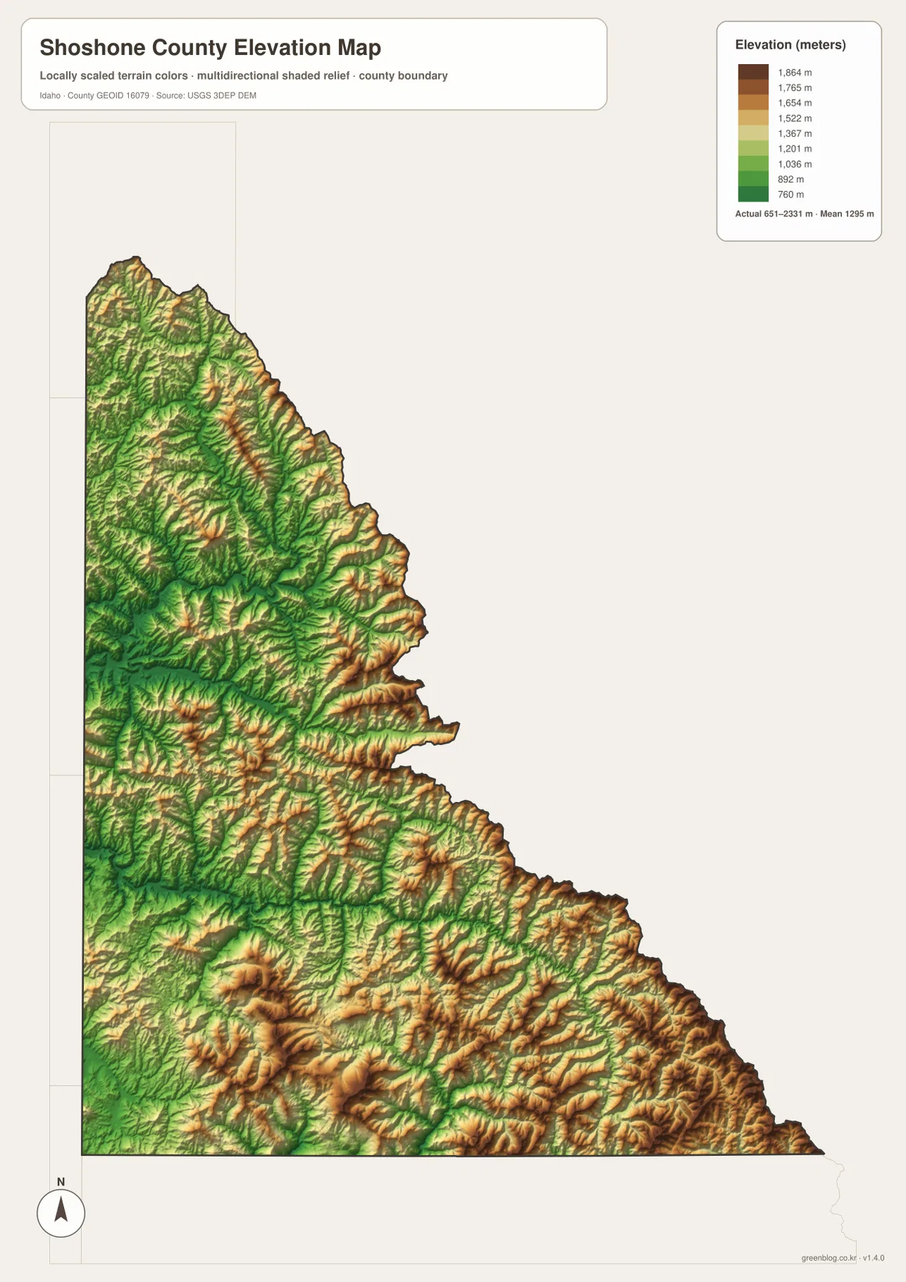
Looking back at the terrain-and-water map, the St. Joe and Clearwater headwaters make more sense in this relief pattern. Rivers occupy lower routes between ridges, and many roads also bend through those valleys instead of crossing high ground in a straight line. The map does not give the grade of a particular road, but it provides useful context for why travel corridors curve through the county.
Elevation colors are for regional comparison, not site surveying
The elevation image is designed to compare broad low and high areas across the county. It should not be used as an exact elevation for a property, construction site, road project, or other location where precise measurements matter. Those tasks require original elevation data at a suitable resolution and, when necessary, professional surveying.
Choosing the right map for a Shoshone County project
Start with the county overview when boundary shape, I-90, road connections, and the overall relationship between towns and backcountry matter. Add the city map when the order of the Silver Valley communities is the main point. Together, those two images make a clear introduction to where people and major travel routes are concentrated.
For a natural-landscape explanation, use the terrain-and-water map with the elevation view. The river names identify the Coeur d’Alene, St. Joe, and Clearwater headwater areas, while the elevation colors show the valleys and high ridges around them. This pairing works well in geography lessons, regional descriptions, and reports that need to explain why roads and towns occupy only a limited number of mountain corridors.
For printing, one or two large maps are usually more readable than four small thumbnails on a single page. Choose the county map when road numbers and boundary shape matter, the city map for town location, the water map for named rivers and lakes, and the elevation map for relief. The downloadable JPG files retain more label detail than a screen capture.
Each graphic also has a clear limit. The county map is not a parcel or turn-by-turn navigation product, the city map is not a live population table, the water map is not a flood forecast, and the elevation view is not an engineering surface. Used for their intended purpose, they provide a practical county-scale picture of Shoshone County’s towns, rivers, valleys, and mountain relief.
Frequently Asked Questions
Why are most major towns in northern Shoshone County?
Kellogg, Osburn, Wallace, Mullan, Pinehurst, and Smelterville are concentrated in the narrow Silver Valley, where lower terrain creates a practical corridor through the surrounding mountains. I-90 follows the same general passage. Comparing the city and elevation maps makes the concentration of towns in this northern strip especially clear.
How can I distinguish the Coeur d’Alene and St. Joe headwaters?
Start in the north with the North Fork and South Fork Coeur d’Alene River. Move south and the St. Joe River and North Fork St. Joe River become the main labels, followed still farther south by the Little North Fork Clearwater River. Reading the map from north to south makes the separate headwater areas easier to follow.
Is the 651-to-2,331-meter range an exact site elevation?
No. The range summarizes the broad relief shown across the county. It is useful for comparing low valleys with high ridges, but a property, construction site, road project, or other precise location requires original elevation data at an appropriate resolution and, when necessary, professional survey measurements.
Map File Information
The ZIP contains the high-resolution JPG originals for the Shoshone County overview, city, terrain-and-water, and elevation maps shown on this page. Each JPG is 2,572 × 3,638 pixels, giving you more readable detail for print and large document layouts than an on-screen capture.
- Included Files: 4 high-resolution JPG maps
- Printable Size: 2,572 × 3,638 pixels each
Related Maps
Sources and reference data
The descriptions above are based on the supplied Shoshone County maps and the official references below. For current administrative details, legal boundaries, live river conditions, or high-precision elevation work, use the responsible agency’s latest data rather than relying on the finished reference graphics alone.
- Shoshone County Idaho official website – county government information and local background
- Shoshone County All-Hazard Mitigation Plan – county geography and elevation background
- U.S. Census Bureau TIGER/Line Shapefiles – county boundaries and geographic reference data
- USGS National Hydrography – rivers, streams, lakes, and hydrographic reference data
- USGS 3D Elevation Program – elevation and DEM program information
These maps are intended for education, documents, presentations, printing, and general geographic reference. They do not replace legal boundary records, current road navigation, flood-hazard products, engineering datasets, or professional surveys when an exact decision depends on those specialized sources.
Green Map creates custom-edited map images using open geographic data sources such as geoBoundaries, Natural Earth, OpenStreetMap, and government open data.
These maps are edited visual materials, not raw data files, and are provided for education, documents, presentations, and graphic reference.