Jefferson County in eastern Idaho stretches from the Rigby area toward the open country around Mud Lake, with roads, towns, canals, lakes, and broad changes in elevation visible across the county. This Jefferson County Idaho Map page is built for readers who want both an on-page reference and files they can save: the county, city, water, and elevation maps are shown below, and the matching high-resolution JPG originals are available together in a downloadable ZIP package.
The county is easiest to understand by comparing its southeast and northwest. Rigby and Ririe sit in the more closely settled southeastern area, where the Snake River, Spring Creek, Market Lake, and multiple named canals create a dense set of blue lines on the water map. Mud Lake anchors a different group in the northwest with Camas Creek, Beaver Creek, Sandhole Lake, and Jefferson Canal. Large areas between these places look comparatively open on the general map.
The elevation view adds another layer to that contrast. Much of Jefferson County is shown as broad lower terrain, but several isolated areas rise well above it. Looking at the maps separately keeps the labels readable: use the general map for boundaries and roads, the city view for community locations, the water map for streams and canals, and the elevation map to compare lower ground with the county’s higher features.
Table of Contents
Starting with Rigby, the county boundary, and numbered roads
Rigby is one of the clearest reference points on the general county map. Ririe lies to its east, Lewisville is nearby to the northwest, and Roberts is farther west. Hamer appears much farther north, while Mud Lake is separated from the Rigby-area communities in the west-central part of the county. The spacing immediately shows that Jefferson County’s named places are not distributed evenly from one edge to the other.
The county outline is also irregular enough to matter when reading the map. The northern section is broad, but the boundary changes direction repeatedly toward the east and southeast, ending in a thinner extension at the lower-right side. Because of that shape, Rigby and Ririe sit relatively close to the eastern edge, whereas Mud Lake is surrounded by a much broader area inside the western part of the county.
Several route numbers provide quick orientation. Route 15 runs north-south past Hamer and Roberts, and 33 crosses the middle portion of the county from the Mud Lake side toward the Rigby area. The southeast also shows 20, 48, and 300, while 22 and 28 appear toward the northwest. These labels help establish where places lie, but the image is not a live navigation map; current closures, road conditions, turn-by-turn directions, and travel times require current transportation information.
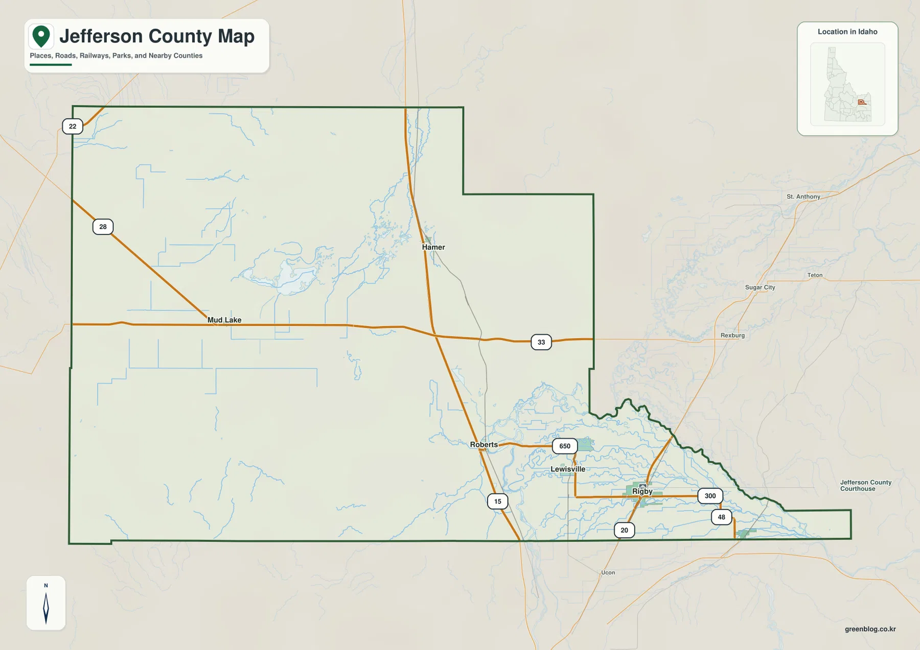
Faint labels outside the county, including Rexburg, Sugar City, St. Anthony, and Ucon, are useful for regional context but should not be read as a list of Jefferson County communities. For a legal boundary decision, parcel research, or another task that depends on exact jurisdiction, the map should be paired with current county or Census boundary data.
How the named communities spread from Rigby toward Mud Lake
The city distribution map removes much of the road and water detail and gives six communities the strongest emphasis: Rigby, Ririe, Menan, Roberts, Mud Lake, and Lewisville. Rigby is in the southeast, with Ririe farther east. Menan sits northwest of Rigby, Roberts lies farther west, and Lewisville occupies an intermediate position. Mud Lake is the outlier, set well apart in the west-central portion of the county.
That simplified view is useful when the question is about direction rather than routing. The cluster around Rigby makes the southeastern side look more closely settled, while Mud Lake establishes a separate reference point across the county. Roberts and Lewisville help bridge the visual gap, but the map still makes clear that the county’s named communities do not form one continuous urban strip.
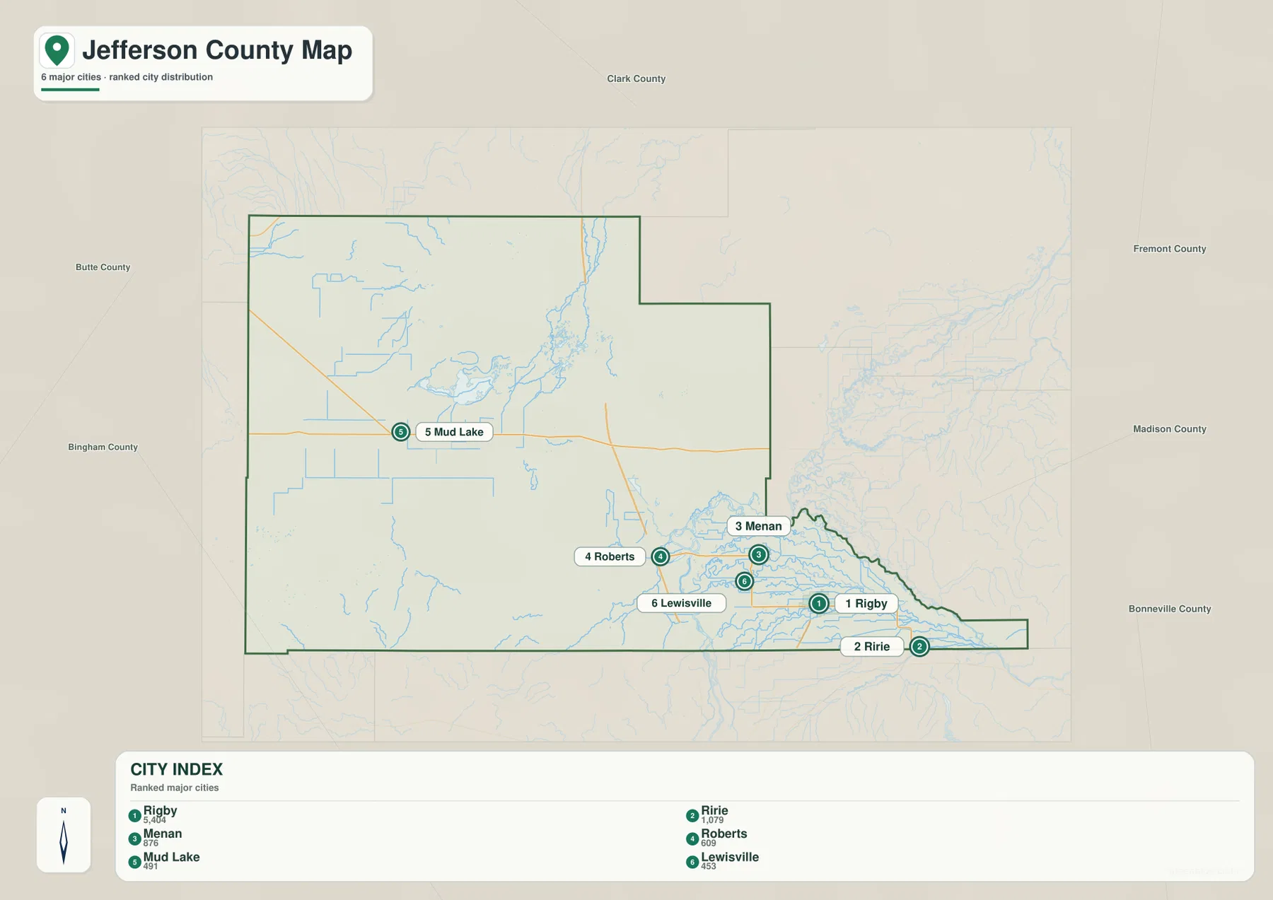
No mileage is printed between these communities on this city map. It should therefore not be treated as a driving-distance chart or as a straight-line distance table. Its purpose is simpler: Ririe is east of Rigby, Menan is northwest, Roberts is farther west, and Mud Lake lies much farther toward the west-central area. Use a current routing service when you need an actual road distance or travel time.
County labels around the edges provide useful geographic context without turning the section into a boundary list. Clark County is north of Jefferson County; Fremont and Madison counties are on the eastern side; Butte and Bingham counties lie to the west; and Bonneville County appears to the southeast. Together they show how Jefferson County fits among several jurisdictions in eastern Idaho.
Mud Lake waters in the northwest and Snake River canals in the southeast
The terrain-and-water map carries many more named water features than the general map. Mud Lake dominates the northwest, where Camas Creek and Beaver Creek approach the lake area and Sandhole Lake appears nearby. Jefferson Canal adds an artificial waterway to the same group, so the northwest is best understood as a combination of lake, creek, and canal features rather than as a single isolated body of water.
The southeast is much denser. The Snake River follows the southern side of the county, with Spring Creek and Dry Bed labeled nearby. Market Lake and Little Market Lake Canal appear in the same area, joined by Butte Market Lake Canal, Burgess Canal, and Harrison Canal. The mix matters because not every blue line represents a natural stream. Several are named canals, and readers should keep that distinction in mind when using the map.
Farther west, Owsley Canal and Second Owsley Canal extend across the central-western part of the county. These long artificial waterways help explain why the blue network can look complex even across broad, relatively subdued terrain. If you are searching for a named creek, lake, river, or canal, this map is more useful than the general county view because the hydrographic labels are given much greater emphasis.
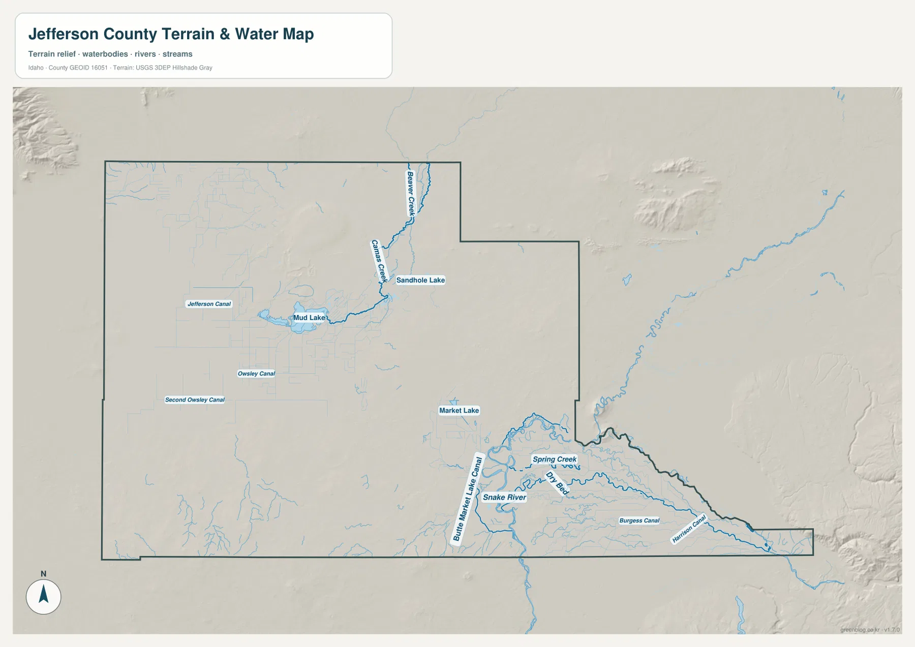
Jefferson County’s Parks & Recreation information provides local context for the Snake River by listing the Mike Walker Boat Ramp, along with Jefferson County Lake and campground information. Those facility details belong to current county guidance rather than to this reference map. The blue lines here should not be interpreted as flood zones, legal water-right boundaries, current flow conditions, or guaranteed navigation channels.
Broad lower ground broken by isolated higher terrain
The elevation map is dominated by lower green tones, which cover much of Jefferson County. Against that background, a rounded higher area stands out in the north-central portion, another elevated zone appears near the southwest edge, and smaller raised features show up toward the east and southeast. The county therefore looks broadly open and low in many places without being uniformly flat.
The legend deserves careful reading. The displayed color steps reach only about 1,574 meters, yet the printed summary below the map reports an actual elevation range from 1,445 to 2,033 meters and a mean of 1,484 meters. The upper color tick is not the county’s true maximum. It is simply part of the display scale, while the summary numbers describe the full range represented in the elevation data.
Comparing the elevation and water images is particularly useful around Mud Lake and the Snake River side of the county. Both areas are largely shown within the lower colors, while the isolated higher features rise elsewhere. That relationship helps explain the county at a broad scale, but it does not establish the exact elevation of a road, field, home, or other individual point.
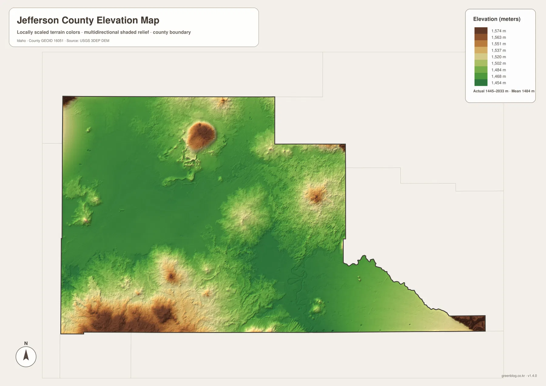
This is a generalized countywide elevation view, not a survey-grade engineering surface. Construction grades, drainage design, precise property elevations, and other point-specific work should be based on current source data such as the USGS 3D Elevation Program rather than measurements estimated from the rendered image.
Picking the map that answers your Jefferson County question
For a first look at Jefferson County, the general map is the best starting point because it combines the outline, roads, and familiar place names. The city distribution view is cleaner when you only need to compare Rigby with Ririe, Menan, Roberts, Lewisville, and Mud Lake. Readers interested in water should move to the terrain-and-water map, while the elevation image is designed for a broad comparison of lower and higher ground.
The WebP images embedded in the article are convenient for quick browser viewing, but the downloadable originals are better when small labels need to be enlarged or when the maps will be printed or used in presentation material. Each JPG is 3638×2572 pixels, and the ZIP includes the county map, city distribution map, terrain-and-water map, and elevation map as separate files.
U.S. Census Bureau QuickFacts lists 1,093.68 square miles of land area for Jefferson County in the 2020 geography data. Compressing an area of that size into a single image necessarily simplifies detail, so these maps work best as regional references. They are not substitutes for live navigation, parcel-level legal research, flood analysis, water-right determinations, or engineering elevation data.
Frequently Asked Questions
Can I use the city map to calculate the distance from Rigby to the other communities?
No. The city distribution map shows the relative positions of Rigby, Ririe, Menan, Roberts, Mud Lake, and Lewisville, but it does not print straight-line mileage or driving distances. Use it for direction and location; use a current routing service for actual road distance and travel time.
Which view shows both Mud Lake and the Snake River water network most clearly?
The terrain-and-water map is the most useful choice. It labels Camas Creek, Beaver Creek, Sandhole Lake, and Jefferson Canal around Mud Lake in the northwest, while the southeast includes the Snake River, Spring Creek, Market Lake, and several named canals.
Does the 1,574-meter legend mark the highest point in Jefferson County?
No. The color legend has an upper displayed step near 1,574 meters, but the printed elevation summary gives the full range as 1,445 to 2,033 meters with a mean of 1,484 meters. For a precise elevation at a specific point, use current USGS elevation data rather than estimating from this image.
Map File Information
Download the high-resolution Jefferson County JPG maps together in one ZIP when you need larger originals than the WebP previews on this page.
- Included Files: county map, city distribution map, terrain and water map, elevation map
- Printable Size: 3638×2572 pixels for each JPG
- File Type: ZIP containing 4 JPG images
Related Maps
Sources and references
For current county government and local information, see the official Jefferson County, Idaho website. The county’s Parks & Recreation page covers Jefferson County Lake, campground information, and the Mike Walker Boat Ramp on the Snake River. Current population and geography statistics are available through U.S. Census Bureau QuickFacts: Jefferson County, Idaho.
For the underlying geographic data types, consult U.S. Census Bureau TIGER/Line Shapefiles for boundaries and base geography, USGS National Hydrography for streams, lakes, and waterways, and the USGS 3D Elevation Program for elevation data.
Green Map creates custom-edited map images using open geographic data sources such as geoBoundaries, Natural Earth, OpenStreetMap, and government open data.
These maps are edited visual materials, not raw data files, and are provided for education, documents, presentations, and graphic reference.