Bonneville County Map files are available here as a ZIP of high-resolution A3 JPG maps, while the WEBP previews below make it easy to inspect the county in a browser first. The set follows the county from the Idaho Falls urban area east through Swan Valley and Irwin to Palisades Reservoir, with separate views for roads and places, major cities, waterways and terrain, and elevation.
Bonneville County has two very different geographic faces. The west is a broad, lower plain centered on Idaho Falls, Ammon, Iona, and Ucon. Farther east, the Snake River enters a narrow mountain corridor where Swan Valley and Irwin sit between higher ridges. The contrast is clear on every map, but it becomes especially striking when the water and elevation views are compared.
Table of Contents
A long county stretching east from Idaho Falls
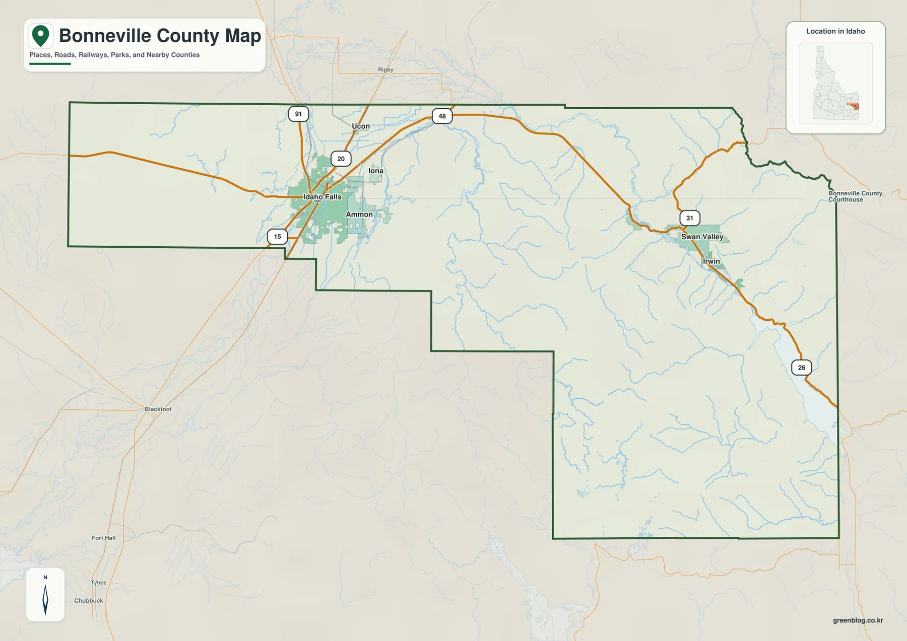
Idaho Falls anchors the western side of Bonneville County. Interstate 15, US 20, and US 91 all appear near the city, and State Highway 48 runs east from the Ucon area. Ammon lies immediately east of Idaho Falls, with Iona and Ucon farther north and northeast. This cluster gives the western end a much denser road and settlement pattern than the mountain country farther east.
The Idaho Blue Book records that Bonneville County was created in 1911 from northern and eastern parts of Bingham County and identifies Idaho Falls as the county seat. On the map, that history fits the modern settlement pattern: county government and the largest urban concentration are in the west, while the county boundary reaches a long distance eastward toward the Wyoming line.
The city pattern changes sharply between west and east
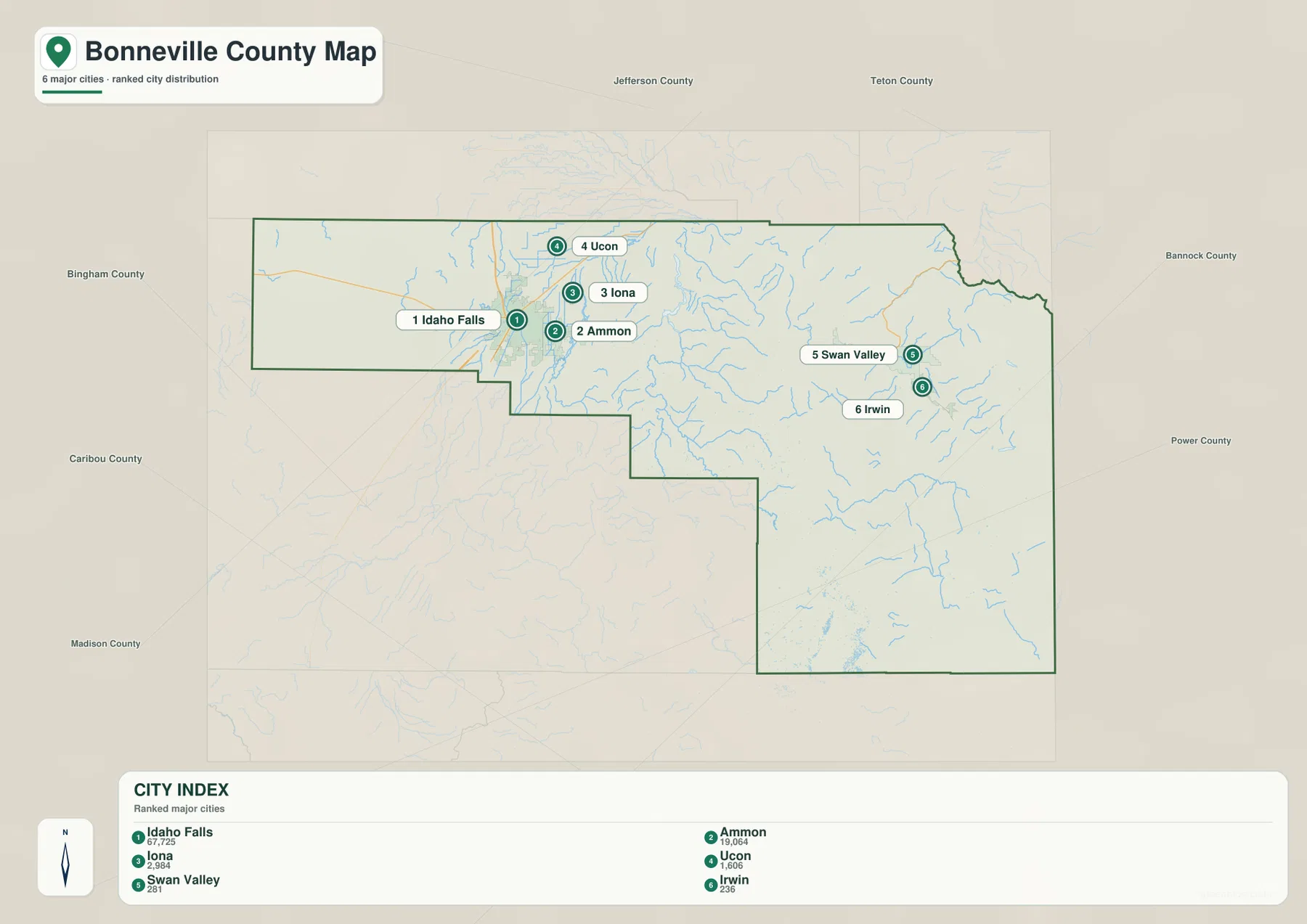
The city map highlights Idaho Falls, Ammon, Iona, Ucon, Swan Valley, and Irwin. Idaho Falls is the dominant city in the index, with Ammon immediately beside it. Iona and Ucon form smaller communities in the same western cluster, so four of the six marked places are concentrated in a relatively small part of the county.
Swan Valley and Irwin are different. They sit far to the east along the Snake River corridor and are separated from the Idaho Falls cluster by a wide stretch of foothills and mountain terrain. Finding those two places on the city map first makes the road map easier to read because US 26 follows the same general valley toward Palisades Reservoir.
Major roads follow both the plain and the Snake River corridor
Near Idaho Falls, I-15 provides the main north-south route and US 20 crosses the urban area. US 91 also follows the western corridor, while State Highway 48 runs east from the Ucon area. The concentration of roads reflects the flatter terrain and larger population center around Idaho Falls.
US 26 becomes the key route in the eastern half of the county. It follows the Snake River valley through Swan Valley and Irwin toward Palisades Reservoir. State Highway 31 branches northeast near Swan Valley, showing another mountain passage out of the river corridor. These roads are easier to understand when viewed together with the relief and elevation maps because the surrounding ridges sharply limit where a major route can run.
Snake River, Ririe Reservoir, and Palisades Reservoir shape the water map
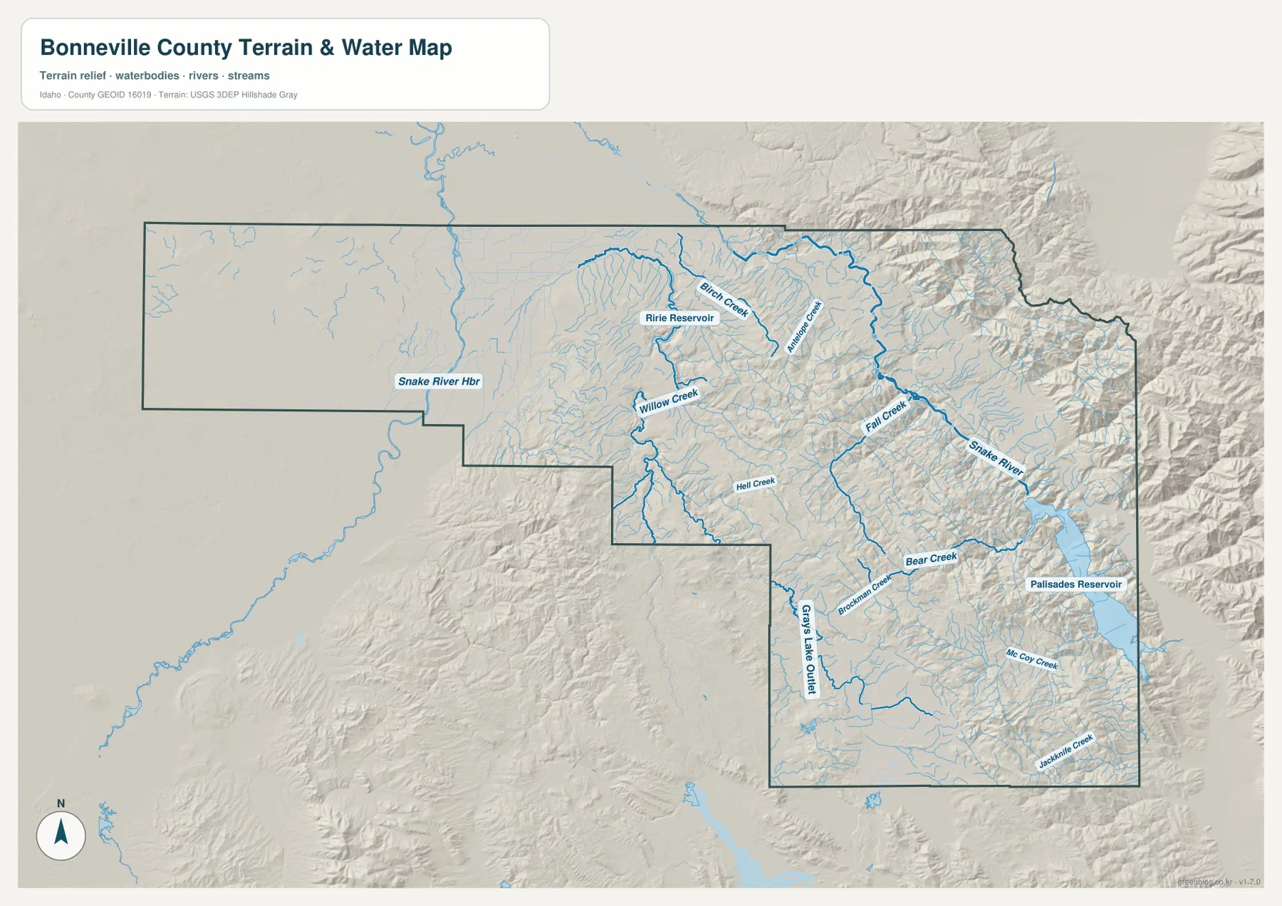
The Snake River is the main water feature connecting the eastern mountains with the Idaho Falls area. It leaves Palisades Reservoir, passes through the Irwin and Swan Valley corridor, and continues westward across the county. The valley floor remains lower than the ridges on either side, which is why the river and US 26 appear together through much of the eastern section.
Ririe Reservoir is labeled farther north, surrounded by tributaries such as Birch Creek and Antelope Creek. Willow Creek, Fall Creek, Bear Creek, and Brockman Creek are also named on the map, while McCoy Creek and Jackknife Creek appear in the southeast. The density of these smaller streams increases toward the rugged eastern and southern terrain.
Palisades Reservoir is the largest clearly labeled body of water in the eastern part of the map and provides a strong landmark for orienting the mountain corridor. This water-reference map is useful for locating rivers, reservoirs, and streams, but it is not a flood-hazard map, parcel map, depth chart, or navigation product.
Elevation rises dramatically toward the eastern mountains
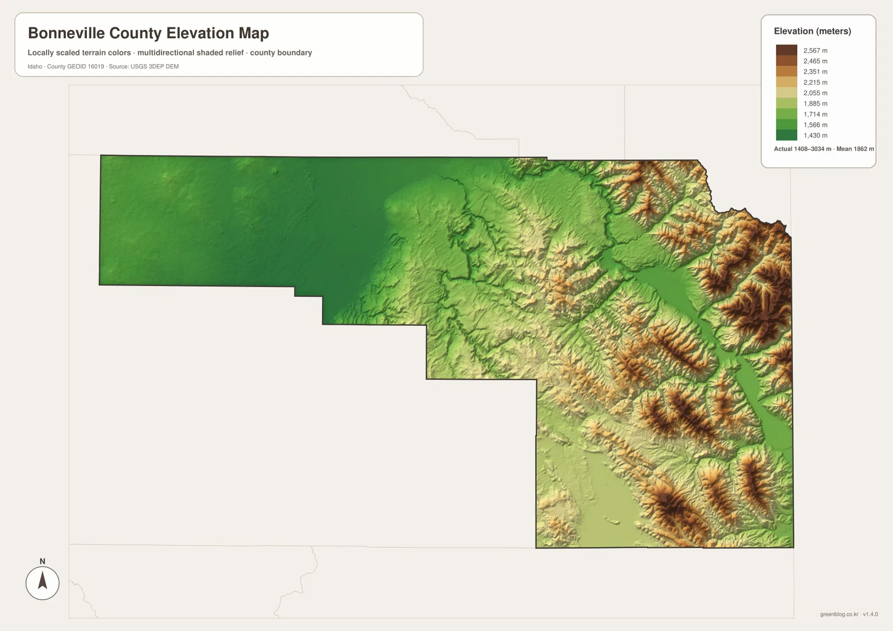
The elevation map shows the western plain in deep green, marking the lowest broad part of the county around Idaho Falls. Moving east, the colors shift through lighter green and yellow before reaching tan and brown in the higher mountain belts. The strongest relief appears along the eastern boundary and in the southeastern mountain blocks.
The map reports an actual elevation range of about 1,408 to 3,034 meters, with a mean near 1,862 meters. The Snake River and Palisades Reservoir occupy a lower corridor cut between much higher ridges. These values are useful for county-scale comparison, but the generalized surface should not be treated as survey-grade or engineering-grade elevation for a specific site.
Using the maps together gives a clearer county picture
For ordinary orientation, begin with the county overview and city map. They show how Idaho Falls, Ammon, Iona, and Ucon relate to the main highways and how far Swan Valley and Irwin sit from the western urban area. For a trip east on US 26, pairing the road map with the water map makes the Snake River corridor easy to follow.
The elevation view adds the final piece. Idaho Falls lies on the broad lower plain, while the eastern communities occupy a much narrower valley surrounded by high terrain. In a classroom, report, or regional comparison, the same place can be traced across all four views to show how settlement, roads, water, and relief fit together.
Frequently Asked Questions
What is the main city in Bonneville County?
Idaho Falls is the largest city shown on the map and the county seat. It is the main reference point for the western road network, with Ammon, Iona, and Ucon close by.
Where is Palisades Reservoir on the map?
It is near the eastern end of Bonneville County along the Snake River corridor. From Swan Valley and Irwin, US 26 continues southeast toward the reservoir through a narrow valley surrounded by high mountains.
What is the best use for the elevation map?
It is best for comparing the low western plain with the high eastern mountains and for seeing how the Snake River valley cuts through the relief. It is a regional reference map rather than a substitute for site-specific survey measurements.
Map File Information
The ZIP contains high-resolution A3 JPG versions of the Bonneville County overview, city, terrain-and-water, and elevation maps.
- File Type: JPG files inside one ZIP archive
Related Maps
Sources and references
- Bonneville County official website
- Idaho Secretary of State — Idaho Blue Book
- U.S. Census Bureau TIGER/Line Shapefiles
- USGS National Hydrography
- USGS 3D Elevation Program
Green Map creates custom-edited map images using open geographic data sources such as geoBoundaries, Natural Earth, OpenStreetMap, and government open data.
These maps are edited visual materials, not raw data files, and are provided for education, documents, presentations, and graphic reference.