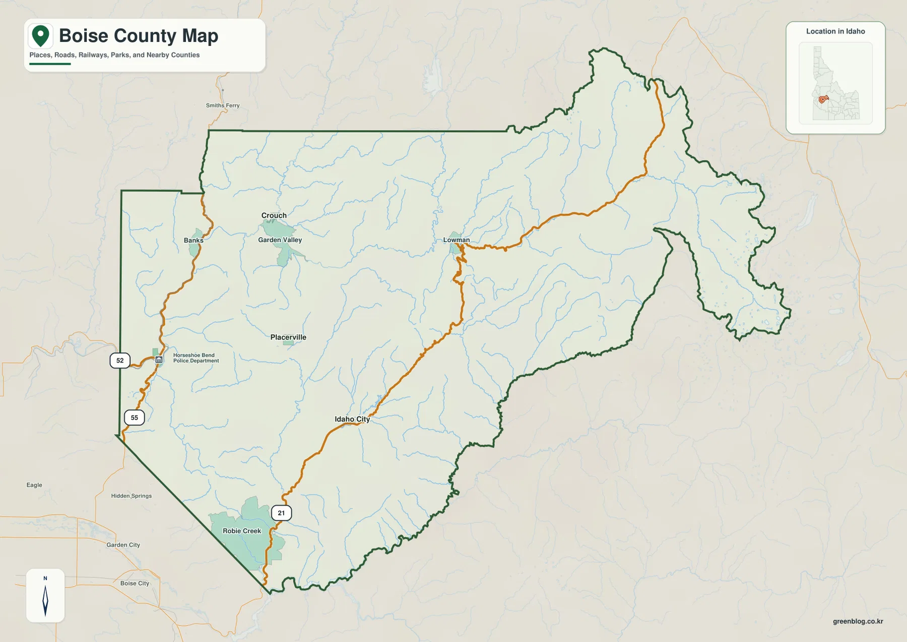
Boise County Map files are available here as a ZIP of high-resolution A3 JPG maps, with WEBP previews for quick viewing on the page. The set is useful for locating Idaho City, Horseshoe Bend, Garden Valley, Crouch, Lowman, and the main roads, then comparing those places with the Payette River forks, mountain streams, lakes, and the county’s large elevation range.
The overview immediately separates Boise County from nearby Boise City. Boise City is labeled outside the county boundary to the southwest, while the county itself stretches through rugged mountain country from the lower western valleys to much higher terrain in the northeast. Idaho City anchors the southern interior, Horseshoe Bend sits on the western edge, and the Garden Valley–Crouch area occupies a separate mountain valley farther north.
Table of Contents
A county shaped by valleys rather than a single urban center
Boise County has an irregular outline with a narrow western section, a broad mountainous middle, and a long northeastern reach. Idaho City appears south of center, Horseshoe Bend is near the western boundary, and Placerville lies between the western communities and Idaho City. Garden Valley and Crouch are farther north, while Lowman sits east of them along a road corridor that continues into higher country.
State Highway 21 enters from the southwest, passes Idaho City, and continues toward Lowman. Highway 55 follows the western side near Horseshoe Bend. Because these roads follow mountain valleys, the county does not read like a flat grid: a place that looks close on the page may require a much longer drive around ridges and through river corridors.
The surrounding labels also help with orientation. Ada County and the Boise metropolitan area are to the southwest, Gem County is west, Valley County is north, and Custer, Camas, Blaine, and Elmore counties frame the eastern and southern sides. That context is useful for readers who know the city of Boise but are less familiar with the mountain county that shares its name.
Horseshoe Bend works as the hub on the city-connections map
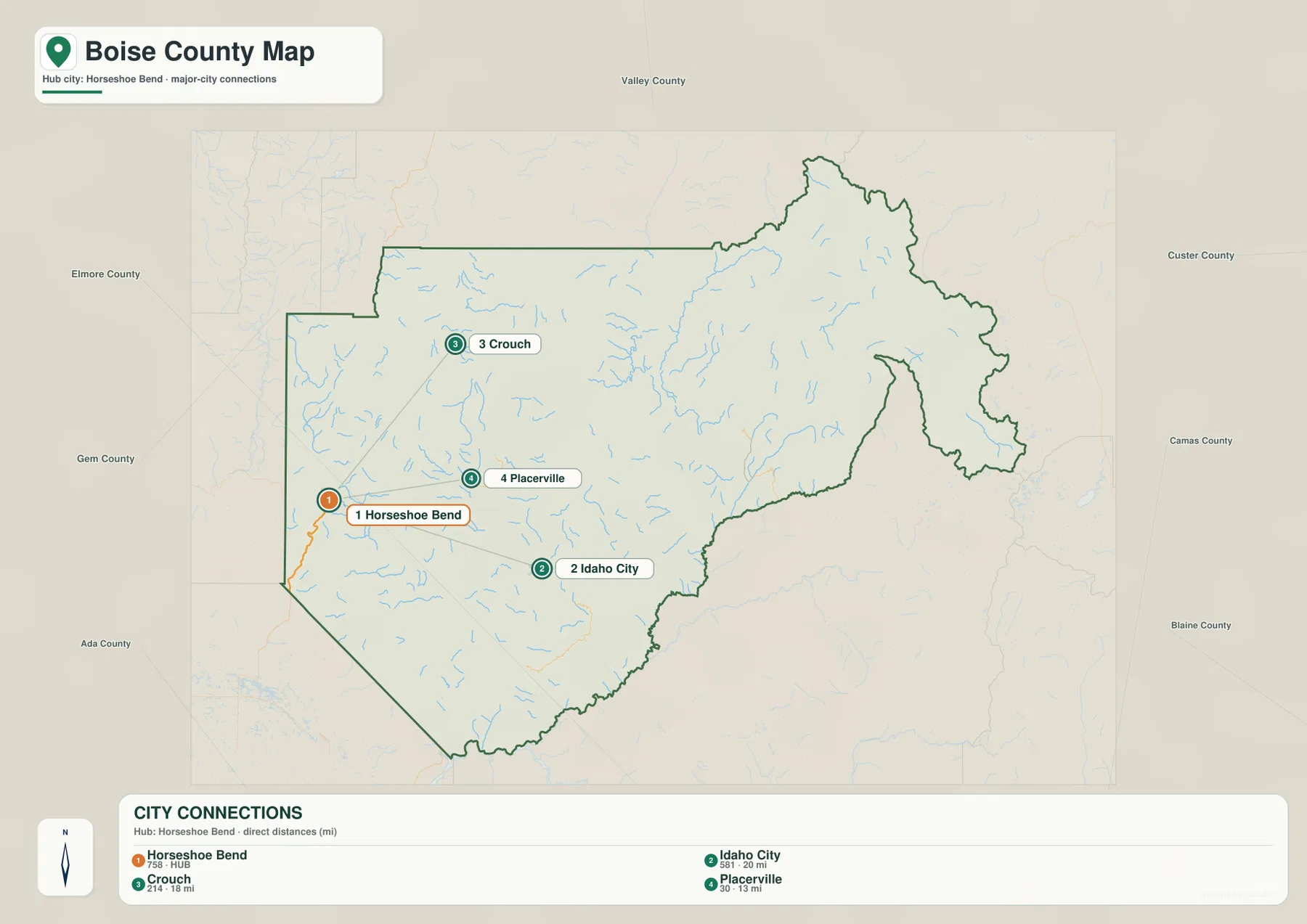
The city map simplifies the county to four labeled places and uses Horseshoe Bend as the hub. Idaho City is shown about 20 miles away, Crouch about 18 miles, and Placerville about 13 miles. Those figures are straight-line distances, not driving distances, so they are best used for comparing direction and relative spacing rather than estimating travel time.
The arrangement is more informative than the numbers alone. Placerville is east of Horseshoe Bend, Crouch is farther north, and Idaho City is southeast of the hub. When the city map is compared with the overview, Garden Valley and Lowman fill in the broader mountain corridor between the western Payette drainage and the interior high country.
This stripped-down view is especially helpful when a reader needs to explain where the main communities sit without the visual clutter of every road and stream. For actual driving, however, the overview map or a current road-navigation source is more appropriate because the county’s winding mountain routes are not represented by the straight connector lines.
The Payette forks dominate the west while Boise River headwaters cut the east
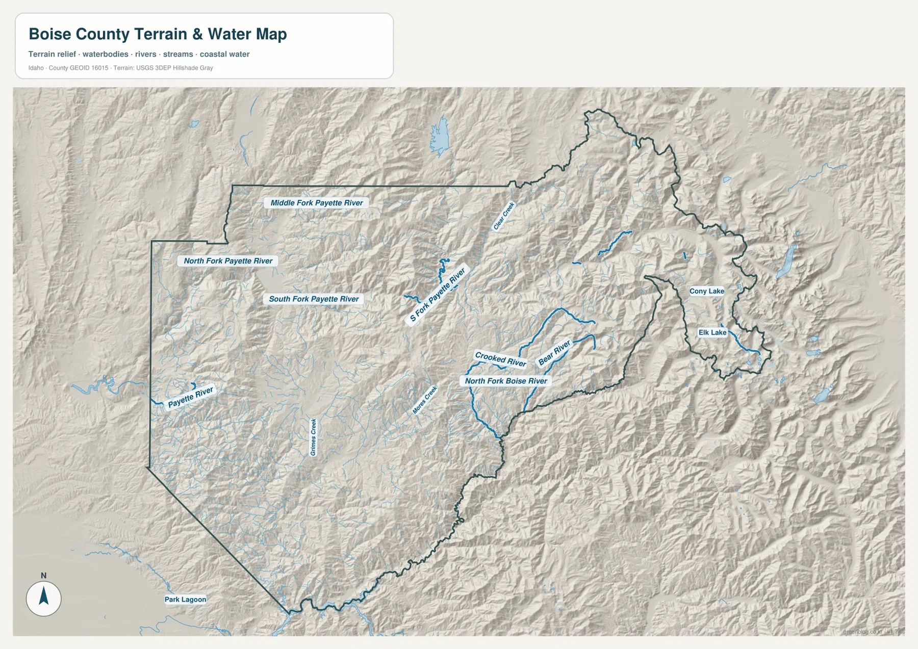
The terrain-and-water map shows why Boise County is difficult to summarize with one river. Along the western side, the Payette River and North Fork Payette River appear close to the county edge. Farther into the mountains, the South Fork Payette River and Middle Fork Payette River spread through separate valleys, creating the water framework around the Garden Valley and Crouch area.
East of the central divide, the drainage changes. North Fork Boise River runs through the eastern interior, joined by mountain streams such as Crooked River, Bear River, Mores Creek, Clear Creek, and Grimes Creek in different parts of the county. The map makes it easier to see that Boise County straddles several steep watersheds rather than one continuous valley.
Cony Lake and Elk Lake are labeled in the far eastern high country. Their setting is noticeably rougher than the western river valleys, with tightly packed ridges and short tributaries around them. This map is a reference for terrain, rivers, streams, and lakes; it is not a flood map, parcel map, or navigation chart and should not be used as one.
Elevation rises sharply from the western valleys to the northeast
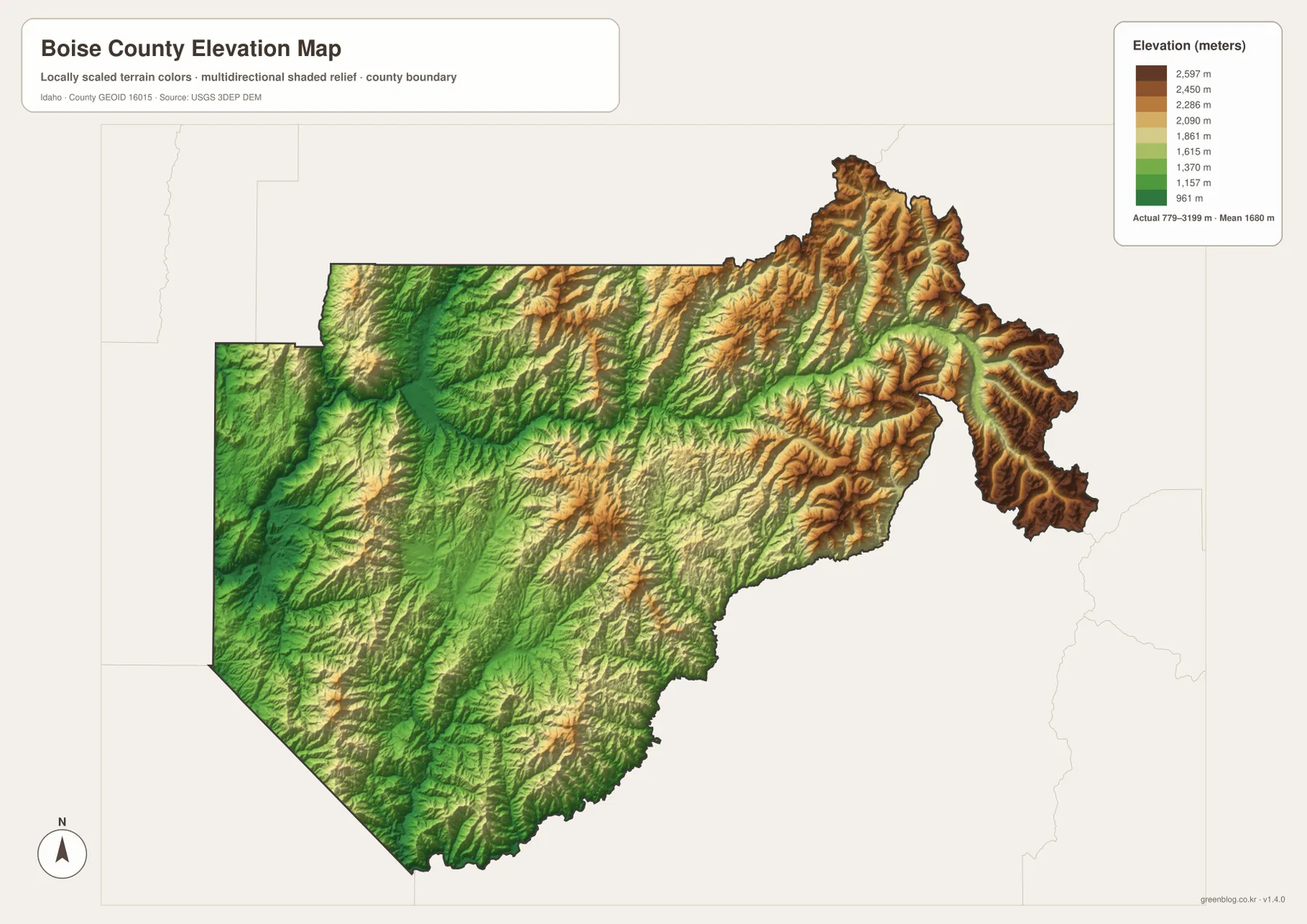
The elevation map is one of the clearest ways to understand the county. Lower green terrain is concentrated in the west and southwest valleys, while yellow, tan, and brown ridges become much more common toward the center, north, and especially the northeastern and eastern boundaries. The county is mountainous almost everywhere, but the height difference between the valley floors and the high ridges is substantial.
The map reports an actual elevation range of about 779 to 3,199 meters and a mean near 1,680 meters. That range explains the contrast between the Horseshoe Bend side of the county and the high terrain beyond Lowman or around the eastern lakes. The colored surface is intended for county-scale comparison; it is not a survey-grade measurement for a road, parcel, building site, or engineering project.
Comparing this map with the road map also clarifies why Highway 21 bends through a chain of lower corridors instead of cutting straight across the county. Idaho City and Lowman are separated by ridges, and the northeastern extension contains some of the darkest high-elevation colors on the page. The western side is lower overall, but it is still broken by steep local relief rather than broad level plains.
Boise Basin history still appears in the place names
Idaho City, Placerville, and Grimes Creek are more than reference labels on the map. Boise County’s official history page describes the 1862 gold rush to the Boise Basin as a major event in the development of the region, and the county was established on February 4, 1864. Idaho City became the county seat and remains the location of the county courthouse and offices.
The maps help place that history in its physical setting. Placerville lies northwest of Idaho City, and Grimes Creek runs through mountain terrain to the southwest. These communities and streams are surrounded by ridges rather than broad lowlands, which gives useful geographic context to the early mining settlements described by the county.
Choose the map by the question you are trying to answer
For general orientation, the county overview is the best starting point because it combines communities, roads, nearby counties, and the boundary. The city-connections map is better when the main question is how Horseshoe Bend, Idaho City, Crouch, and Placerville relate to one another. Water and terrain become much easier to follow on the dedicated hydrography view, while the elevation map is the fastest way to compare lower valleys with the high northeast.
The maps also work well in sequence. A reader can locate Idaho City on the overview, find nearby Grimes Creek and Mores Creek on the water map, and then compare the surrounding ridges on the elevation map. The same method works for Horseshoe Bend and the western Payette drainage, or for Lowman and the higher terrain toward the county’s northeastern extension.
Frequently Asked Questions
Is Boise City inside Boise County?
No. On the county overview, Boise City is labeled outside the Boise County boundary to the southwest. Idaho City is the county seat, while Horseshoe Bend, Garden Valley, Crouch, Placerville, and Lowman are among the other useful reference points shown within the county.
Do the city-connection distances represent road mileage?
No. The city map uses straight-line distances from Horseshoe Bend to Idaho City, Crouch, and Placerville. Mountain roads curve through valleys and passes, so actual driving mileage and travel time can be substantially different.
What is the most useful map for Boise County’s mountain relief?
The elevation map gives the fastest county-wide comparison, showing an actual range of about 779 to 3,199 meters. The terrain-and-water map adds the river valleys and ridges, so the two maps together are the best choice when the goal is to understand how water and elevation shape the county.
Map File Information
The ZIP contains high-resolution A3 JPG versions of the Boise County overview, city-connections, terrain-and-water, and elevation maps. Use these files when the on-page WEBP previews are too small for printing or presentation work.
- Included Files: county overview, city-connections map, terrain and water map, elevation map
- File Type: JPG files in one ZIP archive
Related Maps
Sources and references
- Boise County official site — Visit Boise County and Boise Basin history
- U.S. Census Bureau TIGER/Line Shapefiles
- USGS National Hydrography
- USGS 3D Elevation Program
Green Map creates custom-edited map images using open geographic data sources such as geoBoundaries, Natural Earth, OpenStreetMap, and government open data.
These maps are edited visual materials, not raw data files, and are provided for education, documents, presentations, and graphic reference.