You can download four high-resolution JPG maps of Roberts County in one ZIP file from this page. The maps use Sisseton as the main central reference, place Rosholt, Peever, Wilmot, Summit, and other towns around it, and show the Little Minnesota River, Jorgenson River, North Fork Whetstone River, lakes, and a strong elevation change from the western edge into the central and eastern lowlands. The four layers are most useful when the same places are followed from roads to waterways and then to relief.
Sisseton lies slightly west of the county center and is easy to find on the general map. Claire City and Rosholt are to the north, Peever and Wilmot extend southward, and Summit sits near the narrow southwestern end of the county. The eastern edge follows a broad curving water boundary rather than a simple straight county line. Roads 117, 7, and 109 run close to that side, while Long Hollow and Agency Village provide additional reference points near Sisseton.
The water and elevation maps reveal the county’s strongest physical contrast. Little Minnesota River comes down from the northwest, Jorgenson River continues through the central-southern interior, and North Fork Whetstone River forms a long southeastern drainage. The elevation legend reports an “Actual” range of about 294 to 645 meters with a mean near 405 meters. High brown terrain is concentrated along the west, while the center and east are much greener and lower.
Table of Contents
Follow Sisseton north toward Rosholt and south toward Wilmot
The general county map is easiest to read from Sisseton. North of the city, the road network reaches Claire City and then continues east toward Rosholt. Roads 25, 106, and 127 provide strong east-west references across the upper part of the county. Farther east, White Rock Colony appears near the curving water boundary. The north contains a mix of long straight roads, small lakes, and short tributaries, so road orientation is more useful when the blue drainage lines are kept in view.
South of Sisseton, Peever and Wilmot lie along the long central corridor. Road 81 is marked near Wilmot, and road 123 extends south from that area. Summit is farther south near the narrow southwestern end of the county. Ortley and Corona appear outside the county boundary and help show where the mapped county ends. These road labels are static location references rather than live traffic information, so construction, closures, and travel time require a current transportation source.
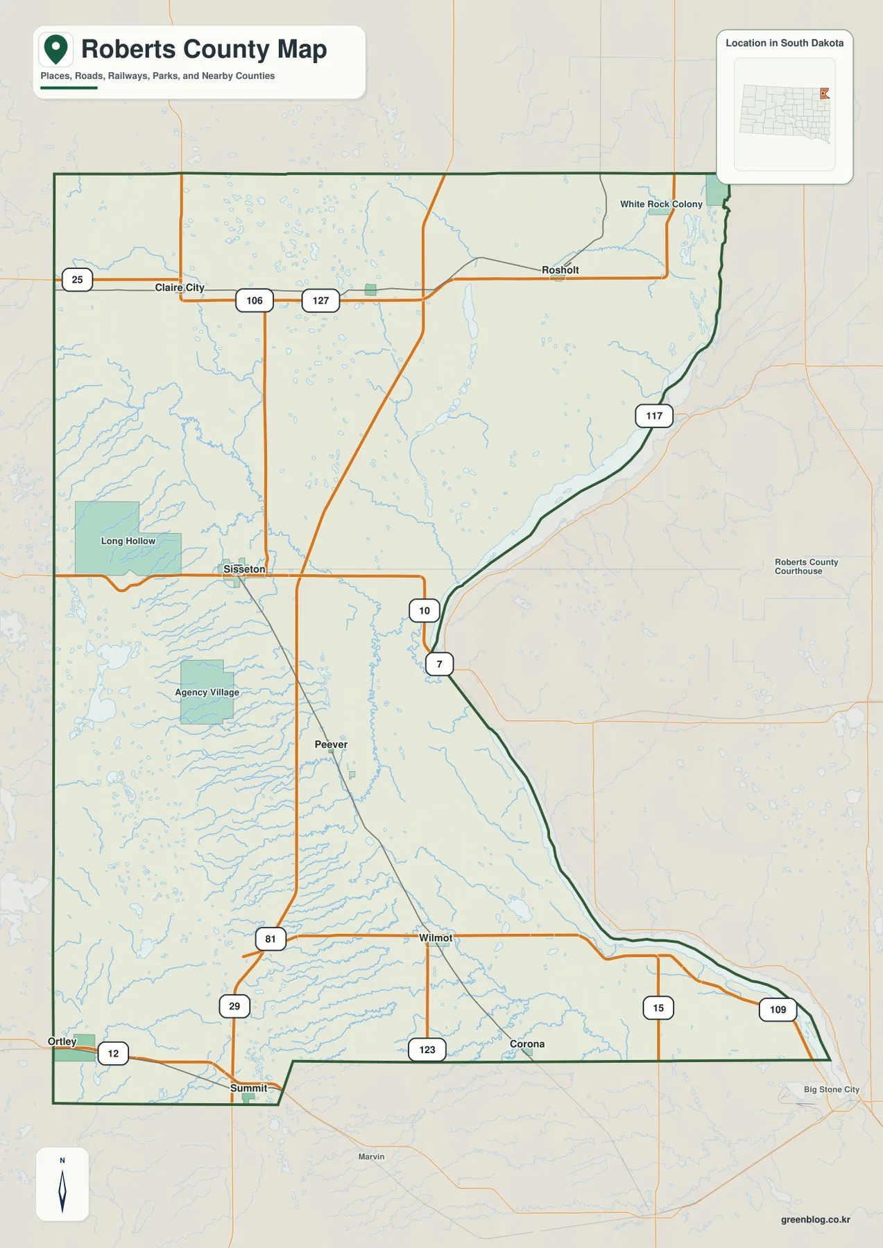
The road map also hints at the terrain change. The west contains dense blue tributaries descending from higher ground, while the eastern side is dominated by a broad low water margin and fewer steep-looking contours. The difference becomes much clearer on the terrain-and-water and elevation maps, which connect the drainage pattern to the county’s sharp west-to-east drop in relief.
Six ranked towns extend from New Effington and Rosholt to Summit
The city-distribution map highlights Sisseton, Rosholt, Wilmot, Summit, New Effington, and Peever. Sisseton remains the central-western anchor, while Rosholt and New Effington occupy the northern half. Peever sits south of Sisseton, and Wilmot and Summit continue farther down the county. The result is a long north-south distribution rather than one compact cluster of towns.
No connector lines or mileage labels appear on this city map. The gaps between the markers should therefore be read as relative position, not as measured straight-line or driving distance. The CITY INDEX numbers identify the selected cities and do not represent mileage, elevation, travel sequence, or population rank for route planning. Use a dedicated distance or routing source when an actual measurement is needed.
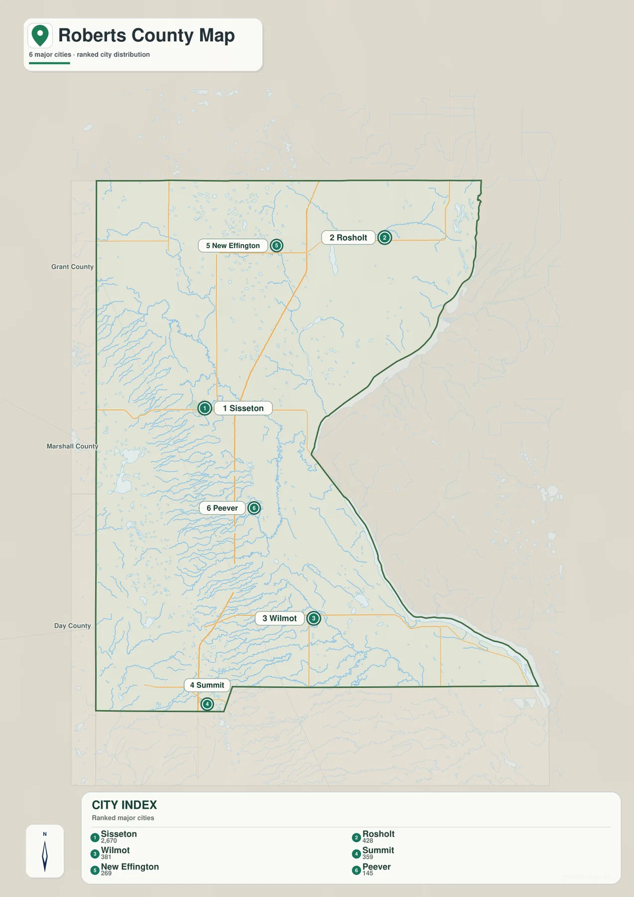
The city layer and the general map serve different purposes. The general map includes roads, colonies, neighboring places, and drainage lines, while the city layer simplifies the county to its six ranked city markers. Finding Sisseton on both maps and then comparing Rosholt in the north with Wilmot in the south gives a quick sense of how the settlement pattern stretches through the county.
Little Minnesota River, Jorgenson River, and Whetstone drainage divide the county
Little Minnesota River is the most prominent named drainage in the northwest. It enters from the western side, bends through the upper-central county, and gathers many short tributaries descending from the higher western terrain. Cottonwood Lake lies in the north-central interior, while Clubhouse Lake and Big Slough provide water references near the northeast. These features give the northern half a mix of river, wetland, and lake geography.
Farther south, Jorgenson River becomes a strong central reference. Lake Whipple and Oneroad Lake lie to the west, while Big Coulee Creek approaches from the southwest and passes near Mud Lake. Owl Lake and Hurricane Lake are farther south. In the southeast, North Fork Whetstone River follows a long diagonal valley with Bullhead Lake nearby. These different directions make the southern drainage much more varied than a single north-south river system.
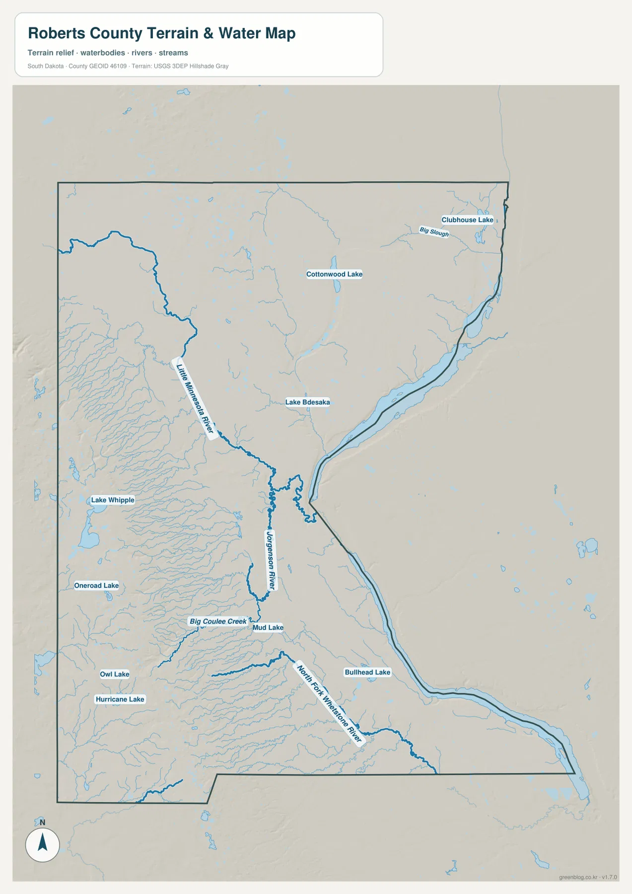
This water layer is a geographic reference for stream and lake names and locations. It does not show real-time flow, water depth, water quality, flood zones, or navigability, and a blue line should not be treated as a property or legal boundary. For current hydrographic source data, consult an authoritative dataset such as USGS National Hydrography.
The elevation legend spans about 294–645 m from the western rise to eastern lowlands
The elevation map’s “Actual” line reports about 294 to 645 meters with a mean near 405 meters. The western edge contains broad brown and tan terrain that rises well above the rest of the county. Moving east from that zone, the colors change rapidly through yellow-green into broad green lowlands around Sisseton and the central interior. The far eastern water margin and major drainage corridors are among the lowest continuous areas on the map.
The high western terrain is dissected rather than flat. Numerous short tributaries cut green and light-green grooves through the slopes before joining larger channels such as Little Minnesota River and Big Coulee Creek. Jorgenson River and the eastern water margin occupy lower terrain farther east. Comparing the water and elevation layers makes the relationship clear: the largest drainage corridors generally follow the lowest parts of the county.
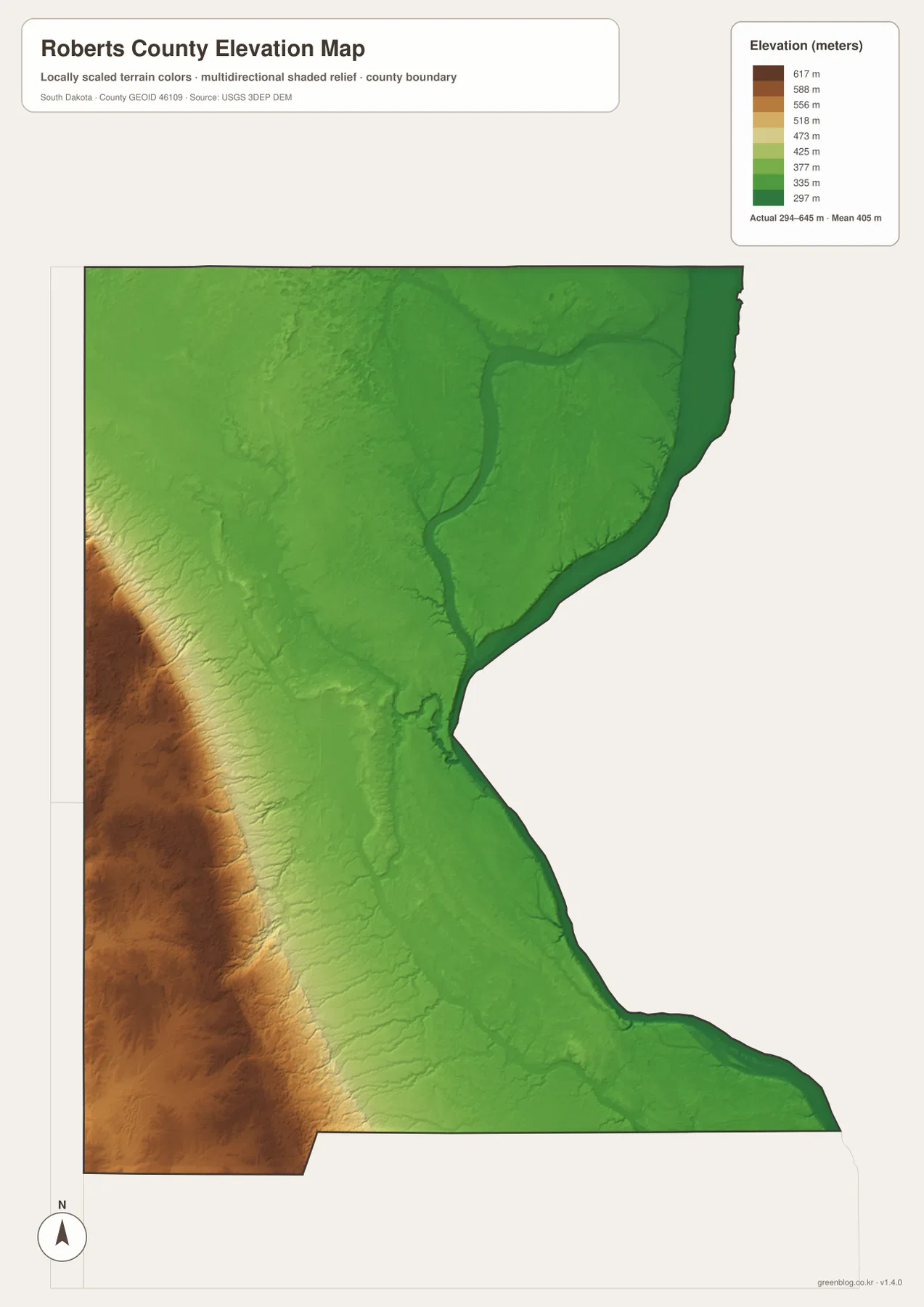
The elevation colors are designed for broad county-scale comparison rather than site measurement. They cannot provide a survey-grade elevation for a road point, building site, field corner, or engineering location. When a precise value is required, use official DEM products such as the USGS 3D Elevation Program or an appropriate survey.
Compare Sisseton and Lake Whipple to connect settlement, drainage, and relief
Sisseton is the best road and settlement reference, while Lake Whipple provides a useful western water reference. Around Sisseton, the elevation surface is already part of the broad central lowland. Moving west toward Lake Whipple reaches much steeper terrain where numerous short tributaries descend from the high western side. Checking those two locations on the water and elevation maps makes the rapid transition in relief easier to understand.
Rosholt and Wilmot provide another north-south comparison. Rosholt lies closer to the northeastern water margin and the northern lake country, while Wilmot and Summit are nearer the southern drainage associated with North Fork Whetstone River and smaller tributaries. Following these same town names across the maps connects roads, settlement, water, and elevation without turning the county description into separate lists.
The WebP images in the article are optimized for screen viewing. The download archive contains the original JPG files for the general county map, city-distribution map, terrain-and-water map, and elevation map. Each JPG is 2572 × 3638 pixels, making the originals more suitable for A3 printing, presentations, classroom materials, and closer inspection of labels.
Frequently Asked Questions
Does the city map give the distance from Sisseton to Rosholt or Wilmot?
No. The city-distribution map shows six ranked cities but includes no connector lines or mileage labels. Use a separate distance or routing source when an actual straight-line or driving distance is required.
Which map best shows Little Minnesota River and North Fork Whetstone River?
The terrain-and-water map is the clearest choice. Little Minnesota River crosses the northwest and central area, while North Fork Whetstone River forms a long southeastern valley. Jorgenson River and Big Coulee Creek are also labeled.
Can the map-legend range of about 294–645 m be used as an exact property elevation?
No. Those values are the county-wide “Actual” range printed on the supplied elevation map, while the colored surface is intended for broad terrain comparison. Use official DEM or survey data when an exact elevation is required at a specific location.
Map File Information
The ZIP contains the original high-resolution JPG files for the Roberts County general map, city-distribution map, terrain and water map, and elevation map.
- Included Files: 4 JPG maps
- Printable Size: 2572 × 3638 px each
Related Maps
Sources and references
- U.S. Census Bureau TIGER/Line Shapefiles – official geographic source for county boundaries and base mapping data.
- USGS National Hydrography – official source for rivers, streams, lakes, and hydrographic data.
- USGS 3D Elevation Program – official source for elevation and DEM products.
Green Map creates custom-edited map images using open geographic data sources such as geoBoundaries, Natural Earth, OpenStreetMap, and government open data.
These maps are edited visual materials, not raw data files, and are provided for education, documents, presentations, and graphic reference.