You can download four high-resolution JPG maps of Meade County in one ZIP file from this page. The county stretches from the Sturgis area in the southwest to Faith near the northeastern edge, and the supplied maps make that long cross-county contrast easy to see. The article follows the main roads and settlement positions first, then uses the Sturgis-centered city map, the Sulphur Creek and Cheyenne River water network, and the elevation layer to show how sharply the county changes from high western terrain to lower country farther east.
The county outline is unusually useful for orientation. A large rectangular block occupies the northeast, while the western and southwestern sides step inward and outward around the Sturgis, Piedmont, and Summerset area. Road 212 runs across the northern edge, 73 follows the east side, and several labels cluster in the southwest, including 34, 79, 14, and 90. That concentration of roads and places contrasts strongly with the much broader interior to the north and east.
Water is distributed throughout the county rather than confined to one corner. Sulphur Creek crosses the northern interior, Elm Creek drops south through the middle, and the Cheyenne River occupies a pronounced southeastern valley. Elk Creek follows a long route across the south, while Alkali Creek and Spring Creek appear near the higher western side. Named lakes range from Bear Butte Lake in the southwest to Maurine, Vansickel, Opal, and Durkee lakes in the north.
The elevation map adds the strongest visual contrast. Its legend reports an actual range of about 576 to 1,661 meters, with a mean near 841 meters. The highest colors collect in the west and southwest, while large areas of the north and east appear in lower green tones. With more than a thousand meters between the reported minimum and maximum, relief is not a minor background detail here; it is one of the defining features visible across the four maps.
Table of Contents
Road labels crowd together near Sturgis and spread out across the northeast
For the general map, the southwest is the best place to begin. The 34 and 79 labels sit close to the western side, with 14 and 90 farther south. Piedmont and Summerset are near the southern boundary, and Box Elder appears farther east. A Fort Meade VA Medical Center marker provides another recognizable reference near the western road cluster. Once this compact area is located, the scale of the rest of the county becomes much easier to judge.
Moving east and north produces a different map. Road 34 extends into the interior, while 73 runs along the eastern side and 212 occupies a long northern stretch. Settlements and road shields become less concentrated, and the blue stream network becomes more prominent. The map is useful for relative position and county-scale route orientation, but it is not a live road-condition layer and should not be used for current closures, construction, or travel-time decisions.
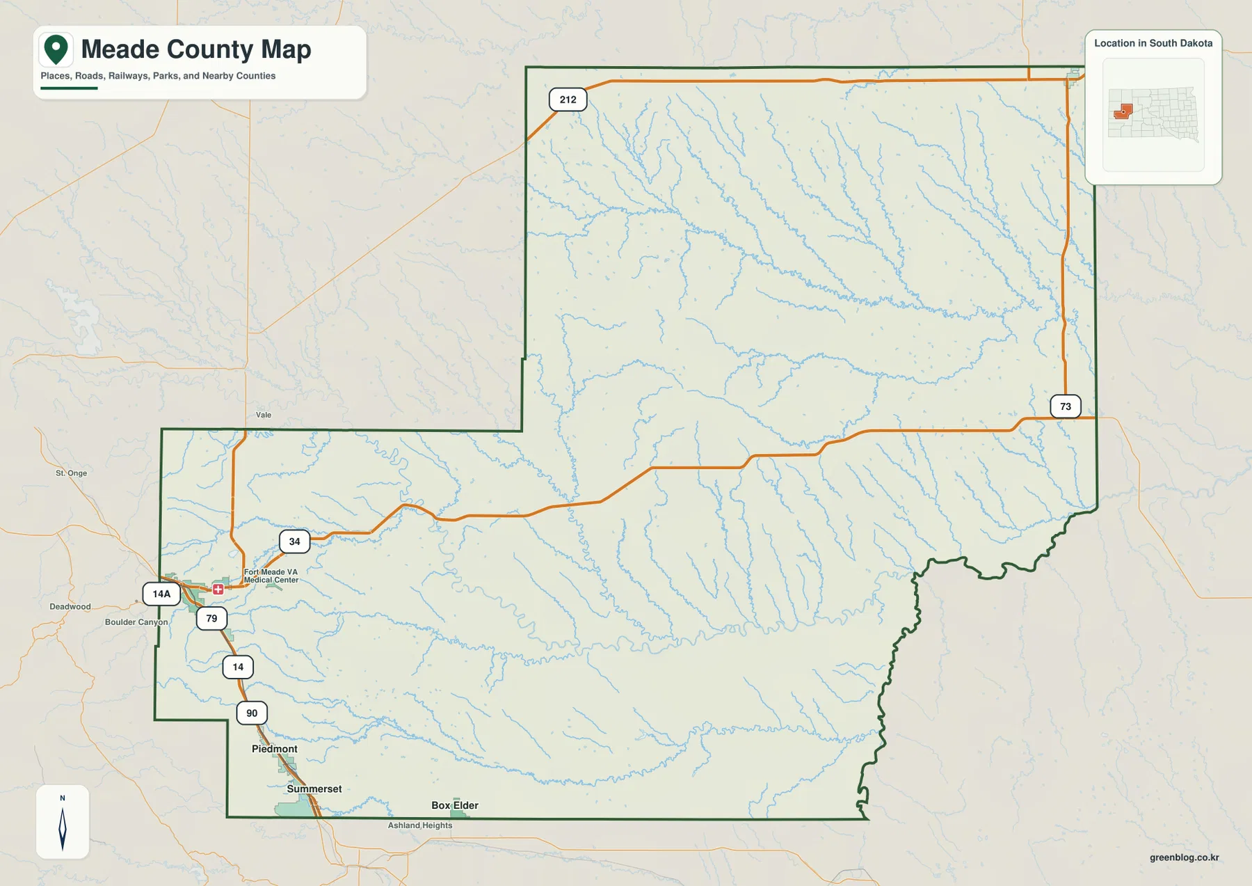
The boundary itself becomes a locator when the map types are compared. The northeast is broad and rectangular, the west-central edge makes a large inward step, and the southern portion extends back toward the Piedmont-Summerset area. The southeast boundary bends more irregularly around river-cut terrain. Recognizing those shapes makes it much easier to match the same part of Meade County on the city, water, and elevation maps.
Faith is 85 straight-line miles from Sturgis, far beyond the two southern connections
The city-connections map identifies Sturgis as the hub and places three comparison cities around it. Piedmont is southeast of Sturgis, Summerset lies nearby on the southern side, and Faith is isolated near the far northeast. The CITY CONNECTIONS legend lists about 15 miles from Sturgis to Piedmont, 19 miles to Summerset, and 85 miles to Faith.
Those figures are direct straight-line distances rather than driving mileage. The 85-mile Faith value is especially useful for understanding the county’s large southwest-to-northeast span, but a road trip between the same places will follow a longer route. The 15- and 19-mile values for Piedmont and Summerset are measured the same way, so they should also be treated as geographic comparisons rather than route-planning numbers.
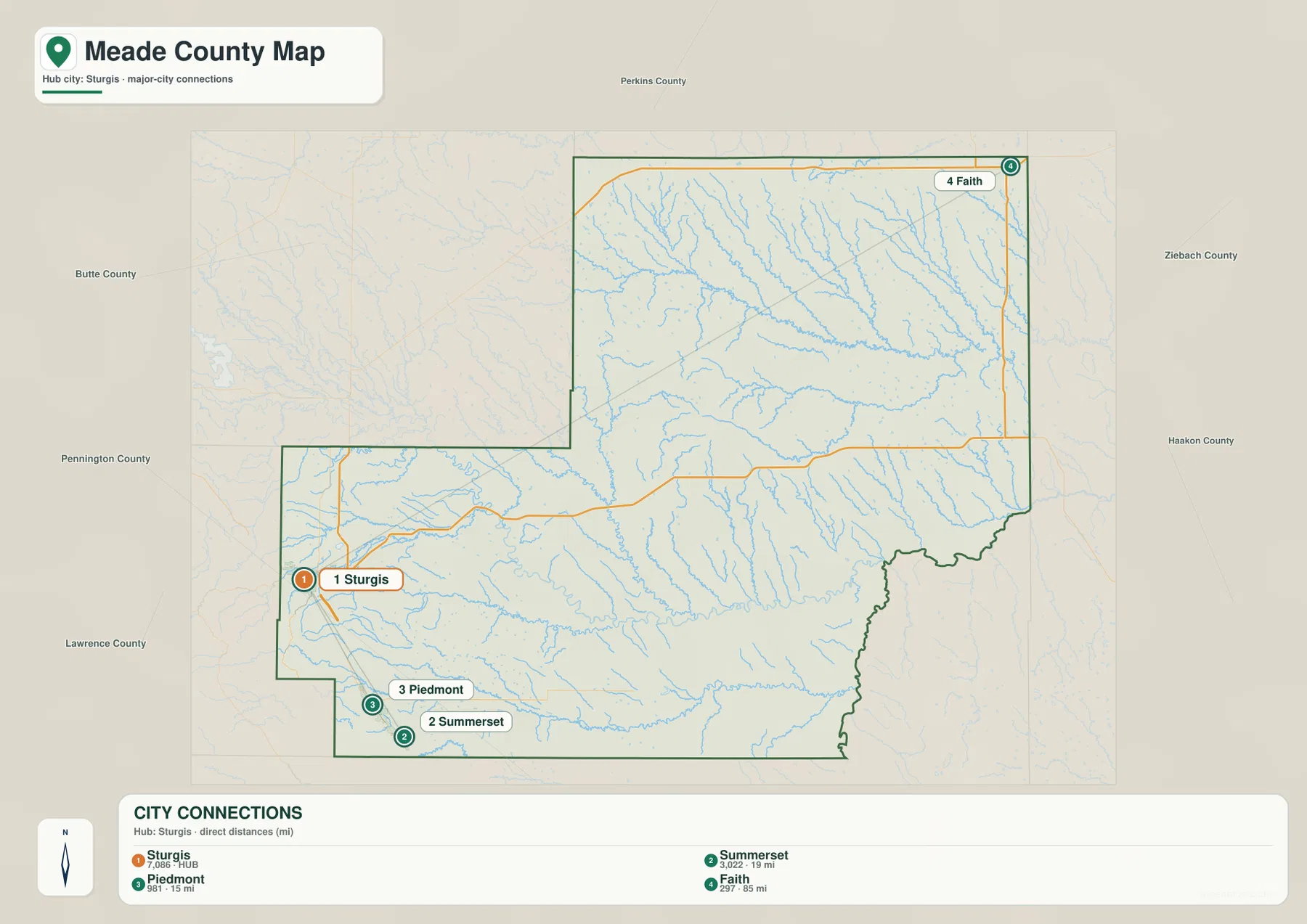
The same map labels surrounding counties, which helps place Meade County within western South Dakota. Perkins County is shown to the north, Butte County to the west, Ziebach County to the east, and Haakon County to the southeast. Pennington and Lawrence counties appear along the southwest side. These labels are useful geographic references, not parcel or legal-boundary documentation.
Sulphur Creek dominates the north while Elk Creek and the Cheyenne River shape the south
Sulphur Creek is the most prominent named watercourse in the northern part of the terrain-and-water map. It enters from the west and follows a long eastward route through the upper interior, receiving many small tributaries along the way. North of it are Maurine Lake, Vansickel Lake, and Opal Lake, with Durkee Lake farther northeast. Wilson Lake provides a separate eastern reference closer to the middle of the county.
The southern half has a different set of long drainage lines. Elm Creek drops through the center, the Cheyenne River occupies the southeast, and Elk Creek traces a long route near the southern edge. Alkali Creek crosses the southwest, while Spring Creek and Bear Butte Lake sit near the high western margin. Tisdale Lake appears farther east along the southern interior. Together these names show that Meade County contains several distinct drainage areas rather than one dominant river corridor.
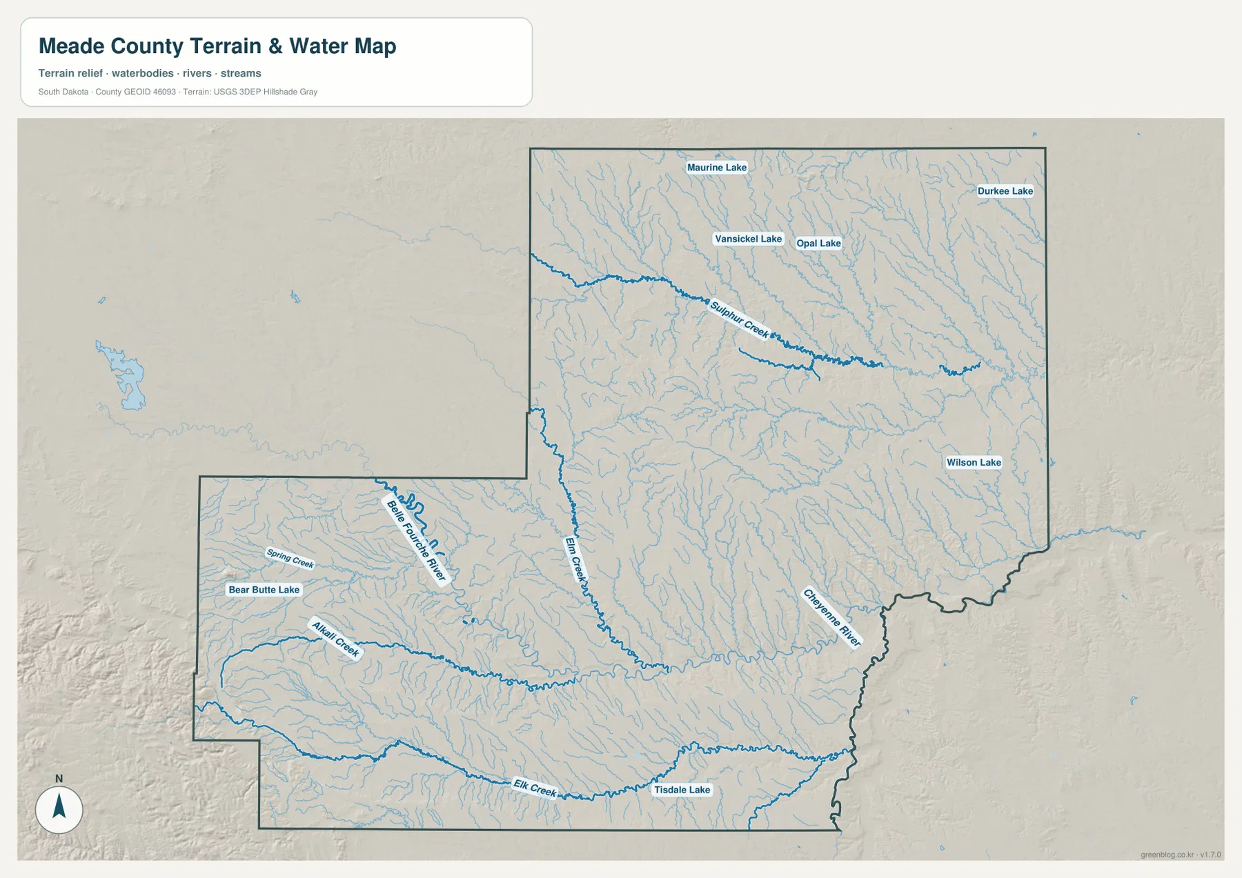
This water layer is intended for names and geographic location. It does not indicate current flow, depth, water quality, flood risk, or navigation conditions, and the blue lines should not be treated as parcel boundaries. For source hydrography or more current water geometry, use an authoritative dataset such as USGS National Hydrography.
The 576–1,661 m elevation range concentrates its highest ground in the southwest
The elevation legend gives an actual minimum near 576 meters, a maximum near 1,661 meters, and a county mean around 841 meters. Brown and tan colors cover much of the western and southwestern edge, showing where the highest terrain is concentrated. The Sturgis-Bear Butte Lake side is especially varied, with steep-looking high ground broken by narrow green valleys.
Farther north and east, green tones cover broader areas. Those lower parts are still heavily dissected by streams, so they do not appear as a featureless flat plain. Sulphur Creek and its tributaries carve through the north, while the Cheyenne River and other valleys create pronounced lower corridors toward the southeast. The map therefore shows both a large regional drop from southwest to east and many smaller valley changes within the lower terrain.
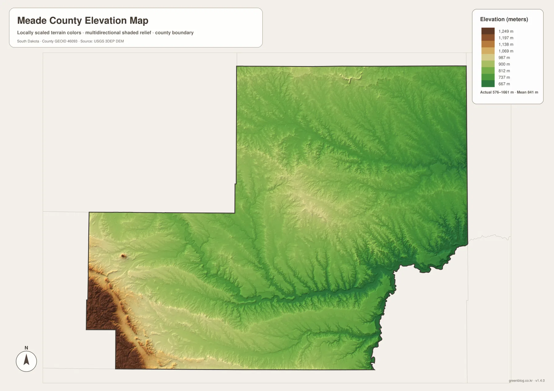
The colored elevation surface is designed for county-scale comparison rather than site measurement. It cannot provide a survey-grade elevation for a road point, field corner, home site, or engineering project. Exact point elevations should be checked against official DEM products such as the USGS 3D Elevation Program or an appropriate local survey.
Compare Faith with Bear Butte Lake to see the county’s strongest contrast
Faith and Bear Butte Lake make useful opposite reference points. Faith sits near the northeastern edge and is shown 85 straight-line miles from Sturgis. On the elevation map, that part of the county is dominated by lower green tones, while the water map shows the broad Sulphur Creek tributary network and several northern lakes nearby. It represents the open, lower side of the county more clearly than the compact southwestern road cluster does.
Bear Butte Lake lies close to the opposite corner, near Sturgis and the western road concentration. The elevation image shows some of the county’s highest colors in the same general area, while Spring Creek and Alkali Creek cut through the western relief. Switching between these two ends of the county makes it easy to connect settlement spacing, drainage, and elevation without turning the article into a list of unrelated map features.
The WebP images in the article are optimized for convenient screen viewing. The download archive contains the matching original JPG files for the general county map, city-connections map, terrain-and-water map, and elevation map. Each JPG is 3638 × 2572 pixels, making the files more suitable for A3 printing, classroom use, presentations, and closer inspection of roads and labels.
Frequently Asked Questions
Is the 85-mile Sturgis-to-Faith label a driving distance?
No. The city-connections map identifies it as a direct straight-line distance. Piedmont at about 15 miles and Summerset at about 19 miles use the same direct-distance method. Actual road mileage can be longer.
Which map is best for locating Sulphur Creek and the Cheyenne River?
The terrain-and-water map is the clearest choice. It labels Sulphur Creek across the north and also shows Elm Creek, the Cheyenne River, Elk Creek, Alkali Creek, Bear Butte Lake, Tisdale Lake, and several northern lakes.
Can the 576–1,661 m elevation range be used as an exact property elevation?
No. Those figures describe the county-wide elevation range, and the color surface is intended for broad terrain comparison. Use official DEM or survey data when you need a precise elevation at a specific location.
Map File Information
The ZIP contains the original high-resolution JPG files for the Meade County general map, city-connections map, terrain and water map, and elevation map.
- Included Files: 4 JPG maps
- Printable Size: 3638 × 2572 px each
Related Maps
Sources and references
- U.S. Census Bureau TIGER/Line Shapefiles – official geographic source for county boundaries and base mapping data.
- USGS National Hydrography – official source for rivers, streams, lakes, and hydrographic data.
- USGS 3D Elevation Program – official source for elevation and DEM products.
- 2020 Census PL County Name API – Census API that can be used to verify Meade County, South Dakota identifiers.
Green Map creates custom-edited map images using open geographic data sources such as geoBoundaries, Natural Earth, OpenStreetMap, and government open data.
These maps are edited visual materials, not raw data files, and are provided for education, documents, presentations, and graphic reference.