Download the high-resolution Custer County South Dakota Map JPG files from the ZIP provided on this page. Custer is the clearest settlement to use for orientation, with route 16 entering from the west and US 385 continuing south. Hermosa lies in the northeast, Fairburn is farther south, and Pringle is below Custer. The water and elevation views add a strong physical contrast: small lakes and creeks occupy the higher western country, while the terrain falls sharply toward the lower eastern half of the county. The supplied elevation map reports an actual range of 756 to 2112 meters.
Custer County makes more sense when places are followed across roads, water, and relief rather than treated as separate lists. Starting in Custer, the map can be read north and east toward Hermosa, south toward Pringle, or across the creek network toward Fairburn and the eastern boundary. The elevation colors then explain why the western and eastern parts of the county look so different even when they are connected by the same road system.
Table of Contents
Custer is the road anchor for the western half of the county
The general county map places Custer near the west-central part of the county. Route 16 reaches the city from the west, while 16A and route 36 continue toward the Hermosa side of the county. US 385 and route 87 extend south from the Custer area toward Pringle and the southern boundary. Because several major routes meet or pass close to Custer, the town is the easiest place to begin reading the map.
Hermosa appears near the northeastern side and Fairburn is farther south. Route 79 continues through the eastern-southern area, and route 40 reaches the irregular eastern county line. Pringle lies south of Custer, with route 89 visible closer to the southwestern boundary. The map is useful for geographic orientation, but live traffic, road work, closures, and driving time should be checked with a current transportation source.
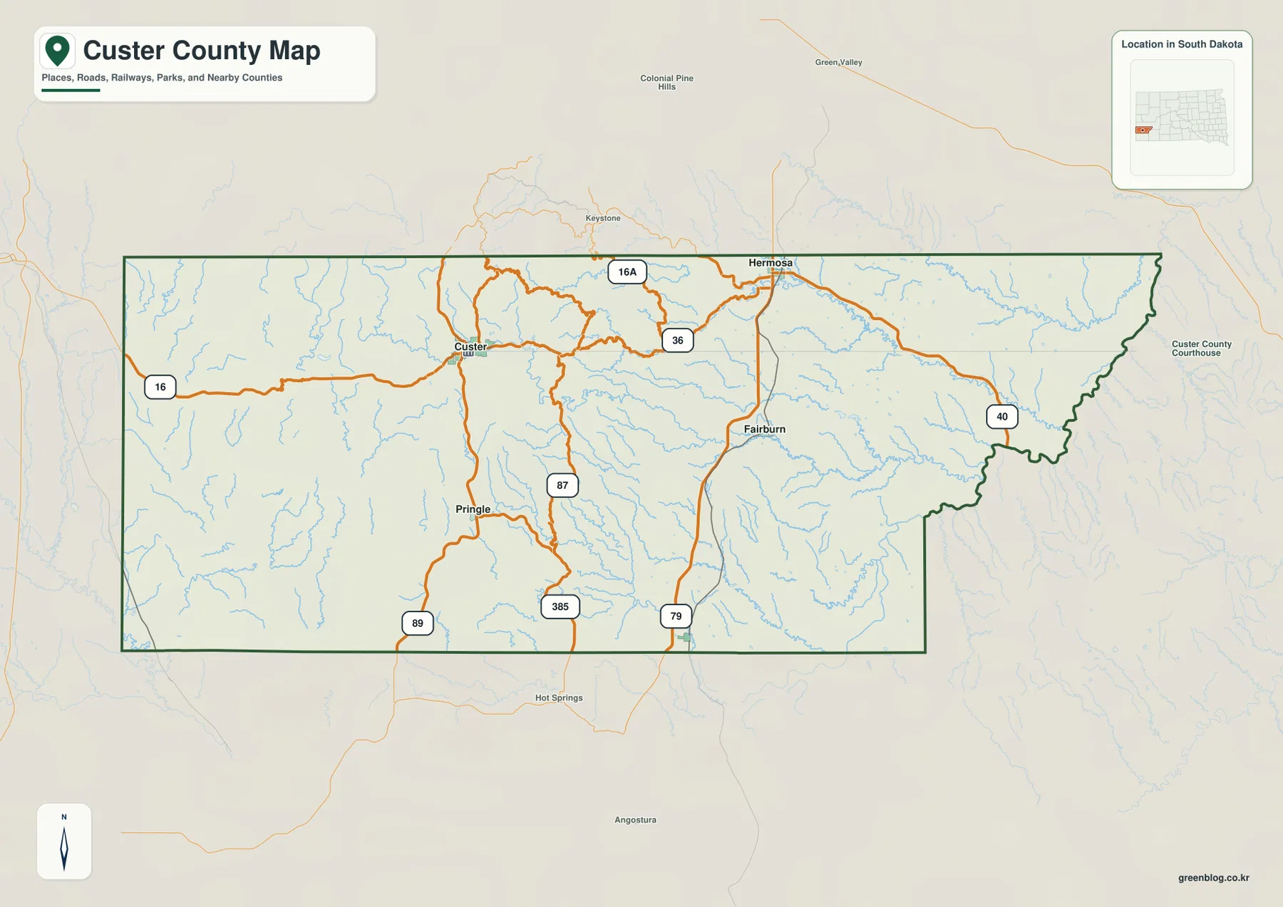
The eastern boundary has several bends instead of one uninterrupted straight line. Route 40 approaches this irregular side near the Fairburn area. That shape becomes easier to understand once the water and elevation views are considered, because the eastern side is much lower than the high western terrain.
Custer County’s official website lists the Custer County Courthouse at 420 Mount Rushmore Road in Custer. That administrative location matches the visual role of Custer on the map: it is one of the most important reference points for roads and settlement in the western half of the county.
Custer, Hermosa, Pringle, Buffalo Gap, and Fairburn occupy very different parts of the county
The city-index image includes five ranked communities: Custer, Hermosa, Pringle, Buffalo Gap, and Fairburn. Their positions are more useful than the rank order by itself. Custer is west-central, Hermosa is northeast, Pringle is farther south, Fairburn is east of center, and Buffalo Gap appears near the southern edge. The distribution shows that the county’s named settlements are widely spaced rather than concentrated in one compact cluster.
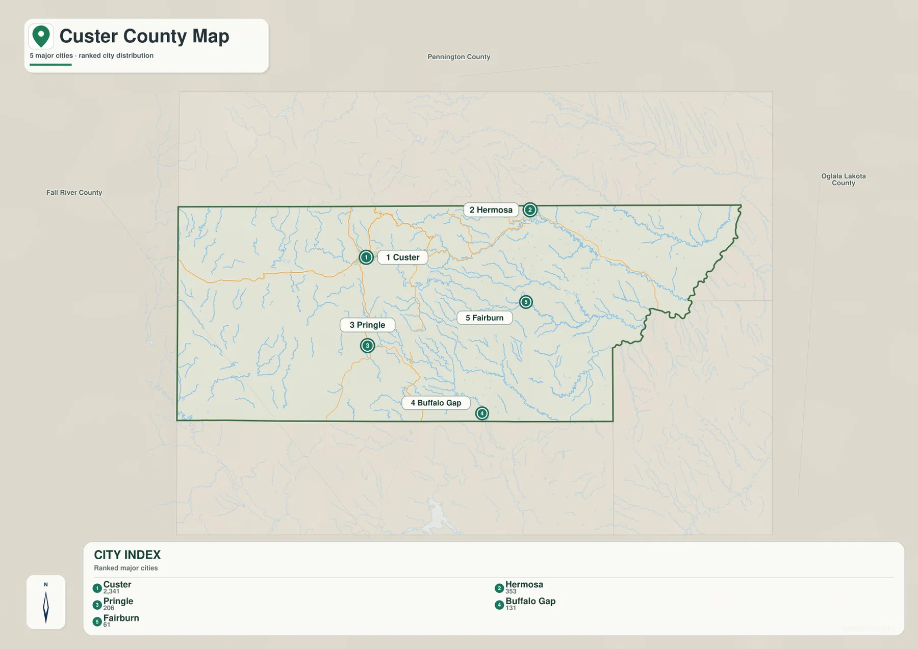
The printed CITY INDEX shows Custer 2,341, Hermosa 353, Pringle 206, Buffalo Gap 131, and Fairburn 61. This article treats those figures only as values printed on the supplied image, not as current population estimates. The latest population should be checked separately with the U.S. Census Bureau when that information matters.
The city image is not a hub-and-distance diagram, so the rank markers should not be interpreted as straight-line mileage or driving distance from Custer. Use the general county map for road context and a current navigation service for mileage and travel time.
Western lakes feed into a dense creek network across the county
The terrain-and-water view places Sylvan Lake, Bismarck Lake, Stockade Lake, and Center Lake in the higher western-northwestern part of the county. The surrounding terrain is visibly rugged, and Grace Coolidge Creek carries water eastward from the same general area. Dry Creek and French Creek run farther south, giving the central part of the county a series of long east-west drainage lines.
Battle Creek becomes the strongest named stream in the northeast and eastern part of the map. Spring Creek lies farther north. In the south, Beaver Creek and Lame Johnny Creek cross the interior, while Pass Creek appears in the southwest. Cottonwood Creek and the Cheyenne River label are visible toward the lower-right side of the water map, adding additional reference points close to the southeastern edge.
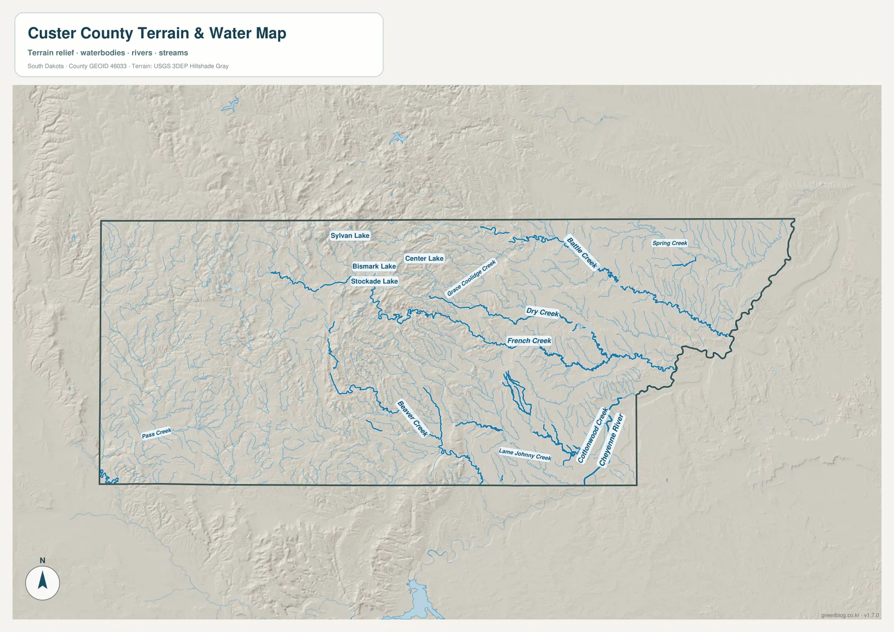
French Creek is especially useful as a cross-map feature because it runs through the central county between the Custer area and the east. Grace Coolidge Creek lies farther north, while Battle Creek occupies the northeast-to-east corridor. These waterways make it clear that the county’s high western terrain is divided by numerous valleys rather than forming one continuous plateau.
The water image is a location reference rather than a live hydrologic product. It does not report current lake level, streamflow, flood risk, water quality, fishing conditions, or boating safety. Current field conditions should be checked with USGS or local authorities.
Elevation drops dramatically from the western highlands into the eastern lowlands
The elevation map reports an actual county range of 756 to 2112 meters and a mean of 1287 meters. Browns and dark browns dominate much of the west and northwest, showing the highest broad terrain. Toward the center, the colors shift through yellow and light green. The eastern half is largely green, indicating much lower terrain than the western side.
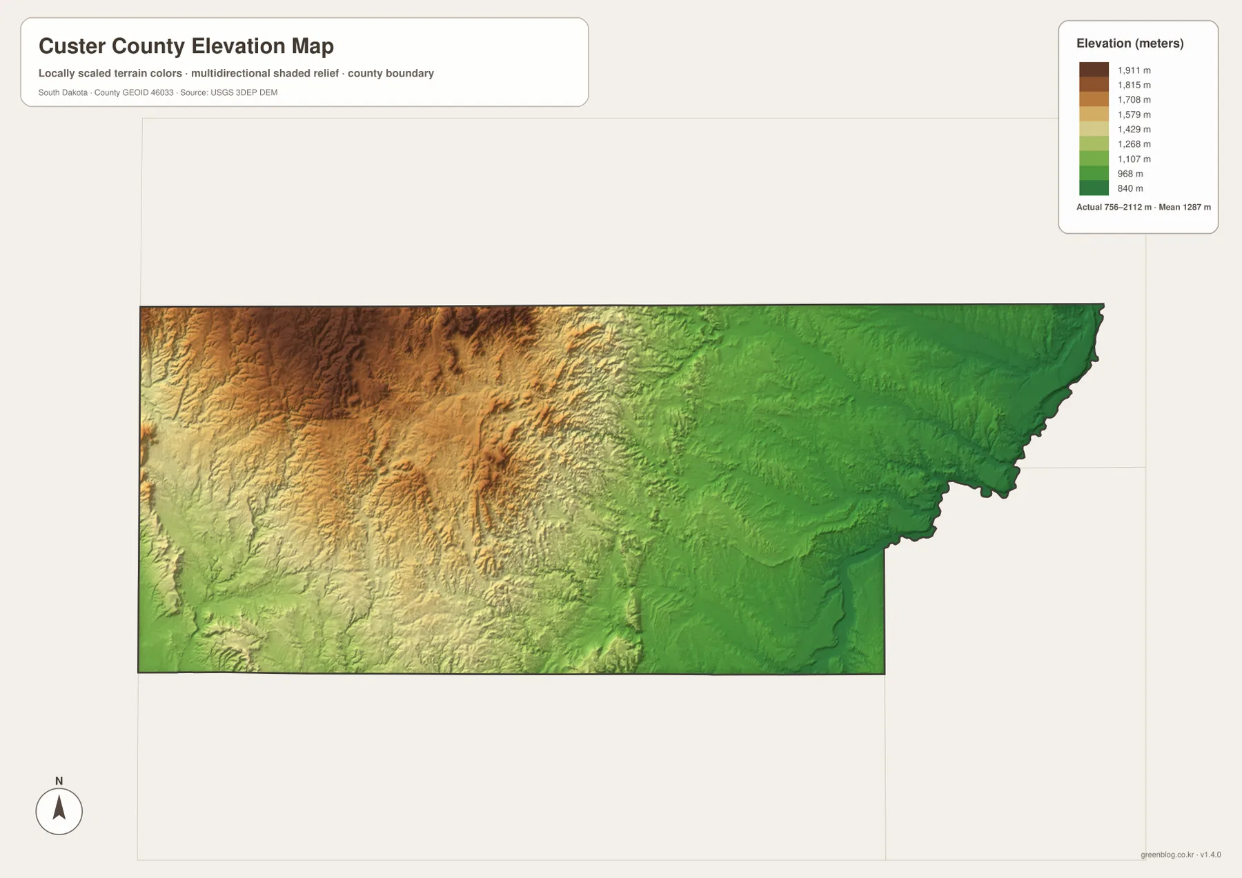
The contrast becomes easier to understand when settlement positions are added. Custer and the western lake area sit among the stronger high-elevation colors. Hermosa is closer to the transition zone, while Fairburn and much of the eastern edge occupy the lower green terrain. The road network therefore crosses a major change in relief as it moves from west to east.
The 756–2112 meter range is appropriate for county-scale comparison, not parcel, building, or engineering measurement. A precise elevation for a road point or property should be checked with detailed USGS 3DEP data or a professional survey.
Follow Custer eastward to connect roads, creeks, and the elevation change
Custer works well as a cross-map anchor. The general map ties it to route 16 and US 385. The water view places the western lakes and French Creek nearby, and the elevation surface shows that this same part of the county is among the highest. Moving toward Hermosa and Fairburn introduces Battle Creek and progressively lower terrain, so the west-to-east change can be followed without losing the settlement references.
Pringle and Buffalo Gap provide a southern comparison. Pringle is tied to the southbound road network from Custer, while Buffalo Gap appears near the southern boundary in the city index. Beaver Creek and Lame Johnny Creek give the southern interior natural reference lines, and the elevation map shows how the southern relief changes from west to east as well.
The ZIP below contains the general county, city, terrain-and-water, and elevation maps as original high-resolution JPG files. Each image is 3638 × 2572 pixels and is suitable for printing, classroom handouts, presentations, or close viewing. Legal boundaries, live road conditions, current water information, flood decisions, and survey-grade elevation require current authoritative data in addition to these reference maps.
Frequently Asked Questions
Why does Custer County show such a large west-to-east elevation difference?
The supplied elevation map shows high terrain concentrated across much of the west and northwest and much lower green terrain across the east. The reported county range is 756 to 2112 meters, so the broad difference is substantial even before local valleys and ridges are considered.
Can Sylvan Lake and Center Lake be seen on the same water map?
Yes. The terrain-and-water view labels Sylvan Lake, Bismarck Lake, Stockade Lake, and Center Lake in the western-northwestern part of the county and also shows French Creek, Grace Coolidge Creek, Battle Creek, and several southern streams.
Is Custer 2,341 in the CITY INDEX a current population estimate?
This article treats Custer 2,341 and the other numbers only as values printed in the supplied CITY INDEX. They should not be assumed to be the latest population estimates. Use current U.S. Census Bureau data when present-day population is important.
Map File Information
The Custer County general, city, terrain-and-water, and elevation views are packaged as high-resolution JPG files.
- Included Files: Use only the versions confirmed in the article and supplied images
- File Type: Use the confirmed download contents
- Intended Use: Printing, education, presentations, and map-based projects
Related Maps
Sources and References
The article is based first on the names, roads, water features, and elevation values visible in the supplied Custer County maps. These official sources provide additional county, statistics, boundary, hydrography, and elevation reference information.
- Custer County, South Dakota official website
- U.S. Census Bureau QuickFacts – Custer County
- U.S. Census Bureau TIGER/Line Shapefiles
- USGS National Hydrography
- USGS 3D Elevation Program
Green Map creates custom-edited map images using open geographic data sources such as geoBoundaries, Natural Earth, OpenStreetMap, and government open data.
These maps are edited visual materials, not raw data files, and are provided for education, documents, presentations, and graphic reference.