Sitka is the obvious population center on these maps, but the municipal outline tells a much larger story. The road and facility symbols cluster around Sitka on the west side of the borough, while the boundary continues far south along Baranof Island toward Port Armstrong and spreads north through a broken landscape of islands, bays, and channels. This page uses the mapped places and water features to explain that contrast. The same high-resolution JPG originals represented by the web previews are available together in the download archive below.
The general view puts several different kinds of labels inside one long coastal boundary. Sitka is prominent, Baranof and Port Armstrong appear much farther south, Cobol is identified as historical, and Mount Edgecumbe Hospital is shown as a facility label. Outside the boundary, names such as Tenakee Springs and Angoon help orient the reader to the surrounding part of Southeast Alaska. The pattern is useful because it prevents the borough from being mistaken for a compact city area with the same kind of road access everywhere.
Water provides an even better frame of reference. Sitka Sound lies off the western coast, Port Frederick and North Arm Hoonah Sound appear in the north, and Frederick Sound is labeled to the east. Black River, Kadashan River, Clear River, Glacial River, Katlian River, and Baranof River are among the waterways named inside the mapped area. Once those features are placed beside the city and boundary maps, the long island municipality becomes easier to understand as a series of mountainous coastal sections rather than a single road-connected block.
Table of Contents
Sitka occupies one small part of a long coastal municipality
The most important scale difference is visible before any individual road or river is examined. Sitka sits in the northern half of the mapped borough, yet the boundary extends a great distance beyond the developed-looking area. To the south, Baranof Island narrows into a long coastal section that reaches toward Port Armstrong. To the north and northwest, the outline breaks around islands, inlets, and irregular shorelines. That combination makes the municipal area look very different from a typical inland county drawn around a connected highway system.
The city-distribution map adds neighboring county-equivalent names for orientation. Hoonah-Angoon Census Area appears to the northeast, Prince of Wales-Hyder Census Area is labeled to the west, and Juneau City and Borough is shown farther southwest in the regional background. These labels are useful for understanding direction, but they should not be interpreted as a road map. In Southeast Alaska, short straight-line separations can cross water or rugged land, so actual travel planning requires current transportation information that is not contained in this map set.
Road detail reinforces the same point. Lines and facility symbols are easiest to see near Sitka, while large portions of the borough have very little comparable road information. There is no single road drawn from the Sitka area through the entire southern section to Port Armstrong. The maps therefore work best when the community and the municipality are treated as two scales: a concentrated settlement area around Sitka and a much larger administrative boundary made up mostly of island, mountain, and coastal terrain.
The boundary map connects Sitka with Baranof and Port Armstrong
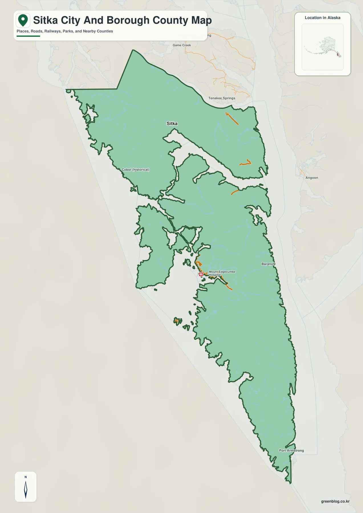
For an overall regional view, the boundary map is the clearest place to begin. Sitka and its nearby road symbols occupy a relatively small area in the upper half of the image. Moving south, the Baranof label appears before the map reaches Port Armstrong near the far southern end. Seeing those names in one frame gives a better sense of distance within the borough than a close-up map of downtown Sitka could provide.
The shoreline itself deserves attention. Small islands and narrow coastal indentations make the northwestern side especially irregular. Farther south, the land remains long and narrow rather than opening into a broad plain. Bays and channels cut deeply into the outline in several places, while the central and southern sections preserve a strongly coastal shape. Following the dark green boundary is often the easiest way to keep track of which pieces belong to the borough when the shoreline becomes visually complicated.
Not every printed name represents the same kind of place. Cobol carries a historical label, Mount Edgecumbe Hospital is a facility, and some names outside the green line serve only as regional reference points. That distinction matters when the map is used in a school assignment or presentation. A label can help a reader find a location without being part of a current incorporated-city list, so the general map should be read as a broad geographic reference rather than a directory of settlements.
The boundary line is also not a substitute for a parcel survey or legal land description. It is suitable for understanding the borough at a regional scale, but projects that depend on authoritative current boundaries should use official geographic sources such as U.S. Census Bureau TIGER/Line data. The map on this page is intended to make the shape and location of the borough easier to see, not to resolve property or survey questions.
A one-entry city index says more about the map than the borough
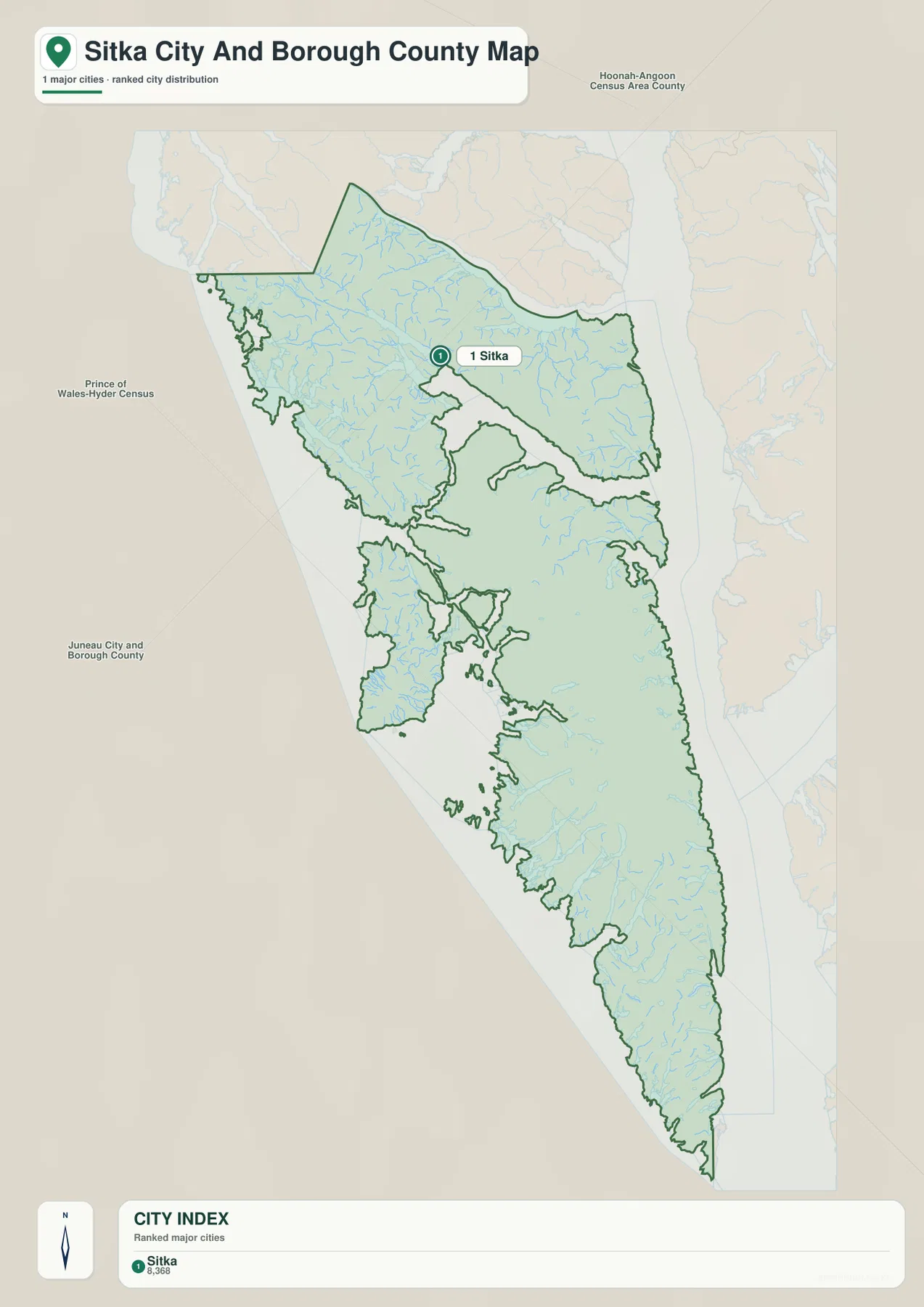
The CITY INDEX at the bottom of the map contains one ranked entry: Sitka. A value of 8,368 is printed beside the name, but the supplied image does not state the reference year. For that reason, the number should not be copied into a current population table without checking a dated statistical source. On this page, the safest use of the index is to locate Sitka quickly and understand where that city sits inside the much larger borough boundary.
A one-entry index does not mean that the borough contains no other named places. The general map still shows Port Armstrong, Baranof, Cobol (historical), and other labels that do not appear in the ranked list. The city layer has simply been simplified around its ranking rule. That makes it effective for a slide where Sitka needs to stand out, but less useful as a complete place-name reference. Readers who need both the ranked city and the broader geographic setting should compare the two maps rather than treating either one as a complete directory.
The marker also illustrates the difference between settlement location and municipal extent. Sitka appears in the upper half of the borough, while the green outline continues far to the south and through many areas with no comparable urban label. That visual contrast is useful in discussions of administrative geography because it shows why the words “Sitka City and Borough” refer to more than the built-up community alone.
Sounds, rivers, and steep relief define the rest of the picture
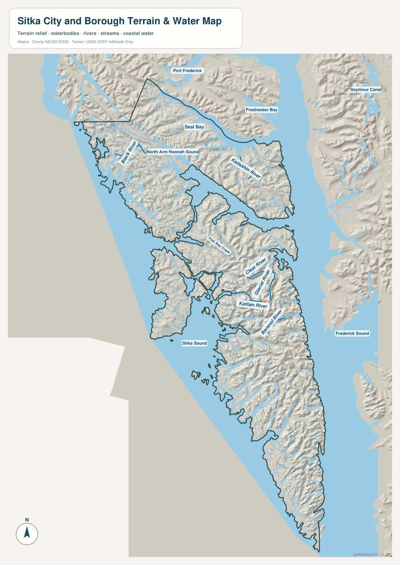
The terrain-and-water view makes the coastal setting impossible to miss. Sitka Sound forms a broad western reference, while Port Frederick and North Arm Hoonah Sound sit along the northern part of the map. Seal Bay is labeled inside that northern section. Freshwater Bay and Seymour Canal appear beyond the borough on the northeast side, and Frederick Sound provides a large eastern reference. These water names are especially useful when the municipal boundary alone feels difficult to follow.
Named rivers add smaller reference points across the mountainous land. Black River and Kadashan River are shown in the north. Farther south, Fish Bay Creek, Clear River, Glacial River, Katlian River, and Baranof River appear in valleys that lead toward the coast. The streams do not form the kind of broad, lowland river network seen on many continental county maps. Instead, many of them look relatively short and closely tied to steep coastal terrain.
Shaded relief helps explain why. Ridges and valleys cover much of the mapped land, including the long southern section of Baranof Island. Small streams repeatedly descend toward both sides of the island, and there is little visual evidence of a broad continuous plain. The relief is useful for comparing the shape of the terrain, but it does not provide contour elevations or engineering measurements. It should be treated as a visual terrain reference rather than a source for calculating exact height or slope.
The map is not a nautical chart or flood-hazard product either. It does not contain depth soundings, tide data, reef hazards, navigation channels, flood probabilities, or evacuation zones. Boating, emergency planning, engineering, and other safety-sensitive work require current purpose-specific official products. USGS National Hydrography can be used as a companion source when formal river and water-feature names need to be checked.
Which file works best for a printout or location check?
A regional overview usually benefits from the boundary map because it keeps Sitka, Baranof, Port Armstrong, surrounding reference names, and the full outline together. When the purpose is simply to emphasize where Sitka lies within the municipality, the ranked city version is cleaner because the single numbered marker draws attention immediately. A report that discusses island channels, rivers, or mountainous coastlines will usually need the terrain-and-water version instead, since it carries the most physical-geography detail.
These are reference maps rather than route planners. The city layer does not show travel times, the general map does not establish legal parcel boundaries, and the water layer does not provide marine navigation data. Used within those limits, the files work well for classroom material, regional introductions, presentations, and personal map projects where the goal is to show location and geographic context clearly.
The WebP images embedded in the article are reduced for web viewing. If small labels need to be enlarged or the map will be printed, the original JPG files in the ZIP archive are the better choice. The archive contains the general boundary map, ranked city map, and terrain-and-water map, with each JPG measuring 2572 by 3638 pixels. That extra resolution is useful for large screens, presentation slides, and printed handouts.
Frequently Asked Questions
Why does the ranked city map list only Sitka?
The city layer is a ranked major-city index rather than a complete list of every named place in the borough. Sitka is the single ranked entry, while the general map also labels places such as Port Armstrong, Baranof, and Cobol (historical). Use the boundary map when you need the wider place-name context.
Is the 8,368 value in the CITY INDEX Sitka’s current population?
It should not be treated as a current population figure without a dated source. The map shows 8,368 but does not identify the reference year in the supplied image. For a current demographic figure, check U.S. Census Bureau QuickFacts or another source that states its date and methodology. On this map, the index is best used for location and ranking.
Can the terrain-and-water map be used for marine navigation?
No. It is a geographic reference showing the relative positions of Sitka Sound, Port Frederick, rivers, coastline, and terrain. It does not include depths, tides, navigation hazards, or other marine-safety information. Actual vessel navigation requires current official nautical products designed for that purpose.
Map File Information
The ZIP archive contains high-resolution JPG originals covering the full Sitka City and Borough boundary, Sitka's ranked city location, and the area's mountainous coastal waterways.
- Included Files: General map, ranked city map, and terrain-and-water map JPGs
- Printable Size: 2572×3638 pixels each
Related Maps
Sources and References
- City and Borough of Sitka – GIS & Map Resources: official local GIS and mapping resources
- City and Borough of Sitka – Planning & Community Development: official planning and local reference material
- U.S. Census Bureau QuickFacts – Sitka City and Borough: dated population and area statistics
- U.S. Census Bureau TIGER/Line Shapefiles: authoritative county-equivalent boundary geography
- USGS National Hydrography: official reference for rivers, streams, and hydrographic names
Green Map creates custom-edited map images using open geographic data sources such as geoBoundaries, Natural Earth, OpenStreetMap, and government open data.
These maps are edited visual materials, not raw data files, and are provided for education, documents, presentations, and graphic reference.