Jersey County, Illinois combines a large agricultural interior with a much more wooded southwest and a visible band of water along the western boundary. The 2025 summary lists agriculture at 58.05% and forest at 29.16%, followed by developed land at 8.09%, wetlands at 2.53%, and water at 2.06%. The contrast is geographic as well as numeric: fields are broadest across the north and east, while forest and water become much more prominent toward the west and southwest.
The page includes four different map views, and the original JPG set is available in one download. Start with the general land cover map for the countywide mix, use the impervious map to locate hard-surface concentrations, compare forest and farmland for the strongest regional contrast, and turn to the 1985–2025 layer when the question is classification change rather than current cover.
Table of Contents
The countywide mix shifts sharply between the agricultural northeast and the wooded southwest
Across the north and east, agriculture forms broad yellow blocks that are interrupted mainly by roads, small wooded pieces, and scattered developed cover. The central portion remains heavily agricultural, but a large developed cluster creates a clear red concentration near the middle of the map. Moving west and south, the balance changes as forest becomes more continuous and the edges between fields and woods grow more irregular.
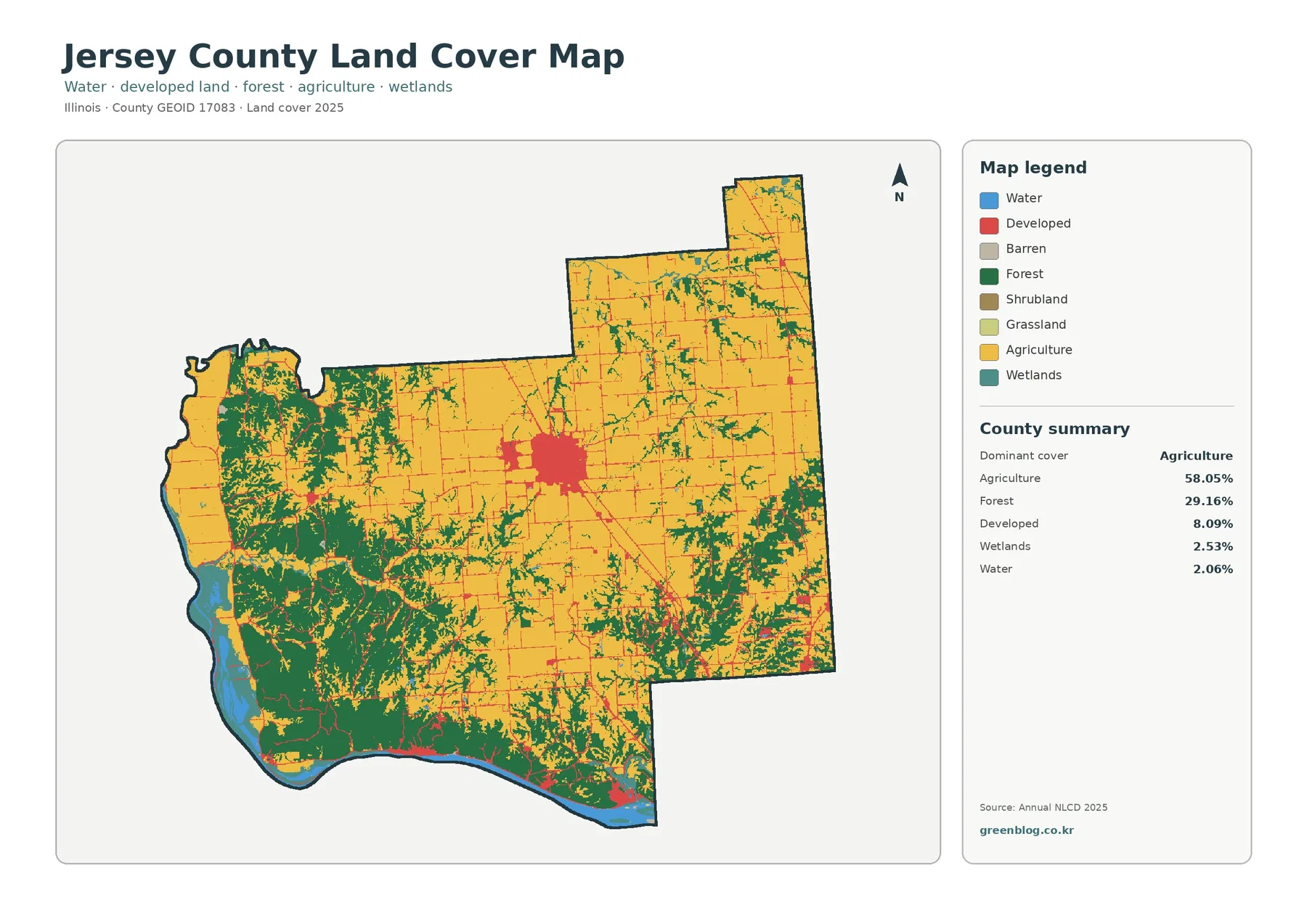
The forest share is large enough to shape entire sections of the county rather than appearing only as isolated fragments. In the southwest, green cover occupies broad connected areas and wraps around parts of the water edge. Western forest patches also extend northward, while the eastern half contains smaller, more fragmented wooded strips within the farm matrix.
Water is only 2.06% of the county summary, yet its location makes it visually important. A blue strip follows much of the western boundary and continues through the curved southwestern edge. Nearby wetlands and forest create a layered transition that looks very different from the large field blocks in the northeast. The map therefore has a strong east-west contrast even though agriculture remains the dominant countywide class.
The impervious map separates one major built center from a largely low-hard-surface county
Impervious surface means pavement, rooftops, parking areas, and other hard surfaces that do not readily absorb water. Jersey County has a mean impervious value of 1.75%, and 0.66% of the county is mapped at 50% impervious or greater. These values are much lower than the 8.09% developed-land share because developed land-cover classes can include lawns, trees, and other permeable surfaces.
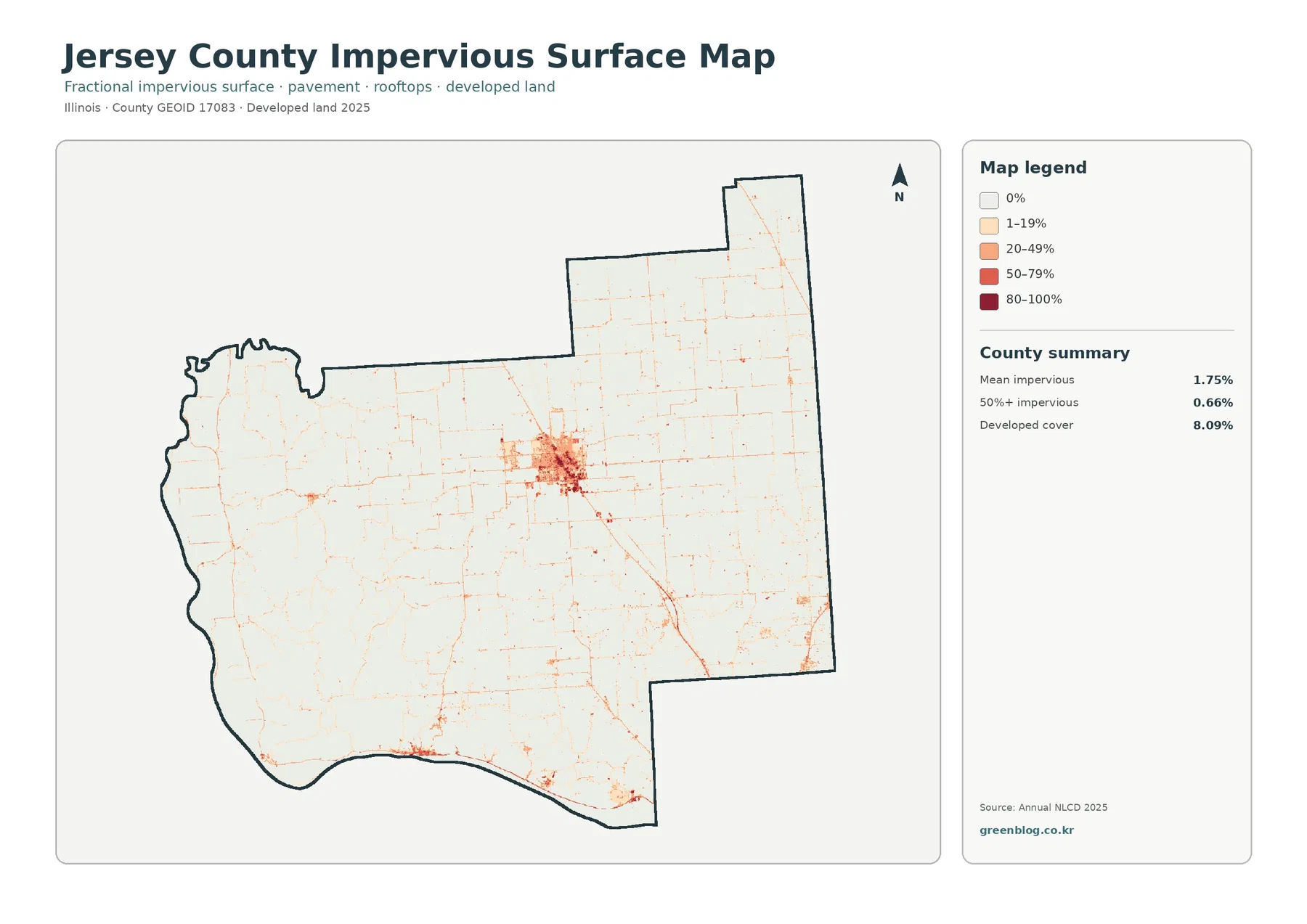
This pattern helps explain why a noticeable developed class can coexist with a low countywide impervious mean. Development is concentrated in a few places, while most farm and forest areas contain little pavement or rooftop cover. The impervious layer is useful for comparing those concentrations, but it should not be treated as a flood or drainage map because runoff also depends on terrain, soils, rainfall, drainage systems, and nearby water levels.
Forest and farmland reveal a broad southwest woodland beside a more open eastern farm landscape
The forest-and-farmland view simplifies the map by reducing the visual emphasis on developed land. Agriculture still covers 58.05%, but the 29.16% forest share becomes much easier to follow. Large wooded areas dominate much of the southwest and extend through western sections, while the north and east show larger and more continuous agricultural blocks.
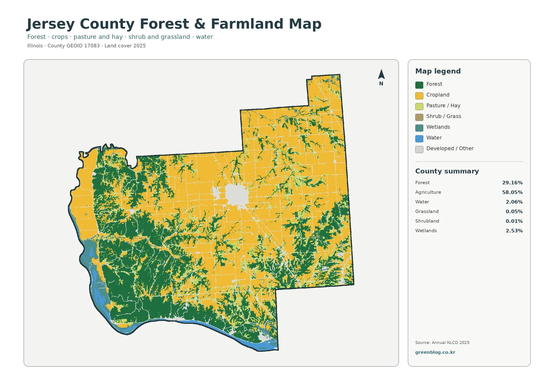
The transition is not a straight line. Central Jersey County contains a patchwork in which agricultural blocks, forest strips, and developed cover meet at irregular edges. Farther west, forest becomes more continuous and is often close to water or wetland cover. Farther east, forest is usually narrower and more fragmented within the agricultural matrix.
Grassland is listed at only 0.05% and shrubland at 0.01%, so neither is a defining countywide class. Wetlands at 2.53% are more useful as a secondary feature because their locations often overlap the western and southwestern transition between forest and water. The major story is still the contrast between a large farm share and an unusually substantial wooded share for a county that remains agriculture-dominant overall.
The 1985–2025 layer shows 9.32% class difference, mostly outside the named loss categories
The change map identifies raster cells whose 1985 and 2025 land-cover classifications differ. Jersey County has an overall class-difference value of 9.32%. The summary separates 1.41% classified to developed, 0.65% forest loss, 0.53% agricultural loss, and 6.61% other class difference. The last category is by far the largest component, so the total cannot be reduced to a simple story of development growth or forest clearing.
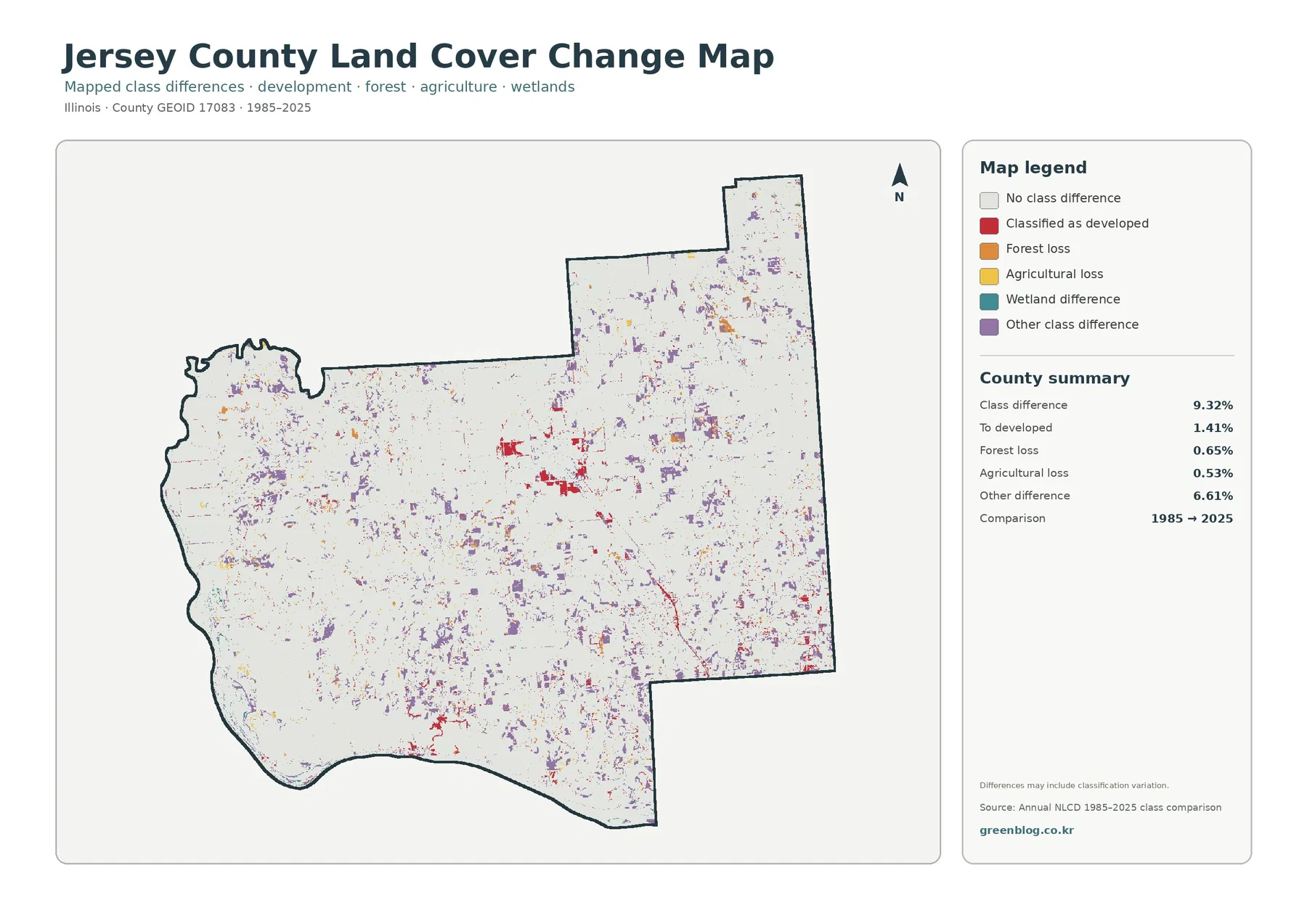
Purple other-class differences are scattered through the north, center, and south and also appear within parts of the wooded west. Red developed differences are most obvious around the current central built area and along a southeast-running corridor. Forest-loss and agricultural-loss cells are smaller and more fragmented, with no single countywide band dominating the map.
A classification difference can reflect real surface change, but it can also result from imagery, vegetation or moisture conditions, classification methods, and mixed pixels. A mixed pixel is a raster cell that contains more than one kind of ground cover. For a specific site, the change map should be used to identify places worth checking rather than as proof that a particular land-use conversion occurred.
Western water and wetland edges add a useful second layer to the field-and-forest comparison
The western boundary is the clearest place to see how water, wetlands, and forest interact. Water follows the county edge, while teal wetland patches and green forest lie beside it in several places. The southwest contains the strongest combination of these classes. In contrast, the northeastern portion is much more open and agricultural, with fewer large forest blocks and little visible open water.
Land-cover colors are not parcel or regulatory boundaries. Wetland-colored cells do not establish a legal wetland, forest colors do not identify ownership or protected status, and developed classes do not show zoning. The maps are county-scale references intended to show broad surface patterns and help identify places where more detailed information may be needed.
A four-map workflow keeps current cover, hard surfaces, and historical comparison from being mixed together
For a quick county overview, the general land cover map is the best starting point because it shows all major classes together. A presentation focused on agriculture and forest will usually be clearer with the forest-and-farmland map. Questions about roads, rooftops, and built concentrations are better answered by the impervious map, while the change layer is specifically for comparing classification endpoints.
Thirty-meter raster cells simplify narrow roads, wetland edges, and small forest fragments
Annual NLCD products are commonly represented with roughly 30-meter raster cells. A raster divides the surface into a grid and gives each cell a representative class or value. Where one cell includes several surfaces—such as cropland beside a road or forest beside a wetland—the map may simplify that mixed ground into one classification or one impervious percentage.
The 2025 map is also a snapshot of one classification year. Later construction, crop changes, vegetation management, or water-level changes are not automatically included. The 1985–2025 map compares two endpoints and does not reconstruct every event between them. These maps work best for county-scale pattern comparison and as a starting point for more detailed research.
Frequently Asked Questions
What is the largest 2025 land-cover class in Jersey County?
Agriculture is the largest at 58.05%, followed by forest at 29.16%. Agriculture is broadest in the north and east, while forest is much more concentrated in the southwest and western parts of the county.
Why is developed land 8.09% while mean impervious cover is only 1.75%?
Developed land-cover classes can include lawns, trees, soil, and other permeable surfaces. Hard surfaces are concentrated mainly in the central built area and along roads, so the countywide impervious mean remains much lower.
Does the 9.32% 1985–2025 class difference equal physical land-use change?
Not necessarily. Real surface change may be included, but imagery, vegetation, moisture, classification methods, and mixed pixels can also create differences. Other class difference accounts for 6.61%.
Map File Information
The download combines four original JPG maps for Jersey County: 2025 land cover, forest and farmland, impervious/developed land, and the 1985–2025 land-cover class comparison.
- Included Versions: Land Cover Map, Forest & Farmland Map, Impervious/Developed Land Map, and 1985–2025 Land Cover Change Map
- File Type: One ZIP containing four JPG files
- Intended Use: agriculture/forest comparison, western water and wetland review, built-surface patterns, class-change reference, teaching, and presentations
Related Maps
- Adams County Illinois Land Cover Map
- Alexander County Illinois Land Cover Map
- Bond County Illinois Land Cover Map
Sources and references
- MRLC Annual NLCD Data – official access point for Annual NLCD land-cover and impervious-surface products.
- USGS Annual NLCD Land Cover Classification – official documentation for land-cover classes and raster interpretation.
- U.S. Census Bureau TIGER/Line Shapefiles – official geographic boundary source for Jersey County.
Green Map creates custom-edited map images using open geographic data sources such as geoBoundaries, Natural Earth, OpenStreetMap, and government open data.
These maps are edited visual materials, not raw data files, and are provided for education, documents, presentations, and graphic reference.