Caswell County sits along North Carolina’s northern edge, with Virginia immediately beyond the county line. Yanceyville is the county seat and the easiest place to use as a central reference, while the small town of Milton lies much farther north near the Dan River. On the eastern side, Hyco Lake and the streams feeding the Hyco system create a second strong geographic reference. The downloadable set on this page includes a county map, a city map, and a terrain-and-water map, with high-resolution JPG files available in the download box below.
The three views are useful for different reasons. The general county map is best for seeing roads, boundaries, Yanceyville, Milton, and the broad pattern of streams at once. The city map strips away much of that detail so the relationship between the two highlighted towns is easy to grasp. The water map shifts attention to the Dan River, Hyco Lake, Farmer Lake, named creeks, smaller lakes and ponds, and shaded relief. Used together, they make it easier to move from a simple “where is Caswell County?” question to a more practical understanding of how its roads, towns, and waterways fit together.
Table of Contents
A North Carolina border county with Yanceyville near the middle
The Virginia line is the clearest large-scale landmark for Caswell County. Instead of being surrounded only by other North Carolina counties, its entire northern side opens toward Virginia, which makes north-south orientation especially important. Yanceyville is positioned near the middle of the county and serves as the county seat. Milton is close to the northern side, so locating those two towns immediately gives the map a useful center-to-north framework.
The county is largely rural outside its small towns, and the road network spreads out rather than forming a dense urban grid. On the map, US 158 crosses the central part of the county, while NC 86 provides a strong north-south reference through the Yanceyville area. NC 57 is prominent toward the northeast, and NC 62 and NC 119 run away from the central area toward the south. Other visible routes include NC 150 in the southwest, NC 87 near the southern and western side, and NC 49 in the southeast. US 29 appears near the northwestern edge, helping show how the county connects to a larger regional road corridor.
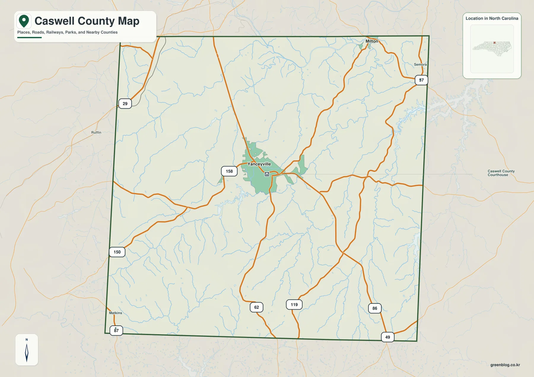
For a quick orientation exercise, start at Yanceyville and trace the numbered highways outward. US 158 gives an east-west reference across the central area. NC 86 makes the north-south relationship easier to see, and the routes branching toward the southeast and southwest help separate the lower half of the county into manageable sections. This is more useful than trying to memorize every small community name at once. Once the road pattern is clear, the town and water maps can be used to add the details that matter for a specific task.
Yanceyville and Milton give the city map two very different anchors
The city view highlights Yanceyville and Milton rather than filling the page with every settlement in the county. That simple choice makes the internal layout easier to read. Yanceyville occupies the central role: it is the county seat, the main labeled population center in this map set, and a place where several roads can be compared. Milton, by contrast, sits near the northern side. The two towns are far enough apart that they work as separate geographic anchors rather than as parts of one continuous built-up area.
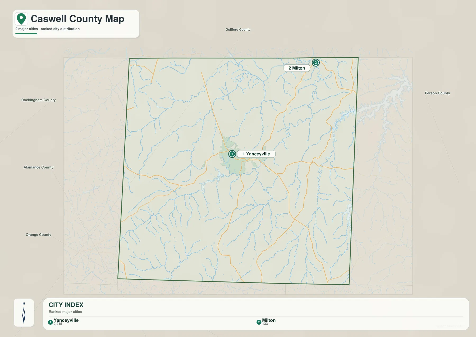
Milton also matters because it sits close to one of the county’s strongest natural features, the Dan River. NCpedia lists Milton among Caswell County’s communities and notes that the Dan River passes through part of the county. That makes Milton a helpful point for switching from the city map to the water map: once the town is found in the north, the nearby river corridor becomes much easier to place. Yanceyville serves a different purpose, connecting the county’s administrative center to the road network and to Farmer Lake farther south.
This map should not be treated as a street-level navigation product. It is better suited to tasks such as explaining where the county seat is, comparing the central and northern parts of Caswell County, planning which detailed map to open next, or adding a clean location graphic to a report, lesson, or travel note. Because the labels are limited, the relationship between the two towns remains visible even at a reduced display size.
Dan River and Hyco Lake define two different sides of the water map
The terrain-and-water map changes the way Caswell County looks. Roads are no longer the main visual feature. Instead, the Dan River is labeled across the northern part of the map, while Hyco Lake stands out on the eastern side with its branching shoreline. NCpedia describes both as important county features, identifying the Dan River as a river that crosses part of Caswell County and Hyco Lake as an important water source and recreation area. Their positions make them practical reference points for distinguishing the north from the east.
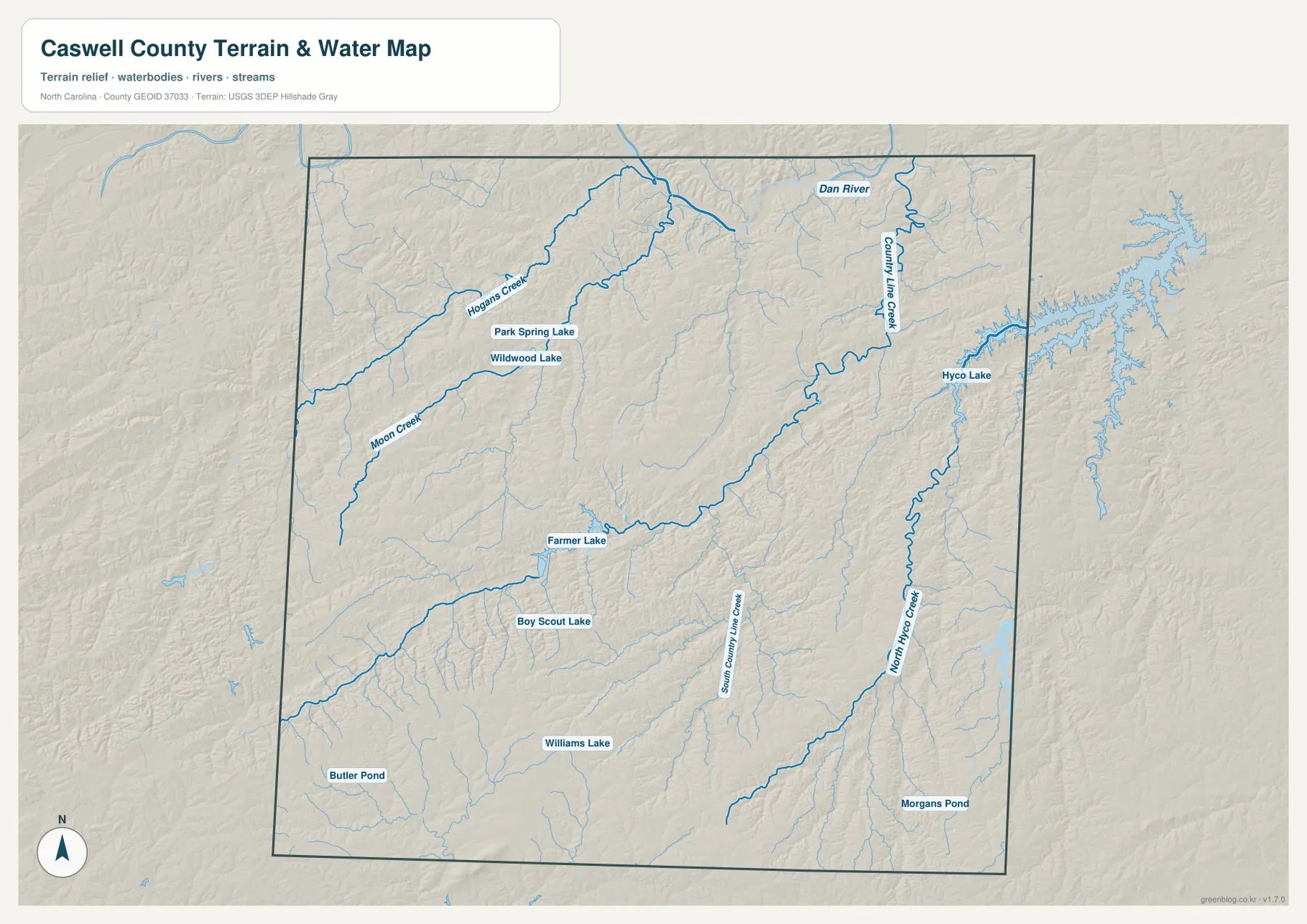
Several named tributaries add useful detail. Country Line Creek is shown in the northeastern part of the county, and North Hyco Creek runs through the eastern and southeastern side. South Country Line Creek is labeled farther south and closer to the center. Hogans Creek and Moon Creek appear in the west and northwest. These names help divide broad rural areas into smaller pieces, especially where there are few large towns to use as landmarks.
The map also identifies Farmer Lake, Boy Scout Lake, Williams Lake, Park Spring Lake, Wildwood Lake, Butler Pond, and Morgans Pond. Farmer Lake is particularly useful because the county government maintains a dedicated page for it. The county describes S.R. Farmer Lake as a 365-acre watershed lake built in 1986 for Yanceyville and used for fishing, boating, and other outdoor recreation. Seeing the lake on the map provides a direct connection between a named local facility and the broader network of creeks and reservoirs across the county.
The shaded background suggests rolling terrain rather than a perfectly flat surface, but this package does not include a separate elevation map. For that reason, the water view should not be used to claim precise elevations, slope percentages, or high and low points. If a project depends on measured elevation, the USGS 3D Elevation Program is the more appropriate source. Here, the relief is best used as a visual aid for seeing how streams occupy valleys and how the county’s drainage lines spread through rural areas.
Match the map to the question instead of using one view for everything
If the question is about boundaries, highways, or how to get oriented around Yanceyville, the general county map is the best starting point. If the goal is simply to show the relative positions of Yanceyville and Milton without a crowded background, the city map is cleaner. For rivers, reservoirs, named creeks, and the shape of the terrain around them, the water map provides the most useful detail. None of these views is meant to replace parcel mapping, flood maps, turn-by-turn navigation, or a current regulatory map, but each is well suited to general reference and presentation work.
A practical way to use the set is to move from roads to water. For example, begin at Yanceyville on the county map, follow US 158 or NC 86 to establish direction, and then open the water map to see where Hyco Lake, North Hyco Creek, or the Dan River lies relative to that road framework. For the northern part of the county, Milton and the Dan River form a useful pair of landmarks. In the south, the combination of NC 62, NC 119, NC 49, NC 87, and the south-flowing creeks helps distinguish areas that otherwise contain relatively few large labels.
- County map JPG: best for the county boundary, Yanceyville, Milton, numbered highways, and an overall location reference.
- City map JPG: best for a simplified comparison of the two highlighted towns.
- Terrain and water map JPG: best for Dan River, Hyco Lake, Farmer Lake, named creeks, smaller water bodies, and shaded relief.
The archive is named caswell_county_north_carolina_3_map_jpg.zip, so the county and state remain clear when the file is stored with other map downloads. Before printing, check the page size and scaling options in the application you are using. The JPGs are intended as high-resolution source files, while the WebP images shown in the article are lighter previews for on-screen browsing.
Frequently Asked Questions
Why is Yanceyville the best first reference point on a Caswell County map?
Yanceyville is the county seat and sits near the central part of the county, where several important roads can be compared. Once it is located, Milton can be placed to the north, Hyco Lake to the east, and the southern highway routes can be followed away from the center. That makes Yanceyville more useful for orientation than starting with a small creek or an outlying road.
How do Dan River and Hyco Lake help separate the northern and eastern parts of the county?
Dan River is the major labeled river across the northern part of the water map, while Hyco Lake is a branching reservoir on the eastern side. Using both at once gives the map two natural anchors: the river helps identify the north, and the lake makes the east easier to recognize. Named tributaries such as Country Line Creek and North Hyco Creek add more detail between those larger features.
Does the download include a separate Caswell County elevation map?
No. This package contains the general county map, city map, and terrain-and-water map only. The water map uses shaded relief in the background, but it does not provide a dedicated elevation layer with measured heights or contour values. For precise elevation work, use an official elevation dataset such as the USGS 3D Elevation Program.
Sources and reference material
- Caswell County official website – county government and community information for Yanceyville and Milton.
- Caswell County – S.R. Farmer Lake – local information about the lake, its size, and public recreation.
- NCpedia – Caswell County – background on county communities, Dan River, and Hyco Lake.
- North Carolina Department of Transportation – County Maps – official county road mapping resources.
- USGS National Hydrography – national hydrography and surface-water reference data.
Map File Information
The download ZIP contains three high-resolution A3-layout JPG maps for Caswell County, North Carolina. Use these larger files when the web previews are not sufficient for a document, presentation, or print layout.
- Included Files: Three high-resolution A3-layout JPG maps: county, city, and terrain-and-water
- File Type: JPG files in one ZIP archive
- Intended Use: Printing, education, presentations, and map-based projects
Related Maps
Green Map creates custom-edited map images using open geographic data sources such as geoBoundaries, Natural Earth, OpenStreetMap, and government open data. These maps are edited visual materials, not raw data files, and are provided for education, documents, presentations, and graphic reference.