Brunswick County occupies a long coastal corner of southeastern North Carolina where inland roads, tidal waterways, river corridors, and Atlantic communities all appear within the same county outline. You can download the three supplied Brunswick County map views from this page as high-resolution A3 JPG files in one ZIP archive, while the web versions below provide a quick preview before downloading. The map does not have one compact center surrounded by evenly spaced towns: Leland and Navassa sit near the northeastern edge toward Wilmington, Shallotte anchors a separate group of places in the southwest, and Oak Island, Southport, Caswell Beach, and Bald Head Island line the southern and southeastern coast. That spread is the most useful starting point for reading the county.
This page provides three related map views rather than treating every local feature as if it belongs on one crowded image. The county map emphasizes boundaries, major roads, settlements, and reference points. The city-distribution map isolates six major labeled communities so their positions can be compared quickly. The terrain-and-water map follows Cape Fear River, Waccamaw River, smaller rivers and creeks, the Intracoastal Waterway, and the Atlantic shoreline. The same three map subjects are available below as high-resolution A3 JPG files in a single ZIP archive.
Bolivia remains an important administrative reference, but it is not the only place that helps explain how Brunswick County works on a map. The courthouse marker lies in the south-central part of the county, while the largest city value shown in the supplied city index belongs to Leland far to the northeast. Coastal places then form another sequence along the southern edge. Looking at those areas separately prevents the county seat, the largest labeled city, and the beach communities from being mistaken for the same geographic center.
Table of Contents
A county map shaped by a long coast and several road directions
The basic county map makes the irregular outline easy to see. Brunswick County narrows and bends along its eastern side, while the southern edge follows a long coastal frontage. Leland and Navassa are clustered near the northeastern corner. Shallotte sits much farther southwest, and Southport occupies the southeastern side near the mouth of Cape Fear River. Oak Island, Holden Beach, Sunset Beach, Caswell Beach, Calabash, and Bald Head Island add a string of coastal names that makes the southern edge look very different from the inland center.
Road numbers give the map a practical structure. Route 17 runs through the Shallotte area and continues toward the northeast, providing one of the clearest links between the southwestern and northeastern portions of the county. Route 211 crosses the central and southern interior toward the coast. Routes 87 and 133 help organize the south-central and southeastern side, while 76 and 140 appear around the Leland-Navassa area. In the southwest, 130 and 904 are useful reference numbers around Shallotte, Calabash, and Sunset Beach.
Those roads do not form one simple spoke pattern around Bolivia. Instead, several corridors meet at different angles because the important places are spread across a wide county. A reader following the road map from Leland to the coast sees a different set of connections than someone looking between Shallotte and Calabash or between Southport and Oak Island. The Brunswick County Courthouse and Brunswick Community College markers provide additional orientation in the interior, especially when a town label is not the easiest feature to spot.
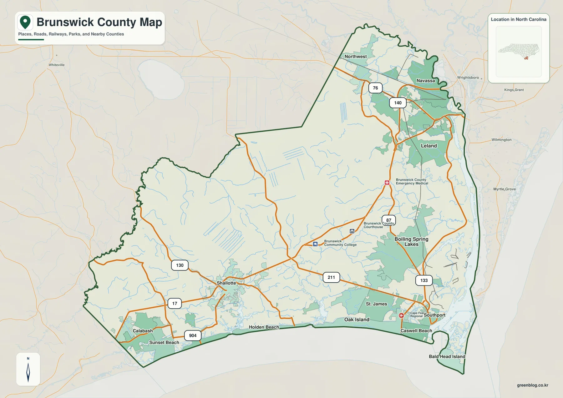
The shoreline labels also help separate the county into recognizable areas. Calabash and Sunset Beach occupy the far southwestern coast. Holden Beach and Oak Island extend across the central-southern shoreline, while Southport, Caswell Beach, and Bald Head Island are grouped closer to Cape Fear River on the east. The county map is therefore the best first file when the task is general orientation, a road-and-place reference, or a printed overview that must show both inland and coastal names without focusing on one data theme.
Leland leads the city index, but the six places form three separate clusters
The supplied city-distribution map ranks six labeled communities and places them inside the county outline. Its index shows Leland at 29,607, Oak Island at 9,030, St. James at 7,072, Boiling Spring Lakes at 6,447, Carolina Shores at 5,017, and Shallotte at 4,639. These are the values printed on the provided map, so they are best used as the map’s internal city index rather than presented as a newly calculated current population table.
Their positions matter as much as the ranking. Leland is clearly separated in the northeastern part of the county. Oak Island and St. James sit near the southern and southeastern coast, with Boiling Spring Lakes just inland to the north. Carolina Shores and Shallotte are concentrated toward the southwest. In other words, the first-ranked place is not surrounded by all of the other five. The map instead shows a northeastern concentration, a southern coastal group, and a southwestern pair.
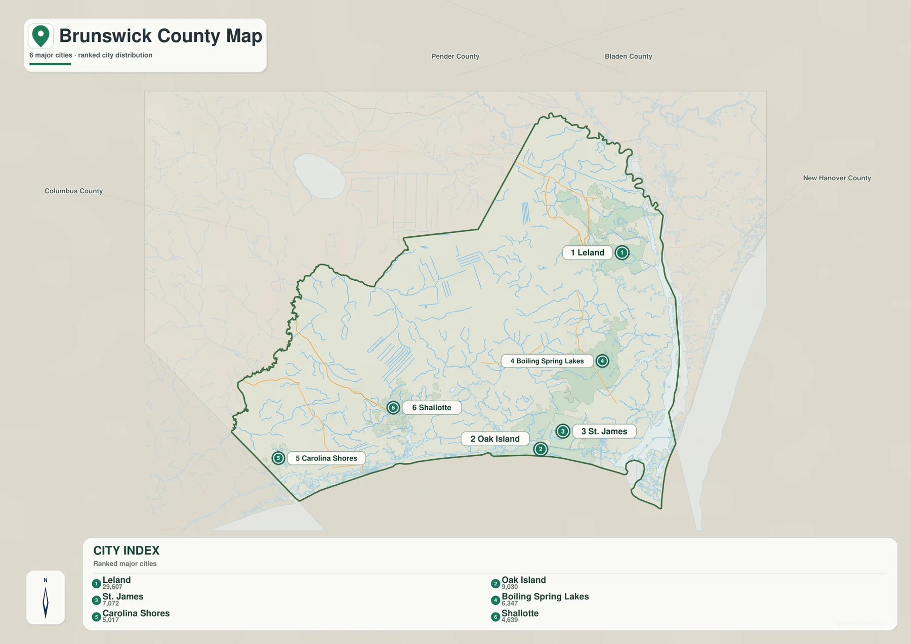
The neighboring-county labels make that pattern even easier to interpret. Pender County and Bladen County appear along the north, Columbus County is shown to the west, and New Hanover County lies to the east. Leland is close to the New Hanover side, while Carolina Shores and Shallotte are much nearer the western and southwestern side of Brunswick County. The map therefore explains why a county-wide trip can involve substantial east-west or northeast-southwest movement even though all six places belong to the same county.
Bolivia is useful here precisely because it demonstrates the difference between an administrative reference and a ranked city list. The six-place city index does not include Bolivia, while the county map marks Brunswick County Courthouse in the south-central interior. When a project needs to show population-oriented place distribution, the city map is the clearer choice. When it needs to show county administration or road orientation, the general county map supplies the better context. Using the two views together avoids assigning every role to Leland simply because it has the largest value in the city index.
Cape Fear River is only one part of a much wider water network
Water dominates the eastern and southern margins of the terrain-and-water map. Cape Fear River runs along the eastern side toward the ocean, while the Atlantic Ocean forms the broad marine edge to the southeast and south. The Intracoastal Waterway is labeled just inside the ocean-facing coast, and Myrtle Grove Sound and Masonboro Inlet appear beyond the county’s eastern side. These features show that Brunswick County’s coast is not represented as a single smooth line; river water, sounds, inlets, island shorelines, and the ocean occur close together.
The western and central parts of the county have their own named waterways. Waccamaw River appears along the western side. Calabash River and Shallotte River are shown in the southwest, with Shallotte Creek entering the same general coastal area. Middle River is labeled farther inland, and Lockwoods Folly River and River Swamp occupy the south-central to southeastern interior. Davis Creek lies near the southern shore, while Hood Creek is labeled much farther north. The number of smaller blue branches between those names reinforces how extensively the county is crossed by drainage channels.
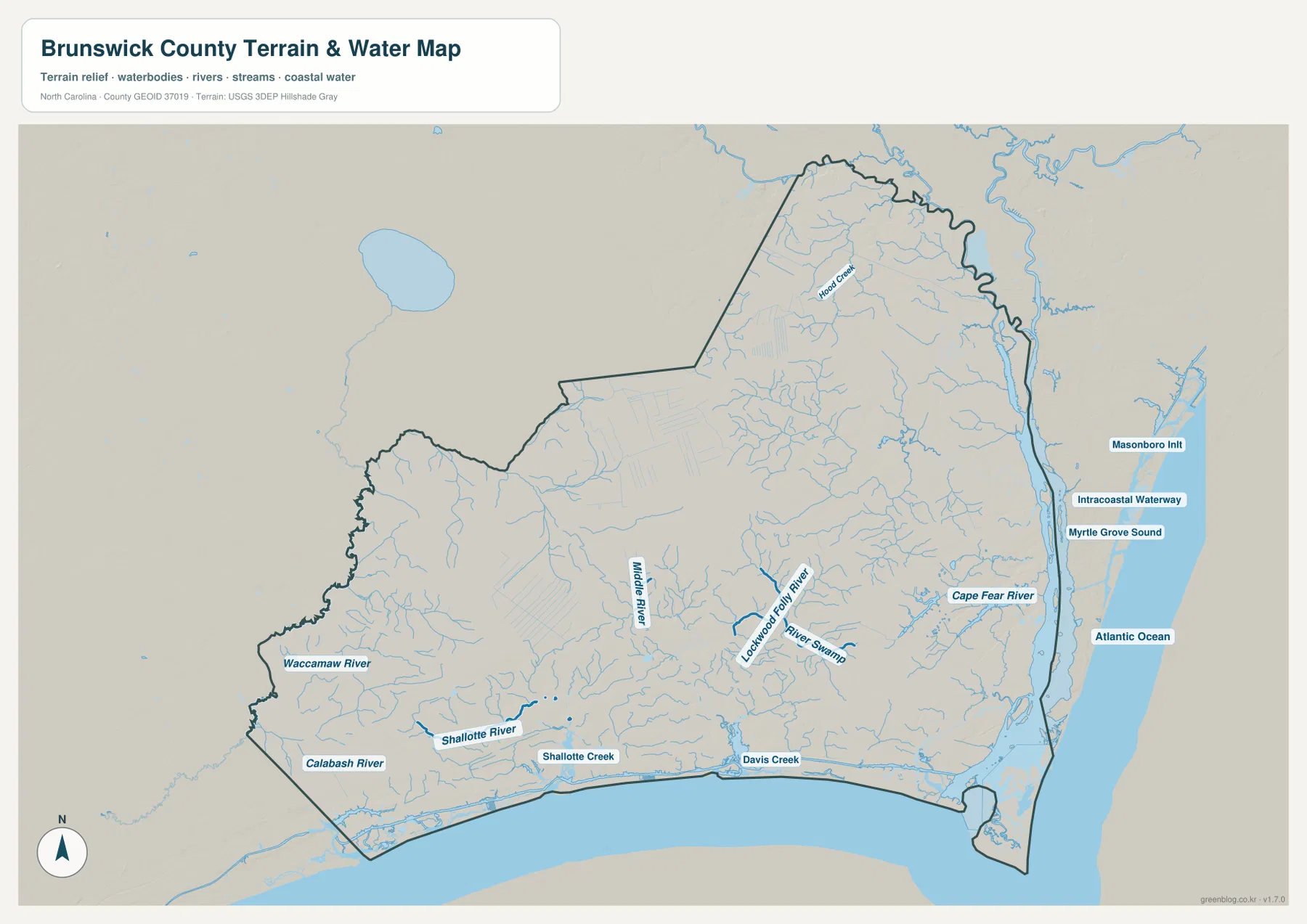
Comparing this water map with the settlement map gives coastal place names a clearer physical setting. Southport and Caswell Beach are near the Cape Fear River mouth and the Atlantic side of the county. Oak Island and Holden Beach extend along the southern coast farther west. Shallotte and Calabash are easier to place when Shallotte River and Calabash River are visible, while Leland and Navassa occupy the northeastern side closer to the Cape Fear system. The waterways therefore provide orientation that road numbers alone cannot supply.
This terrain-and-water image is a geographic reference, not a flood-zone, parcel, navigation, or legal-boundary product. It does not provide survey-grade positions, channel depths, property lines, or regulatory determinations. For those purposes, an appropriate official source must be consulted. Here, the value of the map is simpler: it shows where the named rivers, creeks, inland water features, coastal waterway, and ocean sit relative to the county outline and major communities.
The northeastern edge, beach corridor, and southwest are easier to read separately
Taken together, the three maps suggest a practical way to organize Brunswick County without inventing new administrative divisions. The northeastern area is defined by Leland and Navassa near the Wilmington side of the county. The southern and southeastern coast includes Southport, Oak Island, St. James, Caswell Beach, and Bald Head Island, with Cape Fear River and the Atlantic providing obvious natural reference points. The southwestern area is centered more around Shallotte, Carolina Shores, Calabash, and Sunset Beach.
This approach is helpful because each area uses different map clues. Around Leland, the northeastern road network and the county’s position next to New Hanover County matter most. Along the southern shore, Route 211, 133, the barrier-island place names, and the water boundary become more important. In the southwest, Route 17, 130, 904, Shallotte River, and Calabash River create a different set of references. A single phrase such as ‘the Brunswick County coast’ can hide those internal differences.
The basic map also shows green areas and numerous small water lines between the main communities. Even without turning this page into a land-cover analysis, those features explain why the county’s settlement and road pattern is not simply a dense continuous urban strip. Inland spaces, water crossings, and coastal geography separate places that may look close if only the county name is considered. The maps are most informative when the reader moves back and forth between roads, city locations, and water rather than expecting one layer to explain everything.
Choosing the right Brunswick County file for a specific task
For a general county overview, the boundary-and-road map should usually come first. It places Leland, Shallotte, Southport, Oak Island, Calabash, and several beach communities in one frame and lets the reader follow the major numbered roads. This is the most useful version for a school handout, a county-location reference, or a page that needs to explain where major places sit before discussing one particular physical feature.
The city-distribution map is more efficient when the question is where the major labeled communities are concentrated. Because the six indexed places are isolated and ranked, the northeast-south-southwest contrast is easier to see than on the busier base map. The terrain-and-water map should be selected when rivers and the coast are the subject. Cape Fear River, Waccamaw River, Shallotte River, Lockwoods Folly River, the Intracoastal Waterway, and Atlantic Ocean can all be traced without the road labels competing for attention.
The three files are complementary rather than alternate color versions of the same drawing. A presentation can use the county map for orientation, switch to the city map to compare settlement distribution, and then use the water map to explain why the shoreline and inland river system matter. The downloadable archive contains all three A3 high-resolution JPG files, so the larger originals can be used when the web previews are not detailed enough for printing or close inspection.
The images embedded in the article are web previews. Use the ZIP archive when a larger image is needed for a document, classroom material, or close reading of labels. If a project requires legal boundary confirmation, navigation, engineering measurements, flood determination, or another safety-critical use, confirm the relevant information through the responsible official agency rather than relying on these reference maps alone.
Frequently Asked Questions
Why do Leland and Oak Island look like separate parts of Brunswick County on the maps?
Leland sits near the northeastern edge of the county close to the New Hanover County side, while Oak Island stretches along the southern coast. The city-distribution map places them far apart, and the road map shows a broad interior between the two areas. Treating Leland as a northeastern center and Oak Island as part of the southern coastal group makes their positions much easier to understand.
Is Cape Fear River enough to describe Brunswick County’s water geography?
No. Cape Fear River is the largest named river feature on the eastern side, but the supplied map also labels Waccamaw River, Calabash River, Shallotte River, Middle River, Lockwoods Folly River, several creeks, the Intracoastal Waterway, and the Atlantic Ocean. Reading those features together gives a much fuller picture of the county’s inland and coastal water network.
Why is Bolivia important if it is not one of the six places in the city index?
The city map ranks six major labeled communities, so it serves a different purpose from the general county map. The county map marks Brunswick County Courthouse in the south-central interior, providing an administrative reference around Bolivia. The two maps therefore answer different questions: the city view emphasizes the distribution of its indexed communities, while the county view helps locate administration, roads, and other reference points.
Sources and reference data
For official boundary and geographic reference data, see the U.S. Census Bureau TIGER/Line Shapefiles. The USGS National Hydrography provides authoritative water-feature resources. County background and local history are available from the official Brunswick County History of Brunswick County page. The descriptions on this page prioritize place names and features that are directly shown in the supplied maps and package materials.
Map File Information
Download the Brunswick County boundary-and-road map, city-distribution map, and terrain-and-water map as three A3 high-resolution JPG files in one ZIP archive.
- File Type: ZIP archive
Related Maps
Green Map creates custom-edited map images using open geographic data sources such as geoBoundaries, Natural Earth, OpenStreetMap, and government open data. These maps are edited visual materials, not raw data files, and are provided for education, documents, presentations, and graphic reference.