Levy County Map readers can use this page to move between a very different set of landscapes: Bronson and the inland road network, Chiefland and Fanning Springs in the northwest, Williston on the eastern side, Inglis in the south, and Cedar Key on the Gulf coast. The county does not read like a single compact urban area. Towns are separated by long rural stretches, while the western and southern edges become increasingly shaped by rivers, creeks, marshy shorelines, passes, and islands.
The page includes a county reference map, a ranked city-location map, and a water map focused on rivers and coastal channels. If you need larger files after reviewing the web images, the download box below provides a ZIP containing three high-resolution A3 JPG maps. They are useful for printing, study, presentations, and general location reference, but they are not substitutes for legal boundary surveys, navigation charts, flood maps, or live traffic information.
Table of Contents
From Bronson’s inland crossroads to Cedar Key on the Gulf
Bronson provides a practical starting point for reading Levy County because it sits near the middle of the county’s inland road pattern. Chiefland and Fanning Springs are northwest of Bronson, Williston is to the east, and Cedar Key lies far to the southwest on the coast. Inglis and Yankeetown form another southern area near the county boundary. Seeing those places together makes it clear that trips across Levy County often change direction rather than following one continuous urban corridor.
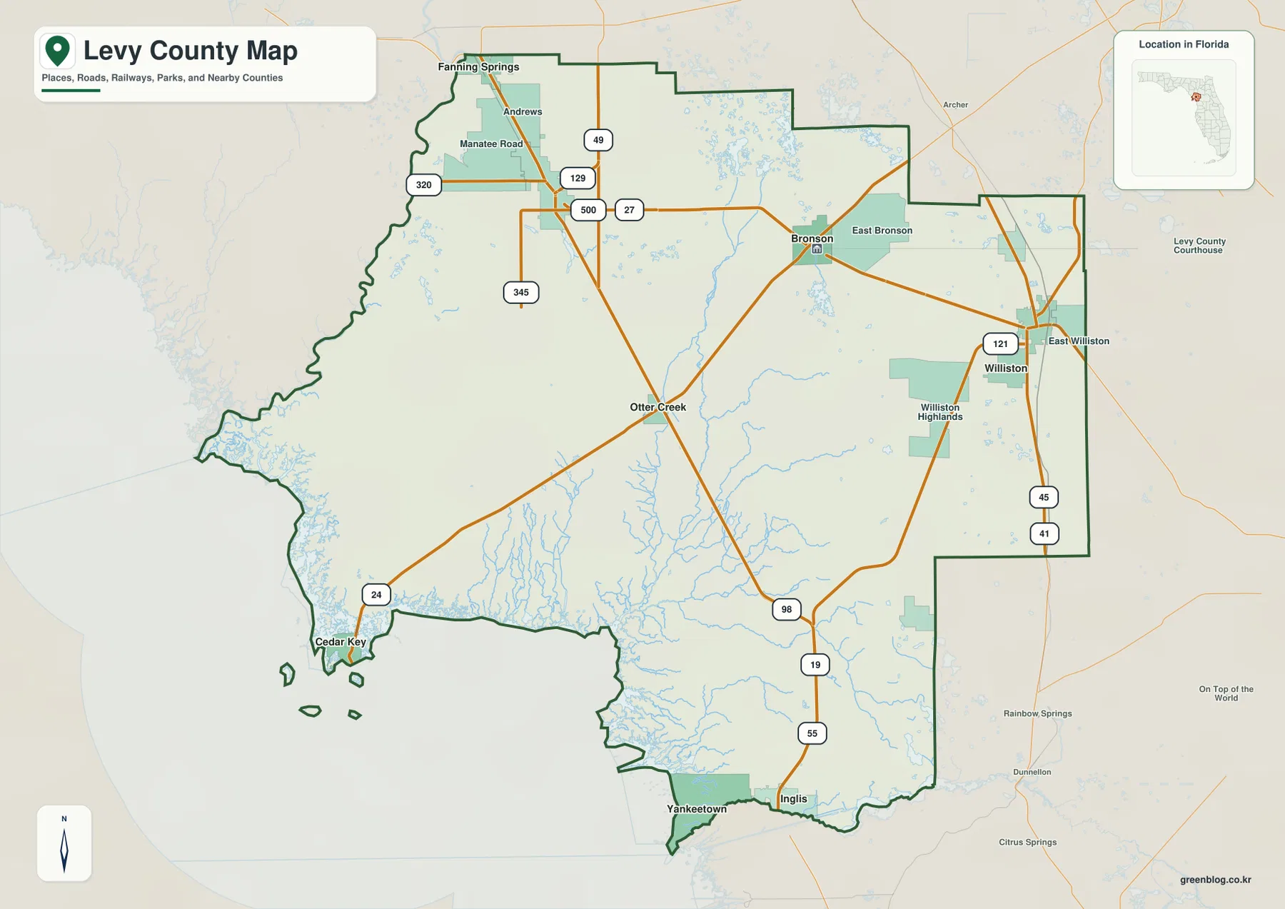
The road pattern helps explain those relationships. U.S. 19/98 runs through the western interior, while the 27/500 corridor crosses the central part of the county between the Chiefland area, Bronson, and Williston. U.S. 41 appears along the eastern side near Williston, and Route 24 turns southwest from the interior toward Cedar Key. The supplied map does not show an Interstate crossing the county, so numbered U.S. and state routes do most of the work of connecting the separated inland and coastal communities.
Smaller labels add useful detail between the better-known towns. Otter Creek lies along the western interior route, East Bronson and East Williston help orient the central and eastern sides, and Williston Highlands appears south of Williston. Andrews and Manatee Road are labeled farther northwest. These places matter on a county-scale map because long gaps between larger town names can otherwise make the interior look emptier and less connected than it actually is.
Six mapped communities spread across very different parts of the county
The city map simplifies the county by ranking six major mapped communities and removing much of the road and water detail. The supplied index lists Williston first, Chiefland second, Inglis third, Bronson fourth, Fanning Springs fifth, and Cedar Key sixth. The ranking is less important for orientation than the geography: Williston is separated on the east, Chiefland and Fanning Springs sit in the northwest, Bronson is central, Inglis is near the south, and Cedar Key occupies the southwestern coast.
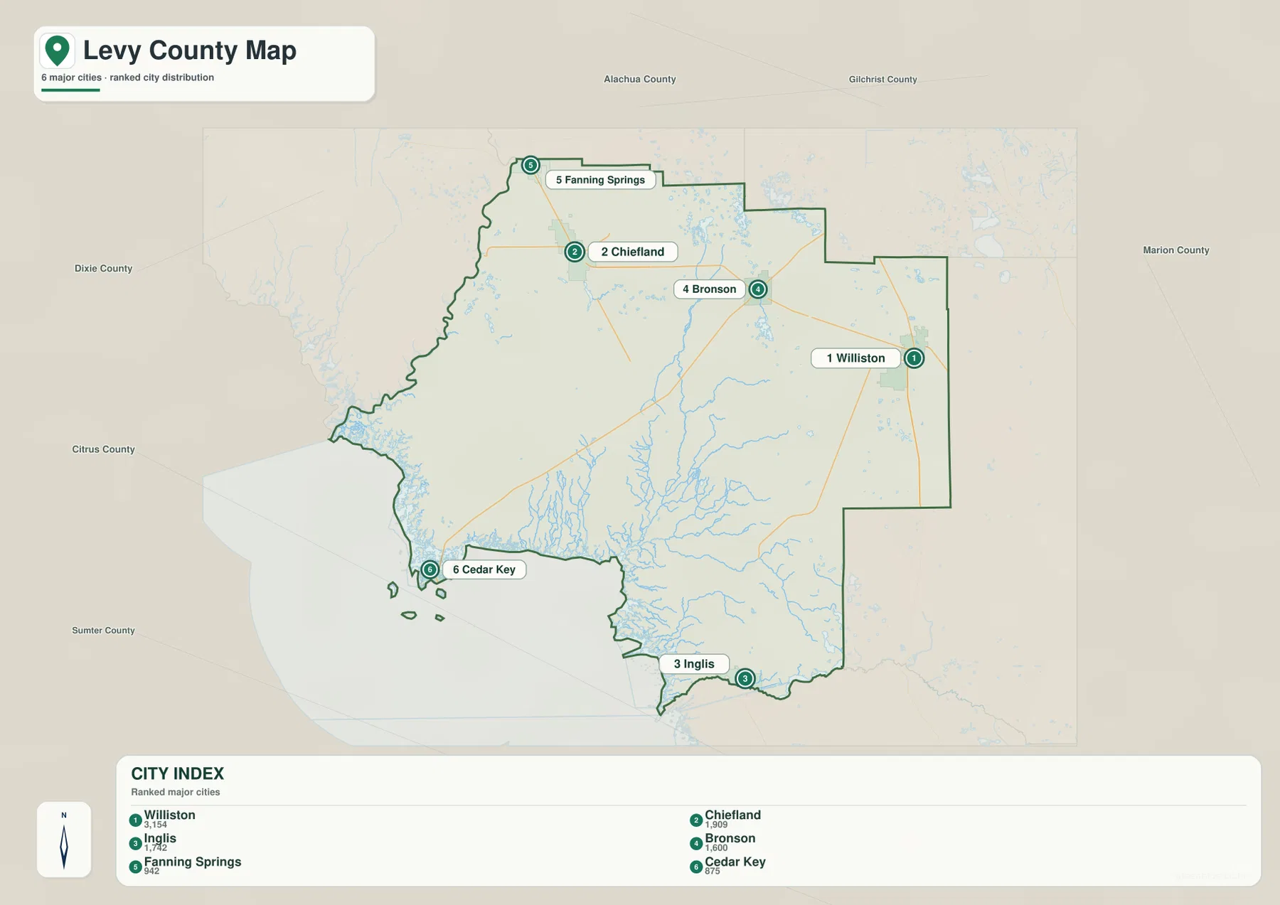
That spread is useful when deciding which place should serve as a reference point. Williston works well for the eastern side near U.S. 41, while Chiefland is a better anchor for the northwestern road network. Bronson helps connect the central routes, and Inglis is the more useful reference for the southern boundary. Cedar Key should be treated separately from the inland towns because its access follows a coast-bound route rather than a direct north-south road through the county.
The city-map numbers should not be read as a travel sequence or as straight-line connection distances. They are part of the ranked city index shown on the supplied map. For route planning, switch back to the county reference map and follow the numbered roads. This is especially important for Cedar Key, where water and wetlands limit the number of practical overland approaches even though the town may look close to other places when viewed without road detail.
Waccasassa River, smaller creeks, and a fragmented Gulf shoreline
The water map changes the emphasis completely. The Waccasassa River is one of the strongest labeled features, running through the south-central part of the county toward the Gulf. Little Waccasassa River appears farther north, while Cow Creek and Tenmile Creek add smaller branches to the drainage network. Instead of a simple coastline, the western and southern edges show many narrow channels and wetland-like water features extending inland from the Gulf.
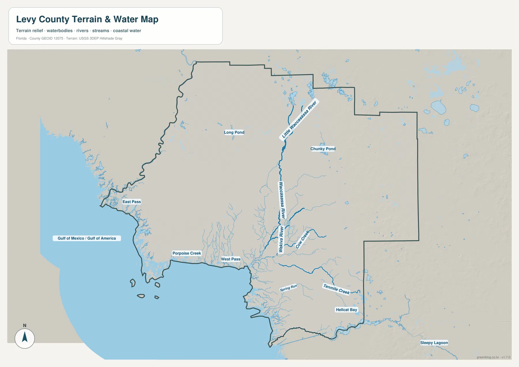
Several smaller labels help show how intricate the coastal side becomes. East Pass and West Pass are marked near the western shoreline, Hellcat Bay appears farther south, and inland water bodies such as Long Pond and Chunky Pond are also visible. These names are useful because they show that the county’s western edge is not one uninterrupted beach line. Islands, tidal channels, river mouths, and low coastal water areas break the shore into many separate pieces.
This map is designed for general water-feature reference. It does not show flood probability, tidal height, safe boating depth, parcel ownership, or a legal shoreline. A creek drawn on the map should therefore be read as a geographic reference rather than proof that a route is navigable or that land beside it is publicly accessible. For those decisions, use current information from the appropriate state, federal, or local agency.
Frequently Asked Questions
Why does Cedar Key appear isolated from the inland towns?
Cedar Key occupies Levy County’s southwestern island coast and is reached from the interior along SR 24. Bronson connects directly to that road, but there is no straight shoreline highway from Chiefland or Williston. Tidal marsh and the Waccasassa Bay drainage fill much of the intervening coast, so the road distance is substantially different from the short visual gap across open map space.
Where is the Suwannee River estuary?
The estuary is at Levy County’s northwestern corner along the boundary with Dixie County. It is west to northwest of Chiefland and north of Cedar Key. Lower Suwannee National Wildlife Refuge occupies extensive land around the lower river, which accounts for the limited road network and lack of large settlements near the mapped river mouth.
Why does Cedar Key look separated from Levy County’s inland towns?
Cedar Key sits on the southwestern Gulf coast, while Bronson, Chiefland, and Williston are inland. The county map shows Route 24 leading toward Cedar Key from the interior, and the water map shows a much more fragmented coastal landscape around that side of the county. Reading the road and water maps together explains the separation better than straight-line distance alone.
Do the numbers on the city map show a recommended driving order?
No. The numbers belong to the ranked city index on the supplied map. They identify Williston, Chiefland, Inglis, Bronson, Fanning Springs, and Cedar Key in that order, but they do not trace a route. Use the county reference map when you need to follow actual roads between those places.
Which water feature is most prominent on the Levy County water map?
The Waccasassa River is one of the clearest labeled river features in the south-central part of the map. Little Waccasassa River, Cow Creek, Tenmile Creek, several ponds, and the coastal passes add detail around it. The map is useful for locating these features, but it does not provide flood levels, channel depths, or navigation guidance.
Map File Information
Download the map files associated with this page for reference, printing, and compatible visual projects.
- Included Files: 3 high-resolution A3 JPG map files shown in this article
- File Type: JPG files in a ZIP archive
- Intended Use: Printing, education, presentations, and map-based projects
Related Maps
- Arcadia Roads and Peace River | DeSoto County Florida Map
- Baker County Florida Map
- Blountstown, SR 20, and the Apalachicola River | Calhoun County Florida Map
Sources and References
- Levy County Government
- Florida Department of Transportation — County General Highway Maps
- U.S. Fish and Wildlife Service — Lower Suwannee National Wildlife Refuge
- U.S. Fish and Wildlife Service — Cedar Keys National Wildlife Refuge
- U.S. Census Bureau QuickFacts — Levy County
Green Map creates custom-edited map images using open geographic data sources such as geoBoundaries, Natural Earth, OpenStreetMap, and government open data. These maps are edited visual materials, not raw data files, and are provided for education, documents, presentations, and graphic reference.