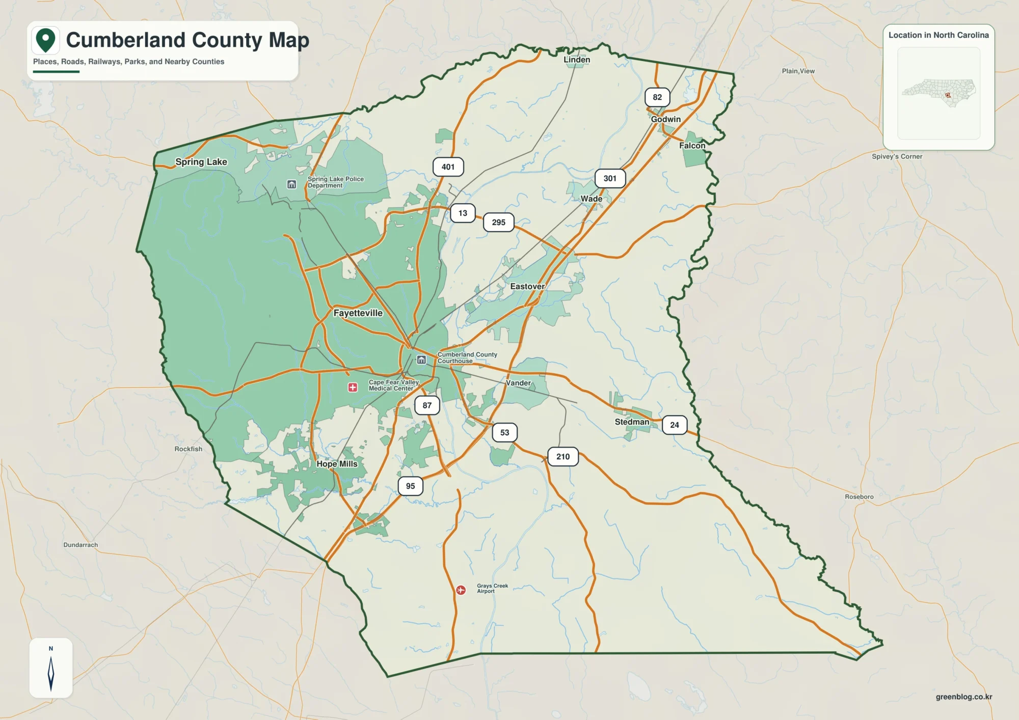
Troup County sits on Georgia’s western side, with LaGrange near the center, West Point at the southwest edge by the Alabama line, and Hogansville to the northeast. Those three places give the county map a clear shape: LaGrange is the main hub, West Point is tied closely to the Chattahoochee River and West Point Lake, and Hogansville lies near the Interstate 85 corridor. The four maps on this page separate those themes so you can compare boundaries and roads, city positions, waterways, and elevation without forcing everything into one crowded image. A ZIP containing four high-resolution A3 JPG files is available in the map file box below.
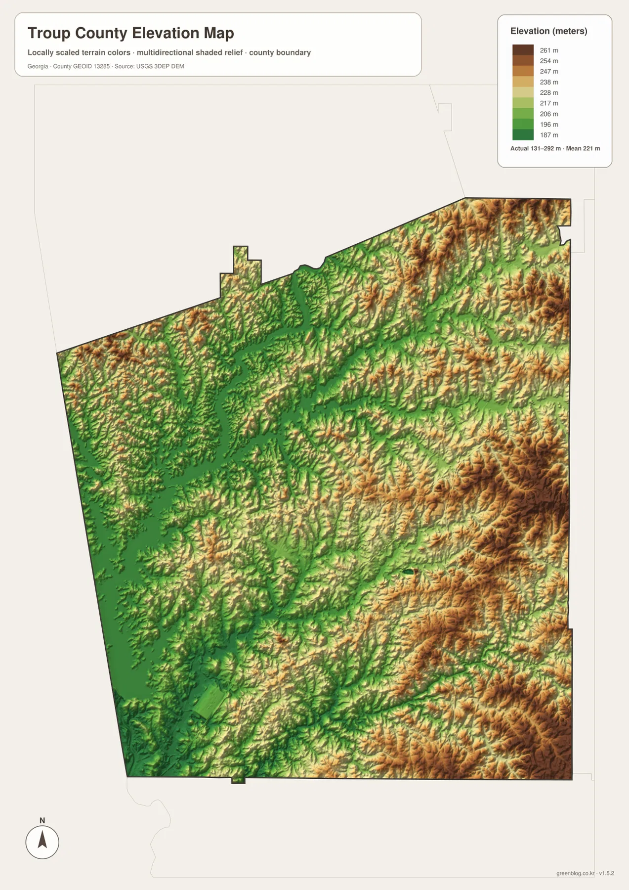
The strongest geographic contrast is between the broad lake-and-river corridor on the west and the more closely spaced ridges on the eastern side of the county. West Point Lake fills a large part of the western map area with long coves and branching shorelines, while the elevation surface becomes rougher and higher toward the east and southeast. Reading the maps together makes it easier to connect the location of towns and roads with the physical landscape behind them.
Table of Contents
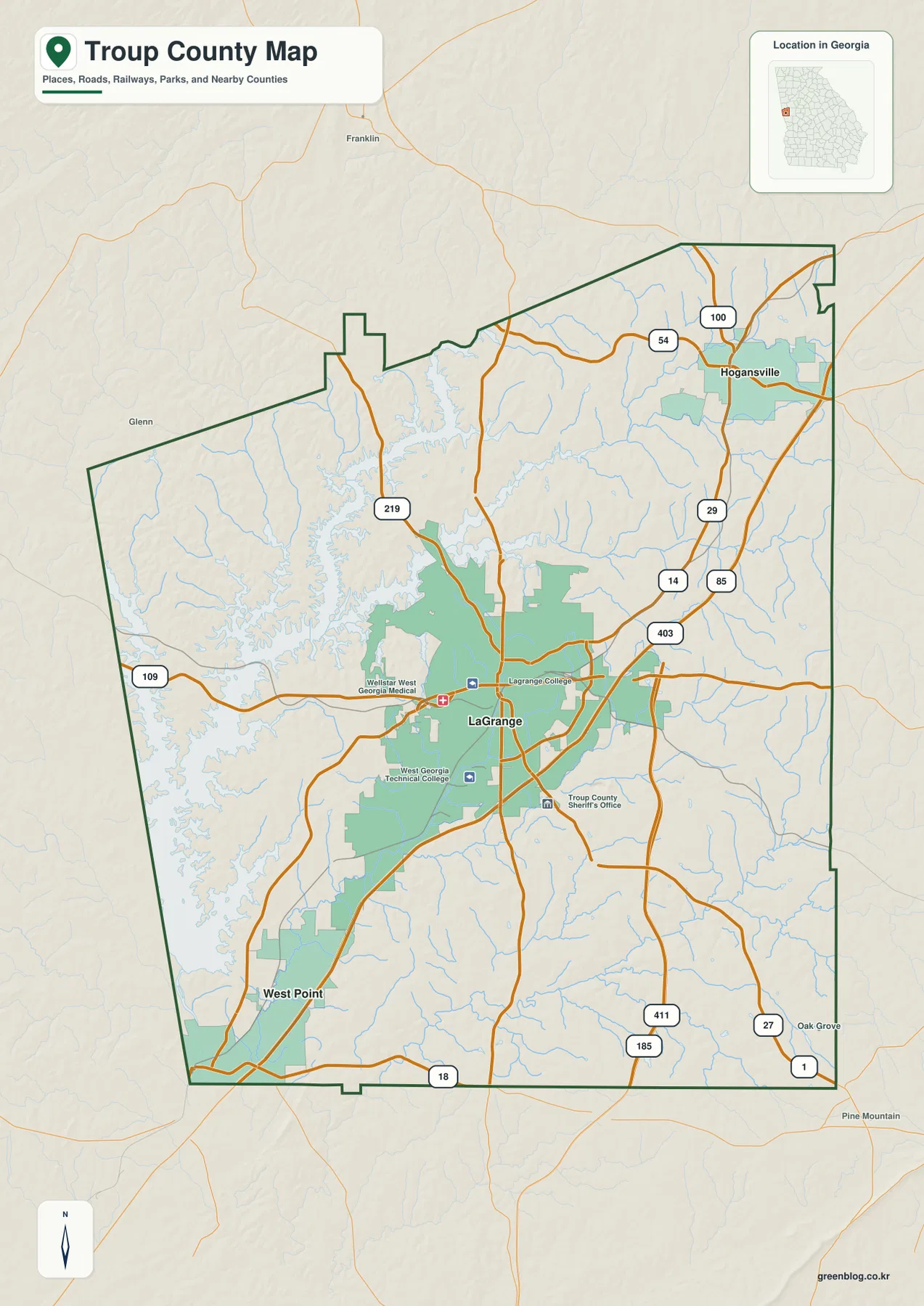
LaGrange, Major Roads, and the Shape of Troup County
On the general county map, LaGrange stands out as the central urban area. Several major roads converge around the city, while Interstate 85 runs along the eastern side of the LaGrange area and continues north toward Hogansville. Route 109 reaches west toward the lake side of the county, and Route 219 provides another north–south connection west of the main interstate corridor. Along the southern edge, Route 18 helps show how the southwest and southeast parts of the county connect to the wider road network.
The map also makes the western side of Troup County look very different from the east. Large arms of West Point Lake reach into the county from the Chattahoochee River system, so the boundary area is broken up by water rather than appearing as a simple straight edge. West Point sits near the southwest corner where the lake-and-river landscape meets the Alabama border. LaGrange, by contrast, is inland and surrounded by a denser road pattern, which is useful when you need a quick orientation to the county before looking at the more specialized city, water, or elevation maps.
Selected local landmarks around LaGrange are included as orientation points, but this is not a parcel map or a complete street directory. Smaller roads, property lines, every unincorporated community, and legal municipal boundaries require more detailed sources. For a county-wide overview, however, the combination of the outer boundary, main cities, major road labels, water features, and nearby context gives a practical first view of the area.
How LaGrange, West Point, and Hogansville Relate to One Another
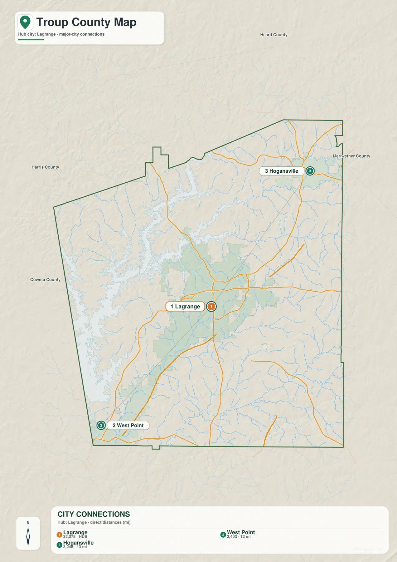
The city-connections map reduces the county to its three most prominent labeled cities and uses LaGrange as the hub. West Point is southwest of LaGrange near the county corner, while Hogansville is northeast of the hub. The map labels a straight-line distance of about 12 miles from LaGrange to West Point and about 13 miles from LaGrange to Hogansville. These are direct point-to-point distances, not driving distances, so they should not be used as a substitute for a route planner.
The population labels on the city map also make the difference in city scale easy to see: LaGrange is shown at 32,078, West Point at 3,403, and Hogansville at 3,246. The exact purpose of those numbers here is comparison rather than a live population count. They reinforce what the road map already suggests—LaGrange is by far the largest urban center, while West Point and Hogansville anchor different ends of the county.
That arrangement matters when describing Troup County because the three cities are not clustered together. A visitor moving from West Point to Hogansville would cross the county through or near the LaGrange area, while the map’s road lines show that the northeastern side has stronger contact with the I-85 corridor. In classroom work or a regional overview, this city map is useful for explaining direction and relative spacing without the extra detail of small streams and local streets.
The Chattahoochee River, West Point Lake, and Troup County Creeks
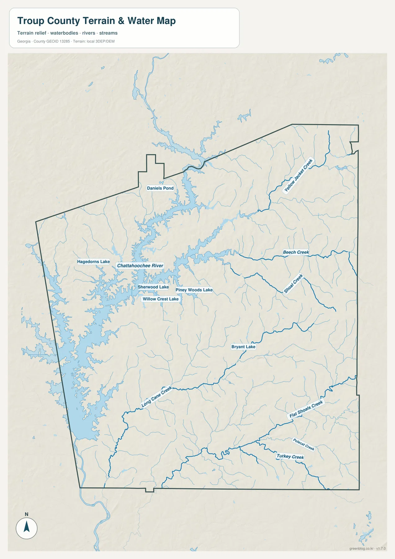
Water dominates the western side of the terrain-and-water map. The Chattahoochee River and West Point Lake form a broad, branching system with long coves that extend well into the county. Near the southwest corner, the open reservoir narrows back toward the river at West Point. Farther north, the lake spreads into multiple arms, making the western landscape much more water-cut than the eastern half of Troup County.
Several named creeks help explain how the rest of the county drains toward larger channels. Yellow Jacket Creek is labeled in the northeast, while Beech Creek and Shoal Creek cross the central-east side. Long Cane Creek runs across the southern half toward the west, and Flat Shoals Creek, Turkey Creek, and Polecat Creek appear farther south and southeast. These streams occupy narrow valleys that are easier to recognize when the water map is compared with the elevation image.
The map also marks smaller water bodies, including Daniels Pond, Hagedorns Lake, Sherwood Lake, Willow Crest Lake, Piney Woods Lake, and Bryant Lake. Their sizes are modest compared with West Point Lake, but including them helps distinguish the county’s many local ponds and lakes from the main Chattahoochee reservoir system. The water map is best treated as a geographic reference: it does not show flood zones, water depth, navigation channels, parcel ownership, or legal shoreline boundaries.
From the Low Lake Corridor to the Higher Eastern Ridges
The elevation map adds another layer to the west–east contrast. Its annotation gives an actual elevation range of about 131 to 292 meters, with a mean near 221 meters. Darker green areas follow the lower western lake and river corridor, while tan and brown ridges become more common toward the east. The southeast in particular shows a dense pattern of higher ridges separated by narrow valleys.
This surface also helps explain why the stream network branches the way it does. Creeks occupy the lower cuts between ridges, then work westward or northwestward toward the larger Chattahoochee system. Around West Point Lake, the broad low corridor is easy to trace because the reservoir occupies the same western depression that appears green on the elevation map. LaGrange lies between the lake lowlands and the more strongly dissected hills farther east, giving the central part of the county a transitional appearance.
The elevation image is designed for county-scale comparison, not site engineering. It is appropriate for seeing where the county is generally lower or higher and for connecting ridges with valleys and waterways. It should not be used to determine the precise elevation of a house, road shoulder, construction site, or property corner; those tasks require survey-grade or official site-specific data.
What Becomes Clear When the Four Maps Are Compared
Each map is most useful for a different question. The county reference map is the fastest choice for the boundary, major roads, and the location of LaGrange. The city map strips away extra detail and makes the southwest–center–northeast relationship between West Point, LaGrange, and Hogansville easy to explain. The water map is the better choice for naming creeks, following the Chattahoochee River, or showing the irregular edge of West Point Lake. The elevation map is the clearest way to compare the low western corridor with the more rugged eastern half.
The maps become more informative when used as a set. West Point’s position on the city map lines up with the river-and-lake system in the southwest. Hogansville’s position in the northeast aligns with the road corridor that continues along the eastern side of the county. The lower western elevations correspond with the reservoir and river, while the higher eastern ridges help explain the many smaller valleys and creek branches there. These relationships are easy to miss if you only look at a list of place names.
| County hub | LaGrange |
|---|---|
| Other labeled cities | West Point and Hogansville |
| Major water feature | Chattahoochee River and West Point Lake |
| City-map distances | LaGrange–West Point about 12 mi; LaGrange–Hogansville about 13 mi, straight line |
| Elevation-map range | Actual about 131–292 m; mean about 221 m |
| Download set | Four high-resolution A3 JPG maps in one ZIP |
Using the Maps for Classes, Local Research, and Print
For a geography lesson, a good sequence is to begin with the county map, find LaGrange, then locate West Point and Hogansville on opposite sides of the hub. The water map can follow by showing how strongly the western side is shaped by West Point Lake and the Chattahoochee River. Adding the elevation map last gives students a visual reason for the difference between the broad western water corridor and the closely spaced hills to the east.
For a local-history article or presentation, the same maps can be used selectively. A paragraph about transportation can use the road and city maps, while a section on outdoor recreation or the physical setting can use the lake, creek, and elevation images. The map set is also useful as an orientation aid for genealogy or regional research because it gives the reader a county-wide frame before they move to detailed street, parcel, cemetery, or historical maps.
The WEBP images in the article are optimized as page previews. For printing or for inserting a larger map into a document, use the A3 JPG files in the ZIP. The archive contains the county map, city-connections map, water map, and elevation map as separate files, so you can download the set once and then choose the image that fits the project.
Frequently Asked Questions
Where does West Point Lake appear on the Troup County maps?
West Point Lake occupies a large part of the western side of the county. The water map shows its branching coves and connection to the Chattahoochee River most clearly, while the county map helps place the lake in relation to LaGrange and West Point.
How far are West Point and Hogansville from LaGrange on the city map?
The city map labels West Point at about 12 miles from LaGrange and Hogansville at about 13 miles. Those measurements are straight-line distances between the mapped city points, not road mileage or estimated driving time.
Can the elevation map be used for a property or construction survey?
No. It is a county-scale reference intended to show broad terrain differences, such as the lower western lake corridor and the higher eastern ridges. Precise site elevations should come from official site-specific data or a professional survey.
Sources and Reference Data
The following official and established sources are useful for county background and for the boundary, water, and elevation data behind this type of map.
- U.S. Census Bureau QuickFacts for Troup County
- Troup County Government history page
- New Georgia Encyclopedia: Troup County
- USGS National Hydrography
- USGS 3D Elevation Program
Map File Information
The ZIP includes four high-resolution A3 JPG maps of Troup County: county, city, water, and elevation versions.
- Included Files: Four map versions: county, city, water, and elevation
- File Type: High-resolution A3 JPG files in a ZIP archive
- Intended Use: Printing, education, presentations, and map-based projects
Related Maps
Green Map creates custom-edited map images using open geographic data sources such as geoBoundaries, Natural Earth, OpenStreetMap, and government open data. These maps are edited visual materials, not raw data files, and are provided for education, documents, presentations, and graphic reference.