Jefferson County stretches north to south across east-central Georgia, from Wrens, Stapleton, and Avera in the upper part of the county to Wadley and Bartow near the south. Louisville, the county seat, sits below the geographic middle and works well as the main orientation point. The maps on this page show the county boundary, major roads, six incorporated places, the upper Ogeechee River and named creeks, and elevation changes between higher northern ground and lower stream valleys. You can download all four maps as high-resolution A3 JPG files in one ZIP for printing, presentations, classroom work, or offline reference.
A useful way to read the county is to start at Louisville and then look north toward Wrens or south toward Wadley and Bartow. Stapleton and Avera sit west of Wrens, while the road network ties these northern places to Louisville and the southern communities. The water and elevation views then explain another part of the landscape: many creeks occupy lower corridors, and the broad pattern shifts from higher terrain in the north and northwest toward lower ground in the central and southern parts of the county.
Table of Contents
Roads, boundaries, and the route through Louisville
The general county map provides the broadest reference view. Washington County lies along much of the western side, Glascock County is to the northwest, and Burke County borders Jefferson County on the east. Johnson and Emanuel counties are near the southwest and south, while labels such as Gibson, Keysville, Davisboro, and Midville appear beyond the county line. Those outside place names are useful because they show where the road network continues after a traveler leaves Jefferson County.
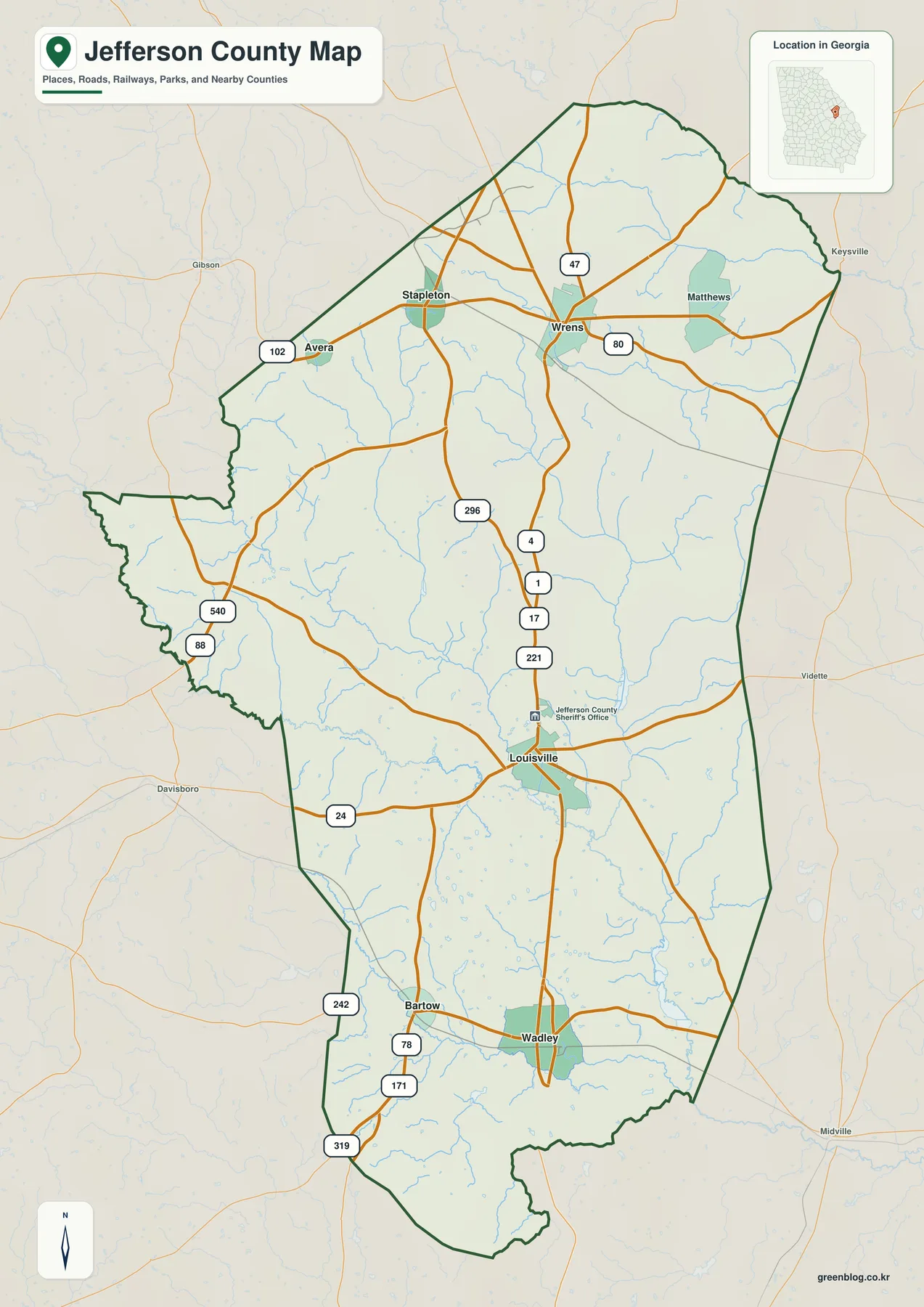
Louisville and Wrens are the clearest road anchors. U.S. 1 and U.S. 221 pass through the Louisville area and continue north, while U.S. 80 runs east-west through Wrens. Other numbered routes branch toward Stapleton and Avera in the northwest and toward Wadley and Bartow in the south. With those routes in view, it becomes easier to understand which towns share a travel direction and which side of the county a road reaches before crossing into a neighboring county.
This is a regional reference map rather than a turn-by-turn navigation product. It does not attempt to include every residential street, driveway, parcel line, temporary closure, or construction detour. For school projects, local-history research, and trip planning at the county scale, however, the combination of boundary, towns, and numbered roads gives a clear picture without the clutter of a live street map.
From Wrens to Wadley: where Jefferson County’s main communities sit
The city map simplifies the road detail and highlights six incorporated places: Wrens, Louisville, Wadley, Stapleton, Avera, and Bartow. Their distribution is uneven. Wrens, Stapleton, and Avera form a northern group, Louisville stands farther south by itself, and Wadley and Bartow sit closer together in the southern road network. Seeing those locations on one page makes the county’s long north-south shape much easier to understand than a list of town names alone.
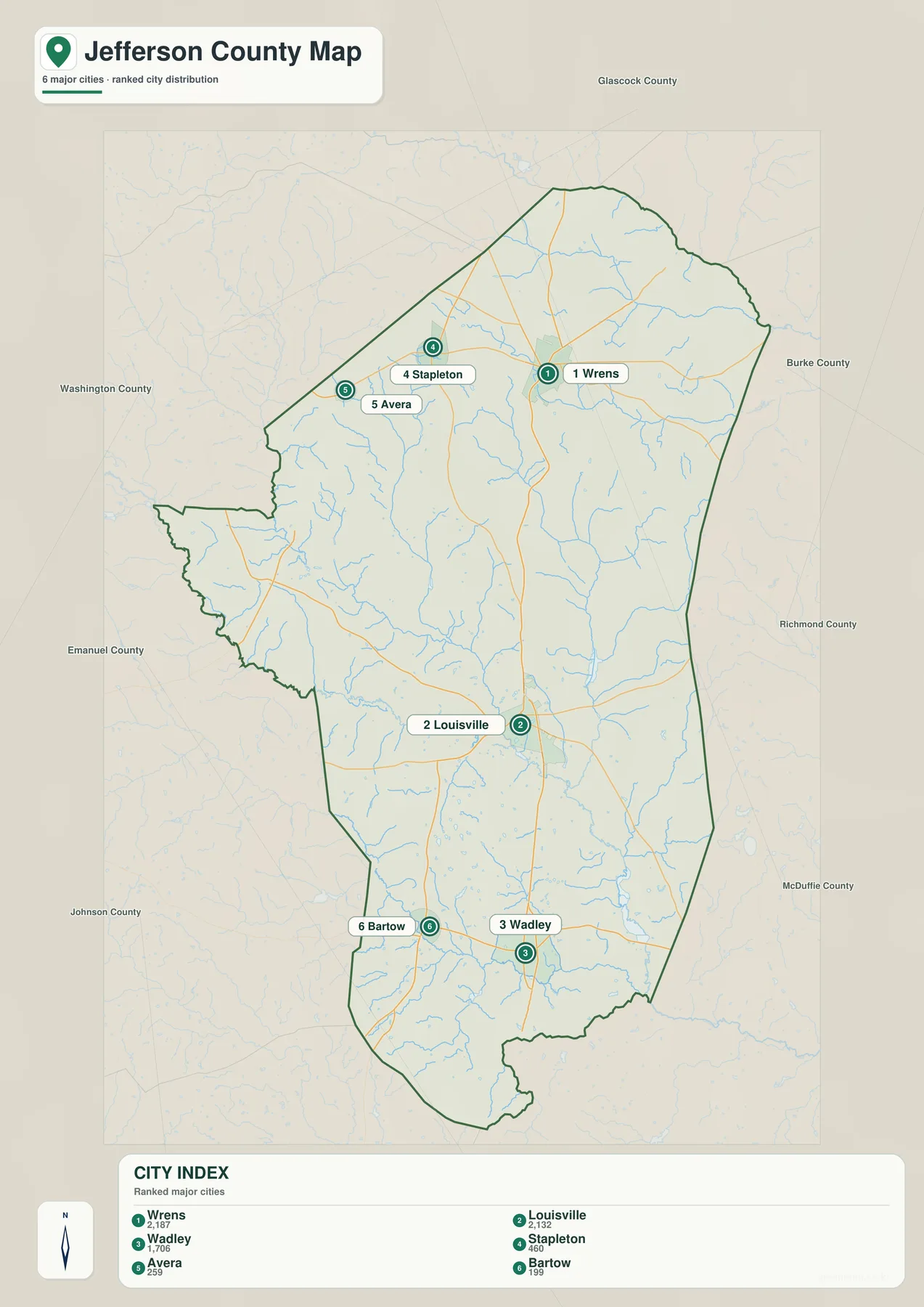
The index numbers are mainly lookup aids; the positions matter more. Wrens is close to the northeastern road junctions, Stapleton and Avera lie to its west, and Louisville is the administrative center in the central-southern part of the county. Wadley and Bartow provide two easy reference points farther south. Together, those six communities help readers follow local news, family records, school materials, or historical accounts without having to locate every crossroads and unincorporated settlement.
Louisville has added importance because it is the county seat, so courthouse and county-government references point there. Wrens is the most useful northern reference on the map, while Wadley and Bartow quickly identify the southern section. The map is intentionally selective, which keeps the geographic relationship between the best-known communities clear instead of filling the page with minor place labels.
Upper Ogeechee headwaters, creeks, ponds, and small lakes
Jefferson County’s water features are spread through a network of creeks and smaller impoundments rather than concentrated around one dominant lake. The most important feature is the upper Ogeechee River. Historical U.S. Geological Survey descriptions identify the meeting of Rocky Comfort Creek and Williamson Swamp Creek as the beginning of the Ogeechee River, placing the county directly at the headwaters of a major eastern Georgia river system. On the map, those channels come together in the central-southern part of the county before the river continues downstream.
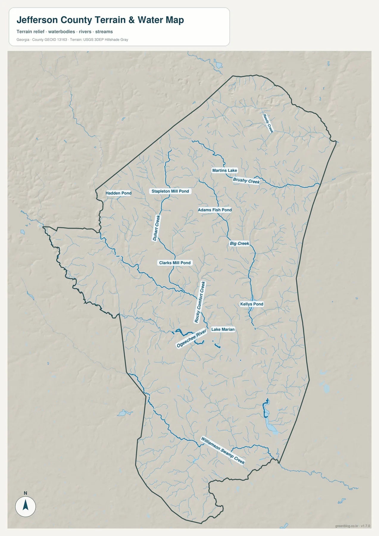
Several other names give the map useful local detail. Reedy Creek and Brushy Creek cross the north and northeast, Duhart Creek runs through the western-central area, and Big Creek forms a noticeable north-south channel east of Louisville. Hadden Pond, Stapleton Mill Pond, Martins Lake, Adams Fish Pond, Clarks Mill Pond, Kellys Pond, and Lake Marion also appear. The result is a landscape where many small waterways are distributed across the county rather than gathered around a single large reservoir.
The water map is meant for geographic reference, not flood-hazard decisions. A mapped blue line shows a river, creek, or other water feature, but it does not show regulatory floodplain limits, expected flood depth, current water level, or whether a particular road will be passable during a storm. FEMA and local-government sources should be used for those questions. For ordinary map reading, this view is best for finding a named creek and seeing how it relates to Louisville, the southern towns, and the county boundary.
Higher northern uplands and lower stream valleys toward the south
The elevation map adds terrain to the same county outline. It reports an actual range of about 56 to 160 meters, with a mean near 101 meters. Browns and tans cover much of the north and northwest, while greener lower ground follows creek valleys through the middle and becomes more extensive toward the south. Jefferson County is not mountainous, but the contrast between uplands and stream corridors is visible enough to explain why different parts of the county feel slightly higher or lower.
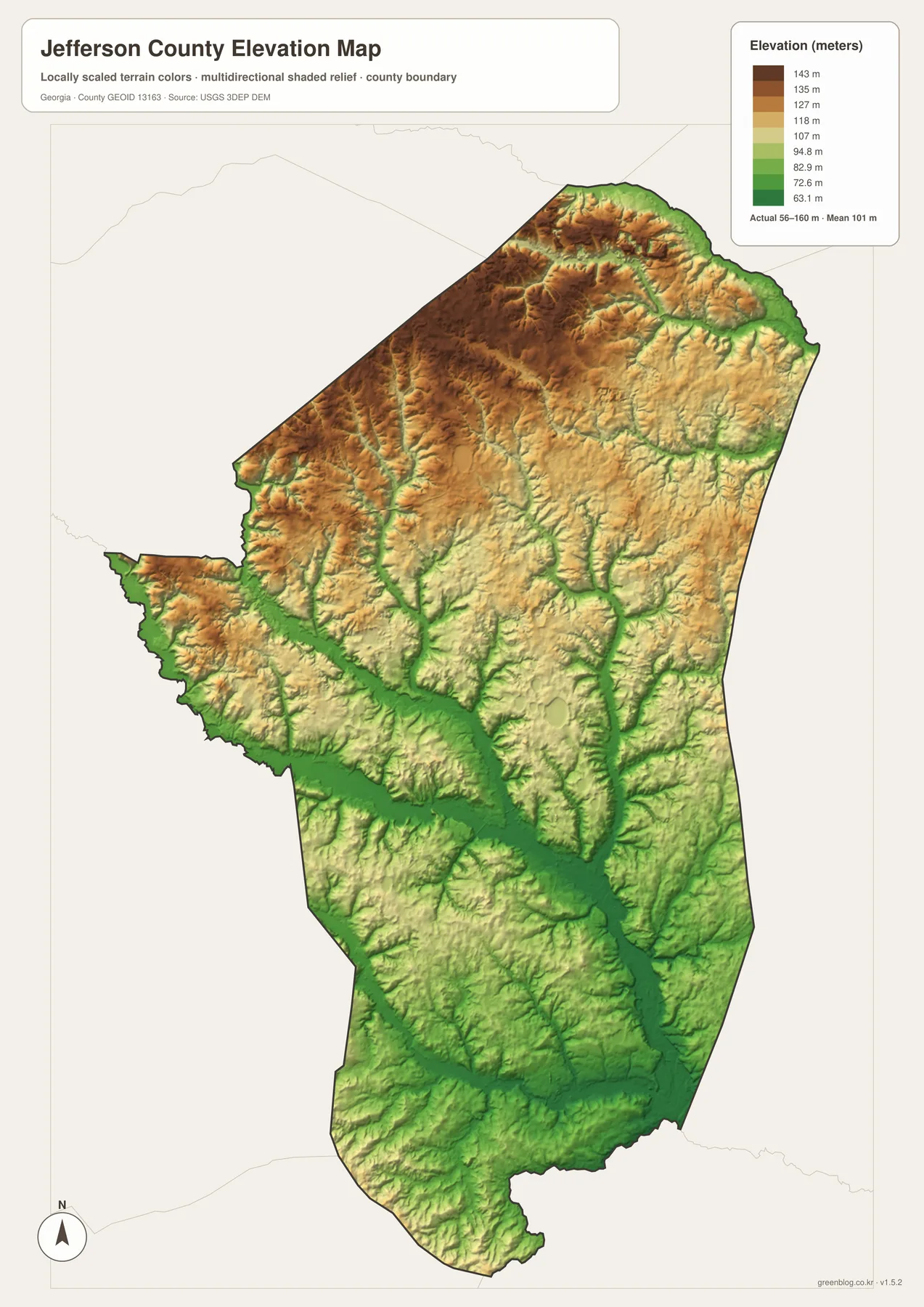
The narrow green branches that reach into higher northern terrain correspond with many of the creeks shown on the water map. Farther south, the lower corridor around Rocky Comfort Creek and the Ogeechee River becomes broader. Looking at the water and elevation maps together makes the relationship easy to follow: one view provides the creek names, while the other shows the lower valleys those channels occupy.
These elevation values are appropriate for county-scale comparison, classroom use, and general geographic description. They should not be treated as surveyed heights for a house site, drainage project, road design, or other engineering work. For those tasks, the original elevation data and professional site measurements are needed. For most readers, the important pattern is simply that higher ground is more common in the north and northwest, while lower terrain becomes more widespread along central and southern drainage corridors.
Louisville’s former capital role and Wadley’s railroad story
The place names on the maps also connect with Jefferson County’s history. The county was created in 1796 from parts of Burke and Warren counties and was named for Thomas Jefferson. Louisville, today’s county seat, once served as Georgia’s state capital. Jefferson County’s official history describes Louisville as the state’s third capital and notes that the first permanent state-capital building was established there.
That background gives Louisville a larger role than its position on a modern county map might suggest. Older political, courthouse, and government references tied to Louisville can be placed within the present county using the general map, while the city map shows its relationship to Wrens, Wadley, and the other incorporated places. Because Louisville remains the county seat, the same name appears naturally in both historical research and current county business.
Wadley has a different transportation history. The county’s official profile says the community was once called Shakerag and was renamed in the 1870s for the president of the Central of Georgia Railway, becoming an official railroad stop during that period. Locating Wadley near the southern part of the county, with Bartow nearby and Louisville farther north, helps connect that historical note to the present-day road and settlement pattern.
Choose the map that matches what you need to find
For a first look at Jefferson County, the general map is the best starting point because it combines the boundary, major roads, and familiar place names. The city map is cleaner when the goal is simply to locate Wrens, Louisville, Wadley, Stapleton, Avera, and Bartow. A project about the Ogeechee River, creeks, ponds, or natural features is better served by the water map, while the elevation map is the clearest choice for explaining the higher northern uplands and lower central and southern valleys.
| General county map | Best for the county boundary, Louisville, Wrens, Wadley, major highways, and surrounding place names. |
|---|---|
| City map | Best for quickly locating Wrens, Louisville, Wadley, Stapleton, Avera, and Bartow. |
| Water map | Best for the upper Ogeechee River, Rocky Comfort Creek, Big Creek, other named tributaries, ponds, and lakes. |
| Elevation map | Best for the roughly 56–160 meter elevation range, higher northern uplands, and lower stream valleys. |
A classroom presentation can begin with the general map and add only the specialized view that supports the topic. A local-history project may use the city map to locate Louisville or Wadley before consulting older records, while a natural-resources discussion can pair the water and elevation maps to show how creeks occupy lower valleys. The WEBP images in the article are lightweight previews; the downloadable package below contains the four larger A3 JPG files for printing, presentations, and offline use.
These are general reference products rather than legal, engineering, flood, or live-navigation maps. Property boundaries, current road conditions, flood decisions, and site-specific elevation work require the responsible official source. Keeping that distinction in mind makes it easier to use each map for the task it was designed to support without expecting one image to answer every geographic question.
Frequently Asked Questions
Which map should I use to find Louisville and Wrens with the main roads?
Use the general county map. It places Louisville and Wrens together with Wadley, Stapleton, Avera, Bartow, the county boundary, and the major numbered roads. If you only need a cleaner comparison of town locations, follow it with the city map.
Does the water map show official flood-risk areas?
No. It shows mapped rivers, creeks, ponds, and lakes, including the Ogeechee River and Rocky Comfort Creek, but it does not show regulatory flood zones, expected flood depth, or current water levels. Flood, property, and insurance decisions require current official hazard information.
What elevation range appears on the Jefferson County map?
The elevation map gives an actual range of about 56 to 160 meters and a mean near 101 meters. Higher ground is more common in the north and northwest, while lower land follows stream valleys and becomes more widespread toward the south. These values are intended for county-scale reference rather than site surveying.
Which files are included in the downloadable ZIP?
The ZIP contains four high-resolution A3 JPG files: the general county map, city map, water map, and elevation map. The article uses WEBP previews for faster browsing, while the JPG versions are intended for printing, presentations, and other offline uses.
Map File Information
Download the general county, city, water, and elevation maps together as four high-resolution A3 JPG files.
- Included Files: General county map, city map, water map, elevation map
- File Type: ZIP containing four high-resolution A3 JPG files
- Intended Use: Printing, education, presentations, and general map reference
Related Maps
Sources and reference data
Jefferson County’s official pages provide the local-history background used here, while the boundary, road, water, and elevation references come from U.S. Census Bureau and U.S. Geological Survey resources. The links below are useful when you need to check the underlying public data or find current official information beyond the scope of these maps.
- Jefferson County official history – county formation and Louisville’s former role as a state capital
- Jefferson County official profile – local community and historical background
- U.S. Census Bureau TIGER/Line – county boundary and road reference data
- USGS National Hydrography – rivers, creeks, and water features
- USGS 3D Elevation Program – elevation data
- U.S. Census Bureau QuickFacts for Jefferson County, Georgia – county statistics and profile information
Green Map creates custom-edited map images using open geographic data sources such as geoBoundaries, Natural Earth, OpenStreetMap, and government open data. These maps are edited visual materials, not raw data files, and are provided for education, documents, presentations, and graphic reference.