Wilcox County is a broad rural county in Alabama’s Black Belt where the road network and the Alabama River tell two different parts of the same story. Camden works as the county-seat reference point, while Pine Hill, Yellow Bluff, Oak Hill, Pine Apple, Catherine, and Boykin/Gee’s Bend sit in very different settings across the county. The maps on this page are designed to make those relationships easier to see without turning the page into a technical GIS report. You can compare the county boundary, the distribution of major places, the river and reservoir system, and the change from low river bottoms to higher rolling terrain.
The displayed WebP maps are convenient for reading on the page, but the full map set is also available as a downloadable ZIP. That archive contains four separate high-resolution A3 JPG files: a county reference map, a city-distribution map, a water map, and an elevation map. The versions serve different purposes, so a reader looking for roads and community locations does not have to use the same image as someone comparing the Alabama River with surrounding terrain.
Table of Contents
Camden, the county boundary, and the main road framework
Camden is the easiest place to begin because it is both the county seat and a major junction within the local road system. On the supplied county map, State Routes 28, 41, 164, and 221 appear around Camden, while other numbered routes spread toward Pine Hill in the west and Pine Apple and Oak Hill in the east and southeast. Route 10 is especially useful for understanding the east-west relationship between the Camden area and Pine Apple, continuing toward Greenville in Butler County. Pine Hill is also served by Route 10 and Route 5, which helps explain why the western towns are tied to a different set of approaches than the communities near the river bend.
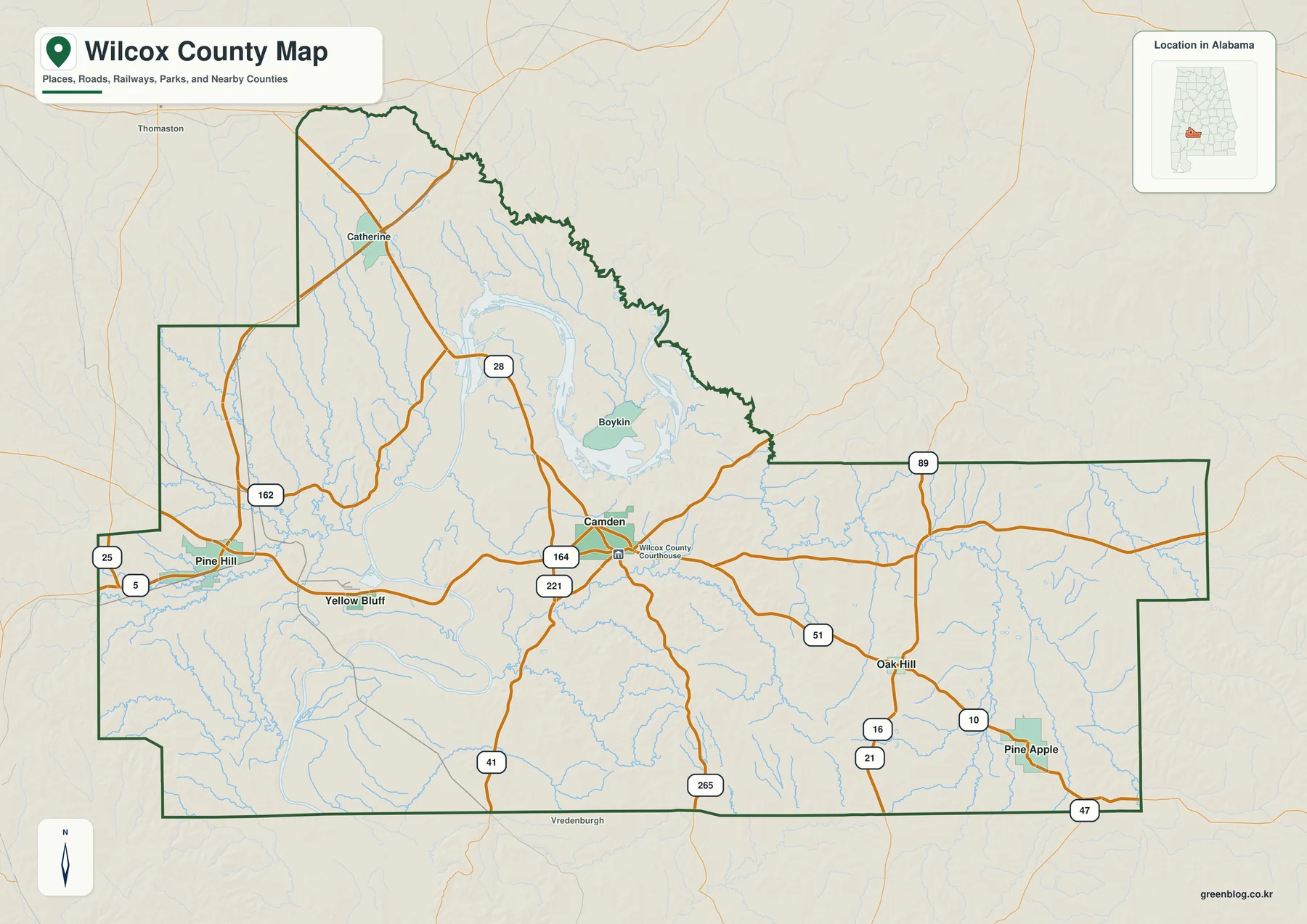
The county outline is irregular rather than rectangular. Its northern side follows a complicated boundary near the river country, while the eastern portion stretches a long distance before stepping inward again near the southeast. Dallas County lies to the northeast, Lowndes and Butler Counties are on the eastern side, Monroe County is to the south, Clarke County is to the southwest, and Marengo County is to the northwest. That shape matters when using the map: Pine Apple is much more naturally related to the Butler County and Greenville direction than to the western edge, while Pine Hill sits closer to the Clarke and Marengo side of the county.
This first map is most useful as an orientation sheet. It is not a turn-by-turn road map, but it lets you place Camden, Pine Hill, Yellow Bluff, Boykin, Catherine, Oak Hill, and Pine Apple against the county boundary and the larger streams. The road shields also show that Wilcox County depends on a network of state and local highways rather than an interstate through the county core. For trip planning, a current navigation service should still be used, but the county map gives a much better sense of which direction each community lies before you zoom into street level.
Why the five-place city map looks so spread out
The city-distribution map focuses on Camden, Pine Hill, Yellow Bluff, Pine Apple, and Oak Hill. Camden sits near the middle, Pine Hill and Yellow Bluff are grouped on the western side, and Pine Apple and Oak Hill occupy the southeast. That simple arrangement communicates something important about Wilcox County: there is no continuous urban strip connecting the named places. Large areas of forest, farmland, creeks, and low-density rural land separate the small municipalities, so the blank space between labels is meaningful rather than missing information.
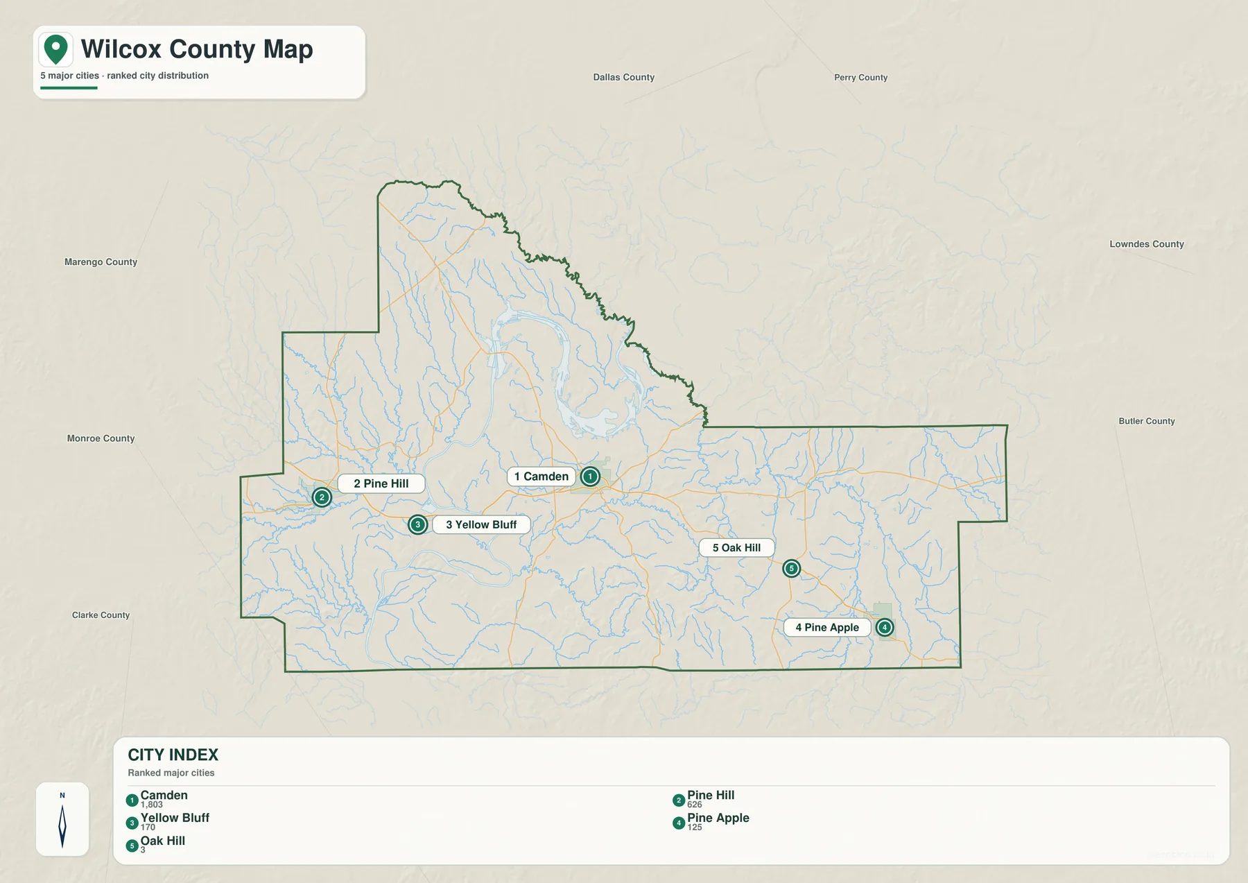
U.S. Census Bureau QuickFacts estimates Wilcox County’s population at 9,666 on July 1, 2025, compared with 10,600 in the 2020 Census. The county had about 887.86 square miles of land and a 2020 population density of 11.9 people per square mile. Those figures fit the visual pattern in the city map. Camden may be the administrative center, but the county’s communities remain physically separated, and a useful countywide reference needs to show the space between them rather than treating the Camden area as if it represented the whole county.
The labels for surrounding counties are also helpful. Marengo and Dallas are shown above the western and central portions of the map, while Lowndes and Butler appear to the east and Monroe and Clarke to the south and southwest. Perry County is labeled farther north beyond the immediate county boundary. These outside names are useful for orientation, but they should not be mistaken for a list of counties that all share a direct boundary with Wilcox. The city map is intended to show where Wilcox sits within the wider region as well as where its major places sit inside the county.
Alabama River bends, Dannelly Reservoir, and downstream waters
The Alabama River dominates the water map. In northern and north-central Wilcox County, the river makes broad bends and widens into the William “Bill” Dannelly Reservoir above Millers Ferry Lock and Dam. The U.S. Army Corps of Engineers describes Dannelly Reservoir as extending about 105 miles along the Alabama River, with an area of roughly 27 square miles and more than 500 miles of shoreline. That helps explain why the water surface on the county map looks more like a network of broad arms and backwaters than a single narrow river channel.
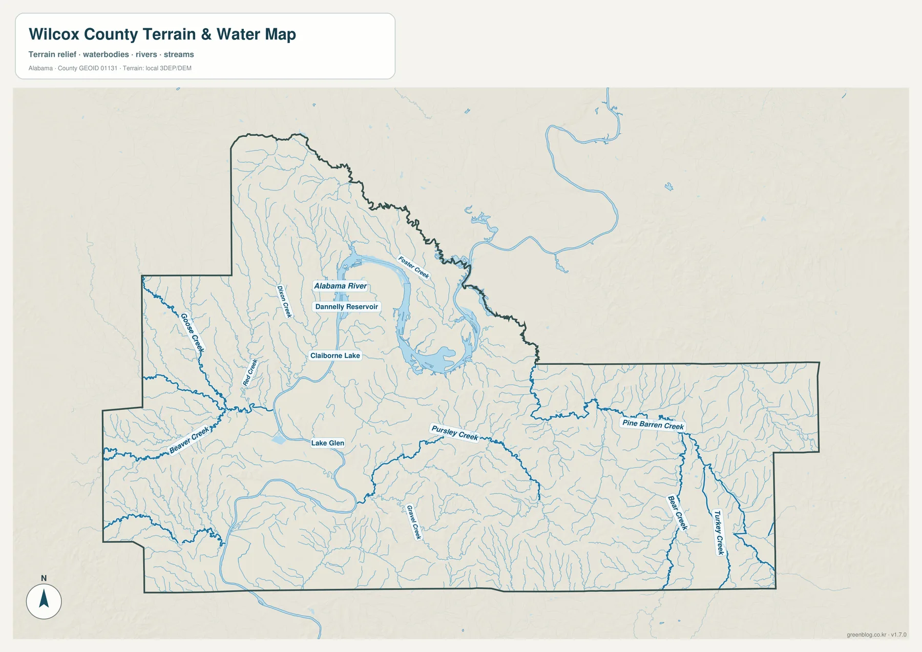
Downstream of Millers Ferry, the map also marks the Claiborne Lake reach, while Lake Glen and numerous smaller creeks fill in the countywide drainage picture. Names visible on the supplied map include Goose Creek and Beaver Creek on the western side and Pine Barren Creek, Bear Creek, Turkey Creek, and other tributaries farther east. These waterways help explain why the outer county boundary alone is not enough for understanding local geography. A road may look direct on a simplified outline, yet a river bend, creek valley, or reservoir arm can change the practical route between two nearby places.
This map should be used as a geographic water reference, not as a flood-risk, boating-depth, parcel, or legal navigation product. It shows where major water features lie relative to the county and terrain, but it does not provide current water levels, hazards, channel depths, or property information. For recreation or navigation on the Alabama River Lakes system, the current guidance from the U.S. Army Corps of Engineers is the appropriate source.
Gee’s Bend shows how a river can change a short trip
Gee’s Bend, closely associated with the official community name Boykin, is one of the clearest examples of physical geography affecting access in Wilcox County. The community sits inside a dramatic loop of the Alabama River northwest of Camden. On a county outline, Boykin can look surprisingly close to the county seat, but the river wraps around the community and makes an overland route much less direct than the straight visual distance suggests. The Gee’s Bend Ferry provides a direct crossing, giving this small part of the county a transportation relationship that cannot be understood from roads alone.
The Wilcox County website lists Boykin among the county’s census-designated places and Gee’s Bend among its communities, while the Encyclopedia of Alabama uses the combined name “Gee’s Bend (Boykin).” For map readers, the practical point is simple: if one source says Boykin and another says Gee’s Bend, look at the large Alabama River meander northwest of Camden. The same location is also culturally significant for the Gee’s Bend quilting tradition, but on these maps the main purpose of the label is to explain the relationship among the community, the river bend, the reservoir reach, and the ferry connection.
Low river bottoms versus the higher southern and eastern ridges
The elevation map makes a contrast that is easy to miss on the road map. Low ground follows the Alabama River and its broad floodplain, appearing mainly in green, while higher rolling terrain becomes more common toward the south and east. The supplied elevation graphic reports an actual county range of about 11 to 163 meters with a mean near 55 meters. Wilcox County is not mountainous, but the relief is strong enough for narrow ridges and branching valleys to stand out clearly, especially in the southern and southeastern part of the county.
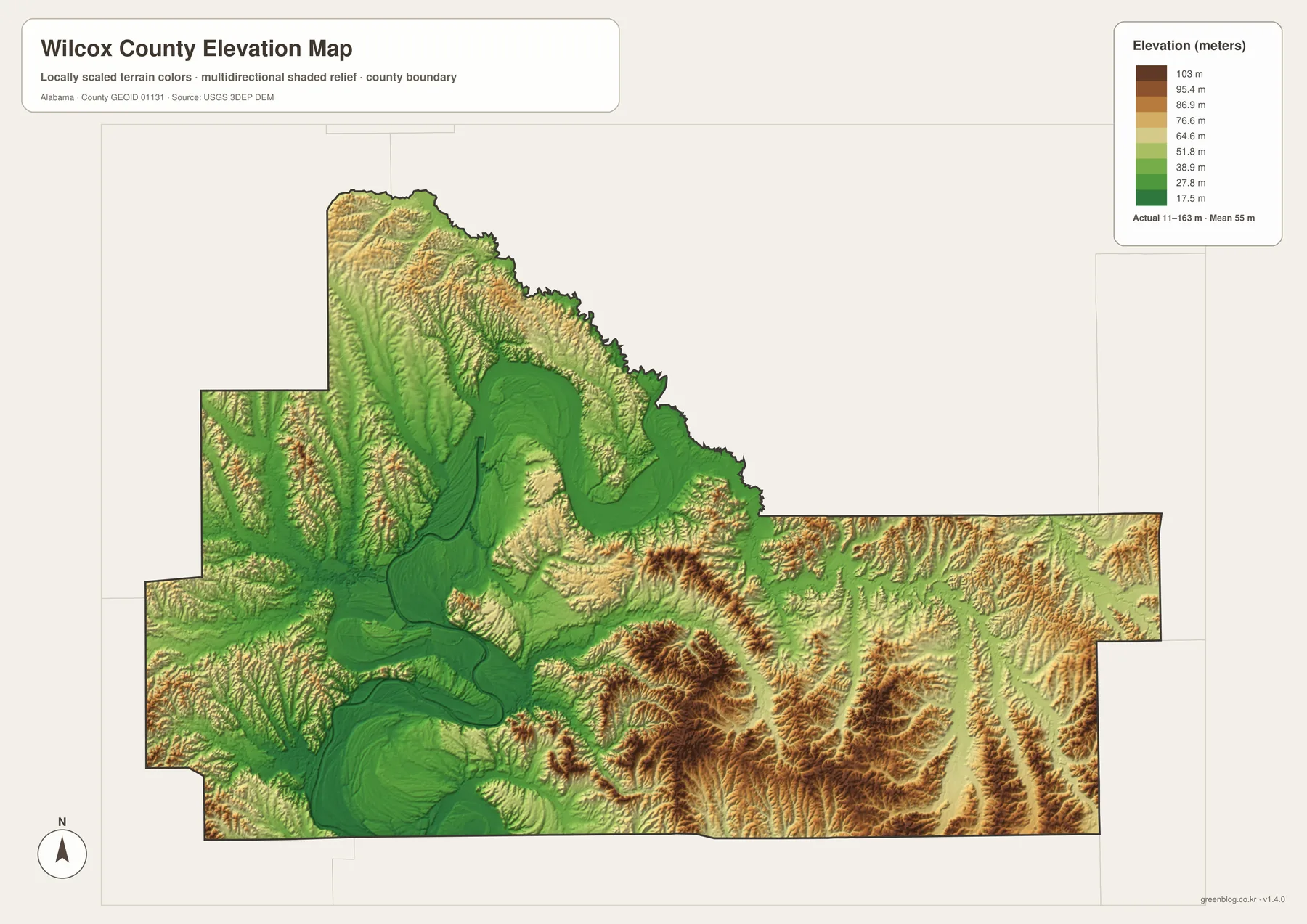
Reading the elevation and water maps together is more useful than treating either one as a standalone graphic. The wide green corridor around the river corresponds to the same winding water system shown in blue on the water map. Farther from that corridor, creeks cut into higher ground and produce a denser pattern of short ridges and valleys. The southeastern area around the Pine Apple and Oak Hill side is especially useful for seeing this difference. The elevation surface is intended for county-scale comparison only; it should not be treated as survey-grade elevation for construction, engineering, drainage design, or a specific parcel.
Black Belt geography behind today’s map
Wilcox County is part of Alabama’s Black Belt and the Coastal Plain. The Encyclopedia of Alabama describes the county as a landscape of rolling prairies and coastal plains crossed by the Alabama River and its tributaries. The region’s dark, productive soils supported a major cotton economy in the nineteenth century, and the river served as a transportation route with many landings for moving agricultural products and passengers. Modern maps obviously show a different transportation system, but the older geography still helps explain why some communities developed near river access while others became more closely tied to inland highways.
Camden itself reflects that history. The county’s official history notes that the first county seat was at Canton Bend on the Alabama River. In 1833 the seat moved to Barboursville, which was later renamed Camden. Today the courthouse and road junctions make Camden the logical administrative reference point on the map, yet the older river-centered settlement pattern remains visible around Millers Ferry and Gee’s Bend. The result is a county where one center does not explain everything: inland roads, the reservoir, river bends, and widely separated small towns all need to be considered together.
Which Wilcox County map works best for your task?
Use the county reference map when you need boundaries, roads, and several communities on one sheet. Choose the city-distribution map when the main question is where Camden, Pine Hill, Yellow Bluff, Pine Apple, and Oak Hill sit relative to one another. The water map is better for the Alabama River, Dannelly Reservoir, Claiborne Lake, and named creeks, while the elevation view is the clearest option for comparing low river bottoms with higher rolling terrain. Using the maps this way avoids overloading one graphic with every possible layer.
- County orientation: compare the boundary, major places, and numbered roads.
- Settlement pattern: focus on the five labeled places and the large rural spaces between them.
- River and reservoir study: follow the Alabama River through the Dannelly and Claiborne reaches and compare named tributaries.
- Terrain comparison: identify the low river corridor and the higher southern and eastern ridges.
For classroom work, regional planning illustrations, travel orientation, or a personal map collection, it can be useful to keep more than one version. The county map answers “where is it?” questions quickly, while the water and elevation maps provide the environmental context behind the road layout. If you need a larger image than the on-page previews, use the ZIP below rather than saving the smaller WebP display image.
Frequently Asked Questions
What is the county seat of Wilcox County, Alabama?
Camden is the current county seat. It appears near the center of the county reference map, where several state routes meet and the Wilcox County Courthouse is labeled. County history records that the first seat was at Canton Bend on the Alabama River and moved in 1833 to Barboursville, the town later renamed Camden.
Are Boykin and Gee’s Bend the same place?
The names are closely connected. The Encyclopedia of Alabama identifies the community as “Gee’s Bend (Boykin),” while local county listings may show Boykin and Gee’s Bend in different community categories. For map orientation, both names point to the distinctive Alabama River bend northwest of Camden, so the large meander is the most reliable landmark for finding the area.
What files are included in the map download?
The download archive contains four high-resolution A3 JPG files: county, city, water, and elevation maps. The images embedded in the article are WebP previews optimized for the web, so they are not the same file size or format as the downloadable originals. Use the ZIP when you want the larger versions for printing or offline use.
Map File Information
Wilcox County A3 map files
- Included Versions: county, city, water, and elevation
- Included Files: four high-resolution A3 JPG maps
Related Maps
- Abbeville, Headland, and Lake Eufaula on the Henry County Alabama Map
- Athens to Wheeler Reservoir on the Limestone County Alabama Map
- Autauga County Alabama Land Cover Map
Sources and references
- U.S. Census Bureau QuickFacts — Wilcox County, Alabama — population, land area, and density
- Wilcox County, Alabama official website — county seat, communities, and local history
- Alabama Department of Transportation — Wilcox County Highway Functional Classification — roads and transportation reference
- U.S. Army Corps of Engineers — Alabama River Lakes — Dannelly Reservoir and Claiborne Lake
- Encyclopedia of Alabama — Wilcox County — Black Belt geography, history, and communities
- USGS 3D Elevation Program — elevation-data reference
Green Map creates custom-edited map images using open geographic data sources such as geoBoundaries, Natural Earth, OpenStreetMap, and government open data. These maps are edited visual materials, not raw data files, and are provided for education, documents, presentations, and graphic reference.