A Hualien County map needs a tall frame because the county runs for a long distance along eastern Taiwan. The supplied 1200 × 1697 images use that portrait shape to keep all 13 first-level local divisions visible, from the immense Xiulin area in the north to Fuli at the southern tip. A horizontal layout would either waste space or force the narrow north–south structure into a much smaller scale.
The collection contains three administrative views: a labeled color map, a labeled black-and-white map, and an unlabeled version that retains every internal boundary. This is not a road, terrain, or tourist-attraction set. The files do not plot highways, rail lines, rivers, mountain relief, elevation, settlement points, a north arrow, coordinates, or a distance scale. Their purpose is to make the county’s administrative pattern readable for lessons, reference sheets, presentations, and custom annotation.
Hualien’s geography explains why the shapes are so uneven. The county faces the Pacific Ocean and extends between major mountain systems, while inhabited valley areas form a long corridor through the interior. On the Hualien County map, three large western mountain townships—Xiulin, Wanrong, and Zhuoxi—occupy much more page area than the compact northern divisions around Hualien City. Color helps separate those contrasts, but the colors themselves do not represent geographic data.
Table of Contents
Printable Hualien County Map Overview
Hualien County has 13 local administrative divisions: one city, two urban townships, and 10 rural townships. Hualien is the city and county seat. Fenglin and Yuli are the two urban townships. The other divisions are Xincheng, Xiulin, Ji’an, Shoufeng, Guangfu, Fengbin, Ruisui, Wanrong, Zhuoxi, and Fuli.
The portrait layout gives each name enough room without rotating the complete county. Xiulin dominates the north and extends far inland, while Xincheng forms a narrow coastal area beside it. Hualien City is so compact that its label sits outside the boundary with a leader line; Xincheng uses a similar treatment. Ji’an appears directly inland from Hualien City, and Shoufeng begins the longer sequence toward the center and south.
All three files share the same 1200 × 1697 proportions, so they can be exchanged in an A3-oriented document without rebuilding the surrounding page. The color and monochrome versions are labeled references. The outline file is a blank-label administrative base: it removes the names and fills but preserves the 13 internal areas. That makes it more informative than a single county silhouette.
Regional Layout of Hualien County
The county’s official geographic description places the Pacific Ocean to the east and the Central Mountain Range to the west. It also identifies the Coastal Range on the eastern side of the interior and the valley plains between the mountain systems. Those physical features are not drawn on these administrative images, but they help explain why many populated places and smaller divisions follow a narrow north–south band.
Reading a Hualien County map from north to south begins with Xiulin, Xincheng, Hualien City, and Ji’an. Shoufeng bridges the compact northern group and the central part of the county. Fenglin, Guangfu, and Ruisui continue along the interior corridor, while Fengbin follows a long section of the eastern coast. Farther south, Yuli and Fuli occupy the valley side as Zhuoxi spreads across a much broader mountain area to the west.
Wanrong creates another important contrast in the middle of the image. It is broad from east to west and lies beside several much narrower divisions, including Fenglin and Guangfu. The map therefore communicates administrative size and adjacency, but not landform height or travel time. A large polygon does not necessarily contain a large urban population, and adjacent shapes on the page may still be separated by difficult terrain.
The county extends roughly 137.5 kilometers north to south, according to the Hualien County Government’s geographic overview. This length is one reason the supplied portrait composition is appropriate. The official page also describes an area of about 4,628.6 square kilometers, but readers should use an authoritative geographic or transport map—not these images—when they need precise distance, route, or elevation information.
Color Administrative Map
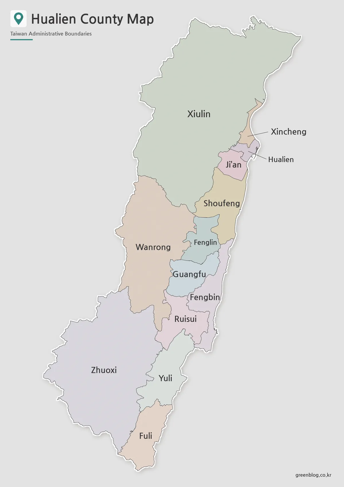
The color image assigns a separate pastel fill to each division. That treatment is especially effective where small northern areas meet the much larger Xiulin and Shoufeng shapes, and where narrow central divisions sit between Wanrong and Fengbin. The palette is categorical only. It does not indicate population, altitude, township status, land use, indigenous population, or any other measured variable.
Labels are placed directly inside most areas, but the smallest coastal shapes require a different solution. Leader lines connect the external Xincheng and Hualien labels to their boundaries, preventing the text from covering the narrow polygons. This design choice keeps the northern cluster legible while allowing Xiulin, Ji’an, and Shoufeng to retain centered labels.
Use the color Hualien County map when an audience needs to recognize divisions quickly. A teacher can compare the mountain townships with the valley and coastal sequence, while a presentation can trace the county from Xiulin through Ruisui and Yuli to Fuli. If the image is edited to carry statistics, replace the decorative fills with a documented color scale and add a legend, source, and reference year.
Black and White Printable Map
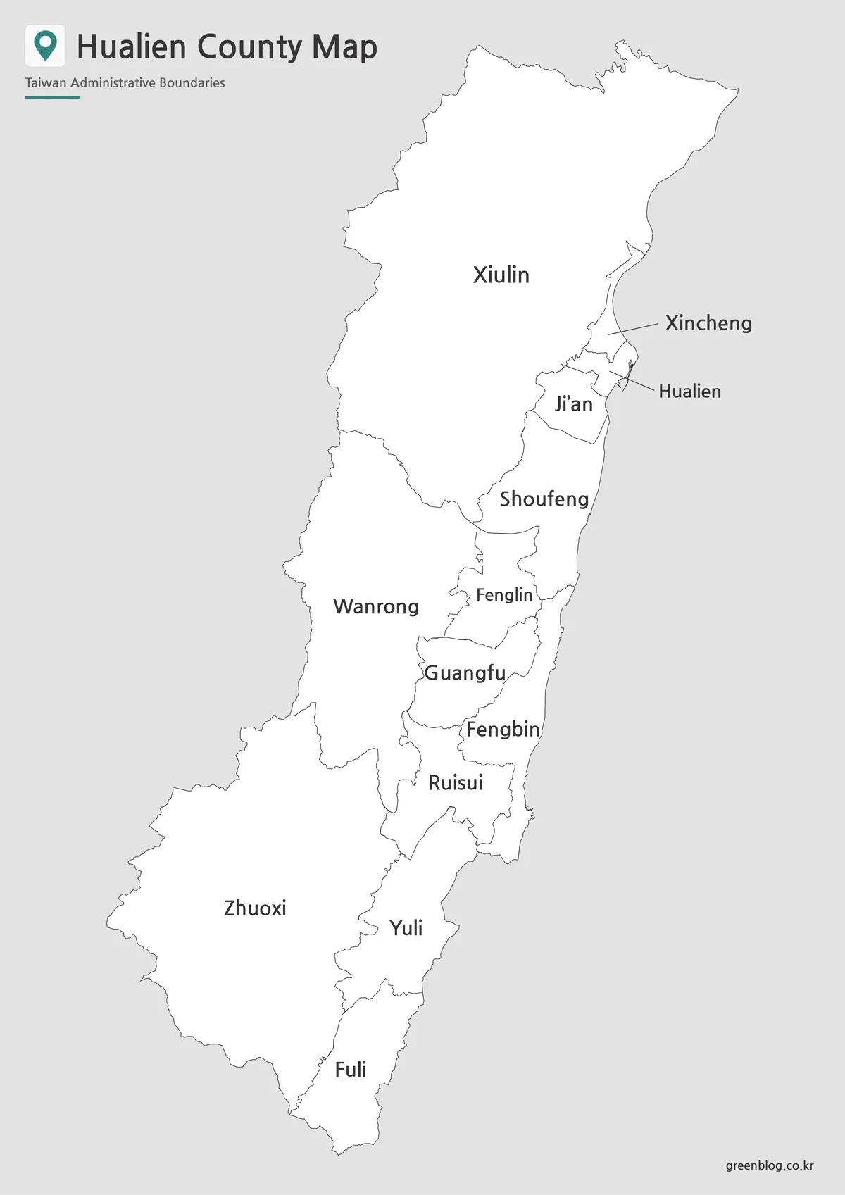
The black-and-white Hualien County map keeps the full boundary network and all 13 names while removing the colored fills. It is the clearest choice for a grayscale report, photocopied handout, or reference page that must sit beside substantial text. Because the information is carried by lines and labels, readers do not need a color printer to identify the administrative pattern.
The elongated canvas preserves generous vertical spacing for Xiulin, Wanrong, Zhuoxi, and the southern Yuli–Fuli pair. Even so, the Hualien City and Xincheng callouts remain the most delicate elements when the image is reduced. Preserve the aspect ratio, avoid squeezing the map into a wide box, and check those leader lines in a trial print before producing multiple copies.
This labeled version can also serve as an answer key for a blank-map exercise. Students can compare their placement of Fenglin, Guangfu, Fengbin, and Ruisui with the reference, then verify how the compact central divisions align with the larger townships on either side. The map still does not distinguish the city and two urban townships by symbol, so a separate classification key may be helpful.
Blank Outline Map for Editing
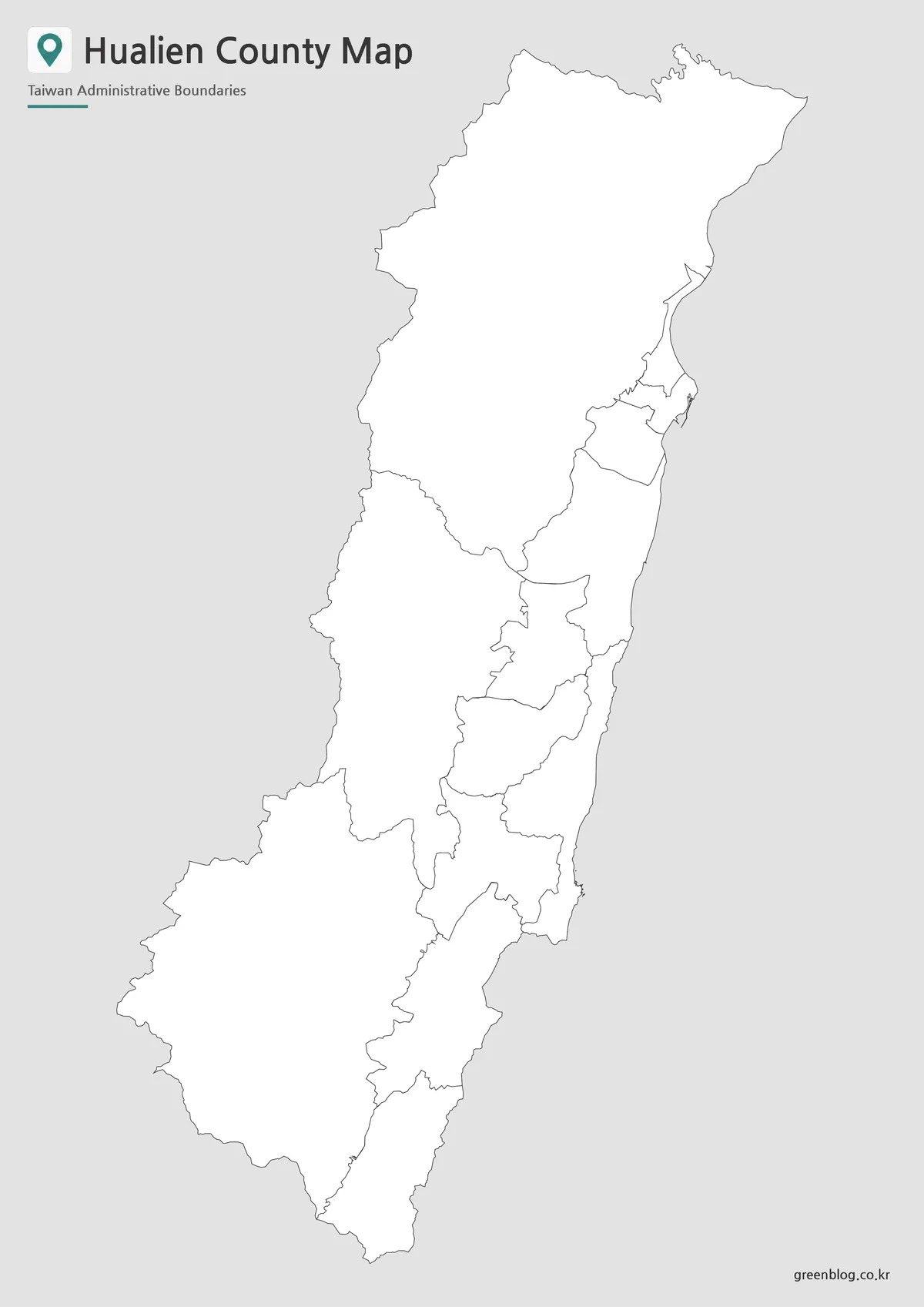
The third file removes every geographic label and all colored fills but retains the title, subtitle, county edge, and internal divisions. It is therefore an unlabeled administrative map rather than a pure outline. The small boundaries around Hualien City and Xincheng remain visible even though the leader lines and names are gone.
A blank Hualien County map supports several concrete exercises. Learners can label the 13 divisions, group Hualien City with Fenglin and Yuli as the city-and-town set, identify the three broad mountain townships, or shade Fengbin as the long central coastal division. Editors can add verified river, railway, route, or attraction information on separate layers, but those features are not supplied in the base artwork.
The image is a raster file, not a confirmed vector source, so it should not be described as SVG or fully editable boundary data. Keep an untouched copy before annotation, define any symbols in a legend, and provide descriptive alternative text for the completed graphic. If a project requires legally authoritative boundaries or coordinate-based analysis, use a current official geographic dataset instead.
Practical Uses for the Map Collection
For classroom use, the three Hualien County map files can create a simple sequence. Begin with the color version to establish the north–south structure, use the monochrome version during reading or discussion, and finish with the blank-label image for recall. A focused activity can ask why Xiulin, Wanrong, and Zhuoxi appear so large while Hualien City needs an external callout, then distinguish administrative area from population or urban importance.
Presentation designers can divide the county into northern, central, and southern reading bands without changing the boundaries. The north can emphasize Hualien City, Xincheng, Ji’an, and Xiulin; the center can compare Shoufeng, Fenglin, Guangfu, Fengbin, Wanrong, and Ruisui; and the south can focus on Yuli, Zhuoxi, and Fuli. Keep the complete county visible on at least one slide so cropped details retain geographic context.
When adapting the Hualien County map for data, verify that the dataset uses the same 13 administrative units and the same reference date. Do not attach a city-level value to the county as a whole or confuse a township label with a settlement point. Cite the data source, explain missing values, and use a legend whose classes remain distinguishable in both color and grayscale.
Document editors should retain the 1200 × 1697 ratio and allow the map enough height. A portrait page suits the artwork naturally; a landscape slide may need the image centered with explanatory text beside it. Cropping the outer gray margin is possible, but protect the northern tip, the Fuli boundary, and the small Hualien–Xincheng callout area from accidental clipping.
Frequently Asked Questions
Where is Hualien County located?
Hualien County is located in eastern Taiwan. It faces the Pacific Ocean to the east and the Central Mountain Range to the west.
What versions are included in the Hualien County map collection?
The collection includes a color map, a black and white map, and an outline map.
Can I print the Hualien County map in A3 size?
Yes. The map is prepared for an A3 layout, making it suitable for classroom materials, posters, handouts, and presentation use.
Is the outline map blank?
Yes. The outline version removes color while keeping the county outline and internal administrative boundary lines. It is useful for editing, coloring, and adding custom labels.
Map File Information
This download contains three portrait administrative images of Hualien County for labeled reference, monochrome printing, and blank-map annotation.
- Included Versions: Color labeled map, black-and-white labeled map, blank-label boundary map
- Printable Size: A3 portrait layout
- File Type: Image files
- Intended Use: Classroom exercises, reference sheets, presentations, and custom data graphics
Related Maps
Additional Resources
- Hualien County Government: Location and Landscape — learn how the county’s coastline, mountain ranges, valleys, rivers, area, and long north–south extent shape its geography.
Green Map creates custom-edited map images using open geographic data sources such as geoBoundaries, Natural Earth, OpenStreetMap, and government open data.
These maps are edited visual materials, not raw data files, and are provided for education, documents, presentations, and graphic reference.