The Okinawa Prefecture Map is useful when you need more than a simple location image of Japan’s southern island region. Okinawa is made up of the main island and many surrounding island groups, including the Miyako Islands and the Yaeyama Islands. Because these areas are spread across a wide ocean area, a clear printable map helps explain regional layout, municipal boundaries, travel routes, and island relationships much better than a small reference image.
Okinawa Prefecture is located in the Ryukyu Islands, between the East China Sea and the Pacific Ocean. Naha is the prefectural capital, and other important areas include Okinawa City, Uruma, Nago, Miyakojima, and Ishigaki. The prefecture has a population of about 1.46 million people and is one of Japan’s most recognizable island regions. For map users, the most important point is not only where Okinawa is located, but how its islands and municipalities are arranged.
This printable Okinawa Prefecture Map collection includes three versions: a color map, a black and white labeled map, and a blank outline map. The files are prepared in JPG format and designed for A3 high-resolution printing. They are suitable for classroom handouts, travel planning, presentation slides, blog graphics, regional comparison materials, and editable infographic projects.
Table of Contents
Okinawa Prefecture Map Overview
Okinawa is different from many other Japanese prefectures because its administrative areas are spread across multiple islands. The main island includes Naha, Okinawa City, Uruma, and Nago, while Miyakojima and Ishigaki are located farther southwest.
For this reason, the map layout was adjusted so that both the main island and the outer island groups remain easy to recognize. During preparation, extra attention was given to label placement and boundary visibility, especially around smaller islands where names and lines can quickly become crowded.
Included Map Versions
This Okinawa map collection includes:
- Color municipal boundary map
- Black and white labeled map
- Blank outline map
- JPG file format
- A3 high-resolution print support
- Versions for printing, presentation, education, and editing
Each version has a different purpose, so users can choose the map that fits their project instead of using one general image for every situation.
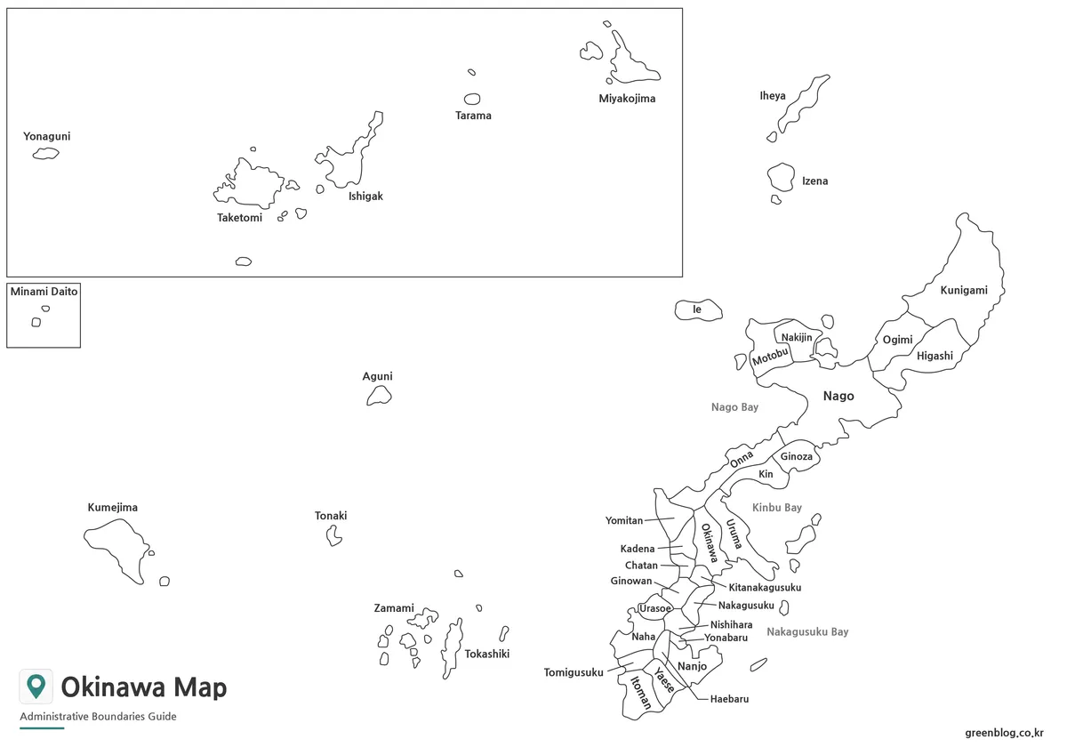
Color Okinawa Map with Municipal Boundaries

The color version separates Okinawa’s municipalities with different colors. This makes it easier to compare areas on the main island and identify smaller island regions.
It works well for regional explanation slides, classroom materials, travel content, and visual study resources. Color contrast was adjusted so neighboring areas do not blend together too easily when printed or inserted into a presentation.
Black and White Printable Version
The black and white version focuses on labels and boundary lines. It is useful when color is not needed or when the map will be printed in grayscale.
This version is especially helpful for reports, handouts, and simple reference materials. The layout keeps major places such as Naha, Okinawa City, Uruma, Nago, Miyakojima, and Ishigaki readable without making the page feel crowded.
Blank Outline Map for Editing
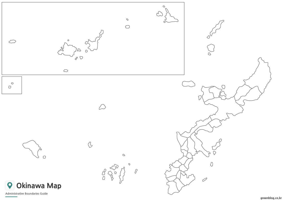
The outline version removes colors and labels, leaving only the boundary structure. This makes it useful for editing work, educational worksheets, infographic layouts, and custom annotation projects.
Users can add travel routes, tourism spots, statistical data, highlighted regions, or presentation notes directly on top of the map. The simplified line structure also makes it easier to use as a background image in graphic design software.
Practical Uses for the Map
The Okinawa Prefecture Map can be used for many visual projects, including:
- Classroom geography handouts
- Japan prefecture study materials
- Travel route planning
- Blog and website graphics
- Presentation slides
- Printable worksheets
- Infographic design
- Regional comparison projects
Because Okinawa includes many island areas, the map is especially useful when explaining distance, regional grouping, or island-based administrative divisions.
Frequently Asked Questions
Does this Okinawa Prefecture Map include municipal boundaries?
Yes. The map versions are designed around Okinawa’s municipal and administrative boundary structure.
Can I print the map in A3 size?
Yes. The map was prepared for high-resolution A3 printing.
Is there a blank version for editing?
Yes. The outline map is suitable for editing, coloring, labeling, and infographic work.
Which version is best for classroom use?
The black and white map works well for printing, while the outline map is useful for worksheets and student activities.
Okinawa Prefecture Map Download
Download the Okinawa Prefecture Map collection and choose the version that fits your project. Color, black and white, and outline maps are included for printing, classroom use, presentation work, and graphic editing.
- File Format: JPG
- Print Size: A3 high resolution
- Included Versions: Color map / Black and white map / Outline map
- Intended Use: Printing · Education · Presentation · Editing
Additional Resources
- Geospatial Information Authority of Japan (GSI) — Official Japanese map and geospatial information source.
Related Maps
- 4 Japan Maps Download Collection for Print and Design
- South Korea Maps Download: 6-Map Collection
- China Maps Download Collection – 4 Regional Map Types