Webster County lies in south-central Nebraska, where Red Cloud anchors a group of small communities above the Republican River valley. This Webster County Nebraska Map page combines the U.S. 281 and Nebraska 136 road network with straight-line city connections to Cowles, Guide Rock, Blue Hill, and Bladen, plus a water map and elevation view showing the county’s descent from higher northwestern uplands to the broad southern river bottom. The WebP previews are designed for quick viewing, and the same four maps can be downloaded below as high-resolution JPG files in one ZIP archive. High-resolution map files are available for download in the section below.
Red Cloud and the Republican River are the easiest anchors for understanding the county. Red Cloud is the county seat and sits near the junction of U.S. 281 and Nebraska 136. Guide Rock lies east along the same southern corridor, Cowles is north of Red Cloud, and Blue Hill and Bladen occupy the northern part of the county. That arrangement makes the contrast between the southern river valley and the higher northern agricultural country especially clear.
Table of Contents
Red Cloud where U.S. 281 meets Nebraska 136 above the Republican River
The general county map makes Red Cloud the strongest reference point. U.S. 281 runs north-south through the community and continues toward Kansas, while Nebraska 136 crosses the southern part of the county from west to east and links Red Cloud with Guide Rock. Because the two routes meet close to the Republican River valley, the county seat is easy to locate even before the smaller roads and towns are considered.
Guide Rock sits east of Red Cloud along Nebraska 136. Cowles is farther north in the central interior, while Blue Hill and Bladen occupy the northern tier. Inavale appears west of Red Cloud near the Republican River. Campbell and Lawrence are useful labels outside the county boundary, but the dark outline should be used to distinguish nearby reference towns from communities actually inside Webster County.
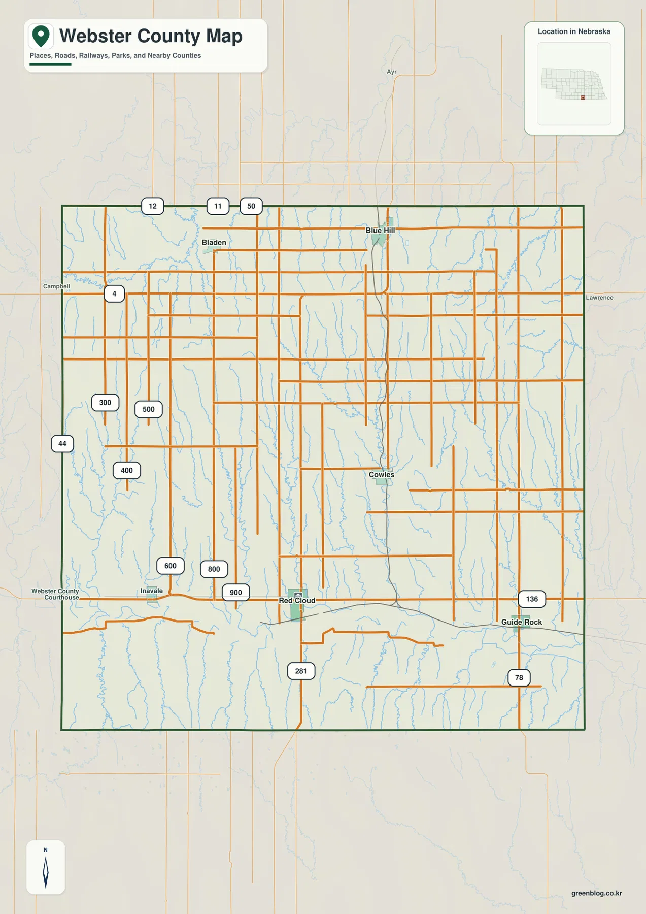
The northern road pattern contains several long east-west rural routes, with Nebraska 4 near the western side and additional state routes continuing beyond the county. South of the main settlement belt, U.S. 281 provides the clearest north-south reference from Red Cloud. Nebraska 78 appears near the southeastern side. Together, these roads show a county whose northern farm network and southern river corridor have noticeably different layouts.
This map is a regional reference rather than a live navigation product. Construction, detours, and seasonal road conditions can change after a static map is made. Its value is orientation: it quickly shows how Red Cloud relates to Guide Rock, Blue Hill, and Bladen, where U.S. 281 crosses Nebraska 136, and how the county boundary separates local communities from nearby towns.
Straight-line connections from Red Cloud to four smaller communities
The city-connections graphic uses Red Cloud as its hub and links it with Cowles, Guide Rock, Blue Hill, and Bladen. The CITY CONNECTIONS index places Red Cloud first, Blue Hill second, Guide Rock third, Bladen fourth, and Cowles fifth. With most road detail removed, the panel makes direction and spacing easier to compare than the general map does.
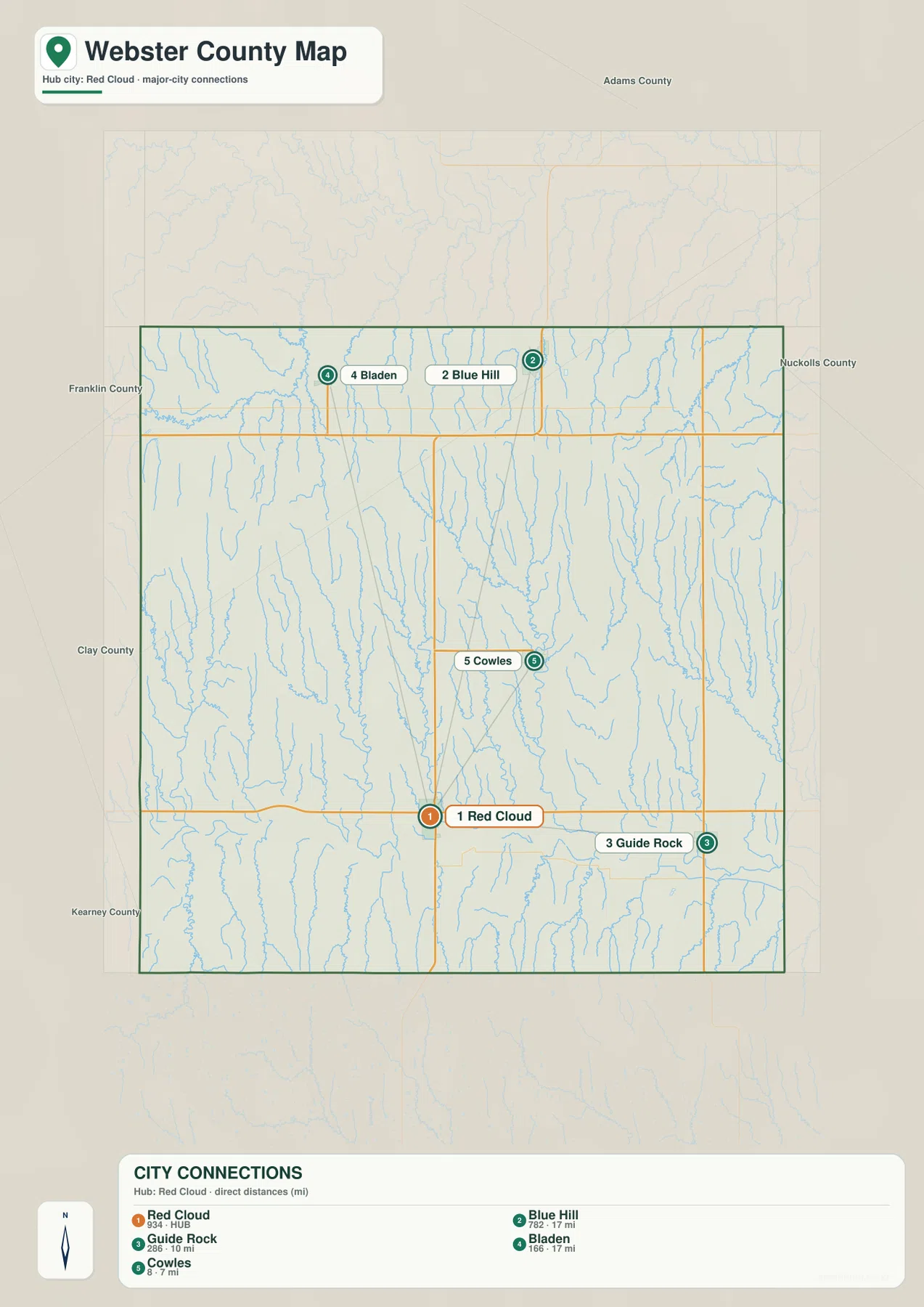
The graphic shows about 7 miles from Red Cloud to Cowles, 10 miles to Guide Rock, and roughly 17 miles to both Blue Hill and Bladen. These are straight-line distances, not road mileage. Actual driving distances can be longer because roads follow section lines, creek valleys, and available Republican River crossings instead of a direct line.
Cowles is the closest ranked community, while Guide Rock provides the main eastern reference along the river corridor. Blue Hill and Bladen are similar distances from Red Cloud but lie in different parts of the northern county. That combination makes the city panel useful for visualizing the county’s north-south scale without confusing direct distance with a recommended travel route.
Republican River lowlands beneath Elm, Beaver, and Farmers creek valleys
The Republican River is the defining water feature in southern Webster County. It runs from west to east through a broad low corridor near Red Cloud and Guide Rock. Walnut Creek and Hicks Creek join the southern system, and Pawnee Lake is labeled near the Republican River in the eastern half. The river valley is also the clearest lowland on the elevation map.
Farther north, East Fork Farmers Creek and Moon Creek drain the western interior. Cowles Creek and Dry Creek cut through the central uplands, while West Fork Elm Creek joins Elm Creek farther east. Beaver Creek forms a prominent winding valley in the eastern half, and Oak Creek appears in the northeast. Together these streams create a strong north-to-south drainage pattern toward the Republican River.
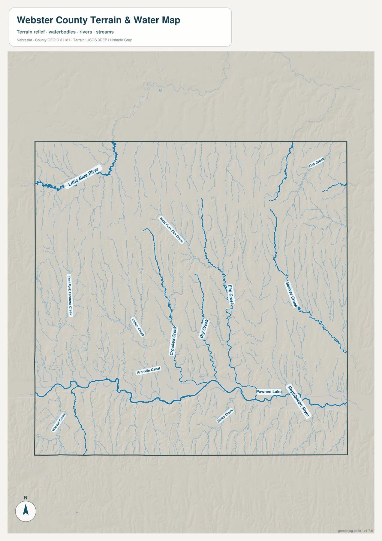
The Little Blue River appears near the northwestern side and belongs to a different major drainage system from the Republican River. That detail matters because Webster County is not simply one south-draining basin. The Franklin Canal is also labeled in the southwest; unlike the natural creeks, it is an artificial waterway and should not be interpreted as the same type of feature.
Blue line thickness and color do not represent discharge, depth, or flood risk. The map is designed to show the location of rivers, creeks, and canals at county scale. Floodplain determinations, irrigation questions, stream access, and safety decisions require current information from USGS, FEMA, and the relevant local water agencies.
A 491-to-642-meter descent from the northwest to the Republican River valley
The elevation map shows one of the county’s clearest geographic patterns. The displayed surface ranges from about 491 to 642 meters, with a mean near 572 meters. Dark brown and orange dominate the northwest, while colors become progressively lighter toward the east and south. The Republican River forms a long green lowland across the southern part of the county.
Numerous tributaries carve narrow valleys through the northern and central uplands. West Fork Elm Creek, Elm Creek, Beaver Creek, and the smaller central channels all descend from higher ground toward the Republican River. The resulting shaded relief is much more dissected than the regular rural road grid suggests, with narrow ridges separating many parallel creek valleys.
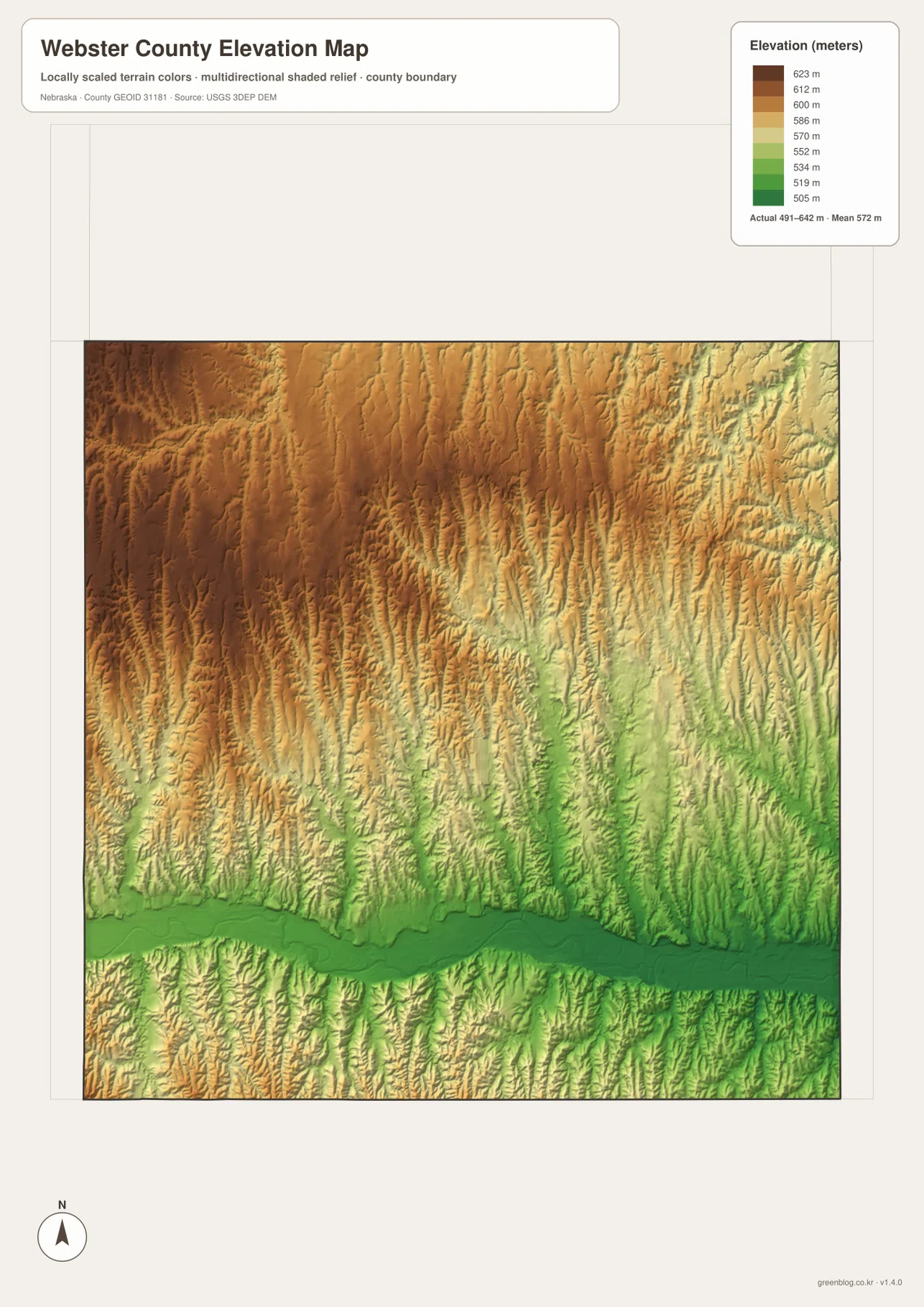
Red Cloud and Guide Rock sit close to the lower river corridor, while Blue Hill and Bladen occupy higher northern terrain. Moving only a short distance north from the Republican River brings the map back into a repeated pattern of ridges and tributary valleys. That contrast explains why the county can appear broadly agricultural while still containing substantial local relief.
This elevation surface is intended for county-scale comparison, not parcel surveying or engineering. Exact site elevations, road grades, construction benchmarks, and design values require USGS source data, professional surveying, or another appropriate technical source. Here the image is most useful for comparing the northwestern uplands, central creek valleys, and the Republican River bottom.
Red Cloud county-seat history and Willa Cather’s Webster County landscape
The Webster County comprehensive plan states that county boundaries were established by the Territorial Legislature in 1867 and that Webster County became a separate county about four years later. It was named for American statesman Daniel Webster. The county seat was placed on the claim of Silas Garber, a location that developed into Red Cloud, and early settlement grew strongly along the fertile Republican River Valley.
Red Cloud is also nationally known through author Willa Cather. The National Willa Cather Center identifies Red Cloud as Cather’s hometown and preserves a remarkable group of historic places connected to her life and writing. They include the Willa Cather Childhood Home, the Red Cloud Opera House, and other buildings and landscapes that appear directly or indirectly in her fiction.
The literary landscape extends beyond the town itself. The National Willa Cather Center preserves rural sites elsewhere in Webster County, including the Pavelka Farmstead near Bladen, as well as prairie landscapes associated with Cather’s work. The county map provides useful regional context for these places because it shows the distance between Red Cloud and the northern farming communities without pretending to be a detailed heritage-tour map.
That combination of literary history and physical geography makes Webster County unusual. Red Cloud sits near the broad Republican River valley, while the country to the north rises into creek-cut agricultural uplands. Seeing both on the same page helps explain the real landscape behind a town that became one of the best-known settings associated with an American author.
A practical order for comparing towns, water, and relief
Begin with the general county map by locating Red Cloud and then Guide Rock, Cowles, Blue Hill, and Bladen. The city-connections panel provides a second view by showing straight-line spacing from Red Cloud. Because the mileage labels are not driving distances, they work best as a county-scale reference rather than a route-planning tool.
Next, use the water map to trace the Republican River and locate Elm Creek, Beaver Creek, and Dry Creek. The elevation image then shows how those streams occupy lower corridors between higher ridges. The contrast is especially strong between the northwestern high ground and the long green Republican River valley in the south.
High-resolution JPG files are better suited to printing and close inspection when smaller creek names and route numbers matter. These maps remain regional references rather than legal or safety documents. County boundaries can be checked against Census TIGER/Line data, waterways against USGS National Hydrography, and elevation against the USGS 3D Elevation Program.
Frequently Asked Questions
Are the Red Cloud-to-Blue Hill, Guide Rock, Cowles, and Bladen mileages driving distances?
No. The city-connections map shows straight-line distances of about 7 miles from Red Cloud to Cowles, 10 miles to Guide Rock, and roughly 17 miles to both Blue Hill and Bladen. Actual road mileage can be longer because highways and local roads do not follow a direct line.
Where does the Republican River cross Webster County?
The Republican River crosses the southern part of the county from west to east, close to Red Cloud and Guide Rock. Elm Creek, Beaver Creek, Dry Creek, and several other tributaries descend from higher northern terrain toward the river system.
Can this county map replace a Willa Cather historic-site visitor map?
No. It provides regional context for Red Cloud and nearby Webster County communities, but it does not show individual historic buildings, tour routes, or current visitor services. Use the National Willa Cather Center’s current visitor information for those details.
Map File Information
Download the four high-resolution JPG maps shown on this page for Webster County in one ZIP archive.
- Included Files: Use only the versions confirmed in the article and supplied images
- File Type: Use the confirmed download contents
- Intended Use: Printing, education, presentations, and map-based projects
Related Maps
Sources and references
County organization, Red Cloud county-seat history, and early Republican River Valley settlement come from the Webster County comprehensive plan. Red Cloud and Willa Cather historic-site background comes from the National Willa Cather Center, while the federal sources below provide authoritative references for boundaries, hydrography, and elevation.
- Webster County – Comprehensive Plan
- National Willa Cather Center – Visit Red Cloud
- National Willa Cather Center – Historic Sites
- U.S. Census Bureau – TIGER/Line Shapefiles
- USGS – National Hydrography
- USGS – 3D Elevation Program
Green Map creates custom-edited map images using open geographic data sources such as geoBoundaries, Natural Earth, OpenStreetMap, and government open data. These maps are edited visual materials, not raw data files, and are provided for education, documents, presentations, and graphic reference.