Knox County lies in northeastern Missouri, where Edina serves as the central town and smaller communities such as Hurdland, Baring, Knox City, Newark, and Novelty are spread across a largely rural landscape. Routes 6, 15, 156, 151, 137, 183, and 217 provide the main road references. Several branches of the Fabius River cut long valleys through the county, and the elevation layer ranges from about 158 to 278 meters. The western side is generally higher, while the central and eastern river corridors are lower. High-resolution JPG versions of the map themes are available together in the ZIP for printing or offline use. High-resolution map files are available for download in the section below.
The easiest way to understand Knox County is to begin with Edina and then compare the towns in different directions. Hurdland lies west, Baring north, Knox City east, and Newark southeast. The road network looks simple at first, but the terrain-and-water map reveals a dense pattern of forks, creeks, and valleys. Matching those waterways with the elevation layer explains why broad farm country is broken into long ridges and lower stream corridors.
Table of Contents
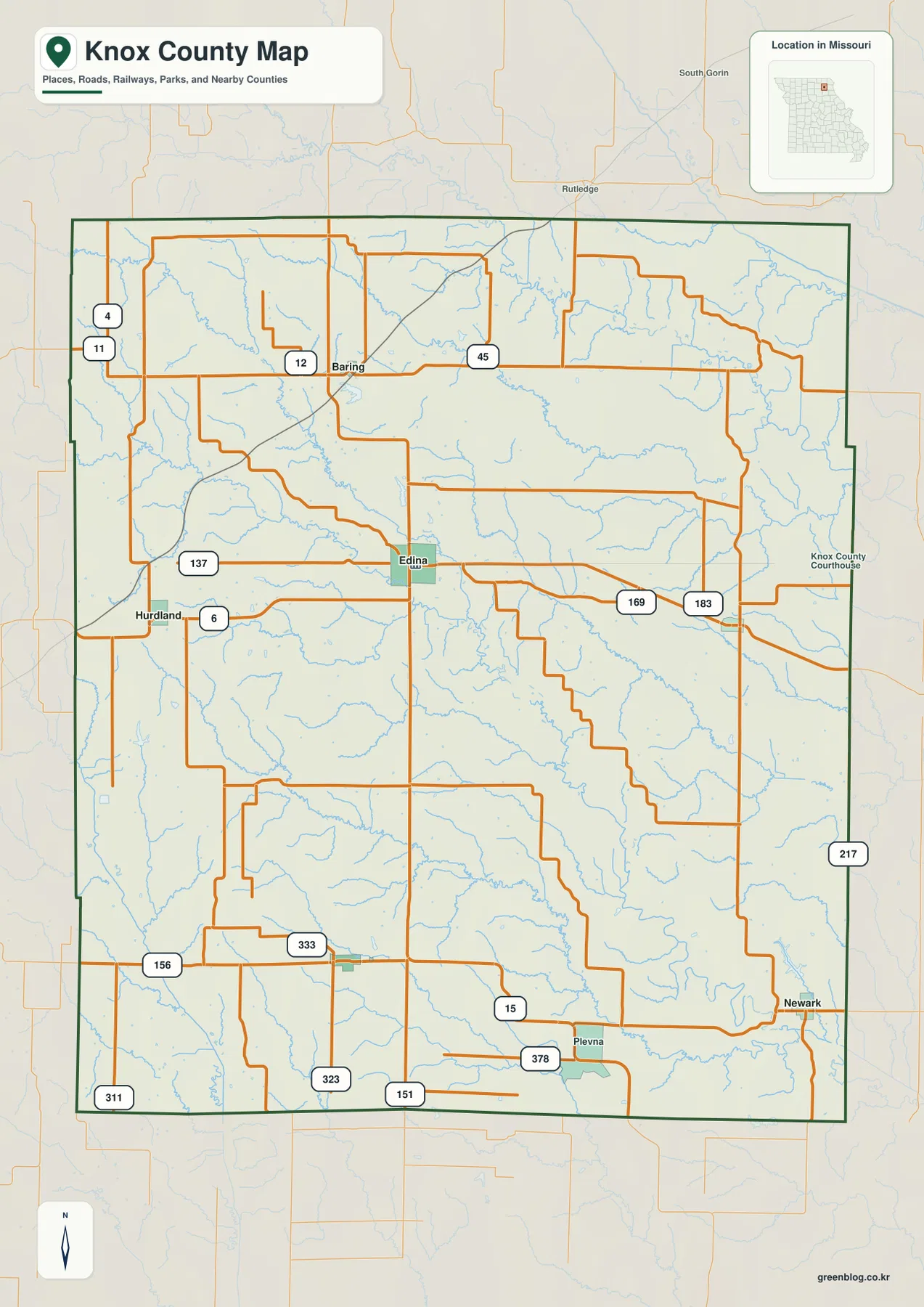
Edina and Route 6 provide the clearest county orientation
Edina is the most prominent town near the center of the general map. Route 6 crosses the county through Edina and connects west toward Hurdland and east toward Knox City, while Route 15 provides a north-south reference. Routes 12 and 45 appear near Baring in the north, and Routes 151, 156, 323, 333, and 378 help organize the southern half.
The Knox County Courthouse is labeled in Edina. The county’s official website also identifies Edina as the county seat and lists the courthouse at 107 N 4th Street. Once Edina is located, the other major communities are easy to place around it, making the town the best starting point for the road map.
Hurdland, Baring, and Newark anchor different parts of the county
Hurdland lies west of Edina along the Route 6 corridor and is a useful reference for the higher western side of the county. Baring sits in the north near Route 12, between rural uplands and the Fabius drainage. Newark lies near the southeastern edge and helps orient the lower South Fabius country.
Plevna appears west of Newark in the southern rural area, while Novelty is shown separately on the ranked city layer in the south-central part of the county. Knox City lies east of Edina. These settlements do not form one continuous urban corridor; each functions as a local reference within a landscape of farms, ridges, and stream valleys.
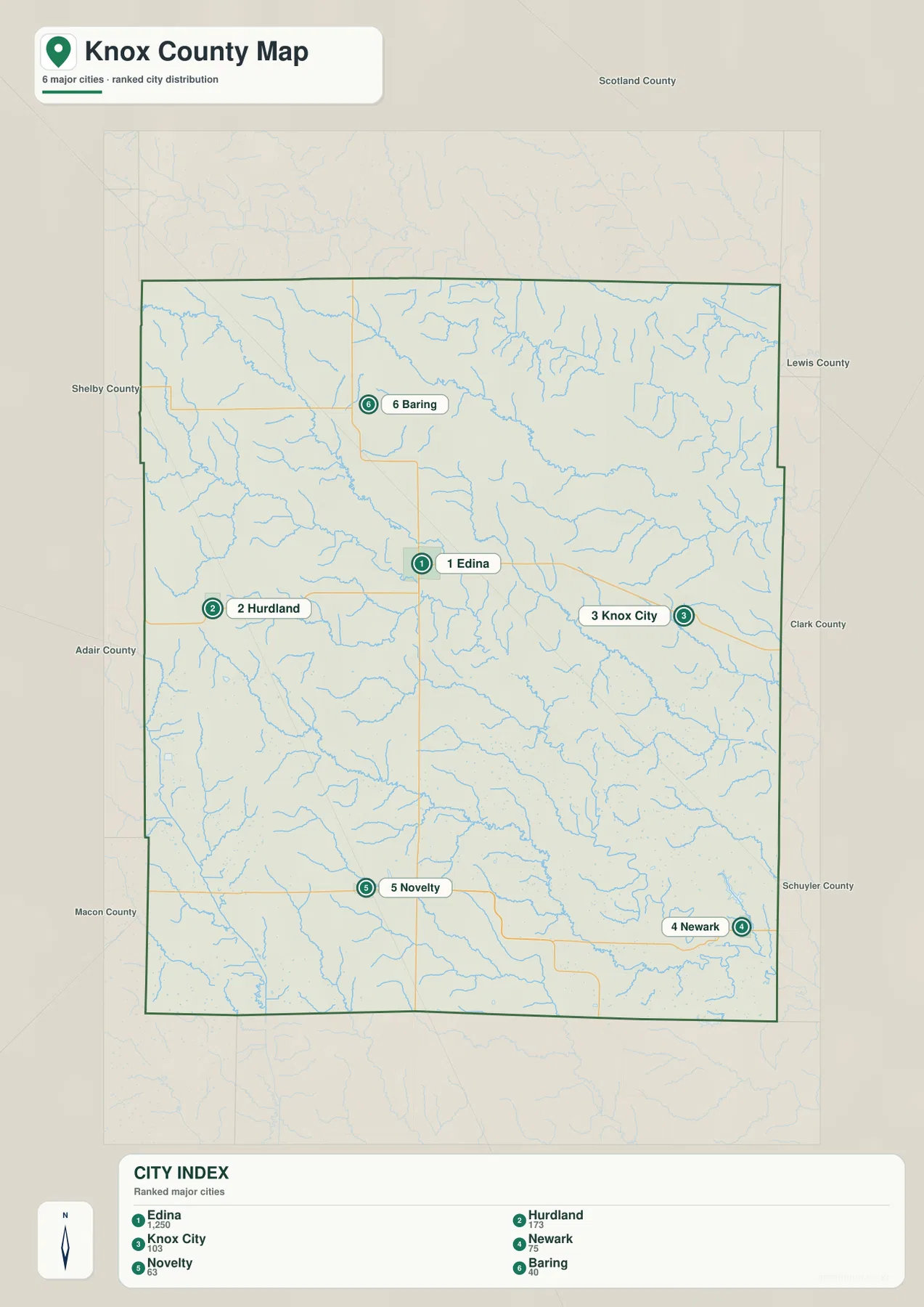
The city layer ranks six major communities
The ranked city map places Edina first, Hurdland second, Knox City third, Newark fourth, Novelty fifth, and Baring sixth. The CITY INDEX displays values of 1,250 for Edina, 173 for Hurdland, 103 for Knox City, 75 for Newark, 63 for Novelty, and 40 for Baring. These values belong to the supplied map dataset and should not be treated as current official population estimates.
The distribution itself is more useful than the raw values. Edina occupies the center, Hurdland the west, Knox City the east, Baring the north, Newark the southeast, and Novelty the south-central area. The numbered markers indicate rank rather than road mileage or travel time.
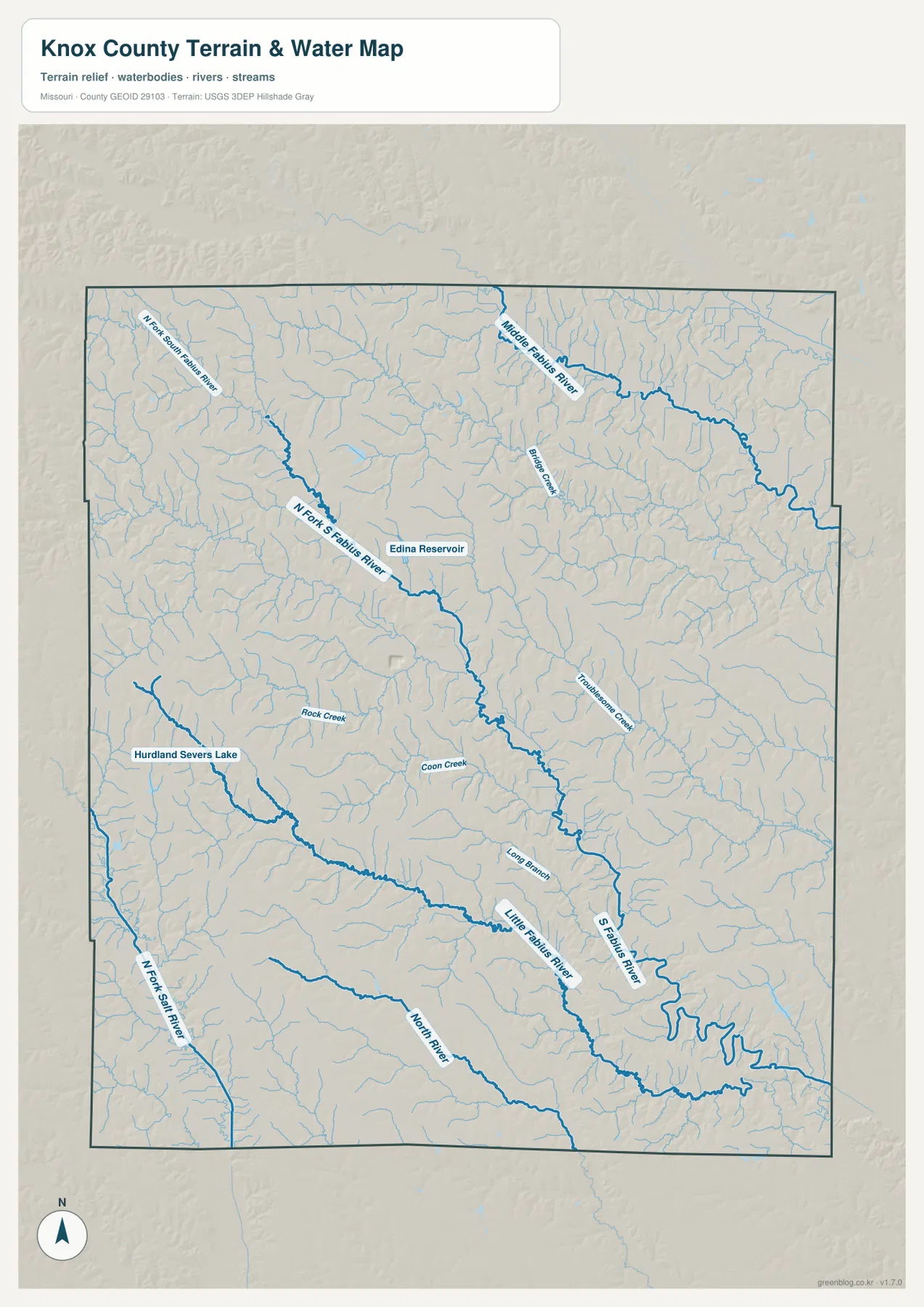
North Fork South Fabius River cuts a long central valley
One of the strongest water features on the terrain-and-water map is the North Fork South Fabius River. It enters from the northwest and continues across the central part of the county toward the southeast, receiving many short tributaries along the way. Edina Reservoir is labeled close to this central drainage.
Coon Creek and Troublesome Creek are among the smaller named streams associated with the same interior landscape. On the elevation map, the river corridor forms a long green lowland bordered by higher yellow and tan ridges. What looks like gently rolling farm country on the road map is therefore divided by a much more complex drainage network.
Middle Fabius River creates the northeastern low corridor
Middle Fabius River winds across the northeastern part of Knox County. Buster Creek and many short tributaries drain toward it, creating a broad lower corridor between Baring and the eastern side of the county. The river is especially useful for understanding the terrain north and east of Edina.
Missouri Department of Natural Resources identifies Knox County as part of the broader North and Middle Fabius watershed system in northeastern Missouri. Those rivers eventually contribute to the Fabius system that reaches the Mississippi River. The supplied water map is intended for geographic reference rather than current river stage, flood forecasting, or legal water-boundary decisions.
South Fabius and Little Fabius shape the southeastern landscape
South Fabius River becomes prominent in southeastern Knox County, where it bends through a broad lower valley. Little Fabius River forms another parallel drainage farther west, and Long Branch and numerous smaller streams divide the ridges between them. Newark and Plevna provide useful town references for this part of the county.
Missouri Department of Conservation’s White Oak Bend Access is reached from Newark and provides public access to the South Fabius River. MDC describes the 160-acre area as mostly timber with additional open land and notes that it provides river access without a boat ramp. This county-specific public site helps connect the map’s South Fabius corridor with an actual recreation and conservation location.
Rock Creek and North Fork Salt River define the western side
Rock Creek is labeled in western Knox County, and Hurdland Severs Lake provides a smaller local water reference near Hurdland. Farther southwest, North Fork Salt River runs along a separate drainage system from the Fabius forks. This part of the county also contains some of the higher terrain shown on the elevation map.
North River appears in the southern interior, with many small tributaries branching through the surrounding hills. Rather than being dominated by a single river, Knox County is divided by several drainage systems that flow in different directions. This is one reason the water layer adds so much detail to the otherwise open agricultural landscape.
Elevation ranges from about 158 to 278 meters
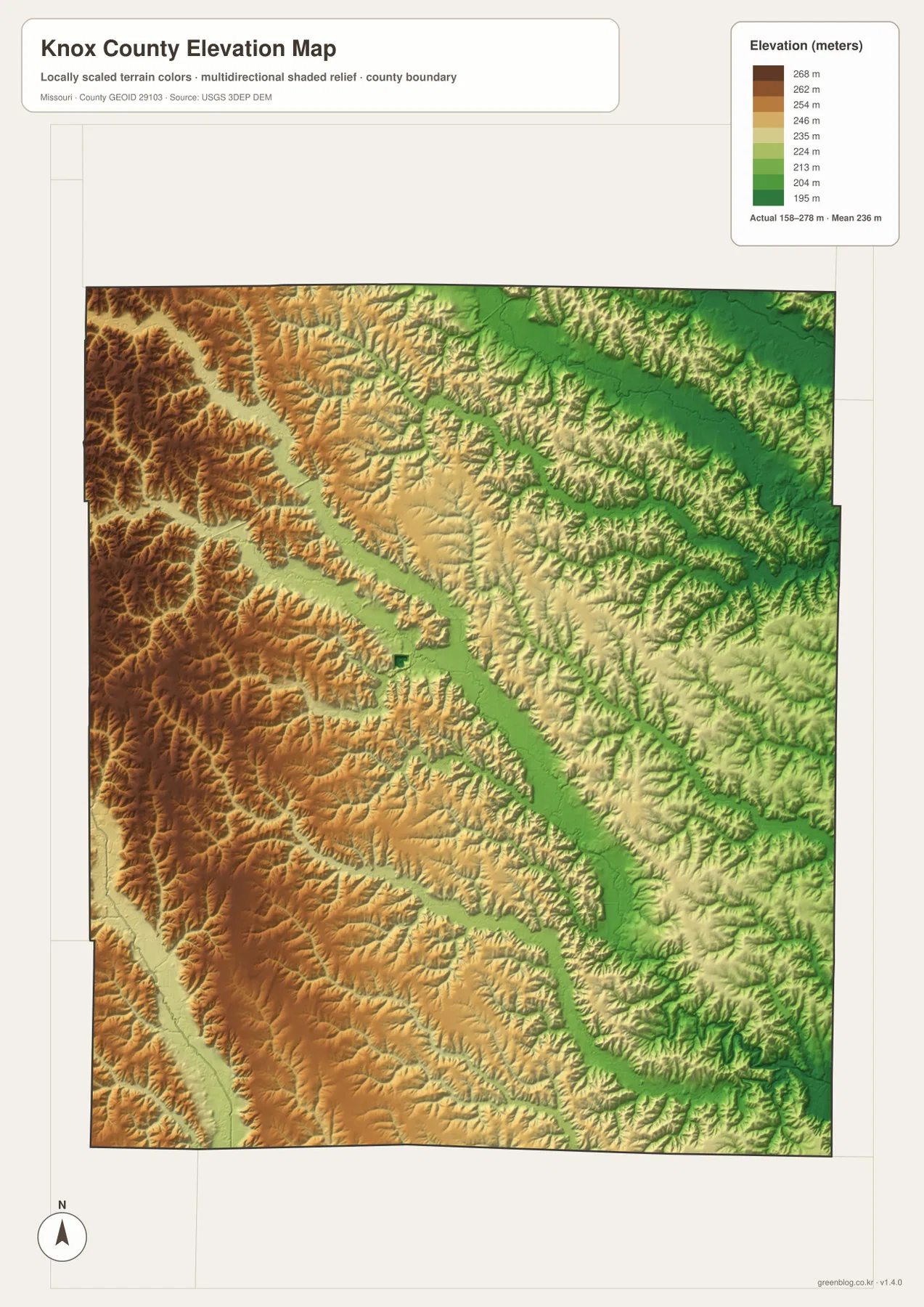
The elevation layer reports an actual mapped range of approximately 158 to 278 meters, with a mean near 236 meters. Much of western and northwestern Knox County appears in tan and brown, indicating higher terrain. The central Fabius corridors and much of the east and northeast are lower and appear in green.
The North Fork South Fabius River creates a particularly clear diagonal low corridor through the center, while Middle Fabius River lowers the northeastern side. South Fabius and Little Fabius produce additional low valleys in the southeast. The map is useful for county-scale terrain comparison but should not be used as survey-grade or engineering-grade elevation data.
Henry Sever Lake Conservation Area adds a county-specific outdoor reference
Henry Sever Lake Conservation Area is an important public landscape in Knox County near Newark. Missouri Department of Conservation describes the area as roughly 1,248 acres of gently rolling upland with grassland, old fields, and oak-hickory woodland. Its centerpiece is the 158-acre Henry Sever Lake, built in 1960.
MDC lists camping, a boat ramp, fishing facilities, trails, and wildlife habitat at the conservation area and gives access directions from Newark using Route KK and Route E. The supplied county map is not an attraction map, but Newark provides a useful geographic anchor for placing this conservation area within southeastern Knox County. Current regulations and seasonal restrictions should be checked on the MDC page before a visit.
Edina is the county seat and service center
Knox County’s official website identifies Edina as the county seat and lists the Knox County Courthouse at 107 N 4th Street. It also notes that the county was organized in 1845 from Scotland County and named for Henry Knox, a Revolutionary War general. These details add local historical context to the central town shown on the map.
University of Missouri Extension maintains its Knox County office at 110 N 4th Street in Edina. The office provides agriculture, 4-H, and community resources, reinforcing Edina’s role as a local service center. Current office hours and contacts should be checked directly on the official pages.
Choosing the right downloadable map
Use the general county map for towns and roads. The ranked city layer is best for comparing Edina, Hurdland, Knox City, Newark, Novelty, and Baring. The terrain-and-water map is useful for the Fabius forks, Rock Creek, North Fork Salt River, reservoirs, and smaller streams, while the elevation layer shows the contrast between higher western uplands and lower central and eastern valleys.
The download ZIP contains high-resolution JPG versions of the same map themes shown on the page. They are useful for enlarging labels, printing a reference sheet, or comparing layers side by side. The files are intended for general geographic reference and do not replace live navigation, flood warnings, legal boundary surveys, or professional elevation measurements.
Frequently Asked Questions
What is the easiest place to use as a reference in Knox County?
Edina is the clearest starting point. It lies near the center of the county, Route 6 and Route 15 are nearby, and it makes the directions to Hurdland, Baring, Knox City, and Newark easy to compare.
Are the values on the city map current population counts?
They should not be treated as current official population estimates. The values beside Edina, Hurdland, Knox City, Newark, Novelty, and Baring belong to the supplied CITY INDEX dataset, while the numbered markers show rank.
What elevation range does the Knox County map show?
The elevation layer shows an actual range of about 158 to 278 meters, with a mean near 236 meters. The west is generally higher, while the central and eastern Fabius River valleys are lower.
Map File Information
Download the map files associated with this page for reference, printing, and compatible visual projects.
- Included Files: Use only the versions confirmed in the article and supplied images
- File Type: Use the confirmed download contents
- Intended Use: Printing, education, presentations, and map-based projects
Related Maps
Sources and references
- Knox County, Missouri – Official Website – Edina courthouse, county history, and local government
- University of Missouri Extension – Knox County – Edina county office and local programs
- Missouri Department of Conservation – Henry Sever Lake Conservation Area – lake, grassland, woodland, and public-use information near Newark
- Missouri Department of Conservation – White Oak Bend Access – South Fabius River access information
- U.S. Census Bureau TIGER/Line Shapefiles – county boundary and road data
- USGS National Hydrography – rivers, streams, and water features
- USGS 3D Elevation Program – elevation data
Green Map creates custom-edited map images using open geographic data sources such as geoBoundaries, Natural Earth, OpenStreetMap, and government open data. These maps are edited visual materials, not raw data files, and are provided for education, documents, presentations, and graphic reference.