Richardson County occupies Nebraska’s far southeastern corner, where Falls City serves as the main urban reference point and the Big Nemaha River crosses the county before reaching the Missouri River near Rulo. This Richardson County Map page combines settlement and road detail with a ranked city view, named rivers and creeks, and elevation shading that separates the higher western hills from the lower eastern river country. High-resolution JPG versions of the maps are available in the ZIP download box below for printing, classroom use, and closer inspection.
Falls City is the easiest place to start. Humboldt lies well to the west, Dawson sits between the two, Verdon and Shubert are farther north, and Rulo occupies the eastern side near the Missouri River. Once those places are familiar, the water and elevation maps make the county’s shape easier to understand because the Big Nemaha River, Muddy Creek, and the lower eastern valleys connect many of the visible features.
Table of Contents
Falls City and the road network across southeastern Richardson County
The general county map makes Falls City the most prominent label and shows several numbered routes meeting or passing nearby, including 73, 8, and 159. West of Falls City, the road network leads toward Salem, Dawson, and Humboldt, while Verdon, Shubert, and Stella lie to the north. Rulo appears close to the eastern boundary, and Barada is farther northeast. The result is a county where important settlements are spread in several directions rather than concentrated along a single straight corridor.
Dawson provides a useful midpoint between Humboldt and Falls City. Verdon sits north of the central road corridor, while Shubert and Stella occupy the northern tier. The map also shows many smaller numbered roads, which help distinguish rural connections without turning the page into a turn-by-turn navigation product. For actual driving, current route conditions and closures should be checked separately because a static county map cannot reflect real-time changes.
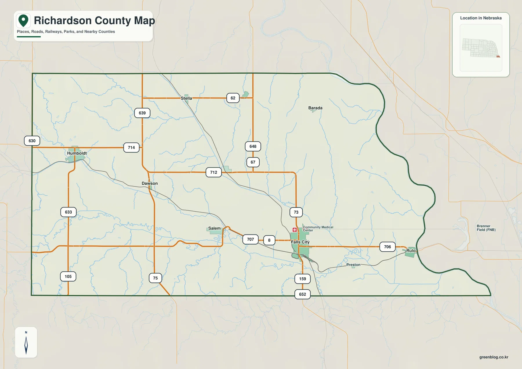
The county outline is also distinctive. The western side is comparatively simple, but the eastern boundary bends repeatedly as it follows the Missouri River area. The southeastern corner narrows and curves around the river landscape rather than forming a neat rectangle. That shape matters when reading nearby place labels, because communities and roads just outside the dark boundary may still appear in the surrounding map for orientation.
This image works well as a first overview because it combines the county boundary, towns, roads, rail corridors, waterways, and nearby features in one frame. It is not intended to replace parcel records, legal boundary surveys, or live navigation. For education, regional reference, or a printed county overview, however, it gives enough context to establish where the main communities sit before moving to the more specialized water and elevation views.
A ranked city view from Falls City to Rulo
The city distribution map simplifies the county by highlighting six major places: Falls City, Humboldt, Shubert, Verdon, Dawson, and Rulo. Falls City is ranked first and placed in the southeast-central part of the county. Humboldt anchors the west, Shubert lies north of center, Verdon and Dawson occupy intermediate positions, and Rulo sits near the eastern edge. Removing much of the road detail makes these relative positions easier to learn quickly.
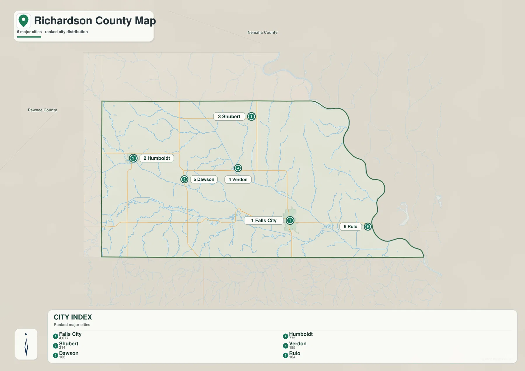
Falls City and Rulo are both in the eastern half, although Rulo is much closer to the Missouri River boundary. Humboldt is separated from them by much of the county’s width, with Dawson roughly between Humboldt and Falls City. Verdon is north of Dawson and Falls City, while Shubert is farther north. This arrangement is useful for describing the county without relying on a dense list of road numbers.
The rank numbers belong to the map’s city index and should not automatically be treated as a current population table. Population estimates and municipal classifications can change, so users who need current statistics should consult the U.S. Census Bureau and local records. The value of this graphic is geographic: it gives a clean picture of which communities are emphasized and where they lie relative to one another.
The official Richardson County website lists Falls City, Humboldt, Barada, Dawson, Rulo, Salem, Shubert, Stella, and Verdon among its cities and villages. The general map shows that broader group, while the ranked city map selects six for a simpler visual comparison. Using both together helps separate a complete local place list from the smaller set of communities emphasized in the index.
North and South Forks joining the Big Nemaha River
The water map explains much of Richardson County’s terrain. In the western half, the North Fork Big Nemaha River and South Fork Big Nemaha River flow eastward and converge before the combined Big Nemaha River continues toward Falls City and the Missouri River. Richardson County’s official history describes the Great Nemaha River as crossing the county from west to east and emptying into the Missouri near Rulo, which matches the broad pattern visible in the supplied map.
Muddy Creek is another major feature. It enters from the north, bends southeast, and joins the Big Nemaha system east of Falls City. Smaller labels include Little Muddy Creek, Whiskey Run, Dry Branch, Whiskey Creek, Hibbard Creek, Early Creek, and Rock Creek. These tributaries create a dense set of narrow valleys, especially in the western and northern parts of the county, rather than leaving the landscape as an uninterrupted plain.
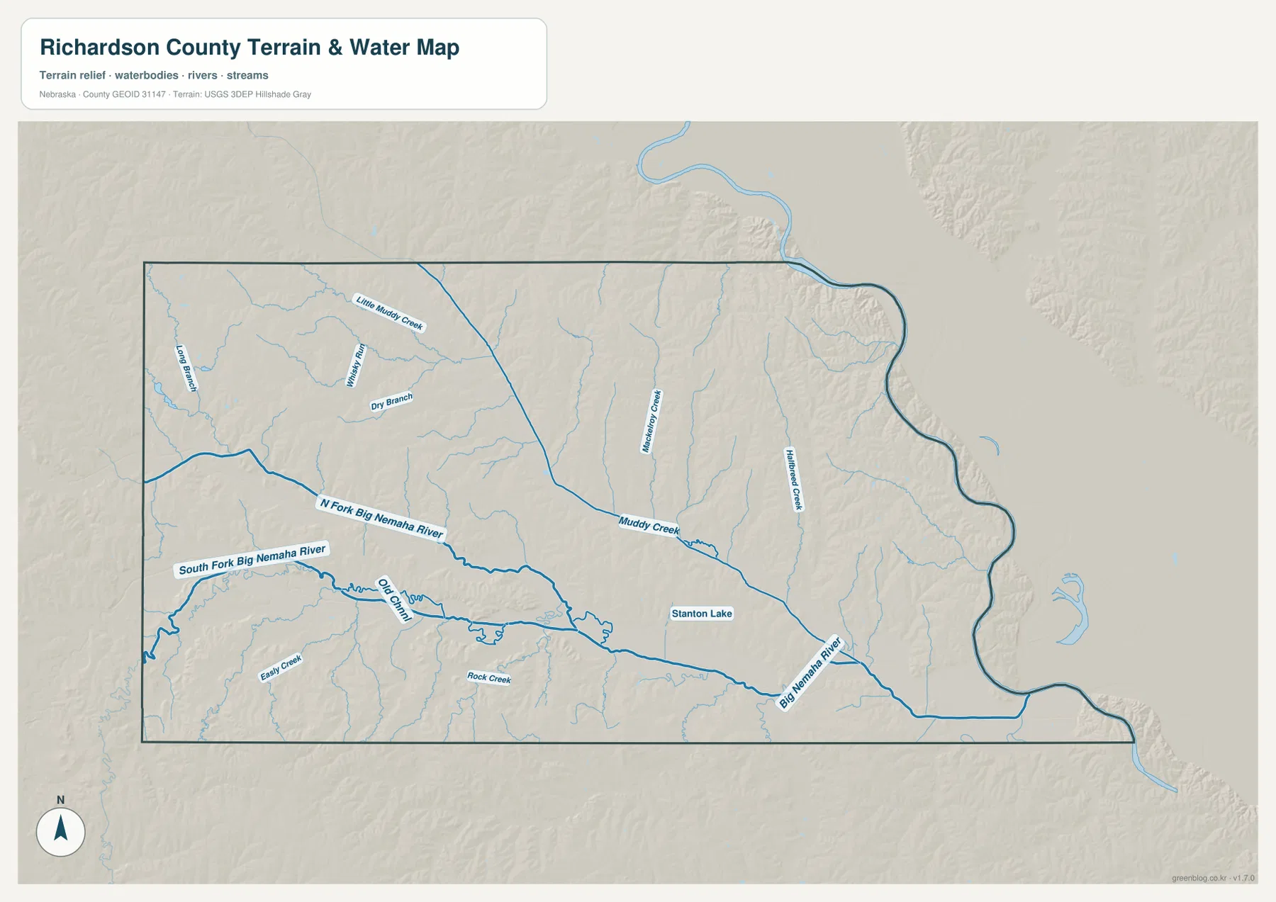
Stanton Lake appears near the central Big Nemaha River corridor, and an Old Channel label marks part of the river landscape farther west. The combined view makes it easier to connect waterways with the towns shown on the other maps. Falls City lies just north of the Big Nemaha River, while the eastern river course heads toward Rulo and the Missouri River boundary.
Blue lines on this reference map show named waterways and general positions; they do not encode current discharge, depth, flood stage, or swimming safety. Floodplain decisions, water access, and regulatory questions require current products from the agencies responsible for those topics. For county geography, though, the map is useful because it places the main river, its forks, Muddy Creek, and smaller tributaries in one consistent frame.
Higher western hills and lower valleys toward the Missouri River
The elevation map shows a strong west-to-east contrast. Brown and tan colors cover much of the western and southwestern uplands, while green bands follow the North Fork, South Fork, Big Nemaha River, Muddy Creek, and the low eastern margin near the Missouri River. The legend reports an actual county elevation range of about 255 to 401 meters and a mean near 312 meters, giving a useful scale for the visible relief.
Humboldt’s side of the county contains broad areas of higher ground cut by numerous creek valleys. South of the Big Nemaha River, the southwestern hills rise again before dropping into smaller drainage lines. In the central county, the main river valley forms a broad green corridor that widens and continues southeast. These differences are much clearer here than on the road map because the color changes emphasize height rather than transportation.
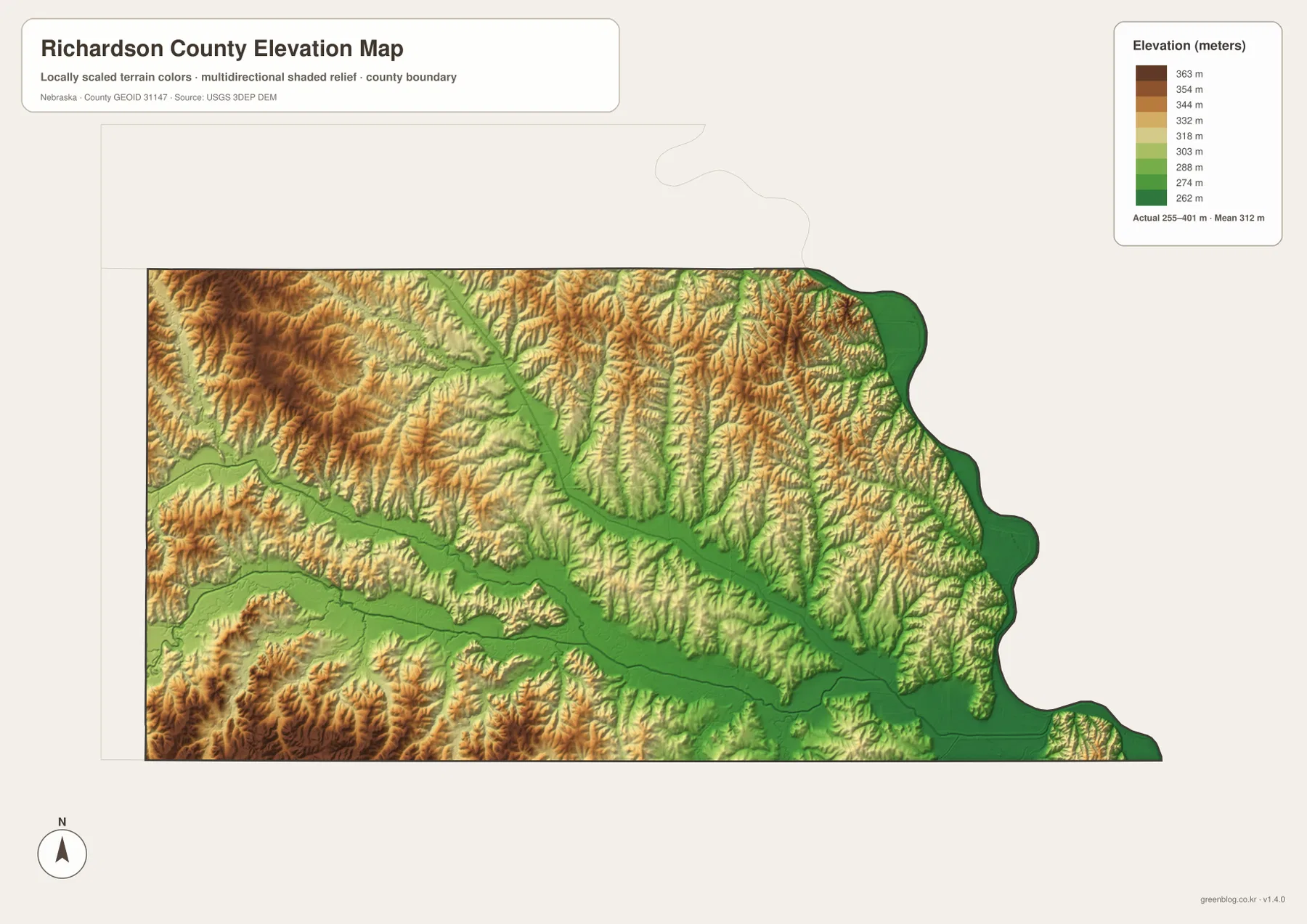
The northeastern part of the county is not uniformly flat either. Muddy Creek and its tributaries cut narrow low corridors through a rolling surface, and the Missouri River edge drops to some of the lowest elevations in the county. The river boundary’s irregular curves and the broad green areas along the east reinforce the connection between the county outline and its low river environment.
This surface is appropriate for county-scale comparison, not site surveying or engineering. A parcel elevation, road grade, construction benchmark, or drainage design requires the underlying USGS data, a professional survey, or another source suited to the specific task. The map is best used to explain broad differences between uplands and valleys and to compare those differences with the water network.
Why Falls City became the county seat
Richardson County was created in the territorial period, and its official history records a long contest over the county seat. Archer was the original seat, but questions about the Half-Breed Tract forced a change. Rulo, Salem, Arago, and Falls City competed for the role until an 1871 election permanently established Falls City as the county seat. That history gives useful context to the modern map, where Falls City remains the most prominent urban label.
Falls City was founded in 1857. Local history describes its early connection with the Lane Trail, later railroad growth, and its development as a commercial center. The current map is not a historical reconstruction, but it does show why Falls City remains a practical reference point today: several roads converge around the city, and the Big Nemaha River passes immediately to the south.
The county itself is named for William A. Richardson, who supported the organization of Nebraska Territory and later served as territorial governor. This origin differs from counties named for rivers or landscape features, even though waterways shaped local settlement and economic activity. Richardson County’s history notes that mills once operated along the Nemaha and Muddy Creek systems, linking the mapped rivers to the county’s early development.
Readers studying change over time should distinguish the current maps on this page from nineteenth-century sources. Present roads, boundaries, and settlement labels reflect modern reference data, while historical routes and former towns require archival maps and records. History Nebraska and the county’s own history pages are useful starting points for that deeper comparison.
Agriculture, rural communities, and creek-cut terrain
The county’s official profile highlights hogs, cattle, corn, alfalfa, wheat, and apples among important agricultural products. The maps on this page do not classify individual farm fields or land cover, so they should not be used to identify the use of a particular parcel. What they do show is the rural setting: towns are widely spaced, smaller roads connect them, and creek valleys cut through higher ground across much of the county.
The contrast is especially clear between the western hills and the eastern river lowlands. Many small streams descend from the uplands toward the Big Nemaha River or Muddy Creek, creating a repeated pattern of ridges and valleys. Farther east, the land drops toward the Missouri River, and the county boundary follows the river’s bends. This makes Richardson County visually different from a simple rectangular plains county.
Falls City is the main center, but Humboldt, Dawson, Salem, Verdon, Shubert, Stella, Barada, and Rulo all help define the county’s settlement pattern. For a local-history project or classroom activity, identifying those places first and then tracing the nearest streams and roads creates a clearer picture than memorizing a list of names without geographic context.
Using the maps for print, classwork, and regional comparison
Start with the general county map when you need an overall view. Find Falls City, move west through Dawson toward Humboldt, then check Verdon and Shubert to the north and Rulo to the east. Once that pattern is familiar, the water map can be used to trace the Big Nemaha River and Muddy Creek through the same area, linking communities with the valleys that shape the landscape.
The ranked city map is better when the only question is where the six emphasized communities lie relative to one another. The elevation map answers a different question by separating the high western terrain from the lower river valleys. Choosing one map for the first question and then using another for supporting detail keeps the page easy to read and avoids mixing unrelated information.
For classroom use, students can locate Falls City, Humboldt, Shubert, and Rulo, trace the Big Nemaha River across the county, and then identify the same river corridor as a low green band on the elevation map. The high-resolution JPG files are useful for printouts or close zooming because smaller creek labels and road numbers remain easier to read than in the WebP previews.
These maps are general geographic references. They do not replace legal boundary records, parcel data, flood maps, surveys, or emergency navigation. Census TIGER/Line files, USGS National Hydrography, and the USGS 3D Elevation Program provide authoritative source data when a more technical or current answer is required.
Frequently Asked Questions
Which map is easiest for comparing Falls City, Humboldt, Shubert, and Rulo?
The ranked city map is the simplest because it removes much of the road detail and emphasizes six communities. Falls City is the main reference point, Humboldt is to the west, Shubert is north of center, and Rulo is near the eastern boundary. Use the general map when you also need roads and smaller place labels.
How does the Big Nemaha River connect with the Missouri River?
The water map shows the North and South Forks joining in the western half of the county, after which the Big Nemaha River continues east past the Falls City area and reaches the Missouri River near Rulo. Muddy Creek and several smaller tributaries also join the system.
Can the elevation map be used for surveying or construction design?
No. It is a county-scale reference for comparing higher uplands with lower river valleys. Survey elevations, road grades, building benchmarks, and engineering design require appropriate USGS source data, professional surveys, or other authoritative technical records.
Map File Information
Download the four high-resolution JPG maps shown on this page for Richardson County in one ZIP archive.
- Included Files: Use only the versions confirmed in the article and supplied images
- File Type: Use the confirmed download contents
- Intended Use: Printing, education, presentations, and map-based projects
Related Maps
Sources and references
County-seat history, communities, local history, and agricultural background come from Richardson County and Falls City sources. Federal references below provide authoritative boundary, hydrography, and elevation data.
- Richardson County – About Our County
- Richardson County – County History
- Falls City – History
- U.S. Census Bureau – TIGER/Line Shapefiles
- USGS – National Hydrography
- USGS – 3D Elevation Program
Green Map creates custom-edited map images using open geographic data sources such as geoBoundaries, Natural Earth, OpenStreetMap, and government open data. These maps are edited visual materials, not raw data files, and are provided for education, documents, presentations, and graphic reference.