Lincoln County stretches across a large part of west-central Nebraska, with North Platte at the meeting place of the North Platte and South Platte river valleys. Interstate 80 and U.S. 30 follow the broad east–west lowland, while U.S. 83 crosses North Platte from north to south. Sutherland, Hershey, Maxwell, and Brady are arranged along the Platte corridor, while Wallace and Wellfleet sit well south of the main river towns. This page connects those communities and roads with the rivers, reservoirs, northern Sandhills, southern canyon country, and an elevation range of about 785 to 1,038 meters. Four original high-resolution JPG maps are also available together in a ZIP file for printing or close inspection. High-resolution map files are available for download in the section below.
The county’s 2026 comprehensive plan describes Lincoln County as centered on the convergence of the Platte rivers, with Sandhills in the north and canyon terrain in the south. That description matches the map set closely. North Platte occupies a wide green lowland, but the terrain becomes higher and more strongly dissected away from the river corridor. The western and southwestern parts of the county are generally higher, while the Platte system descends toward the east.
Table of Contents
North Platte turns I-80, U.S. 30, and U.S. 83 into a simple county-wide framework
North Platte is the natural starting point on the general county map. It is the Lincoln County seat, and county planning material also identifies it as a regional trade and employment center. I-80 passes along the southern side of the city, U.S. 30 follows the Platte valley through the urban area, and U.S. 83 creates the strongest north–south route. Those three roads make North Platte the easiest reference for the rest of the county.
Hershey and Sutherland lie west of North Platte within the same broad valley, while Maxwell and Brady continue the pattern to the east. Sutherland also connects with roads that lead south toward the interior. Wellfleet and Wallace are much farther from the Platte corridor and depend on Highway 23 and local north–south roads for orientation. The settlement pattern is therefore linear along the river valley but much more scattered across the southern uplands.
McPherson County lies to the north, Custer and Dawson counties are on the eastern side, Keith County is west, and Perkins, Frontier, and Hayes counties frame parts of the south. Because Lincoln County covers a large area, those outer boundaries are easier to remember after the central Platte corridor has been established.
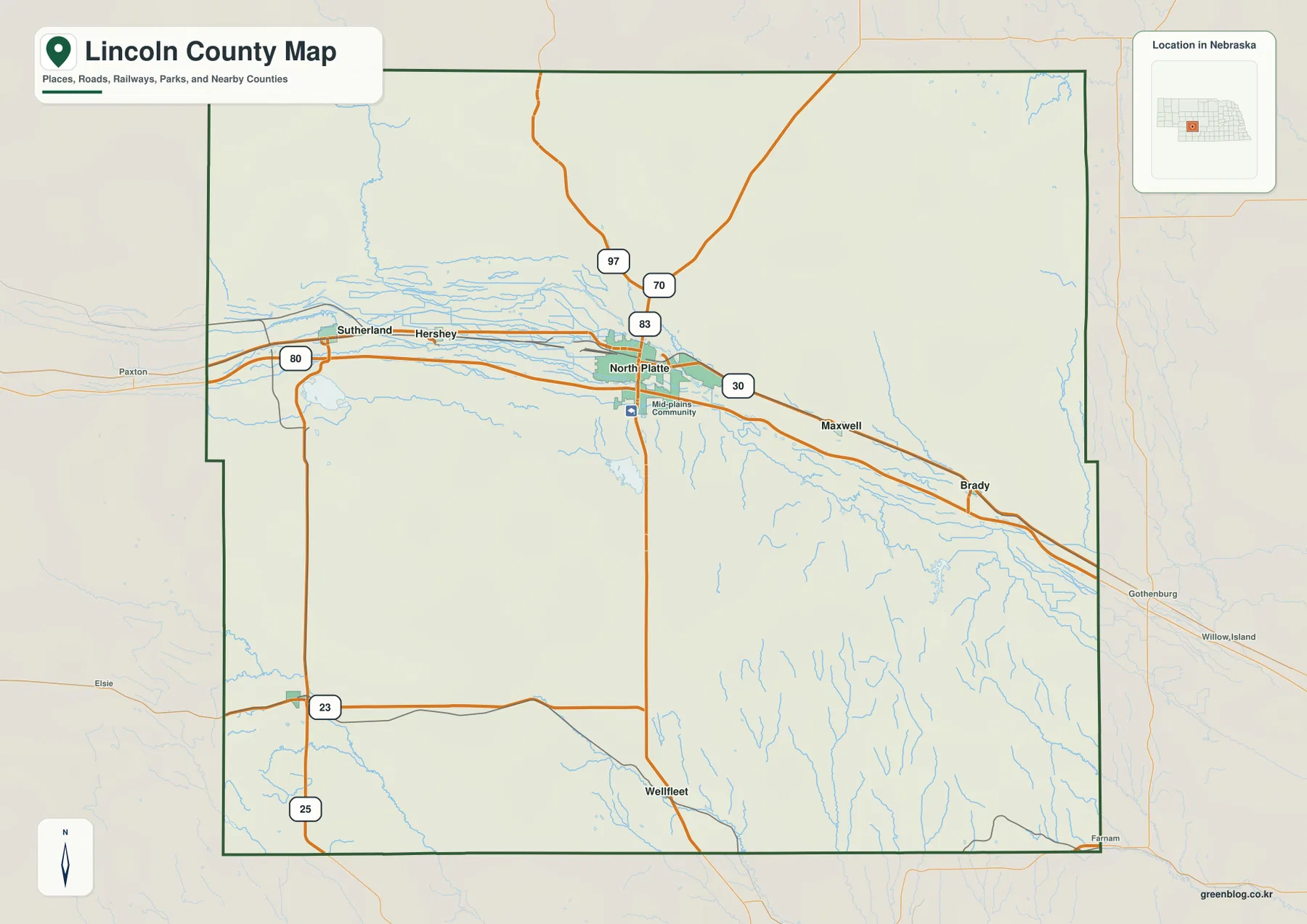
The ranked city map shows how strongly settlement follows the Platte corridor
The supplied city-distribution graphic ranks North Platte first, followed by Sutherland, Hershey, Brady, Wallace, and Maxwell. Its printed index values are 22,831 for North Platte, 1,209 for Sutherland, 724 for Hershey, 477 for Brady, 266 for Wallace, and 174 for Maxwell. These figures belong to the map and are best treated as reference values rather than current official population counts; recent Census or county data should be used when the latest population is required.
Five of the six ranked communities are closely connected to the Platte valley. North Platte sits in the middle, Sutherland and Hershey are to the west, and Maxwell and Brady lie to the east. Wallace is the major exception, occupying the southwestern interior. That contrast makes the county’s settlement geography easy to understand: most larger places use the broad river lowland, while the southern uplands remain much more sparsely settled.
Wellfleet is clearly marked on the general county map even though it is not part of the ranked six. Its location south of North Platte helps fill in an area that otherwise looks empty on the city graphic. Using the two maps together gives a more complete picture of both population concentration and rural settlement.
The North and South Platte rivers create the county’s broad central lowland
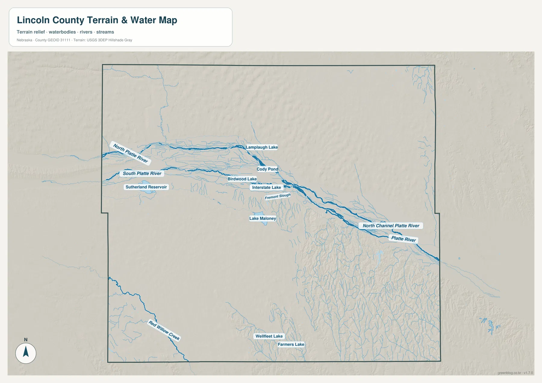
The water map is organized around two major rivers. The North Platte River approaches from the northwest and the South Platte River comes in from the west and southwest. Around North Platte, the two valleys converge and continue east as the Platte River system. Lincoln County’s comprehensive plan uses this convergence as one of the county’s defining geographic features.
The river floor is not a single simple channel. North Channel Platte River, Fremont Slough, and numerous smaller channels and ponds spread across the lowland. This is why the valley appears so wide on both the water and elevation maps. The broad green band is noticeably different from the rolling Sandhills to the north and the dissected terrain to the south.
East of North Platte, the valley continues past Maxwell and Brady toward Dawson County. The river corridor becomes lower toward the county’s eastern edge, while short tributaries cut into the higher ground on either side. The settlement and highway pattern follows this same lowland closely.
Sutherland Reservoir and Lake Maloney add major water landmarks beyond the river channels
Sutherland Reservoir is the largest clearly labeled reservoir in the western part of the map. Visit North Platte describes it as a roughly 3,000-surface-acre lake south of the Sutherland I-80 exit. Its position south of the South Platte River makes it an especially useful landmark for separating the river corridor from the southwestern interior.
Lake Maloney lies south of North Platte and is described by Visit North Platte as a roughly 1,000-acre lake. It provides another strong reference close to the county’s main city without being part of the river’s main channel. Smaller features such as Interstate Lake, Birdwood Lake, Cody Pond, and several sloughs add detail to the North Platte area but do not dominate the county-wide view.
Wellfleet Lake and Farmers Lake appear farther south, while Red Willow Creek cuts through the southwestern corner. These features belong to a very different landscape from the wide Platte lowland. Current water levels, boating access, and recreation conditions can change, so field use should be checked against current management information.
Northern Sandhills and southern canyons frame the Platte valley in different ways
The county’s official comprehensive plan describes Sandhills in the north and canyon country in the south. The shaded-relief maps make that distinction easy to see. North of the Platte corridor, rounded ridges and dune-like forms repeat across the surface. South and southeast of the valley, the terrain is cut by a dense network of narrow drainage lines.
Traveling north from North Platte on U.S. 83, the ground rises out of the river lowland and enters the rolling Sandhills. Heading south toward Wellfleet produces a different texture: the surface is also higher, but tributaries carve longer and more sharply defined valleys into the uplands. The two areas can therefore have similar elevations while looking very different on the terrain map.
This physical contrast also helps explain why the largest communities and transportation routes remain concentrated near the river. The central valley is broader and smoother, while both the northern and southern high country contain more relief and fewer prominent settlements.
Elevation falls from 1,038-meter western high country toward the eastern Platte lowland
The supplied elevation map gives an actual range of about 785 to 1,038 meters, with a mean near 908 meters. The highest brown terrain is concentrated in the west and southwest, while the North Platte and South Platte valleys form a broad green lowland across the middle. The Platte River continues to descend toward the east as it approaches Dawson County.
Higher ground also surrounds the valley on the north side, where the Sandhills become increasingly prominent. South of the river, Wallace and Wellfleet sit within uplands that are dissected by many small valleys. The total mapped difference of about 253 meters is enough to create a strong contrast between the flat river floor and the surrounding high country.
The southeastern canyon terrain is particularly visible on the elevation surface. Narrow green lines branch repeatedly through higher yellow and brown ground, matching the small tributaries on the water map. This is a much more rugged pattern than the broad, smooth Platte corridor around North Platte.
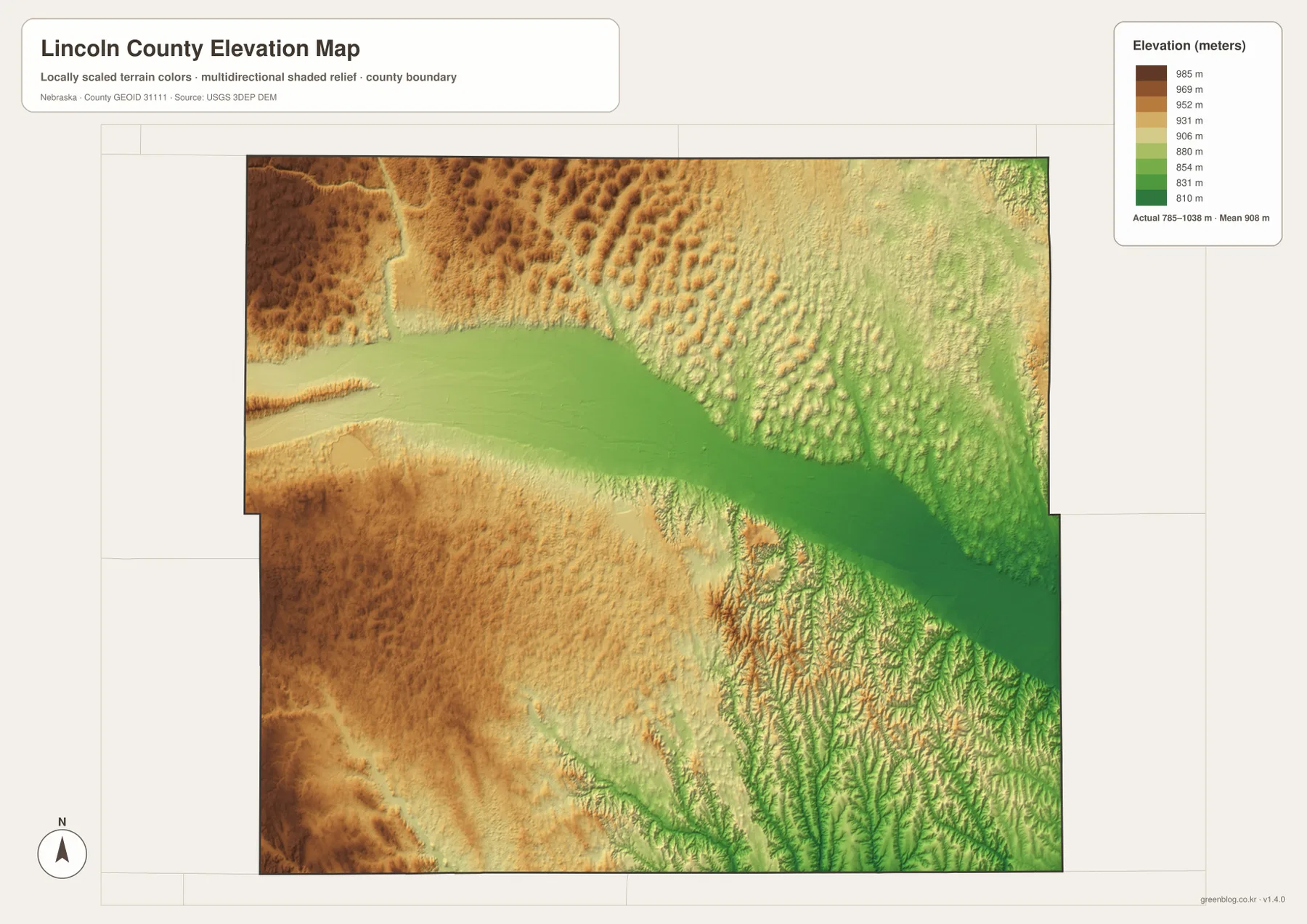
This elevation surface is generalized for county-scale comparison. It is not survey-grade information for a parcel, building site, drainage design, road grade, or engineering project. Those tasks require current detailed elevation data such as the USGS 3D Elevation Program and, where appropriate, professional field measurements.
North Platte’s location explains its role as both county seat and regional center
North Platte is important because several geographic advantages overlap in the same place. The North and South Platte valleys converge nearby, I-80 and U.S. 30 provide east–west access, and U.S. 83 supplies a major north–south route. Lincoln County’s official planning document describes North Platte as a regional trade and jobs center within west-central Nebraska.
The smaller river towns reinforce that pattern. Sutherland and Hershey extend the settlement corridor westward, while Maxwell and Brady continue it eastward. Their locations show how communities repeatedly favored the broad valley floor. Wallace and Wellfleet, by contrast, represent the less densely settled southern interior and rely on a different road and drainage setting.
Thinking of North Platte as the center of a river confluence rather than simply the largest city makes the rest of the county easier to organize. Sutherland Reservoir lies to the west-southwest, Lake Maloney is just south of the city, the Sandhills rise to the north, and canyon-cut uplands spread across the south.
Choose the map according to the detail you need
The general county map is the best starting point for North Platte, Sutherland, Hershey, Maxwell, Brady, Wallace, Wellfleet, I-80, U.S. 30, and U.S. 83. The city-distribution map removes much of the road detail and makes the concentration of settlement along the Platte corridor easier to compare.
For physical geography, the terrain-and-water map provides North Platte River, South Platte River, Sutherland Reservoir, Lake Maloney, Red Willow Creek, and numerous smaller channels. The elevation map answers a different question by showing the high western and southern terrain, the northern Sandhills, and the low central river corridor.
A practical study sequence is to locate North Platte and the highways first, trace the two Platte rivers and reservoirs next, and then compare the same areas on the elevation surface. The WebP images on the page are quick previews, while the original JPG files are better for enlarging labels or printing. Legal boundaries, flood decisions, current road conditions, reservoir access, surveying, and engineering work should use the latest authoritative source for the specific task.
Frequently Asked Questions
Where is the Lincoln County seat?
North Platte is the county seat. Lincoln County’s official materials also describe it as a regional trade and employment center. On the map, it sits where I-80, U.S. 30, U.S. 83, and the two major Platte river valleys come together.
Where do the North Platte and South Platte rivers meet?
Their valleys converge around North Platte and continue east as the Platte River system. The water and elevation maps show this area as a broad low corridor, which also contains much of the county’s largest settlement and transportation network.
Can the 785–1,038 meter elevation range be used for surveying or construction?
No. It is a generalized county-scale range intended for regional comparison. Parcel surveys, construction, drainage design, and road engineering require current detailed elevation data and professional measurements.
Map File Information
The county, city-distribution, terrain-and-water, and elevation maps described on this page are available together in one ZIP file. It contains four original high-resolution JPG maps suitable for detailed viewing and printing.
- Included Files: County map, city-distribution map, terrain-and-water map, elevation map
- File Type: JPG files in a ZIP archive
Related Maps
Sources and references
These official and public sources provide additional context for Lincoln County government, the Platte river convergence, local water features, administrative boundaries, and elevation.
- Lincoln County, Nebraska – About – county seat, area, communities, and local history
- Lincoln County Comprehensive Development Plan 2026 – Platte convergence, Sandhills, and southern canyon context
- Visit North Platte – Water Activities – Sutherland Reservoir and regional water features
- U.S. Census Bureau TIGER/Line – administrative boundary and geographic reference data
- USGS National Hydrography – river and stream data
- USGS 3D Elevation Program – elevation data
Green Map creates custom-edited map images using open geographic data sources such as geoBoundaries, Natural Earth, OpenStreetMap, and government open data. These maps are edited visual materials, not raw data files, and are provided for education, documents, presentations, and graphic reference.