Kimball County occupies Nebraska’s far southwestern Panhandle, where the county meets Wyoming on the west and Colorado on the south. Kimball is the principal community and county seat, with Bushnell to the west and Dix to the east along the U.S. 30 and Lodgepole Creek corridor. Interstate 80 provides the faster east–west route just south of Kimball, while Nebraska Highway 71 runs north–south through the city area. This page connects those roads and communities with Oliver Reservoir, Bennett Reservoir, Lodgepole Creek, and a county-wide elevation range of about 1,347 to 1,654 meters. Four original high-resolution JPG maps are available together in a ZIP file for printing or closer viewing. High-resolution map files are available for download in the section below.
Kimball County is unusually high by Nebraska standards. The county government lists an area of about 952 square miles and identifies Kimball as the county seat, while both county and state tourism sources place Nebraska’s highest point, Panorama Point, in the extreme southwest. The elevation map shows why that location matters: the west and southwest are dominated by high brown terrain, the central Lodgepole Creek valley forms a lower east–west corridor, and the surface continues to descend toward the eastern side of the county.
Table of Contents
Kimball links I-80, U.S. 30, and Highway 71 in the Lodgepole Valley
Kimball is the clearest place to begin on the general county map. U.S. 30 runs from the Bushnell side through Kimball and continues east toward Dix, while Nebraska Highway 71 crosses the city area from north to south. The City of Kimball comprehensive plan identifies I-80, U.S. 30, and Highway 71 as the community’s major transportation routes. It also notes that the U.S. 30 and Union Pacific Railroad corridor provided the framework around which the city developed.
Bushnell lies west of Kimball toward the Wyoming line, and Dix sits to the east toward Cheyenne County. The general map also labels Jacinto farther east and shows a broad grid of county roads reaching into the rural north and south. I-80 and U.S. 30 both serve east–west travel but occupy different alignments and functions, so the county is easier to understand when the interstate, local communities, and older highway corridor are viewed together rather than as a single road line.
The county’s outer position is just as distinctive. Banner County lies to the north and Cheyenne County to the east, while Wyoming and Colorado form the western and southern state boundaries. Near the southwestern corner, Panorama Point is close to the Nebraska–Wyoming–Colorado Three-State Marker. That combination of state lines, high ground, and the central Lodgepole corridor gives Kimball County a geographic setting unlike most of Nebraska’s interior counties.
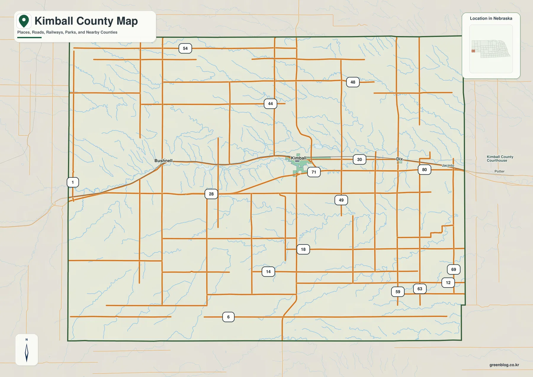
Straight-line spacing puts Dix 9 miles and Bushnell 12 miles from Kimball
The city-connections map uses Kimball as its hub and measures direct distances to the other two ranked communities. Dix is shown about 9 miles east of Kimball, while Bushnell is about 12 miles west. These are straight-line measurements rather than driving distances. Actual road mileage follows U.S. 30 or other local routes, so the graphic is best for comparing direction and relative spacing instead of estimating a trip.
The map numbers Kimball first, Dix second, and Bushnell third. It also prints index values of 2,225 for Kimball, 224 for Dix, and 160 for Bushnell. Those figures belong to the supplied graphic and should not be treated as a live population table; current demographic questions are better checked against recent Census data. Geographically, the message is simple: Kimball is the dominant center, while the two smaller communities occupy opposite sides of the same broad east–west valley.
The arrangement also explains why settlement appears concentrated through the middle of the county rather than distributed evenly from north to south. Bushnell, Kimball, and Dix all sit close to the Lodgepole Creek and U.S. 30 corridor. Large parts of northern and southern Kimball County have many rural roads and tributary valleys but few comparably prominent town labels. Pairing the city map with the county map makes that contrast much easier to see.
Lodgepole Creek ties the central valley to Oliver and Bennett reservoirs
Lodgepole Creek is the strongest continuous water feature on the terrain-and-water map. It enters the county from the west and crosses the central interior toward the east, occupying the same general lowland that contains the major communities and U.S. 30. The creek therefore provides a natural reference for the settlement corridor. Nebraska Game and Parks also recognizes Lodgepole Creek as an important Kimball County stream, including the reach associated with Oliver Reservoir.
Oliver Reservoir lies west of Kimball within the Lodgepole drainage. Nebraska Game and Parks describes the reservoir as roughly 270 acres and notes primitive camping, a fishing pier, and the possibility of low water. Its official birding-site page places the reservoir about eight miles west of Kimball on U.S. 30. On the map it is a relatively small water body compared with major Nebraska reservoirs, but it is one of the clearest named features in the county’s central valley.
Bennett Reservoir appears east of Oliver Reservoir, and the Kimball Canal is labeled nearby. Historic Nebraska water-resource records also identify Bennett Reservoir and the Kimball Canal as part of the county’s storage and irrigation history. The map makes the difference between the winding natural creek and the straighter canal sections easy to recognize. Following these features from west to east provides a simple way to understand how water moves through the lower middle of the county.
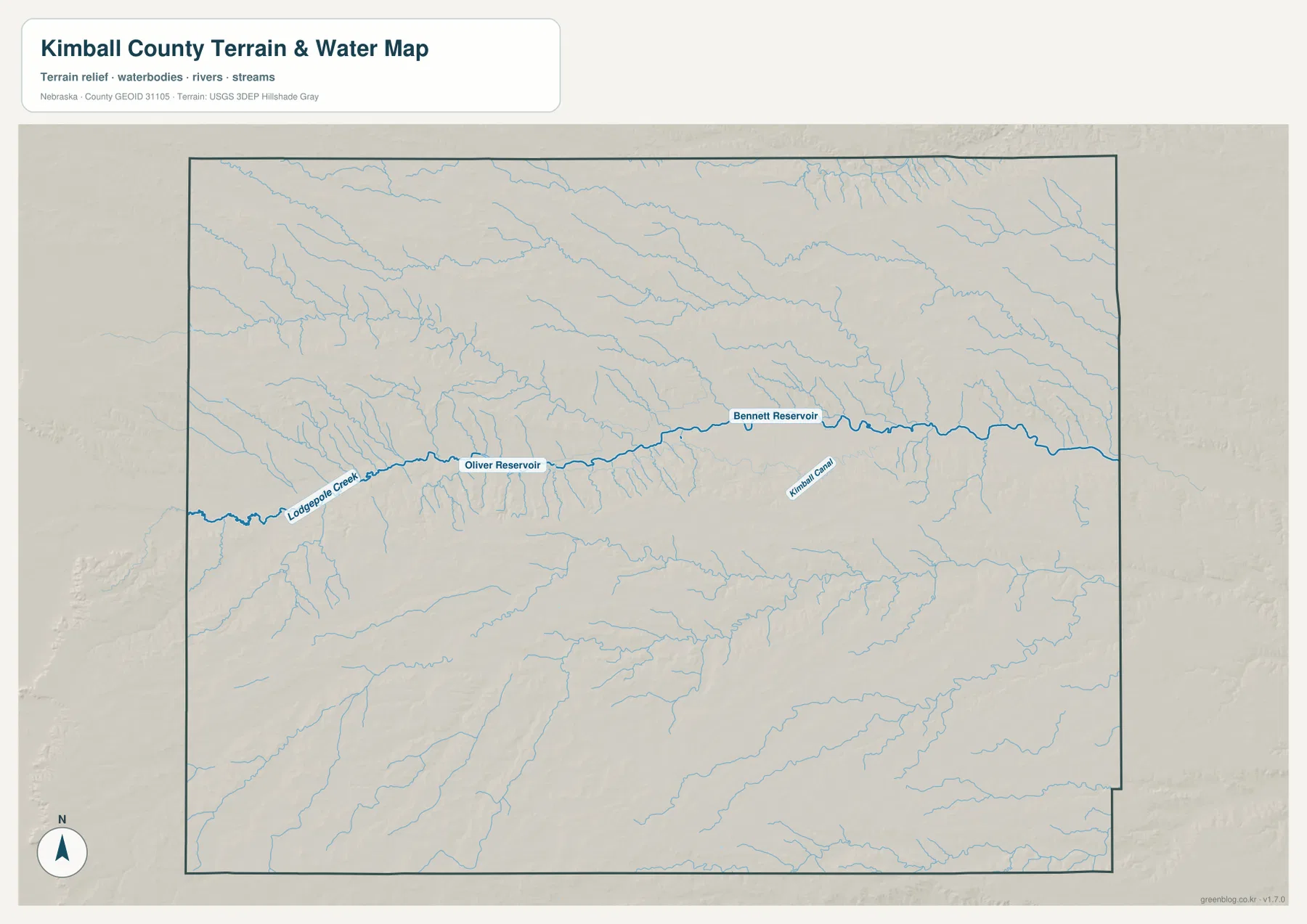
This is a general geographic water map, not a flood, parcel, water-rights, or real-time reservoir product. Water levels and access conditions can change, especially at a reservoir such as Oliver where low water is noted in official recreation guidance. Anyone planning fishing, camping, or field access should check current management information. For map reading, the useful point is the relationship between the Lodgepole lowland and the surrounding higher plains.
Panorama Point explains why the southwest reaches Nebraska’s highest elevation
The elevation map gives an actual county-wide range of about 1,347 to 1,654 meters, with a mean near 1,502 meters. The highest brown and dark-orange terrain is concentrated across the west and southwest, while colors become progressively greener toward the east. The difference between the mapped high and low points is about 307 meters, enough to create a clear regional slope and many deeply cut tributary valleys even though the county remains part of the High Plains.
Panorama Point provides the best real-world reference for the high end of that range. Kimball County and Visit Nebraska identify it as Nebraska’s highest point at 5,424 feet, about 1,653 meters, in the extreme southwestern part of the county. That figure closely matches the map’s maximum of roughly 1,654 meters. Panorama Point is not a sharp mountain summit; it is a high point on broad prairie, which is why the elevation colors and shaded relief are more informative than a conventional mountain symbol.
The central Lodgepole Creek valley forms a long green lowland through the middle of the elevation surface. Small tributaries descend into it from higher ground on both sides. East of Kimball, the overall terrain is lower than in the west but remains cut by many short drainage lines. The result is a county that broadly slopes down from the western high country while still containing local ridges and valleys throughout the interior.
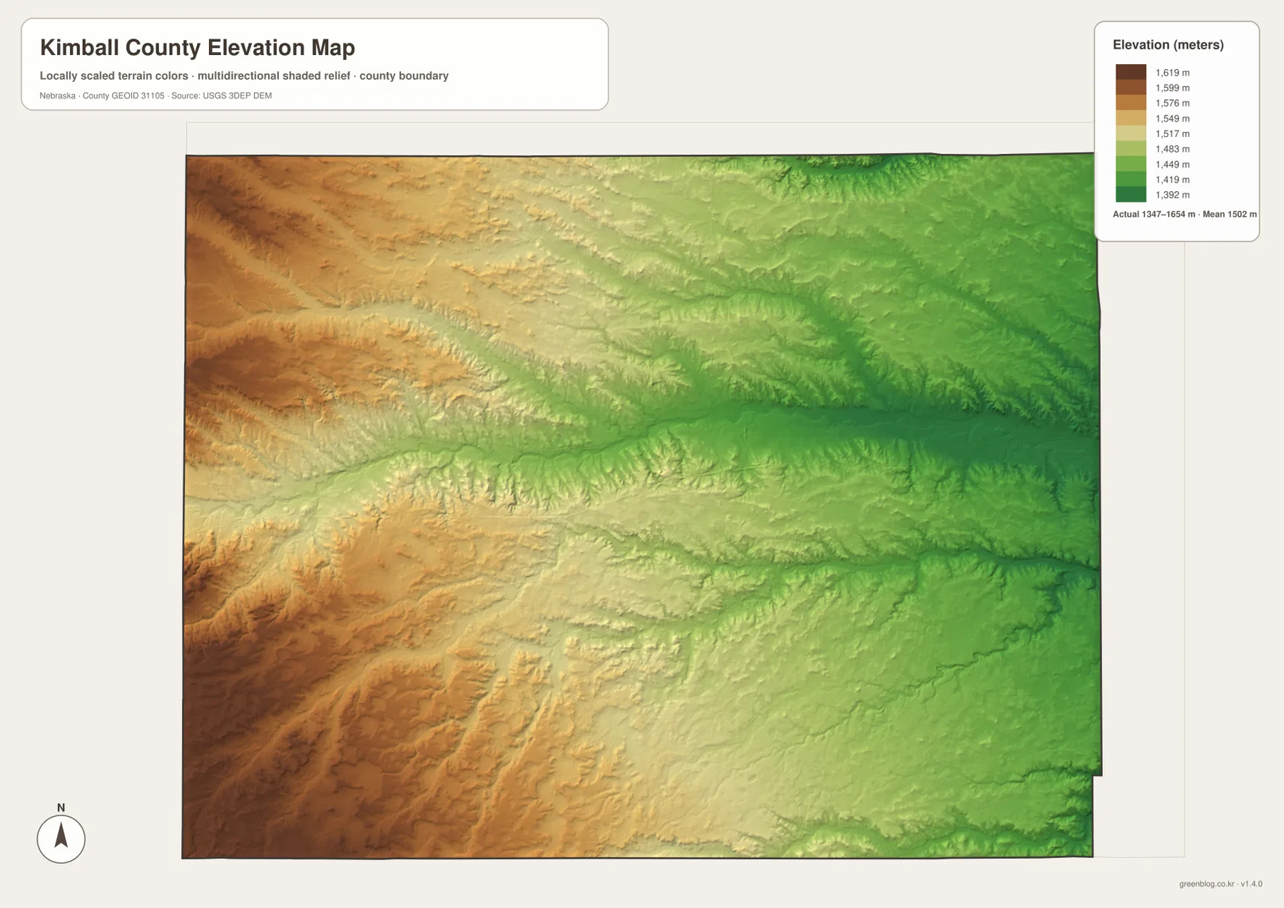
The elevation surface is generalized for county-scale comparison. It is not survey-grade information for a parcel, building site, drainage plan, road grade, wind-energy design, or engineering project. Those tasks require current detailed elevation data such as the USGS 3D Elevation Program and, where necessary, professional measurements. For regional study, however, the 1,347–1,654 meter range makes the high southwest and lower central valley immediately understandable.
The Lodgepole Valley also explains Kimball’s railroad and highway history
Kimball County’s official history says the settlement that became Kimball began around 1870 as the Union Pacific Railroad established facilities in the area. The community was first known as Antelopeville before taking the Kimball name. The City of Kimball comprehensive plan adds that the U.S. 30 and Union Pacific corridor provided the framework for downtown and neighborhood development. The modern maps preserve that pattern: rail, highway, town, and creek all occupy the same general east–west lowland.
The elevation map helps explain why that corridor matters. Land immediately north and south of the city rises into rolling uplands, while Lodgepole Creek marks a relatively lower route through the center. Modern I-80 handles much of the fast east–west traffic, but U.S. 30 still makes the relationship among Kimball, Bushnell, and Dix especially clear. The county’s transportation geography therefore combines an older valley corridor with a newer interstate route running through the same broad region.
Panorama Point represents a completely different part of the county. It lies far southwest of the main settlement corridor near the three-state corner and stands at the top of Nebraska’s elevation range. Putting the city and elevation maps side by side shows that the county’s principal population center is not at its highest point. Kimball developed in the more accessible Lodgepole Valley, while the greatest elevations remain in sparsely settled western and southwestern high country.
Oliver Reservoir and Panorama Point provide two very different western landmarks
Oliver Reservoir is one of the easiest named landmarks west of Kimball. Nebraska Game and Parks places it about eight miles west of the city on U.S. 30 and describes fishing, primitive camping, and other outdoor use. Its position within the Lodgepole drainage makes it useful for locating the lower valley between Kimball and the Wyoming side of the county.
Panorama Point lies much farther southwest and represents the opposite terrain condition. Kimball County places the high point about 33 miles from Kimball near the extreme southwestern corner, close to the Three-State Marker. Even if the point itself is not emphasized by a large symbol on the county map, the elevation map makes the surrounding high country obvious through its dark brown colors.
Comparing the two landmarks prevents the western half of the county from being treated as one uniform high plateau. Oliver Reservoir occupies the lower Lodgepole Creek environment, while Panorama Point sits hundreds of meters higher on the southwest upland. The water and elevation maps therefore complement one another particularly well in this part of the county.
Choose the sheet according to whether you need roads, settlements, water, or relief
The general county map is the best first choice for locating Kimball, Bushnell, Dix, U.S. 30, I-80, Highway 71, and the neighboring state and county boundaries. The city-connections map simplifies the picture and is more useful when the question is how far Dix and Bushnell lie from Kimball in direct distance. Its 9-mile and 12-mile labels should not be interpreted as road mileage.
For physical geography, the terrain-and-water map adds Lodgepole Creek, Oliver Reservoir, Bennett Reservoir, the Kimball Canal, and smaller tributaries. The elevation map removes much of that labeling and emphasizes height, making Panorama Point’s high southwest and the lower central and eastern terrain easy to compare. Tracing Lodgepole Creek on the water sheet and then finding the same green lowland on the elevation surface is an effective way to connect the two.
A practical study sequence is to locate Kimball and U.S. 30 first, trace Lodgepole Creek and the reservoirs on the water map, and then compare the western high country on the elevation map. The WebP images on the page are quick previews, while the original JPG files are better for enlarging labels or printing. These are general-reference products, so legal boundaries, live road conditions, reservoir levels, water rights, surveying, and engineering work should use the latest authoritative source for the specific task.
Frequently Asked Questions
Where is the Kimball County seat?
Kimball is the county seat. The county government identifies it as the administrative center, and the general map shows why it is also the best geographic reference: U.S. 30 and Highway 71 meet in the city area, with I-80 running just to the south.
Are the 9-mile and 12-mile labels on the city map driving distances?
No. They are straight-line distances from Kimball to Dix and Bushnell. Actual driving mileage follows U.S. 30 or other roads and can differ, so current navigation information should be used when planning a trip.
Is Nebraska’s highest point in Kimball County?
Yes. Panorama Point is in the county’s extreme southwest. Kimball County and Visit Nebraska identify it at 5,424 feet, about 1,653 meters, while the supplied elevation map reaches roughly 1,654 meters in the same high western landscape.
Map File Information
The county, city-connections, terrain-and-water, and elevation maps are available together in one ZIP file. It contains four original high-resolution JPG maps suitable for detailed viewing and printing.
- Included Files: County map, city-connections map, terrain-and-water map, elevation map
- File Type: JPG files in a ZIP archive
Related Maps
Sources and references
These official and public sources provide additional context for Kimball County government and history, Panorama Point, Oliver Reservoir, administrative boundaries, waterways, and elevation. The maps on this page are simplified for readable regional reference, so legal, engineering, and current-condition decisions should be checked against the original authoritative datasets and notices.
- Kimball County, Nebraska – About Kimball County – county seat, area, history, and Panorama Point information
- City of Kimball – local information and Lodgepole Valley context
- Visit Nebraska – Panorama Point and Three-State Marker – Nebraska high-point information
- Nebraska Game and Parks – Oliver Reservoir – reservoir location and recreation information
- U.S. Census Bureau TIGER/Line – administrative boundary and geographic reference data
- USGS 3D Elevation Program – elevation data
Green Map creates custom-edited map images using open geographic data sources such as geoBoundaries, Natural Earth, OpenStreetMap, and government open data. These maps are edited visual materials, not raw data files, and are provided for education, documents, presentations, and graphic reference.