Douglas County occupies the eastern edge of Nebraska, where Omaha spreads westward from the Missouri River into a landscape of rolling hills, creek valleys, and reservoirs. The Elkhorn River creates a second broad lowland on the western side near Valley and Waterloo. Between those two river corridors, Papillion Creek tributaries cut through higher terrain, giving the county much more relief than the dense Omaha street grid might suggest. High-resolution map files are available for download in the section below.
This page explains the main communities and roads, the ranked distribution of Omaha, Ralston, Valley, Bennington, Waterloo, and Boys Town, the Missouri and Elkhorn river systems, urban reservoirs, and an elevation range of about 291 to 421 meters. The original high-resolution JPG versions of the supplied maps can also be downloaded together in a ZIP for printing, classroom use, or personal reference.
Table of Contents
Omaha occupies the eastern lowland but extends deep into rolling uplands
Omaha is the Douglas County seat and dominates the eastern half of the map. The Missouri River forms the county’s eastern boundary with Iowa, while the city’s developed area reaches far west across higher ground. Major highways and urban roads converge around Omaha, making the county’s largest population center easy to distinguish from the smaller communities along the Elkhorn side.
Valley and Waterloo sit near the Elkhorn River lowland in the west, Bennington occupies higher northern terrain, Boys Town lies in the central-southwestern metro area, and Ralston is nearly surrounded by Omaha development near the southern edge. The settlement pattern therefore reflects both metropolitan growth and the physical contrast between river plains and dissected uplands.
Douglas County also has a direct connection to Nebraska’s territorial history. History Nebraska identifies Douglas as one of the territory’s original counties, and Omaha has long served as the county seat. The first Nebraska Territorial Legislature met in Omaha in January 1855, and the city remained the territorial capital until the seat of government moved to Lincoln after statehood.
Road density increases sharply from the Elkhorn side toward Omaha
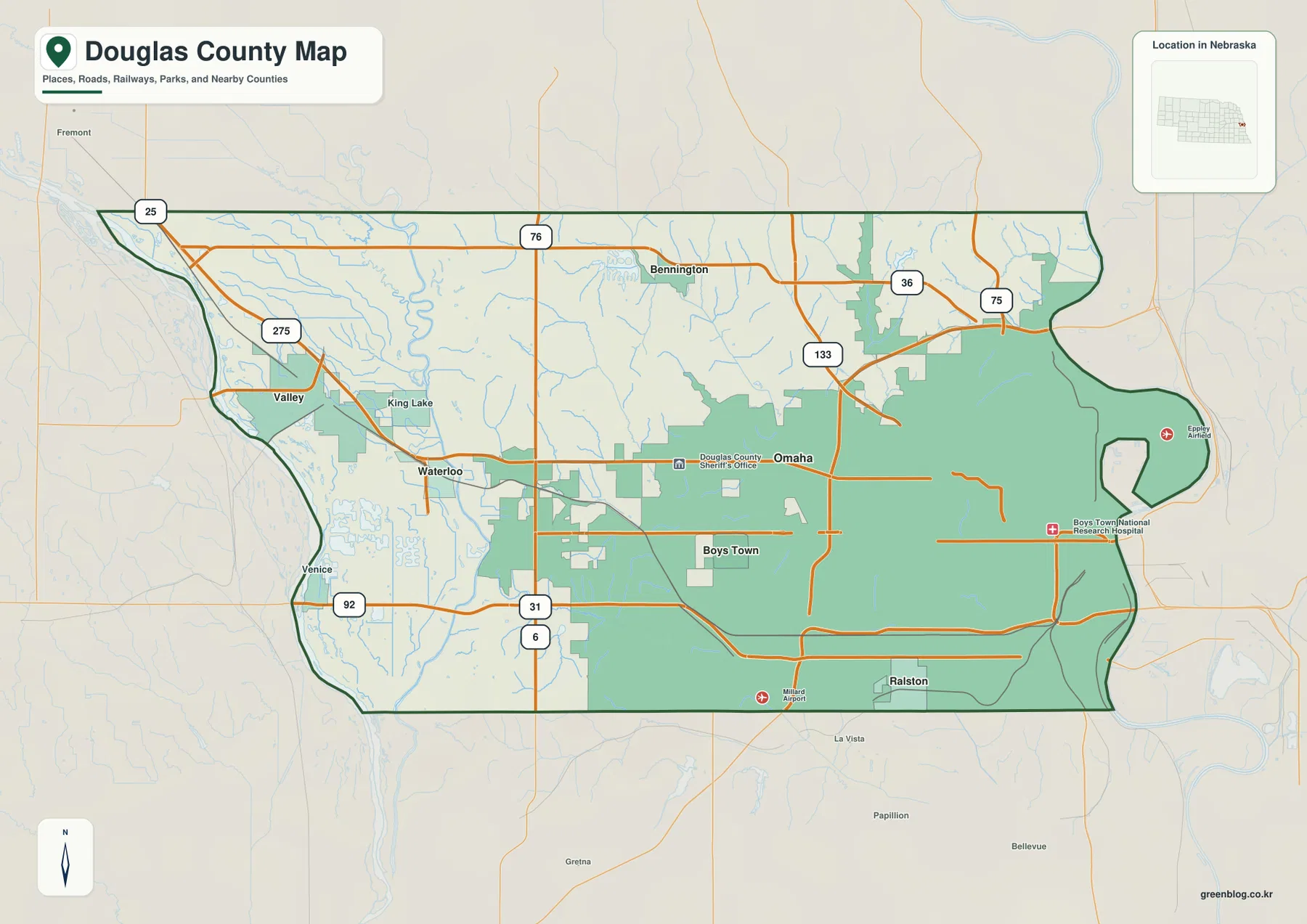
Valley sits near Route 275 on the western side, with Waterloo southeast of it on the Elkhorn plain. Roads are relatively sparse across the rural west, but the network becomes progressively denser toward Omaha. That shift makes the transition from agricultural and suburban land into the state’s largest urban area very clear.
Routes 36 and 133 provide important references across northern and northwestern Omaha, while U.S. 75 runs through the eastern urban area. Roads marked 31 and 6 cross the western metro region, helping orient Valley, Waterloo, and the approaches toward Boys Town. Routes 76 and 25 appear near the northwestern boundary.
The road pattern reflects both development and terrain. Omaha has a dense grid and many major corridors, the Elkhorn plain contains longer direct roads, and the central hills require more bending alignments around creek valleys and reservoirs. The county map is useful for orientation, while live transportation sources remain the better choice for construction, closures, and travel time.
Six ranked communities show how strongly Omaha dominates the county
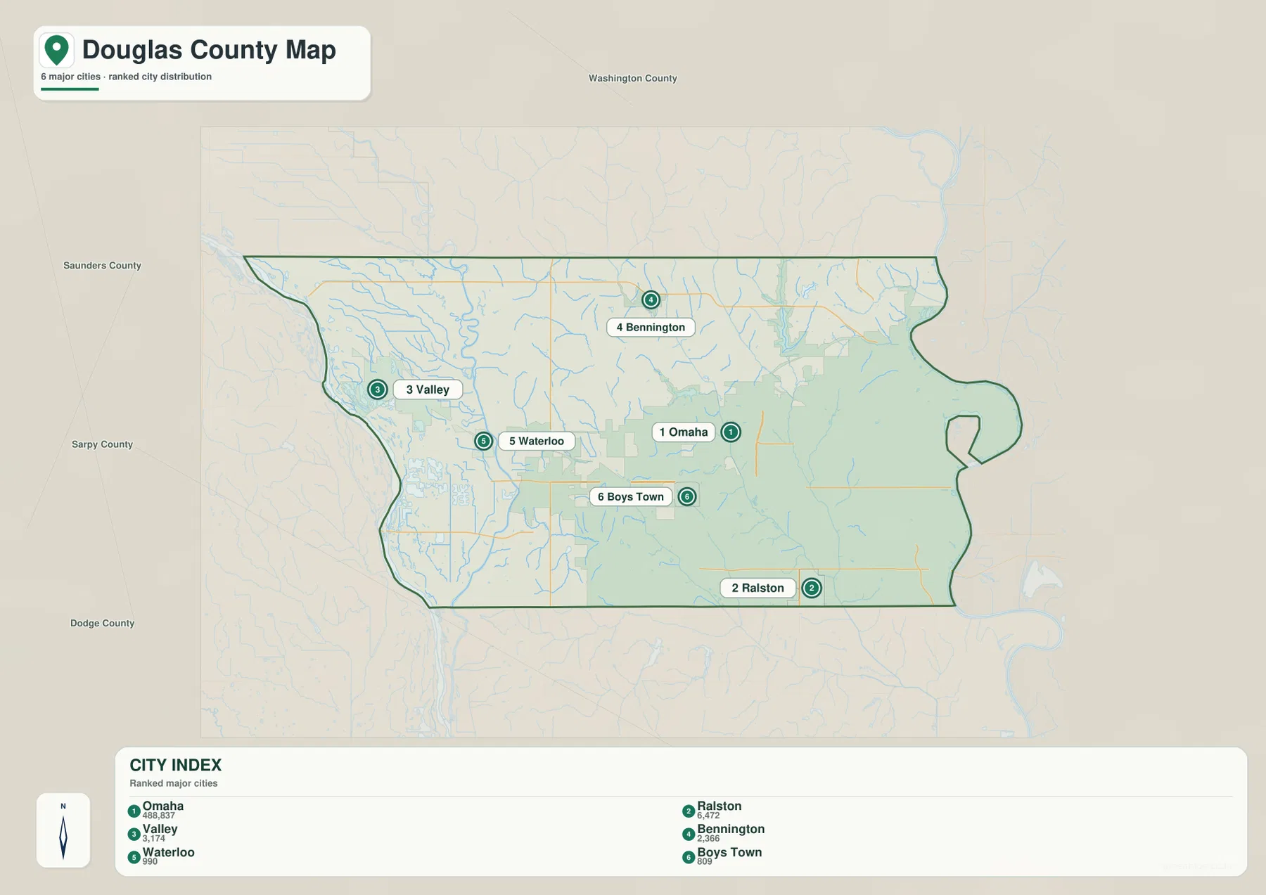
The city distribution map ranks Omaha first by a very large margin, followed by Ralston, Valley, Bennington, Waterloo, and Boys Town. Omaha and Ralston occupy the eastern and southeastern urban area, Bennington lies in the northern suburbs, Boys Town is farther west within the metro, and Valley and Waterloo sit near the Elkhorn River.
No connector lines or mileage labels appear on the supplied city map. The useful comparison is positional rather than numerical. Pairing this view with the road map makes it easier to distinguish the compact Omaha urban area from the smaller communities embedded in western river lowlands and northern uplands.
The values printed on the supplied map are 488,837 for Omaha, 6,472 for Ralston, 3,174 for Valley, 2,366 for Bennington, 990 for Waterloo, and 809 for Boys Town. They belong to the supplied ranked-city graphic rather than a continuously updated demographic table. Current population figures should be checked with the U.S. Census Bureau or local government sources when needed.
Missouri and Elkhorn rivers frame a dense Papillion Creek drainage network
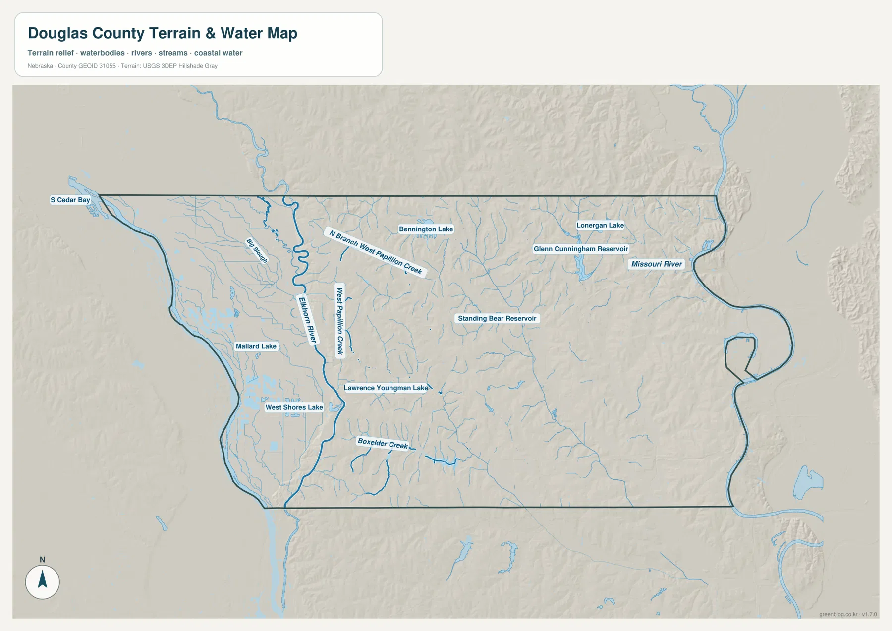
The Missouri River defines the eastern edge, while the Elkhorn River creates a broad western lowland around Valley and Waterloo. Between them, numerous smaller waterways cross the Omaha metropolitan hills. The county therefore contains two major river plains separated by a much more dissected interior.
West Papillion Creek is one of the strongest interior drainage lines, and North Branch West Papillion Creek joins it from the north. Boxelder Creek appears farther southwest, while Big Slough occupies part of the western Elkhorn lowland. These channels are especially clear when compared with the elevation view because they follow lower green valleys through otherwise higher terrain.
Several reservoirs are prominent within or near the Omaha urban area, including Glenn Cunningham Reservoir, Standing Bear Reservoir, Bennington Lake, Lonergan Lake, Lawrence Youngman Lake, West Shores Lake, and Mallard Lake. Papio-Missouri River NRD identifies several Omaha-area reservoirs as part of the broader Papillion Creek flood-reduction system.
This water map is intended for geographic reference. It does not define flood zones, legal water rights, parcel boundaries, current reservoir levels, channel depth, navigability, or public access. Those questions require current information from USGS, Papio NRD, and the responsible local agencies.
Two river lowlands flank a 421-meter interior high zone
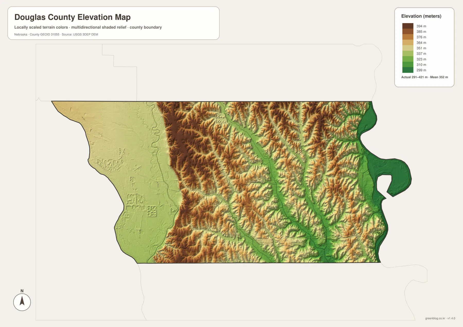
The elevation map reports an actual county-wide range of approximately 291 to 421 meters, with a mean near 352 meters. The lowest dark-green terrain lies along the Missouri River on the east and the Elkhorn River on the west. Higher land occupies much of the interior between those two low corridors.
The highest brown terrain is concentrated through the central-western and northwestern hills. These are not broad flat uplands; Papillion Creek tributaries cut them into closely spaced ridges and valleys. The total relief is about 130 meters, but the transition can happen over a short distance, especially where urban development crosses from creek bottoms onto hilltops.
West Papillion Creek and its branches form green corridors through the interior, while the Missouri side drops again into a much broader river plain. Valley and Waterloo occupy a similarly low setting on the Elkhorn side. This creates a distinctive county profile with low ground on both edges and higher terrain across much of the middle.
The elevation colors are scaled locally for Douglas County and should be used to compare places within this map. Similar shades on another county map may represent different absolute heights. The generalized surface is not survey-grade information for engineering, construction, drainage design, or property work.
Omaha’s county-seat role began with Nebraska Territory
Omaha’s political importance dates to the beginning of Nebraska Territory. History Nebraska says the first Territorial Legislature convened there in January 1855. A second territorial capitol was later built on Capitol Hill, and Omaha remained the seat of territorial government until the capital moved to Lincoln after Nebraska became a state.
The modern map still shows why Omaha was well positioned for growth. It sits directly on the Missouri River, faces the long-established Council Bluffs transportation corridor across the river, and connects westward into the Platte and Elkhorn region. Over time, metropolitan development spread far beyond the early riverfront into the creek-cut hills of central Douglas County.
Reservoirs are part of the metro area’s flood-reduction landscape
Papio-Missouri River Natural Resources District has coordinated flood-reduction work across the Papillion Creek watershed for decades. Its project records identify reservoirs such as Standing Bear and Glenn Cunningham as major flood-control structures within the Omaha area, alongside other lakes across the watershed.
Nebraska Game and Parks also lists Glenn Cunningham Lake and Standing Bear Lake as urban fishing and recreation sites. Their recreational role is visible today, but the county water map should not be used as a current facilities or regulation guide. Boating rules, fishing regulations, water levels, and access conditions should be checked with the responsible agencies before use.
Use Omaha and the two major rivers as three simple map anchors
For basic orientation, start with Omaha and then move west toward Valley and Waterloo, north toward Bennington, and south toward Ralston. Routes 275, 31, 133, and 75 help connect the metro with its smaller surrounding communities. The ranked city map offers a simpler view when minor road detail is not needed.
For physical geography, locate Missouri River on the east and Elkhorn River on the west, then trace West Papillion Creek and its branches through the interior. The elevation map explains the same pattern by showing low green river plains on both sides and higher brown hills between them.
For printing or classroom display, the downloadable high-resolution JPG files preserve more road labels, creek names, reservoir labels, and local terrain detail than the web previews. The county map emphasizes roads and settlements, the city map summarizes ranked communities, the water map shows rivers and reservoirs, and the elevation map highlights the contrast between low river edges and higher interior hills.
Frequently Asked Questions
Does the city map show distances from Omaha to Valley or Bennington?
No. The supplied city map ranks and locates Omaha, Ralston, Valley, Bennington, Waterloo, and Boys Town, but it does not include connector lines or mileage. Use the road map for relative position and a current routing service when actual driving distance is needed.
Where is the lowest terrain in Douglas County?
The Missouri River lowland on the eastern edge and the Elkhorn River plain on the western side contain the lowest broad terrain. The county-wide elevation range is about 291 to 421 meters, with higher rolling ground across much of the interior.
Why are Standing Bear and Glenn Cunningham reservoirs prominent on the map?
Both are large Omaha-area water bodies associated with the Papillion Creek watershed and regional flood-reduction infrastructure, while also serving recreation. The map shows their location but not current water levels, flood status, fishing regulations, or facility conditions.
Map File Information
The ZIP contains the original high-resolution JPG files for the Douglas County boundary and road map, city distribution map, terrain and water map, and elevation map.
- Included Files: Use only the versions confirmed in the article and supplied images
- File Type: Use the confirmed download contents
- Intended Use: Printing, education, presentations, and map-based projects
Related Maps
Sources and references
- Douglas County Nebraska official website
- History Nebraska – Nebraska’s Five Capitols
- History Nebraska – Organization of Nebraska Territory
- Papio-Missouri River Natural Resources District
- USGS National Hydrography
- USGS 3D Elevation Program
These maps are intended for geographic reference. For legal boundaries, land ownership, flood determinations, water rights, road conditions, construction, surveying, or other decisions requiring current authoritative information, consult Douglas County and the responsible state or federal agency.
Green Map creates custom-edited map images using open geographic data sources such as geoBoundaries, Natural Earth, OpenStreetMap, and government open data. These maps are edited visual materials, not raw data files, and are provided for education, documents, presentations, and graphic reference.