Cheyenne County occupies the southern Nebraska Panhandle, with Sidney near the center-south and a broad High Plains landscape stretching east and west. Lodgepole Creek crosses the southern half through the same corridor used by the railroad and U.S. 30, while higher ground dominates the west and southwest. Gurley and Dalton lie north of Sidney, Potter is to the west, and Lodgepole sits farther east along the creek valley. High-resolution map files are available for download in the section below.
This page explains the road network and county boundary, straight-line city connections from Sidney, the Lodgepole Creek system and other named streams, and an elevation range of about 1,126 to 1,440 meters. The original high-resolution JPG versions of the supplied maps can also be downloaded together in a ZIP for printing, classroom use, or personal reference.
Table of Contents
Sidney combines the county’s administrative, railroad, and highway geography
Sidney is the Cheyenne County seat and the best place to begin reading the map. The county government’s official site is based there and lists Dalton, Gurley, Lodgepole, Potter, and Sidney as the principal incorporated communities. Sidney sits slightly south of the county’s center, where major roads and rail lines converge near the Lodgepole Creek valley.
Morrill County lies to the north, Garden County to the northeast, Deuel County to the east, and Banner and Kimball Counties to the west. Cheyenne County now covers about 1,196 square miles, but History Nebraska records that its original 1870 territory was far larger and later supplied land for several neighboring counties, including Kimball, Banner, Scotts Bluff, Deuel, Morrill, and Garden.
The location of Sidney is also tied to the railroad era. City of Sidney and History Nebraska sources say Union Pacific reached the area before the county was organized, and Sidney Barracks was established in 1867 to protect railroad workers. The post later became Fort Sidney, and Sidney became the county seat when Cheyenne County was organized in 1870.
U.S. 30 and the railroad share the Lodgepole corridor through the south
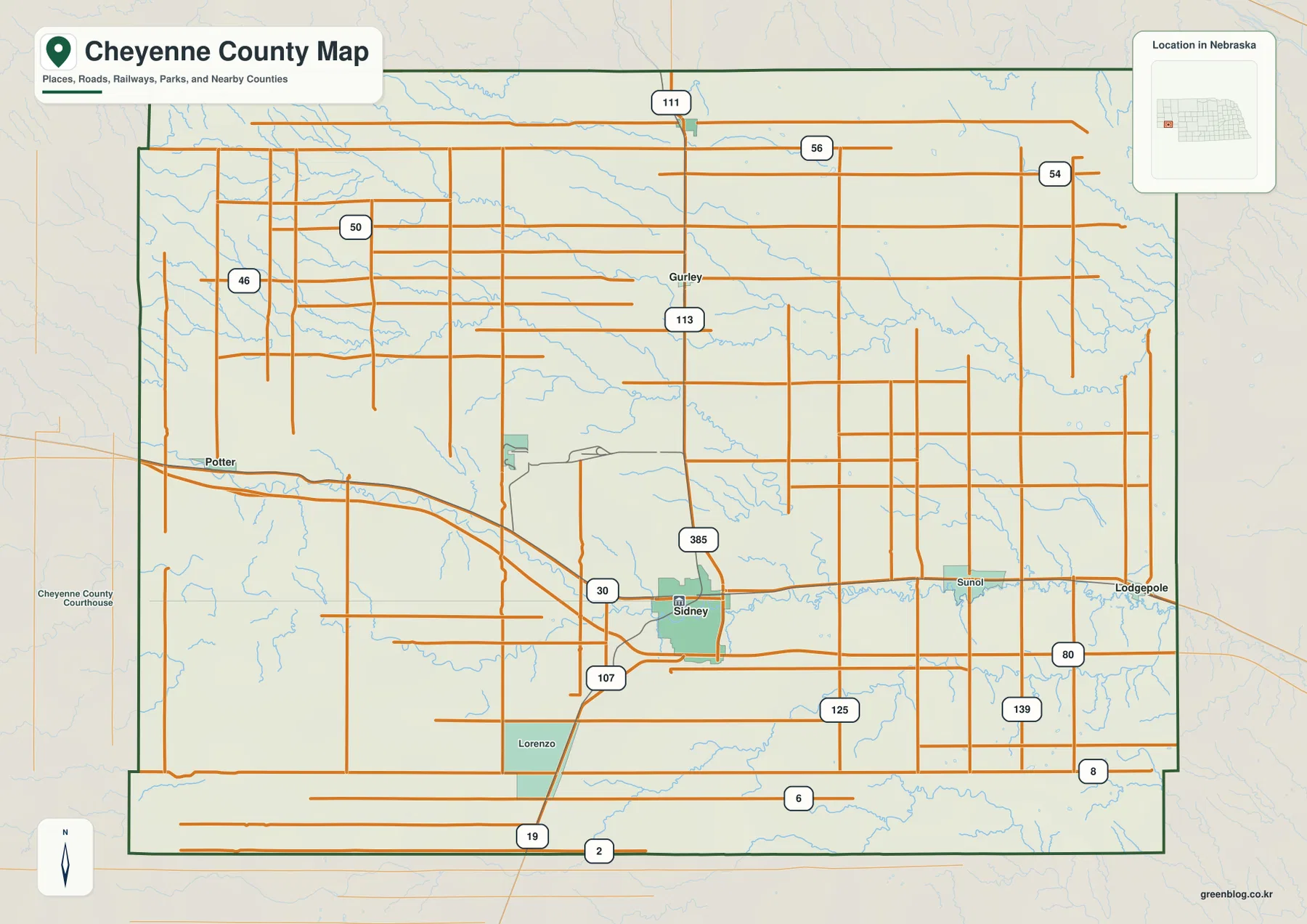
The clearest east-west transportation line follows the lower part of the county. U.S. 30 and the railroad run through the Lodgepole Creek corridor, linking Potter on the west side with Sidney, Sunol, and Lodgepole farther east. The relationship is especially easy to see because the road, rail line, towns, and creek all occupy the same broad lowland.
U.S. 385 runs north from Sidney toward Gurley and beyond, while local routes marked 107, 125, and 139 serve the southern interior. In the north, routes 111 and 113 help locate Dalton and Gurley. Potter and the western farm country are also served by roads marked 46 and 50.
Roads are generally long and direct across the open High Plains, but the western uplands and deeply cut stream valleys create local changes in alignment. The map is useful for county-wide orientation; construction, closures, surface conditions, and actual travel time should be checked with current Nebraska transportation information.
Four direct-distance lines show Sidney’s role as the local hub
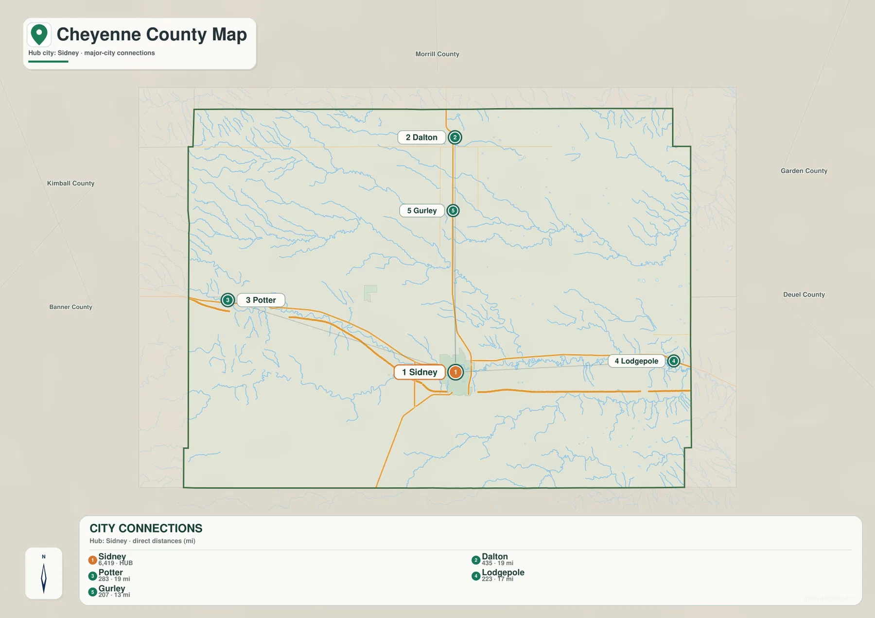
The city-connection map uses Sidney as the hub. It shows approximately 13 straight-line miles to Gurley, 17 miles to Lodgepole, 19 miles to Dalton, and 19 miles to Potter. These are direct point-to-point measurements rather than road mileage, so practical driving distances will vary with the route.
Gurley and Dalton lie north of Sidney, Potter is west-northwest, and Lodgepole is east. Because the four destinations spread in different directions, the map makes Sidney’s central service role clear without the clutter of the full road network. Lodgepole is also easy to remember because the community shares its name with the creek and sits in the same east-west valley.
The ranked values printed on the city map place Sidney first, followed by Dalton, Potter, Lodgepole, and Gurley. Those figures belong to the supplied comparison graphic rather than a continuously updated demographic table. Current population figures should be checked with the U.S. Census Bureau or another official source when needed.
Lodgepole Creek forms the strongest water corridor across the county
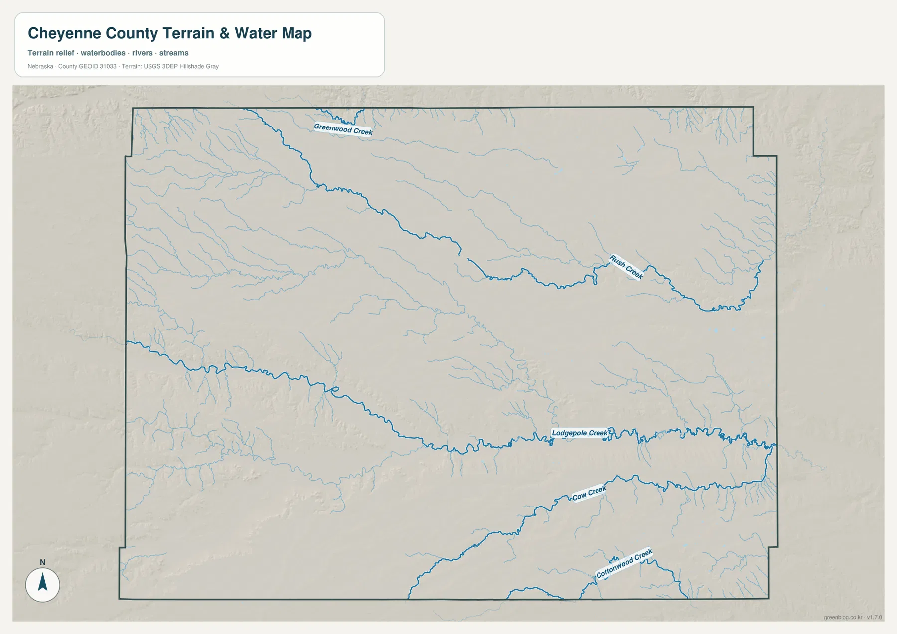
Lodgepole Creek is the most important water reference on the map. It enters from the west, crosses the south-central county, passes close to Sidney, and continues east through the Sunol and Lodgepole area. The railroad and major roads follow the same low corridor, making the creek useful for understanding both physical geography and transportation.
Farther north, Greenwood Creek begins in the northwest and continues across the upper interior. Rush Creek becomes prominent toward the east, with numerous short tributaries descending from the surrounding uplands. On the elevation view, this drainage also forms a lower green corridor through otherwise higher terrain.
South of Lodgepole Creek, Cow Creek runs eastward across the lower interior, and Cottonwood Creek appears closer to the southern edge. Cheyenne County does not have the dense lake systems seen in some Sandhills counties; instead, its water map is dominated by long stream valleys that generally descend from the higher west toward the lower east.
This water map is intended for geographic reference. It does not establish flood zones, legal water rights, parcel boundaries, stream depth, navigability, or public access. Those questions require current information from USGS and the responsible local or state agencies.
The county drops more than 300 meters from west to east
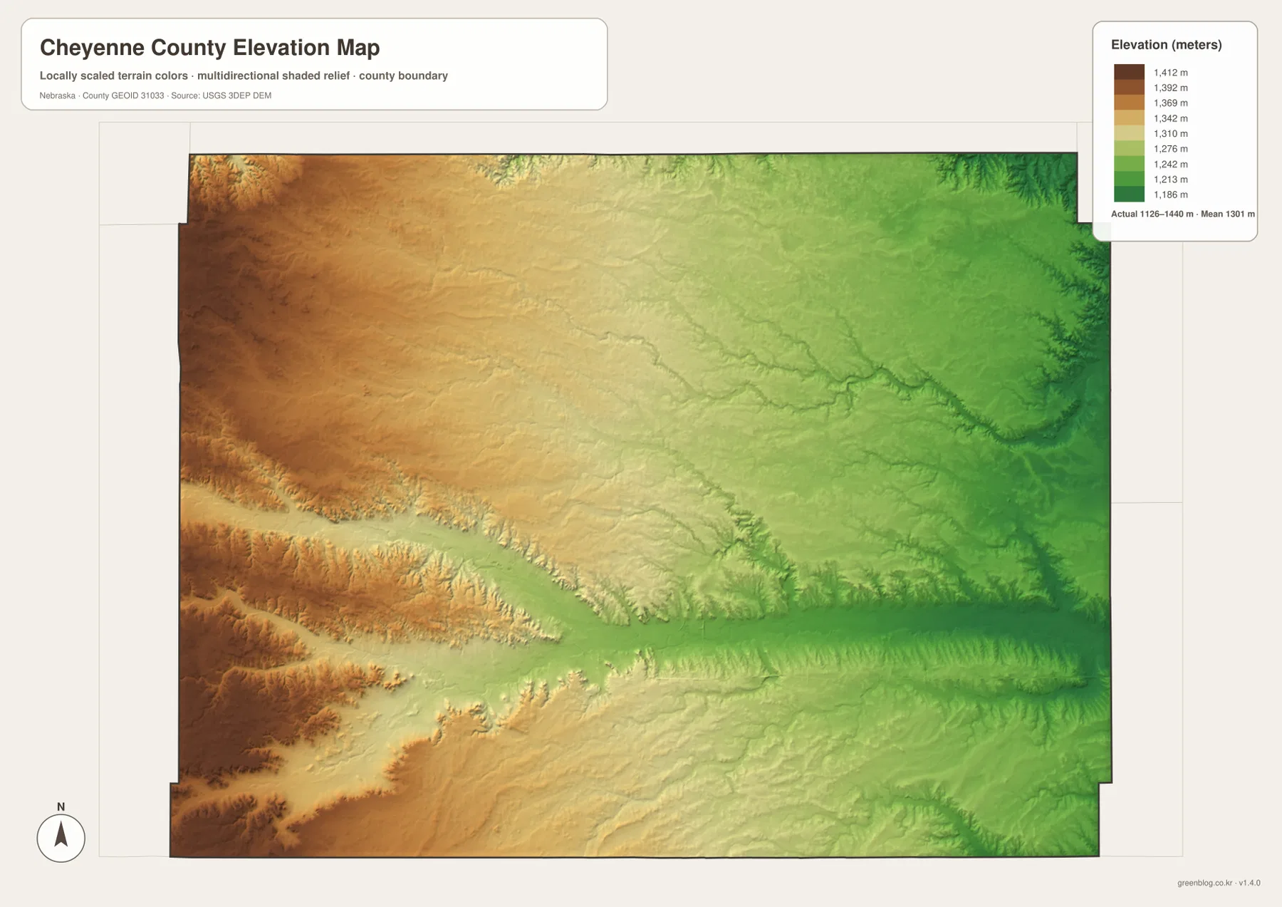
The elevation map reports an actual county-wide range of approximately 1,126 to 1,440 meters, with a mean near 1,301 meters. The highest brown terrain covers much of the west and southwest, while yellow and green colors become more common toward the east. The county therefore has a broad west-to-east descent of more than 300 meters.
Lodgepole Creek forms the most obvious low corridor across the southern half. In the west it cuts between higher uplands, then broadens through the Sidney area and continues toward the eastern boundary. Potter, Sidney, Sunol, and Lodgepole all sit close to this lower route, which helps explain why transportation and settlement concentrated there.
Greenwood and Rush creeks carve another lower path across the north, and the northeastern corner contains especially pronounced drainage incisions. Cow Creek and Cottonwood Creek create similar but smaller valleys in the south. The county is not mountainous, yet the repeated uplands and stream-cut corridors give the terrain much more structure than a flat plains label suggests.
The elevation colors are scaled locally for Cheyenne County and should be used to compare locations within this map. Similar shades on another county map may represent different absolute elevations. The generalized surface is not survey-grade information for engineering, construction, drainage design, or property work.
Sidney grew where railroad history and the Lodgepole valley came together
Sidney was founded in the railroad era. Local and state historical sources say Union Pacific established the town in 1867, while a military post first called Sidney Barracks was created to protect railroad workers. It later became Fort Sidney and remained active until 1894.
When Cheyenne County was officially organized in 1870, Sidney became the county seat. During the Black Hills gold rush, the town also served as an important staging point for northbound traffic. Later the Lincoln Highway and modern I-80 continued the area’s long transportation role. The present map still concentrates U.S. 30, U.S. 385, rail lines, and Lodgepole Creek around Sidney.
Following Lodgepole Creek ties the towns, roads, and relief together
For a first look at Cheyenne County, trace Lodgepole Creek from the western edge toward Sidney and then east through Sunol and Lodgepole. Potter lies near the western part of the same corridor, and both the railroad and U.S. 30 stay close to the valley for long stretches. This single feature explains a surprising amount of the county’s settlement pattern.
From Sidney, U.S. 385 and Route 113 provide a second reference north toward Gurley and Dalton. That part of the county sits higher than the Lodgepole corridor, although Greenwood and Rush creeks create lower channels of their own. Comparing the road, water, and elevation maps makes the west-to-east slope and the importance of stream valleys especially clear.
Choosing the right Cheyenne County map
For towns and transportation, begin with Sidney, U.S. 30, and U.S. 385, then expand toward Potter, Gurley, Dalton, and Lodgepole. The city-connection map is useful when the main question is how far those places sit from Sidney in direct straight-line terms.
For physical geography, start with Lodgepole Creek and then compare Greenwood and Rush creeks in the north with Cow and Cottonwood creeks farther south. The elevation map explains how each drainage occupies lower terrain while the western uplands rise well above the eastern side.
For printing or classroom display, the downloadable high-resolution JPG files preserve more road labels and stream detail than the web previews. The county map emphasizes roads and settlements, the city map shows Sidney-centered direct distances, the water map highlights the stream network, and the elevation map shows the county’s broad west-to-east drop.
Frequently Asked Questions
Are the distances from Sidney to Gurley, Lodgepole, Dalton, and Potter driving distances?
No. The city map shows straight-line distances of about 13 miles to Gurley, 17 miles to Lodgepole, and 19 miles to both Dalton and Potter. Actual driving mileage depends on the road network and the exact starting and ending points.
Where is the lowest terrain in Cheyenne County?
The lowest terrain is concentrated in the eastern stream valleys, especially where Lodgepole Creek leaves the county. The overall elevation range is about 1,126 to 1,440 meters, and higher ground becomes increasingly common toward the west and southwest.
Why do Sidney, U.S. 30, and the railroad all follow Lodgepole Creek?
The Lodgepole Creek valley provides a lower, more continuous corridor through the surrounding High Plains uplands. Sidney developed there with the Union Pacific Railroad, and today’s transportation map still places the city, rail line, and major east-west road close to the same valley.
Map File Information
The ZIP contains the original high-resolution JPG files for the Cheyenne County boundary and road map, city-connection map, terrain and water map, and elevation map.
- Included Files: Use only the versions confirmed in the article and supplied images
- File Type: Use the confirmed download contents
- Intended Use: Printing, education, presentations, and map-based projects
Related Maps
Sources and references
- Cheyenne County – About Cheyenne County
- Cheyenne County – Historical Information
- City of Sidney – Cheyenne County Overview
- History Nebraska – Cheyenne County Historical Note
- USGS National Hydrography
- USGS 3D Elevation Program
These maps are intended for geographic reference. For legal boundaries, land ownership, flood determinations, water rights, road conditions, construction, surveying, or other decisions requiring current authoritative information, consult Cheyenne County and the responsible state or federal agency.
Green Map creates custom-edited map images using open geographic data sources such as geoBoundaries, Natural Earth, OpenStreetMap, and government open data. These maps are edited visual materials, not raw data files, and are provided for education, documents, presentations, and graphic reference.