Butler County in eastern Nebraska centers on David City but extends across several distinct landscapes. The Platte River forms the low northern edge, higher rolling country occupies much of the center and southwest, and the Big Blue River system drains the southern half. Bellwood and Octavia sit north of David City, Brainard and Dwight are southeast, while Rising City and Ulysses help anchor the western and southern sides. High-resolution map files are available for download in the section below.
This page explains the county boundary and roads, the ranked distribution of major communities, the Platte and Big Blue river systems, and the elevation range of roughly 397 to 532 meters. The original high-resolution JPG versions of the supplied maps are also available together in a ZIP for printing, classroom use, or personal reference.
Table of Contents
David City gives the county a practical central reference
David City is the Butler County seat and lies close to the geographic center of the county. The official county website lists Abie, Bellwood, Brainard, Bruno, David City, Dwight, Garrison, Linwood, Octavia, Rising City, Surprise, and Ulysses among its cities and villages. On the supplied map, David City also has the strongest concentration of roads and rail lines, making it the easiest place to orient the rest of the county.
Platte and Colfax Counties lie to the north, Saunders and Dodge Counties are east, Lancaster and Seward Counties are south, and Polk County is west. The northern edge is the most distinctive because it follows the winding Platte River instead of a straight survey line. That river boundary immediately separates the low northern plain from the more rolling interior.
Butler County’s official history says its boundaries were defined in 1856 and the county government was organized in 1868. Savannah, near the Platte River, served as the first county seat, but a series of elections followed as residents sought a more central location. David City won the final vote in 1873, which explains why today’s administrative center sits well inside the county rather than along the northern river edge.
Roads spread from David City toward Bellwood, Brainard, and the southern towns
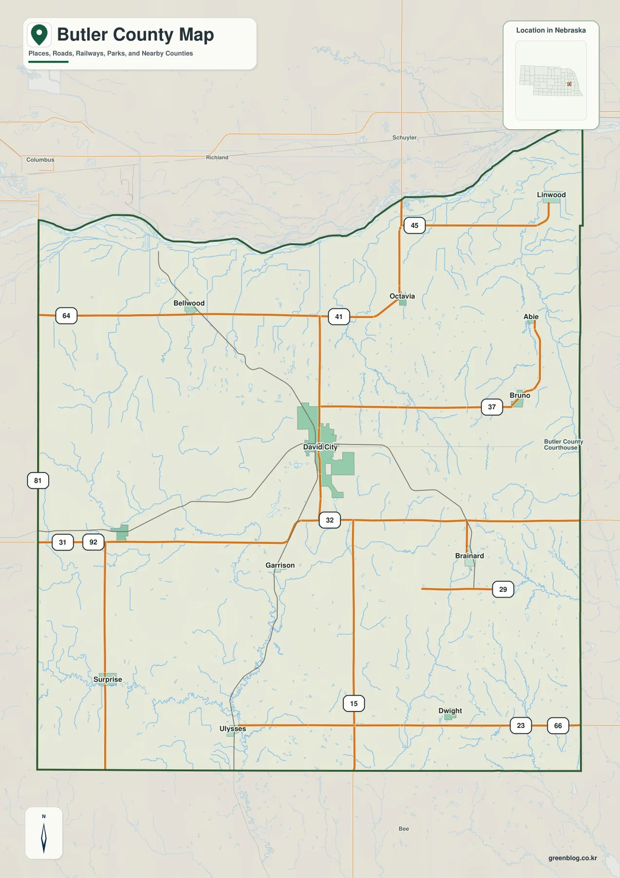
The road map is most complex around David City. The route marked 15 runs north and south through the county seat, while the road marked 32 crosses the same area east to west. Together they provide a simple central framework before following smaller routes into the surrounding rural communities.
Bellwood lies north-northwest of David City near routes marked 64 and 41, while Octavia is farther east along the same broad northern belt. A route marked 45 continues toward Linwood. On the eastern side, Abie and Bruno are linked by north-south local roads, and Brainard lies farther south near the route marked 29.
South of David City, Garrison appears first, with Surprise and Ulysses farther southwest and Dwight in the southeast. Road spacing increases away from the county seat, especially across the rolling rural interior. The map is useful for orientation, but current construction, closures, road surfaces, and actual travel time should be checked with live transportation information.
Six ranked communities reveal a widely dispersed settlement pattern
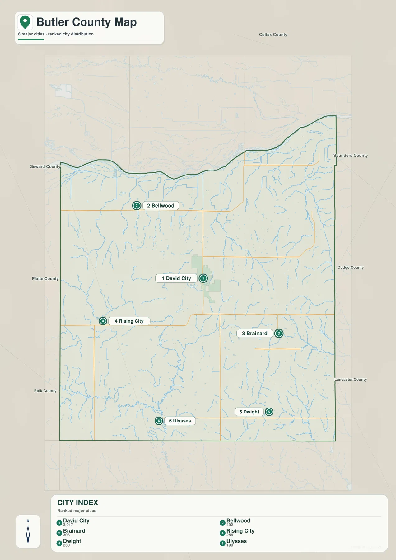
The city distribution map ranks David City first, followed by Bellwood, Brainard, Rising City, Dwight, and Ulysses. Bellwood is northwest of the county seat, Brainard is southeast, Rising City lies to the west, Dwight is close to the southern edge, and Ulysses occupies the southwest. The six markers span much of the county instead of clustering around one corridor.
No straight-line connectors or mileage labels appear between the cities on the supplied map. The useful comparison is therefore positional rather than numerical. The general road map provides the better view when practical travel relationships matter, while the city map strips away minor roads and highlights the county’s main settlement pattern.
The county website lists several smaller places beyond the six ranked communities, including Abie, Bruno, Garrison, Linwood, Octavia, and Surprise. The city map should therefore be read as a ranked summary of larger communities, not as a complete administrative inventory.
The Platte River forms the north while Big Blue tributaries drain the south
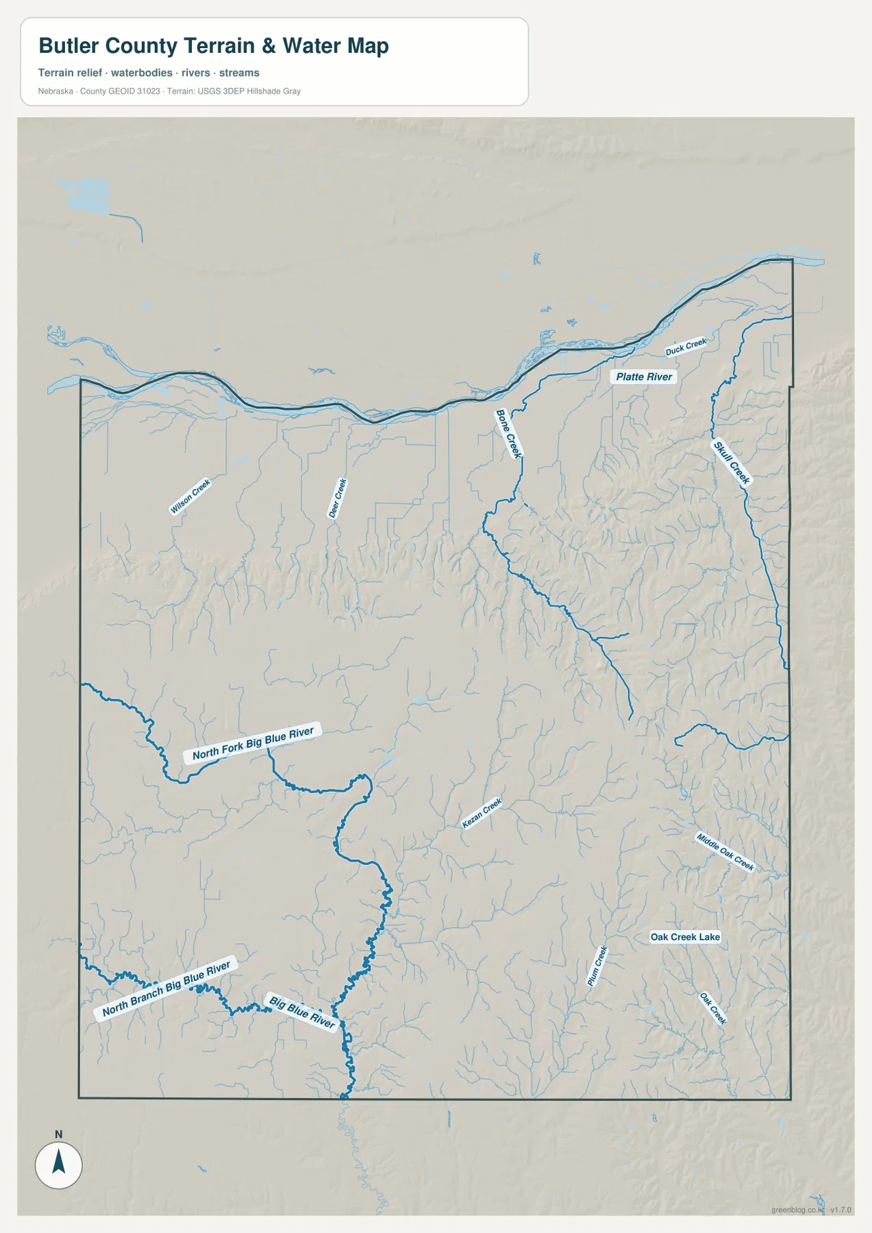
The Platte River is the dominant water feature along the northern edge. It bends across the entire county boundary from west to east, with Duck Creek visible near the northeastern side. Butler County’s official profile also identifies the Platte as the county’s northern boundary. The river corridor is broad and low, a contrast that becomes even clearer on the elevation map.
Wilson Creek and Bone Creek drain the northern interior, while Skull Creek follows a long valley near the eastern side. Bone Creek descends through the north-central area, and Skull Creek cuts a pronounced north-south corridor through heavily dissected terrain. These valleys connect the interior uplands with lower ground closer to the Platte system.
The southern half belongs to the Big Blue drainage. North Fork Big Blue River crosses the southwest, North Branch Big Blue River appears farther south, and Big Blue River is labeled near the lower center of the map. Kansas Creek feeds the same general system, while Middle Oak Creek and Oak Creek occupy the southeast around Oak Creek Lake.
This water map is intended for geographic reference. It does not define flood zones, legal water rights, parcel boundaries, channel depth, or navigability. Those questions require current information from USGS and the appropriate Nebraska or local agency.
Elevation rises away from the Platte plain into the central and southwestern uplands
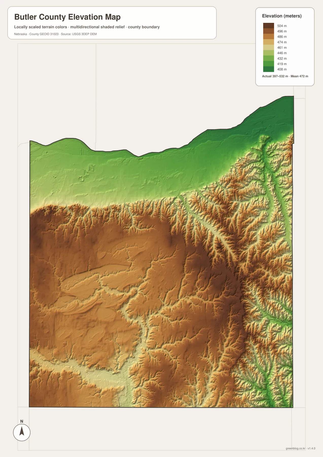
The elevation map reports an actual county-wide range of approximately 397 to 532 meters, with a mean near 472 meters. The lowest greens follow the Platte River across the north and spread through much of the northeastern lowland. The river plain is broad and gently sloping compared with the interior.
Elevation increases through the center and southwest, where brown and darker brown terrain occupies broad uplands cut by many small valleys. South and west of David City, the ground is noticeably higher than the Platte corridor. The relief is not mountainous, but the repeated ridges and drainage cuts create a strongly textured agricultural landscape.
On the eastern side, Skull Creek, Middle Oak Creek, and Oak Creek form long green corridors between higher ridges. The North Fork Big Blue and Big Blue river system does the same in the southwest and south. Comparing the water and elevation maps makes the relationship clear: the main streams consistently occupy the lower parts of the terrain.
The colors are locally scaled for Butler County and are best used to compare one part of this map with another. A similar shade on a different county map may represent another absolute elevation. The generalized surface is not survey-grade information for engineering, construction, drainage design, or property work.
The move from Savannah to David City shifted government away from the river edge
History Nebraska records that the county’s early seat was Savannah near the northern border and that a courthouse had been completed there by 1872. Residents continued to push for a more central location, and an election in 1873 moved the seat to a new site named David City. The county’s official history describes the same multi-election struggle.
The modern map shows why that change mattered geographically. David City sits between Bellwood and Octavia in the north, Rising City to the west, Brainard to the east-southeast, and Ulysses and Dwight to the south. Major roads also meet there, so the county seat now occupies a much more central position than Savannah did along the Platte River edge.
Platte and Big Blue watersheds create two different halves of the county
Butler County becomes much easier to understand when the Platte River and Big Blue system are viewed together. The northern edge is low, broad, and closely tied to the Platte floodplain, while the center and south contain higher uplands cut by North Fork Big Blue River, Big Blue River, and smaller creeks.
That contrast also helps explain the settlement pattern. Bellwood and Octavia sit closer to the flatter northern belt, David City occupies the transition into the higher interior, and Brainard and Dwight lie among more dissected eastern creek valleys. Rising City and Ulysses provide western and southwestern references within the higher agricultural country.
Using the four map views together
For basic orientation, start with David City and the roads marked 15 and 32, then move north toward Bellwood, southeast toward Brainard, west toward Rising City, and south toward Dwight and Ulysses. The city map provides a cleaner view of those same six principal communities when settlement distribution is the main question.
For physical geography, begin with the Platte River, then trace Bone Creek and Skull Creek into the interior before moving south to the North Fork Big Blue, Big Blue River, and Oak Creek system. The elevation map adds the vertical context by showing the Platte plain in green and the higher central and southwestern uplands in tan and brown.
For printing or classroom display, the downloadable high-resolution JPG files preserve more road labels and creek names than the web previews. The county map emphasizes roads and boundaries, the city map summarizes major communities, the water map identifies rivers and tributaries, and the elevation map highlights the change from northern lowlands to the higher interior.
Frequently Asked Questions
Does the city map show distances from David City to the other communities?
No. The supplied city map ranks and locates David City, Bellwood, Brainard, Rising City, Dwight, and Ulysses, but it does not include connector lines or mileage. Use the general road map for relative position and a current routing service when actual driving distance is needed.
Which part of Butler County is lowest?
The Platte River plain along the northern boundary is the lowest broad area. The county-wide elevation range is about 397 to 532 meters, while higher terrain becomes more common through the center and southwest. Skull Creek and the Big Blue tributaries also form lower corridors through the uplands.
Can the river and creek map be used for flood or property decisions?
No. It is a geographic reference showing the Platte River, Big Blue River system, Skull Creek, Bone Creek, Oak Creek, and Oak Creek Lake. Flood risk, water rights, parcel boundaries, channel conditions, and access questions require current authoritative records.
Map File Information
The ZIP contains the original high-resolution JPG files for the Butler County boundary and road map, city distribution map, terrain and water map, and elevation map.
- Included Files: Use only the versions confirmed in the article and supplied images
- File Type: Use the confirmed download contents
- Intended Use: Printing, education, presentations, and map-based projects
Related Maps
Sources and references
- Butler County – About Our County
- History Nebraska – Butler County Historical Note
- History Nebraska – Shinn’s Ferry
- U.S. Census Bureau TIGER/Line Shapefiles
- USGS National Hydrography
- USGS 3D Elevation Program
These maps are intended for geographic reference. For legal boundaries, land ownership, flood determinations, water rights, road conditions, construction, surveying, or other decisions requiring current authoritative information, consult Butler County and the responsible state or federal agency.
Green Map creates custom-edited map images using open geographic data sources such as geoBoundaries, Natural Earth, OpenStreetMap, and government open data. These maps are edited visual materials, not raw data files, and are provided for education, documents, presentations, and graphic reference.