Gallatin County stretches from the Bozeman valley south through Big Sky to the West Yellowstone area, creating one of the clearest valley-to-mountain transitions in southwestern Montana. Bozeman, Belgrade, Manhattan, and Three Forks occupy the lower northern part of the county, while settlement thins rapidly farther south. Gallatin River and East Gallatin River organize the northern valley, and Madison River becomes a stronger reference in the southern section. The maps shown on this page are also available together as high-resolution JPG files in the download ZIP below.
The official Gallatin County site describes the county as a broad Rocky Mountain valley surrounded by mountain lands and identifies Bozeman as the county seat. That description matches the maps well. The northern valley has the densest road network and most of the ranked cities, while the long southern extension is dominated by high ridges, river valleys, and the route through Big Sky toward West Yellowstone.
Table of Contents
Bozeman and Belgrade anchor the northern road network
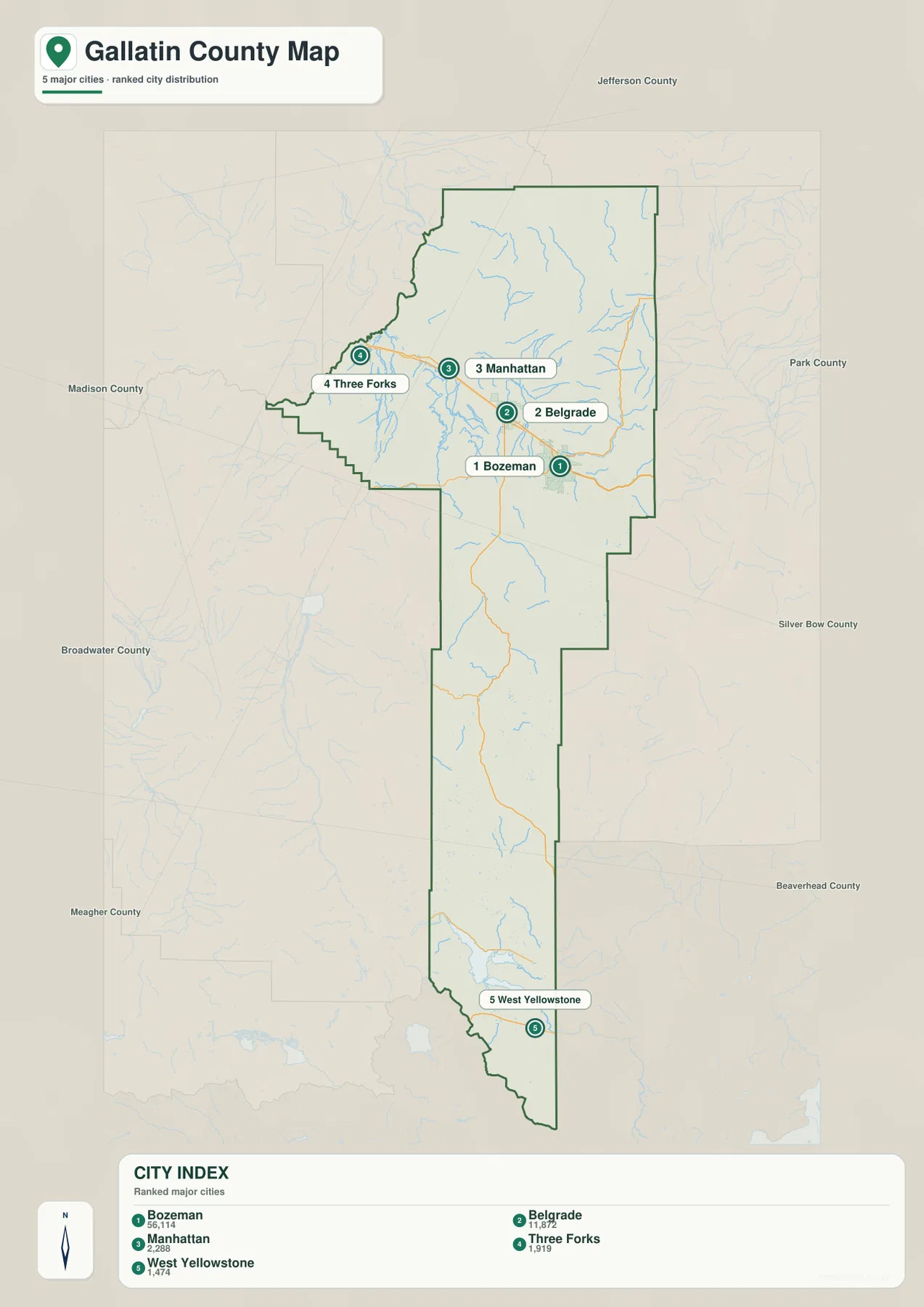
On the general county map, Bozeman sits near the center of the northern valley, with Belgrade just to the west. Route 85 passes through the same general corridor, I-90 runs east from the Bozeman side, and Route 191 heads south into the county’s long mountain section. North and northeast of Bozeman, routes 86 and 191 provide additional references.
Manhattan lies west of Belgrade near Route 10 and the Gallatin River Ranch area. Farther west, the map extends toward the Three Forks side. Gallatin Gateway appears south of Bozeman where the road network begins to narrow into the mountain corridor leading toward Big Sky.
Small labels such as Bridger, Sedan, and Ponderosa Pines help distinguish the outer portions of the northern county. The map is useful for overall orientation, but it does not provide live road conditions. Mountain weather, winter restrictions, and access near park areas should be checked through current transportation and agency sources.
The ranked city map shows a dense north and a distant southern outlier
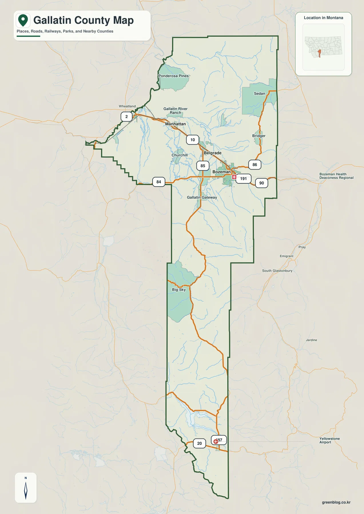
The city map ranks five places: Bozeman, Belgrade, Manhattan, Three Forks, and West Yellowstone. The printed index lists Bozeman at 56,114, Belgrade at 11,872, Manhattan at 2,288, Three Forks at 1,919, and West Yellowstone at 1,474. These are the values embedded in the supplied map and should not be treated as guaranteed current population estimates. Current figures should be checked through recent U.S. Census Bureau data.
The pattern is visually simple. Bozeman and Belgrade sit close together in the northern valley, Manhattan and Three Forks extend the cluster westward, and West Yellowstone appears far south near the county’s lower end. That separation shows how much of Gallatin County lies beyond the main urban valley.
No connector lines or mileage labels are printed between the ranked places. The spacing therefore should be read only as a location reference, not as straight-line or driving distance. Actual travel routes should be checked on the general county map and with current navigation information.
Gallatin River and East Gallatin River divide the northern valley
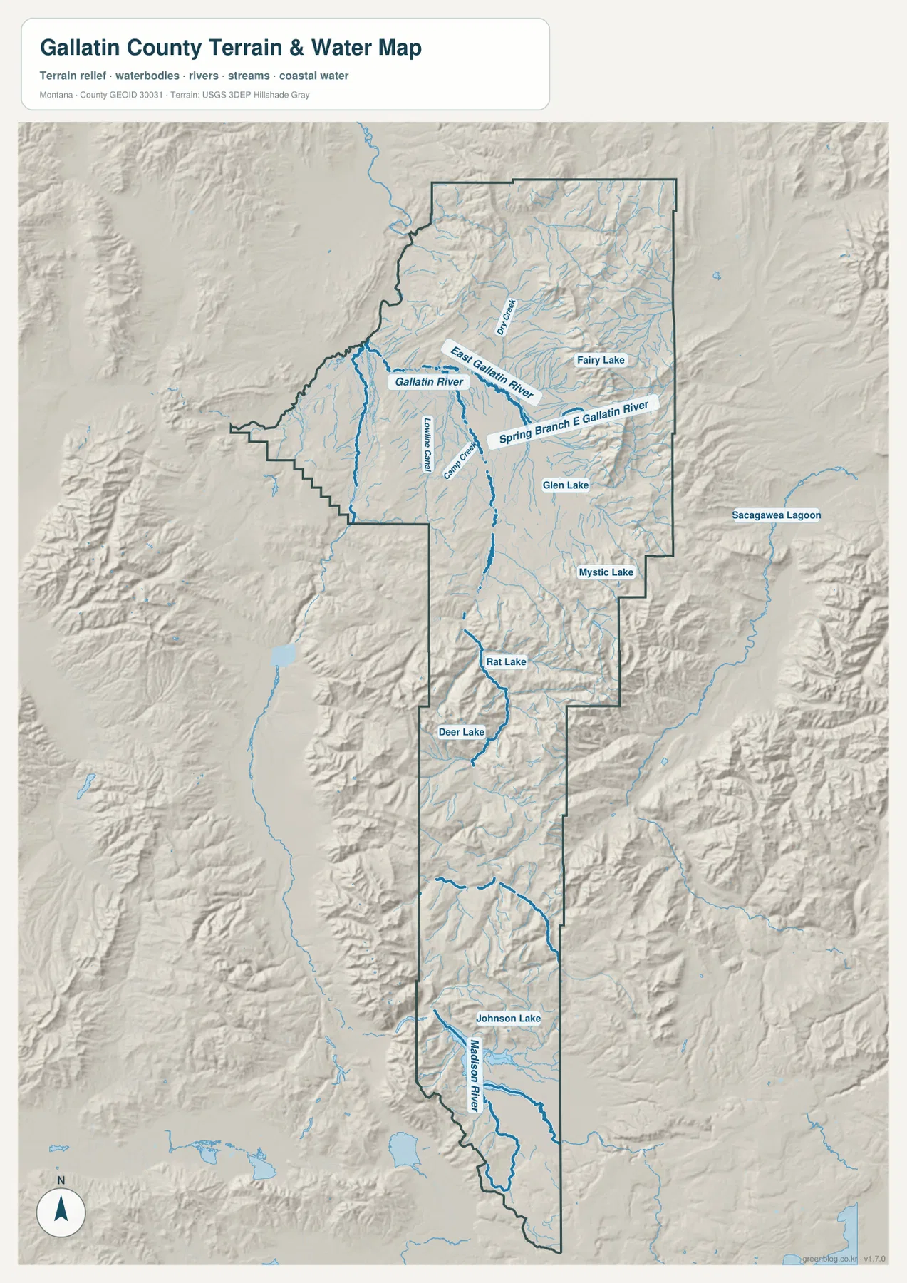
The terrain-and-water map makes Gallatin River one of the strongest features in the northern county. East Gallatin River forms a separate branch farther east, while Dry Creek, Spring Branch East Gallatin River, Camp Creek, and Lowline Canal add smaller local references. These waterways cut through the same broad lowland that contains Bozeman, Belgrade, and much of the county’s road network.
Fairy Lake and Glen Lake appear near the northeastern mountain edge, while Mystic Lake lies farther south and east of the main valley. These water bodies are small compared with the river system, but they are useful markers because they sit close to abrupt terrain changes.
The water map becomes even more informative when compared with the elevation view. Gallatin River and its associated valleys stay in lower green terrain while mountain ridges rise rapidly around them. This is a geographic reference map, not a flood-hazard, navigation, parcel, water-rights, or safe-crossing product.
Big Sky and the Madison River mark the shift into southern mountain country
South of Gallatin Gateway, the road corridor narrows as it approaches Big Sky. Rat Lake and Deer Lake appear in this middle-southern mountain section, surrounded by much more tightly folded terrain than the broad Bozeman valley. Route 191 continues through this corridor toward the southern end of the county.
Madison River becomes one of the main water references farther south. Johnson Lake is labeled nearby, and the terrain around the river is increasingly rugged as the map approaches West Yellowstone. Settlement is sparse here, so rivers, lakes, and valleys become more useful for orientation than town names.
West Yellowstone lies near Yellowstone National Park, but the county map does not show current park-road openings or access restrictions. Seasonal closures, park entry information, and mountain travel conditions should be checked separately through the appropriate agencies.
Elevation rises from about 1,206 to 3,213 meters
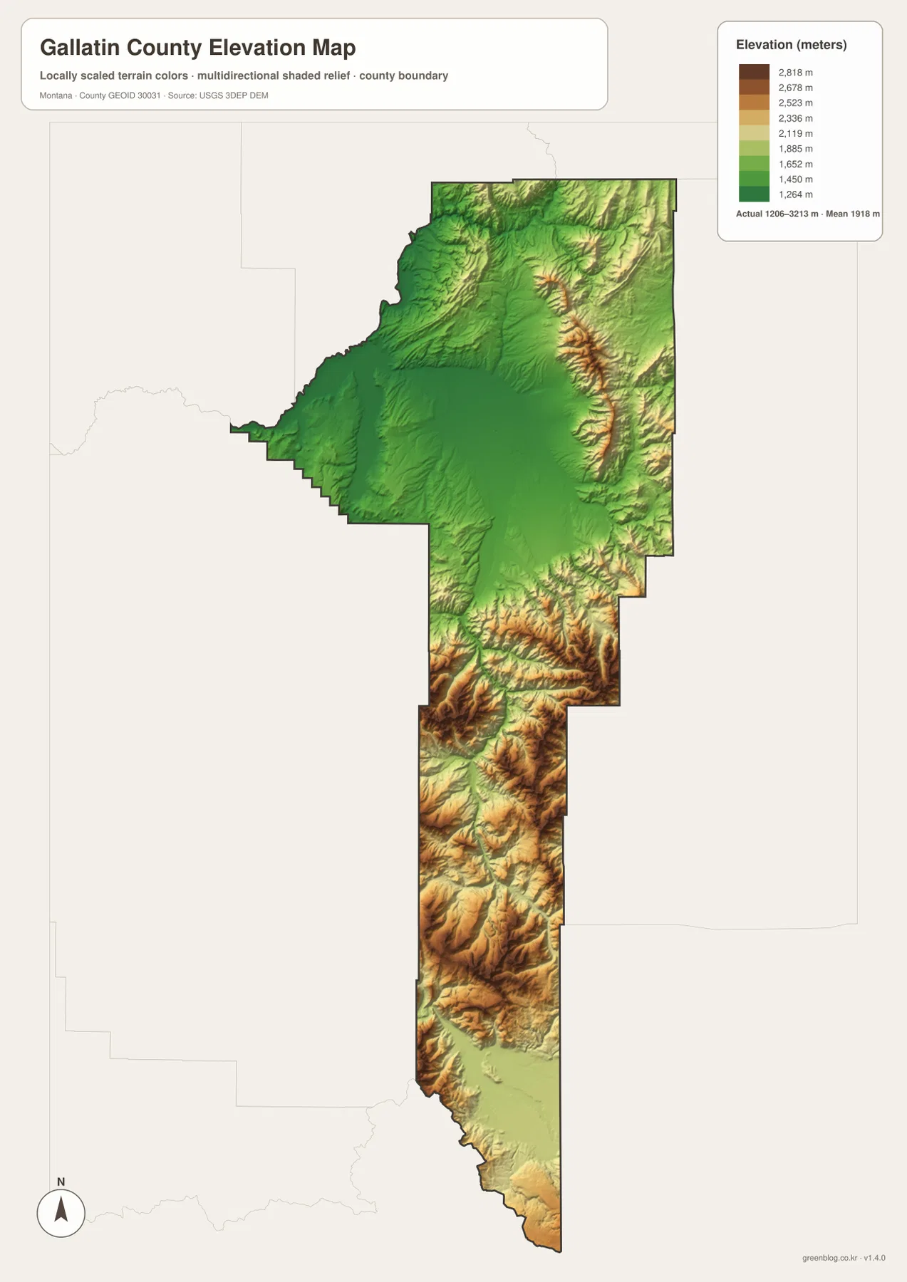
The elevation map reports an actual county range of about 1,206 to 3,213 meters, with a mean elevation near 1,918 meters. The Bozeman-Belgrade-Manhattan valley appears as a large green lowland in the northern center. High yellow and brown ridges line the eastern edge and become even more dominant through the long southern section.
The northeastern mountains rise sharply above the valley over short distances. Around Big Sky, the relief becomes much more complex, with high ridges separated by narrow lower valleys. Farther south toward West Yellowstone, the county remains mountainous even where river corridors create lighter and greener low routes.
Gallatin River and Madison River occupy some of the most visible low corridors on the elevation surface. Comparing the water and elevation maps makes it clear that both rivers and major roads tend to follow the more accessible valley floors. The elevation map is intended for county-wide comparison and should not be used as survey-grade or engineering-grade data for a specific property.
Two regional views explain most of the county
A useful way to read Gallatin County is to separate the northern urban valley from the long southern mountain corridor. Bozeman, Belgrade, Manhattan, Three Forks, and Gallatin River provide the strongest references in the north. South of Gallatin Gateway, Big Sky, Madison River, and West Yellowstone take over as the key landmarks.
The smaller lakes add detail within that larger structure. Fairy Lake and Glen Lake sit near the northeastern high country, Mystic Lake lies farther south of the main valley, and Rat Lake, Deer Lake, and Johnson Lake help break up the long mountain section. These features are more useful when treated as regional markers rather than as a list of isolated water bodies.
The WebP images embedded in the article are convenient for quick browsing. The high-resolution JPG files in the ZIP are better for printing or enlarging small road, river, and lake labels. Because these maps are static references, current road closures, park access, stream conditions, and seasonal restrictions should be checked through official sources before travel or field use.
Frequently Asked Questions
Does the city map show distances between Bozeman, Belgrade, Manhattan, and West Yellowstone?
No. The ranked-city map shows the locations and printed index values for Bozeman, Belgrade, Manhattan, Three Forks, and West Yellowstone, but it does not include connector lines or mileage labels. Actual distances should be checked with current road and navigation information.
Where is the highest terrain in Gallatin County?
The highest terrain is concentrated along the eastern mountain edge and through much of the long southern section. The Bozeman-Belgrade-Manhattan valley is much lower, while the Big Sky and West Yellowstone directions contain far more high relief.
Can the 1,206–3,213 meter elevation range be used for a property or engineering project?
No. The range is a county-wide reference for comparing the lower northern valley with surrounding mountain terrain. Precise site elevations should come from an authoritative source such as the USGS 3D Elevation Program and, when necessary, a professional survey.
Map File Information
Download the Gallatin County county, city, terrain-and-water, and elevation maps as high-resolution A3 JPG files.
- Included Files: county map, city map, terrain and water map, elevation map
- File Type: ZIP containing 4 JPG files
Related Maps
Sources and References
County background and information about Bozeman as the county seat are available from the official Gallatin County About page. Boundary and road-reference data can be checked through U.S. Census Bureau TIGER/Line Shapefiles.
Hydrographic reference data are available from USGS National Hydrography, and elevation data can be checked through the USGS 3D Elevation Program.
Green Map creates custom-edited map images using open geographic data sources such as geoBoundaries, Natural Earth, OpenStreetMap, and government open data. These maps are edited visual materials, not raw data files, and are provided for education, documents, presentations, and graphic reference.