Worth County sits along Missouri’s northern border, where Grant City, Sheridan, Allendale, Worth, Denver, and Irena are scattered across a compact landscape of rolling ridges and stream valleys. Route 46 crosses the Grant City–Allendale corridor from west to east, while U.S. 169 provides the main north-south reference through Grant City. The Grand River, Middle Fork Grand River, and East Fork Grand River form three long drainage corridors that divide the county’s uplands. High-resolution map files are available for download in the section below.
This page separates those features into a general county map, a ranked city map, a terrain-and-water map, and an elevation map showing roughly 265 to 369 meters of relief. High-resolution JPG originals of all four can be downloaded together in one ZIP for enlargement, A3 printing, classroom materials, reports, or personal reference.
Table of Contents
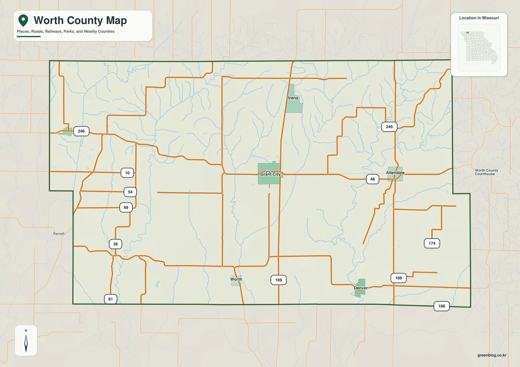
Grant City anchors Route 46 and U.S. 169 across the county
Grant City is the easiest place to begin reading the general map. It lies slightly north of the county center near the crossing of Route 46 and U.S. 169, giving the community strong east-west and north-south references. The Missouri Secretary of State’s 2025–2026 Missouri Roster identifies Grant City as the Worth County seat, so it is also the main administrative reference.
Route 46 runs east from Grant City toward Allendale and west through the rural interior. U.S. 169 extends south toward the community of Worth and continues north past the Grant City area toward the state line. These two roads provide the simplest framework for organizing the rest of the county map.
Missouri Route 245 appears in the northeast, while Routes 189 and 188 provide references in the southeast. Route 246 is visible toward the western side, and several other numbered roads appear around the county edge. The internal road network remains sparse compared with more urban Missouri counties, so the main numbered routes and town labels carry more navigational value.
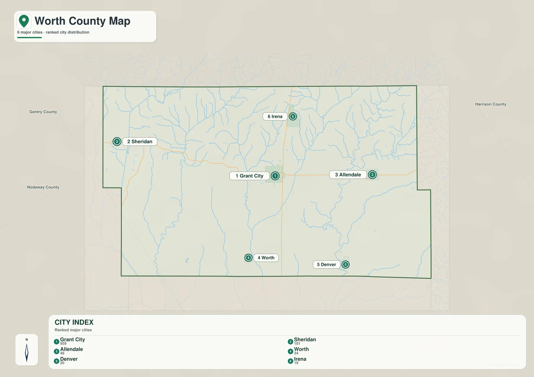
Sheridan sits near the northwestern side, Allendale in the east, Worth and Denver in the south, and Irena north of Grant City. The six places are small and widely separated, making them useful directional markers rather than parts of one continuous built-up area.
Grant City leads six very small communities spread across the county
The city map highlights Grant City, Sheridan, Allendale, Worth, Denver, and Irena. The map index labels Grant City with 959, Sheridan with 181, Allendale with 46, Worth with 34, Denver with 20, and Irena with 19. Grant City is clearly the largest highlighted place, while the other communities remain very small.
Grant City occupies the north-central interior, Sheridan the northwest, and Allendale the east. Worth and Denver lie in the south, while Irena provides a northern reference. Their distribution is valuable because each place helps define a different part of a county with long stretches of farmland between settlements.
Grant City combines the highest city-index value with the county-seat role. Sheridan helps locate the western uplands, Allendale the Route 46 corridor to the east, and Irena the northern ridges and headwater streams. Worth and Denver provide useful references where the southern Grand River tributaries cross local roads.
The city-index values are best treated as map-ranking values rather than a substitute for current population statistics. Their main purpose here is to show which communities the map emphasizes and how those settlements are distributed across Worth County.
Three Grand River corridors divide the rolling uplands
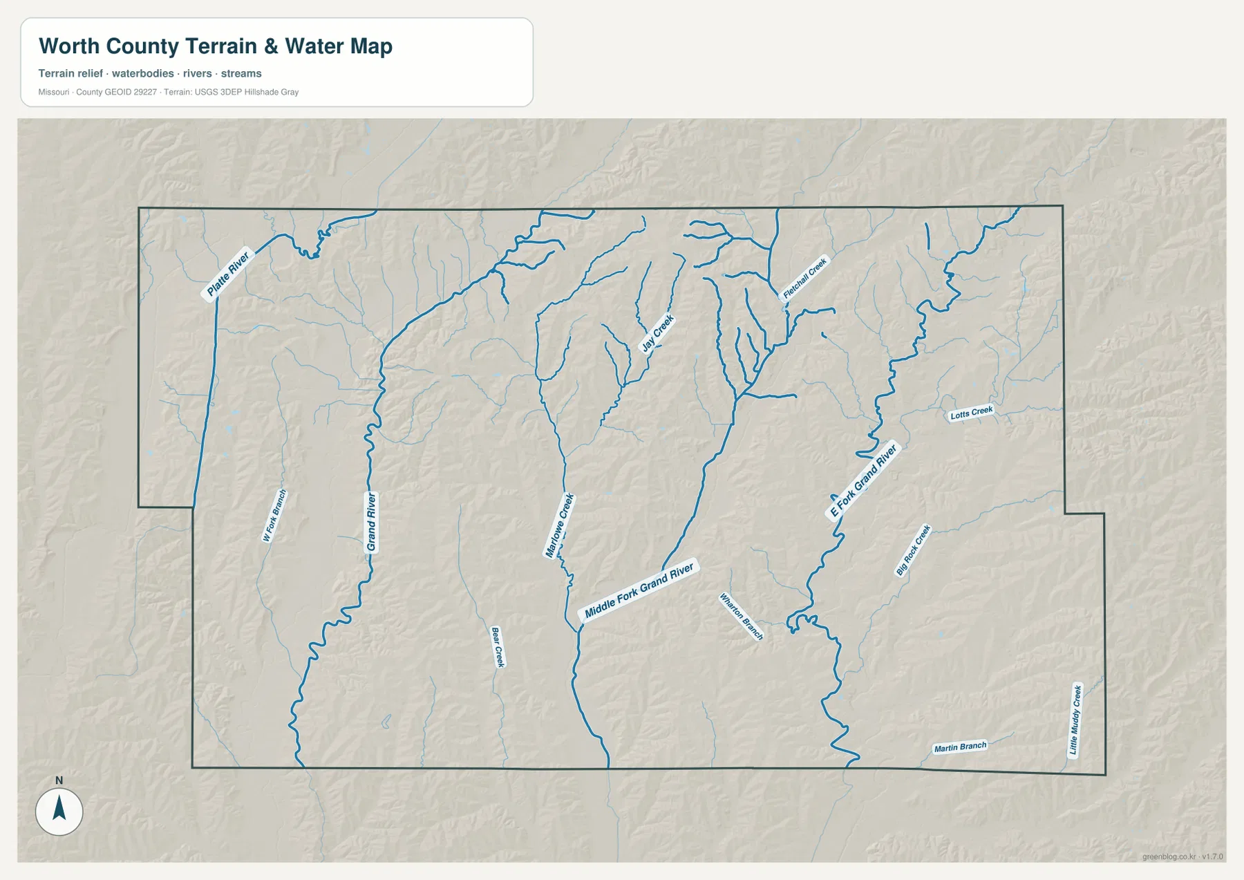
The strongest pattern on the terrain-and-water map is created by the Grand River system. Grand River runs through the western interior, Middle Fork Grand River follows a long central corridor, and East Fork Grand River occupies the eastern side. Their parallel valleys break the county into several belts of higher ground.
Platte River appears near the northwestern boundary, while Jay Creek crosses the north-central interior with several short tributaries. Millstone Creek provides a central-western reference, Fletcher Creek lies farther northeast, and Lotts Creek crosses the eastern side.
Big Rock Creek appears in the southeast, with Martin Branch and Little Muddy Creek along the southern side. Wilson Branch adds another smaller drainage east of the center. Together these streams show how densely the uplands are dissected even though Worth County has no large reservoir dominating the landscape.
The terrain-and-water map is intended for geographic reference, not flood determination, depth analysis, navigation, parcel boundaries, or legal water boundaries. Water levels in the Grand River system and smaller creeks can change with rainfall, so current flood or access decisions should rely on up-to-date official information.
Elevation ranges from about 265 to 369 meters
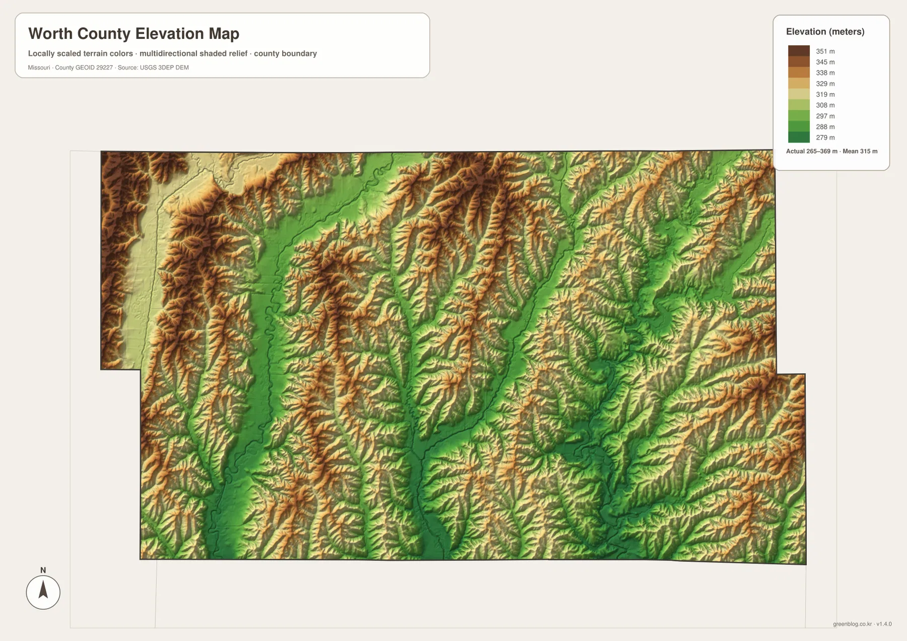
The elevation map reports an actual range of roughly 265 to 369 meters and a mean near 315 meters. Higher brown terrain is prominent along the western side and across several north-central ridges, with additional uplands in the east and southeast. The county is not mountainous, but the short ridges and closely spaced stream valleys create noticeable local relief.
Grand River follows a long green lower corridor through the west. Middle Fork Grand River forms another central low route, and East Fork Grand River creates a broad valley in the east. These three drainage lines consistently occupy lower terrain than the ridges separating them.
The Grant City area lies among rolling uplands rather than on one broad flat floodplain. Higher ridges appear toward Irena and Sheridan, while the Allendale side also contains repeated upland strips between tributary valleys. The elevation map therefore adds useful context that is difficult to see from the road layer alone.
This county-scale elevation surface is useful for broad relief comparison, not for engineering, construction, drainage design, parcel-level elevation decisions, or survey-grade measurement. Site-specific work requires more detailed official elevation data or field surveying.
Use Grant City for roads, then compare the three Grand River valleys
Start with Grant City, Route 46, and U.S. 169 when roads and settlement locations matter most. Sheridan lies to the northwest, Allendale to the east, Worth and Denver to the south, and Irena to the north. Route 245 and the southeastern Routes 189 and 188 then provide additional edge references.
For terrain, compare Grand River in the west, Middle Fork Grand River through the center, and East Fork Grand River in the east. Switching to the elevation map shows each waterway occupying a lower green corridor with higher rolling ridges between them. Jay Creek, Millstone Creek, and Fletcher Creek add finer detail to the northern and central uplands.
Worth County is defined less by a large town or major reservoir than by small rural communities and a dense network of river tributaries. Grant City’s highway crossing provides a simple first reference, while the water and elevation maps reveal a landscape divided into repeated ridges and long stream valleys.
The downloadable JPG originals contain more pixels than the WebP previews embedded on the page, making them better for enlargement, A3 printing, classroom handouts, reports, and personal reference. They remain general-purpose maps, so legal boundaries, live road restrictions, current water conditions, and precise site elevations should always be checked against current official sources.
Frequently Asked Questions
Where is the Worth County seat?
Grant City is the Worth County seat. The Missouri Secretary of State’s 2025–2026 Missouri Roster identifies Grant City as the county seat, and the town is easy to locate near the Route 46 and U.S. 169 crossing.
How much elevation change is shown across Worth County?
The elevation map shows an actual range of about 265 to 369 meters with a mean near 315 meters. Western and north-central ridges are higher, while the Grand River, Middle Fork Grand River, and East Fork Grand River valleys are lower.
Which waterways are the best starting points on the terrain map?
Start with Grand River in the west, Middle Fork Grand River through the center, and East Fork Grand River in the east. Platte River, Millstone Creek, and Jay Creek provide additional references in the north and west.
Map File Information
The download ZIP contains high-resolution JPG versions of the Worth County general map, city map, terrain-and-water map, and elevation map.
- File Type: JPG
Related Maps
Sources and References
Boundary and road reference data are supported by U.S. Census Bureau TIGER/Line, water features by USGS National Hydrography, and elevation data by the USGS 3D Elevation Program. Grant City’s county-seat status is listed in the Missouri Secretary of State 2025–2026 Missouri Roster.
Green Map creates custom-edited map images using open geographic data sources such as geoBoundaries, Natural Earth, OpenStreetMap, and government open data. These maps are edited visual materials, not raw data files, and are provided for education, documents, presentations, and graphic reference.