Webster County occupies a high part of the southwestern Missouri Ozarks, with Marshfield, Niangua, Seymour, Fordland, and Diggins spread across broad uplands cut by deep stream valleys. I-44 provides the strongest route through Marshfield, while U.S. 60 crosses the southern county through the Fordland–Diggins–Seymour corridor. The road map gives a relatively simple first impression, but the elevation and water views reveal a much more dissected landscape. High-resolution map files are available for download in the section below.
This page brings together a general county map, a city-connections map centered on Marshfield, a terrain-and-water map, and an elevation map covering roughly 333 to 530 meters. High-resolution JPG originals can be downloaded together in one ZIP for enlargement, A3 printing, classroom materials, reports, or personal reference.
Table of Contents
Marshfield sits on the high interior between I-44 and the U.S. 60 towns
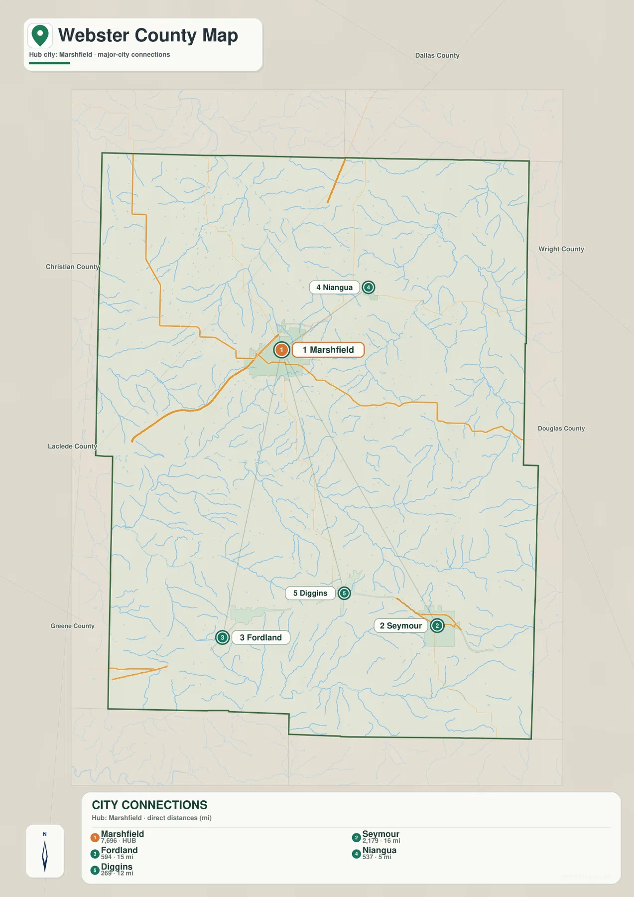
Marshfield is the best starting point on the general map. It lies slightly north of the county center, and I-44 crosses the city on a southwest-to-northeast course. The official Webster County website identifies Marshfield as the judicial seat and places the county courthouse there, giving the city both administrative and transportation importance.
South of Marshfield, Diggins and Fordland provide useful references toward U.S. 60, while Seymour lies farther southeast. Rogersville appears near the southwestern boundary. Together these places form a separate southern corridor from the I-44 route through Marshfield.
Niangua lies northeast of Marshfield in a more rural part of the county. Route 38 is visible toward the northwest, and the smaller roads across the northern half bend around stream valleys and rolling uplands rather than following a dense urban grid. Using I-44 and U.S. 60 as the first two references makes the rest of the road network much easier to follow.
The map also shows Webster County in relation to Dallas County to the north, Wright County to the east, Douglas County to the southeast, Christian and Greene counties toward the southwest, and Laclede County to the west. The southern and southwestern boundary includes a few stepped sections, so neighboring county labels are useful for tracing the outline.
Niangua is closest to Marshfield, while Seymour and Fordland lie farther south
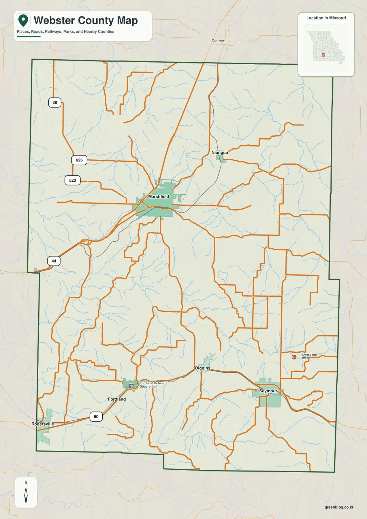
The city-connections map uses Marshfield as its hub and highlights Seymour, Fordland, Niangua, and Diggins. The map index labels Marshfield with 7,696, Seymour with 2,179, Fordland with 594, Niangua with 537, and Diggins with 269. Marshfield is therefore the largest highlighted community by a wide margin.
The connector labels show straight-line rather than driving distances. Niangua is about 5 miles from Marshfield, Diggins about 12 miles, Fordland about 15 miles, and Seymour about 16 miles. Road mileage can be longer because routes curve around uplands and stream valleys.
The four connected places also occupy different directions. Niangua lies northeast of Marshfield, Diggins and Fordland are to the south and southwest, and Seymour is farther southeast. Learning those positions first makes it much easier to understand how the I-44 and U.S. 60 corridors divide the county’s main settlement pattern.
Webster County does not form one continuous urban area. Marshfield stands apart as the main county center, while the U.S. 60 communities form a second band of settlement farther south. The city map is useful precisely because it simplifies that pattern before the detailed road and drainage layers are added back in.
Niangua headwaters drain the north while the James River cuts across the south
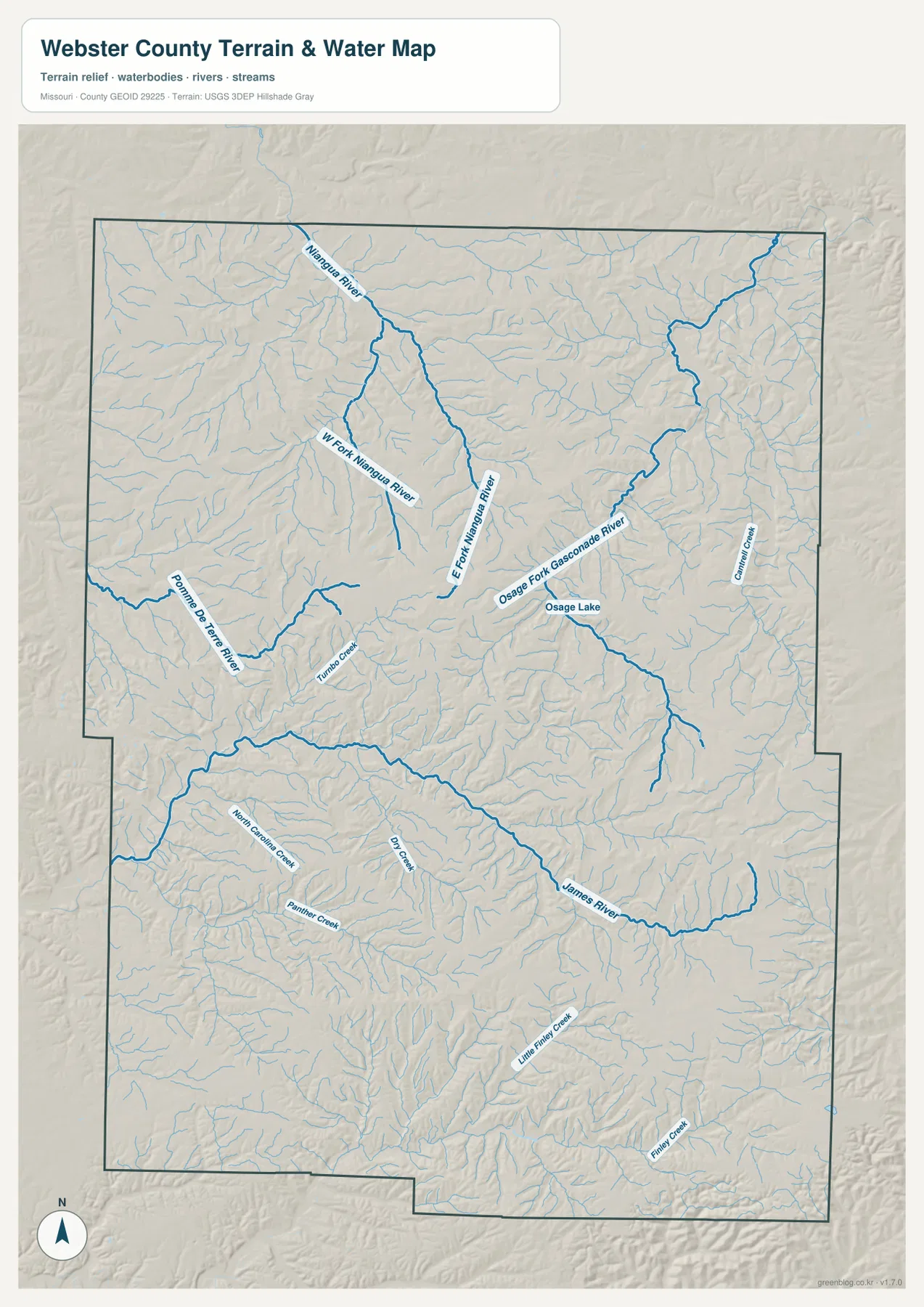
The northern water network is organized around the Niangua River and its forks. West Fork Niangua River and East Fork Niangua River occupy long valleys through the north-central uplands, with many smaller tributaries branching into the surrounding ridges. This part of the county is defined more by winding streams than by large lakes.
Farther northeast, Osage Fork Gasconade River forms another pronounced valley near Osage Lake. Pomme de Terre River appears in the western interior, and Turnbo Creek provides a smaller reference nearby. These waterways leave the county in different directions, showing that Webster County sits across several headwater drainage areas rather than one simple basin.
The James River is the dominant southern water feature. It enters from the west, crosses the lower half of the county, and bends toward the southeast. North Carolina Creek, Panther Creek, and Dry Creek feed the broader southern drainage, while Little Finley Creek and Finley Creek cut into the southeastern uplands around the Seymour side.
The terrain-and-water map is intended for geographic reference, not flood determination, depth analysis, navigation, parcel boundaries, or legal water boundaries. River and creek conditions can change with rainfall, so current flood or access decisions should rely on up-to-date official information.
Elevation rises from about 333 to 530 meters across the Ozark upland
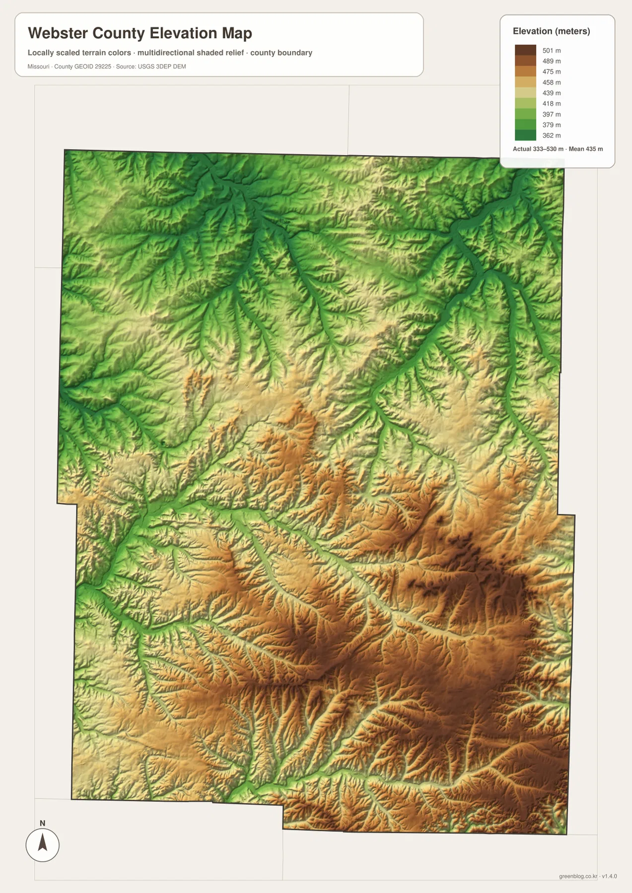
The elevation map reports an actual range of roughly 333 to 530 meters and a mean near 435 meters. Higher brown terrain spreads across much of the south and southeast, where several ridges rise above 500 meters. The northern half remains elevated overall, but the Niangua River system creates deep green valleys that make the local relief much more obvious.
Marshfield itself occupies distinctly high ground. Webster County’s official history describes the county as part of the highest extensive upland area of Missouri’s Ozarks and gives Marshfield an elevation of about 1,490 feet. That description fits the map well: the county seat sits on a broad interior upland rather than in one of the major river valleys.
The James River forms a lower corridor across the southern county, and tributaries cut narrow green valleys into the surrounding uplands around Diggins and Seymour. Osage Fork Gasconade River and Pomme de Terre River create similar low routes in the north and west. In many places the terrain climbs quickly once the map moves away from a stream floor.
This county-scale elevation surface is useful for comparing broad relief, but it is not survey-grade or engineering-grade measurement. Construction, drainage design, parcel elevation, and other site-specific work require more detailed official elevation data or field surveying.
Two road corridors and two major river systems explain much of the county
For settlement and travel, begin with Marshfield and I-44, then move south to the U.S. 60 communities of Fordland, Diggins, and Seymour. Niangua provides the clearest northeastern town reference, while Rogersville helps locate the southwestern edge near Greene County.
For terrain, compare the Niangua River network in the north with the James River in the south. The Niangua forks carve multiple valleys through the north-central upland, while the James follows a longer southern corridor. Pomme de Terre River and Osage Fork Gasconade River add two more drainage directions, showing why the county’s surface is so heavily dissected.
Webster County’s strongest geographic feature is the combination of a generally high Ozark surface with deep stream valleys. The road map emphasizes Marshfield and the U.S. 60 towns, but the water and elevation maps explain why local roads bend repeatedly and why even nearby communities can be separated by pronounced ridges and hollows.
The downloadable JPG originals contain more pixels than the WebP previews embedded on the page, making them better for enlargement, A3 printing, classroom handouts, reports, and personal reference. They remain general-purpose maps, so legal boundaries, live road restrictions, current water conditions, and precise site elevations should always be checked against current official sources.
Frequently Asked Questions
How far are Niangua and Seymour from Marshfield?
The city-connections map shows straight-line distances of about 5 miles from Marshfield to Niangua and 16 miles to Seymour. Diggins is about 12 miles away and Fordland about 15 miles; driving distances can be longer.
Where is the strongest elevation contrast in Webster County?
The map shows the clearest contrast between the high southern and southeastern Ozark uplands and the lower valleys cut by the Niangua and James river systems. The mapped range is about 333 to 530 meters, with a mean near 435 meters.
Why does Marshfield appear on such high ground?
Webster County’s official history describes the county as part of the highest extensive upland area of Missouri’s Ozarks and lists Marshfield at about 1,490 feet above sea level. The elevation map likewise places the county seat on broad high terrain away from the deepest river valleys.
Map File Information
The download ZIP contains high-resolution JPG versions of the Webster County general map, city-connections map, terrain-and-water map, and elevation map.
- File Type: JPG
Related Maps
Sources and References
Boundary and road reference data are supported by U.S. Census Bureau TIGER/Line, water features by USGS National Hydrography, and elevation data by the USGS 3D Elevation Program. County-seat and upland information is available from the official Webster County About page.
Green Map creates custom-edited map images using open geographic data sources such as geoBoundaries, Natural Earth, OpenStreetMap, and government open data. These maps are edited visual materials, not raw data files, and are provided for education, documents, presentations, and graphic reference.