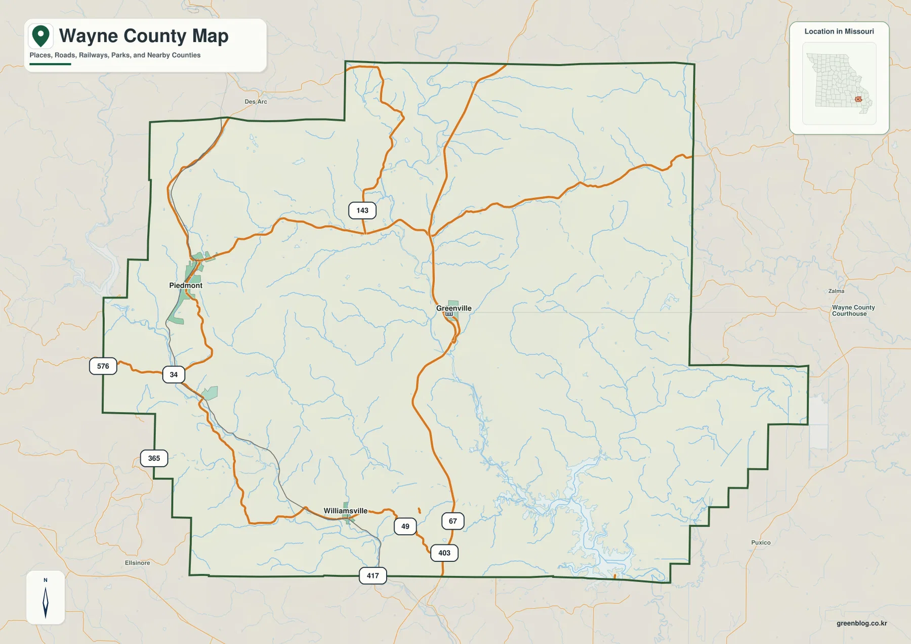
Wayne County lies in the southeastern Missouri Ozarks, where Piedmont, Greenville, Williamsville, and Mill Spring occupy a landscape dominated by steep ridges, river valleys, and the upper reaches of Wappapello Lake. U.S. 67 is the strongest north-south road reference through Piedmont and Greenville, while Route 34 crosses the western side and Route 143 reaches into the northern uplands. The St. Francis River forms the main central drainage corridor, with the Black River and other streams cutting additional valleys through the hills. High-resolution map files are available for download in the section below.
This page separates those features into a general county map, a city-connections map, a terrain-and-water map, and an elevation map showing roughly 98 to 437 meters of relief. High-resolution JPG originals of all four can be downloaded together in one ZIP for enlargement, A3 printing, classroom materials, reports, or personal reference.
Table of Contents
Piedmont, Greenville, and U.S. 67 provide the clearest road framework
Piedmont is the easiest place to begin reading the general map. It lies in the western-central county where U.S. 67 passes through the city and Route 34 crosses from west to east. Route 143 reaches the northern interior, providing another useful reference through the higher Ozark terrain.
Greenville lies east of Piedmont near the center of the county and is also served by U.S. 67. Missouri Secretary of State county information identifies Greenville as the Wayne County seat and lists the Wayne County Courthouse at 109 Walnut Street. Piedmont therefore works well as the map’s urban and road hub, while Greenville provides the main administrative reference.
Williamsville lies in the southwest, with Routes 49 and 67 helping organize the southern road network. Routes 403 and 417 appear near the southern boundary, while Routes 365 and 576 provide western references. The settlement pattern is sparse away from the main towns, so numbered roads remain more useful than local streets across the rural interior.
The eastern and southeastern county is easier to understand through the St. Francis River and Wappapello Lake corridor than through towns. Wayne County also has a stepped, irregular boundary, with Madison and Iron counties to the north, Bollinger and Stoddard counties to the east, and Reynolds and Carter counties to the west. Those neighboring labels help clarify the county outline.
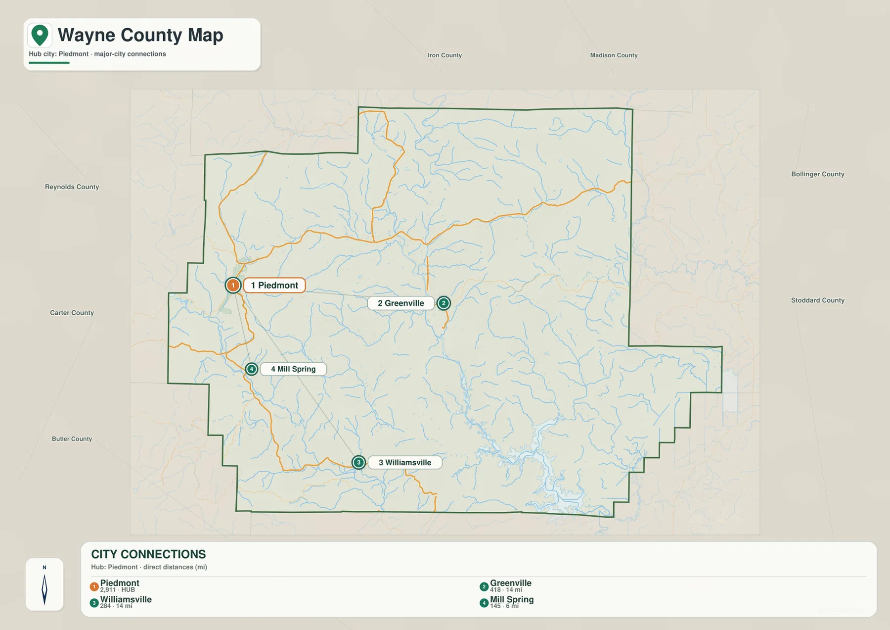
Greenville and Williamsville are about 14 miles from Piedmont
The city-connections map uses Piedmont as its hub and highlights Greenville, Williamsville, and Mill Spring. The map index labels Piedmont with 2,911, Greenville with 418, Williamsville with 284, and Mill Spring with 145, making Piedmont the largest highlighted place.
The distance labels are straight-line measurements rather than driving mileage. Greenville is shown about 14 miles from Piedmont, Williamsville about 14 miles away, and Mill Spring about 6 miles away. Actual road trips can be longer because routes bend through the Ozark hills and around streams.
The connected places also provide different directional references. Greenville lies east of Piedmont, Williamsville farther southeast, and Mill Spring to the south. Once these positions are familiar, the U.S. 67 and Route 34 corridors on the general map become much easier to follow.
Wayne County has no large urban corridor, and its communities are separated by extensive forested and hilly terrain. The city map is therefore most useful for orientation rather than for implying that the settlements form a continuous built-up area.
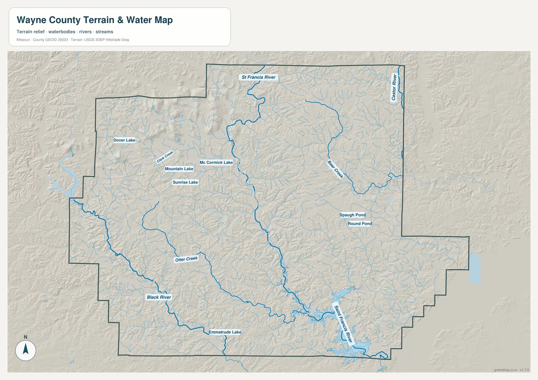
St. Francis River descends toward Wappapello Lake through the county center
The St. Francis River is the strongest water feature on the terrain map. It enters the northern county, winds through the center, and continues southeast into the upper reaches of Wappapello Lake. The U.S. Army Corps of Engineers manages Wappapello Lake as a flood-risk-management reservoir in the St. Francis River Basin, and the Greenville Recreation Area provides access near the upper end of the lake.
The Black River crosses the southwestern county in a separate low corridor, with Otter Creek joining the surrounding drainage. Emmatrude Lake provides another small reference in the southwest. This river valley contrasts strongly with the higher ridges west and northwest of Piedmont.
Bear Creek crosses the northeastern interior, while the Castor River appears along the eastern edge. Clark Creek, Dover Lake, Mountain Lake, Sunrise Lake, and McCormick Lake provide useful western and northwestern landmarks. Spaugh Pond and Round Pond appear farther east of the center.
The terrain-and-water map is intended for geographic reference, not flood determination, depth analysis, navigation, parcel boundaries, or legal water boundaries. Water levels and operating conditions on Wappapello Lake and the St. Francis River can change, so current recreation or safety decisions should rely on up-to-date official information.
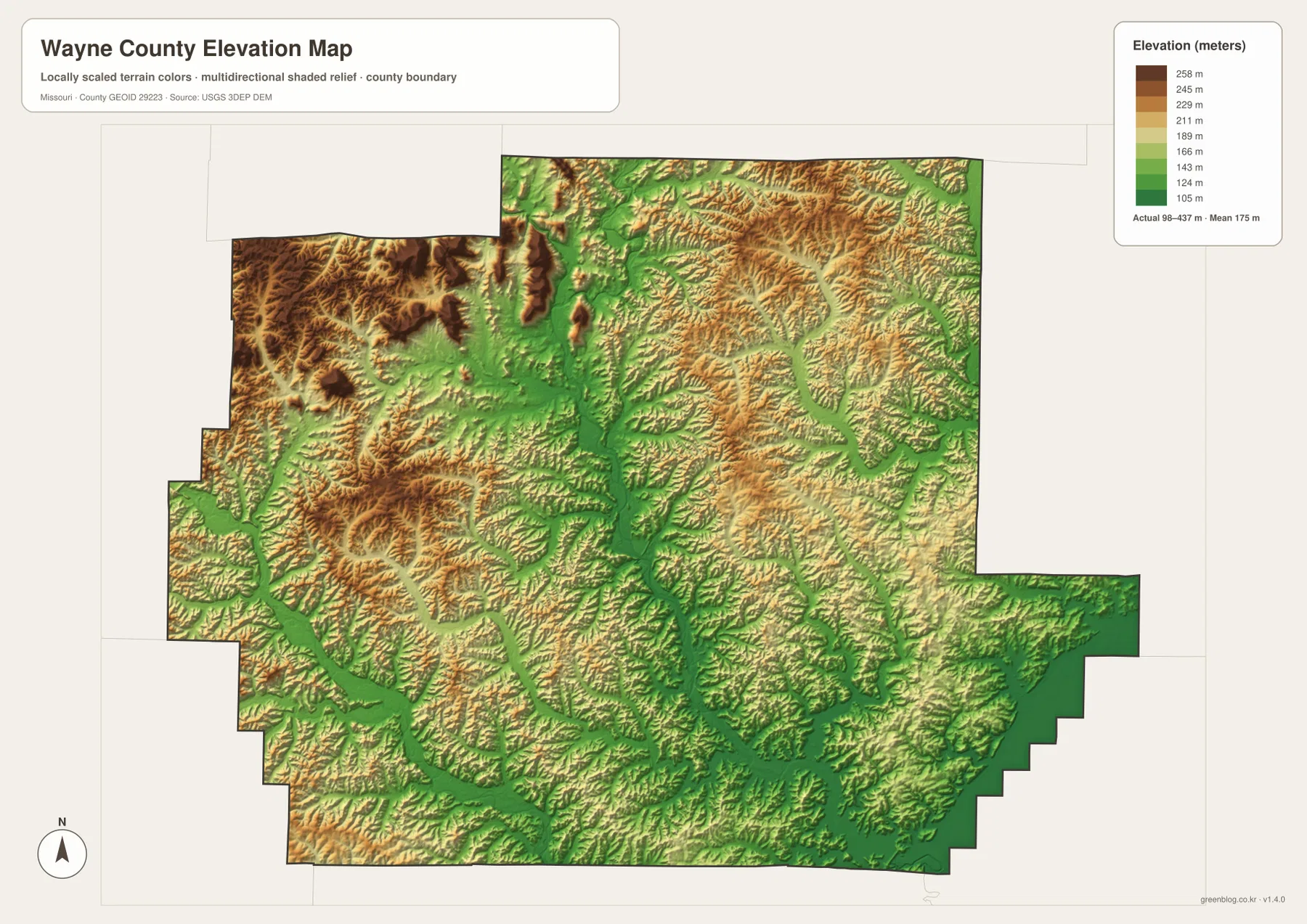
Elevation ranges from about 98 to 437 meters
The elevation map reports an actual range of roughly 98 to 437 meters and a mean near 175 meters. The highest brown terrain is concentrated in the west and northwest, with additional high ridges across the northern and northeastern interior. Some uplands rise above 400 meters, creating a very large contrast with the river valleys.
The lowest green terrain follows the St. Francis River from north to south through the center. South of Greenville, the low corridor broadens toward the upper end of Wappapello Lake. Tributary valleys branch away from this route, creating deep cuts between the surrounding ridges.
The Black River also occupies a broad lower corridor in the southwest. West and northwest of Piedmont, short ridges rise sharply above stream valleys, while the Bear Creek side in the northeast combines high uplands with deeply incised drainage. The map makes the county’s rugged Ozark relief much clearer than the road map alone.
This county-scale elevation surface is useful for broad relief comparison, not for engineering, construction, drainage design, parcel-level elevation decisions, or survey-grade measurement. Site-specific work requires more detailed official elevation data or field surveying.
Compare the Piedmont road network with river valleys and high Ozark ridges
Start with Piedmont, U.S. 67, and Route 34 when roads and settlement locations matter most. Greenville lies to the east, Mill Spring to the south, and Williamsville farther southeast. Route 143 and Route 49 then provide useful references for the northern and southern interior.
For terrain, begin with the St. Francis River, then compare Wappapello Lake to the southeast, the Black River to the southwest, and Bear Creek to the northeast. Switching to the elevation map shows that the main waterways occupy lower green corridors while western and northern ridges rise sharply above them.
Wayne County is shaped more by rivers and rugged relief than by a continuous urban network. The Piedmont–Greenville road corridor gives the map a simple first reference, but the water and elevation views reveal a much more complex landscape of high ridges, deep valleys, and the broad Wappapello Lake lowland.
The downloadable JPG originals contain more pixels than the WebP previews embedded on the page, making them better for enlargement, A3 printing, classroom handouts, reports, and personal reference. They remain general-purpose maps, however. Legal boundaries, live road restrictions, current water conditions, and precise site elevations should always be checked against current official sources.
Frequently Asked Questions
How far are Greenville, Williamsville, and Mill Spring from Piedmont?
The city map shows straight-line distances of about 14 miles from Piedmont to Greenville, 14 miles to Williamsville, and 6 miles to Mill Spring. Driving mileage can be longer because roads follow the Ozark terrain and river valleys.
How much elevation change is shown across Wayne County?
The elevation map shows an actual range of about 98 to 437 meters with a mean near 175 meters. Western and northwestern ridges are high, while the St. Francis River, Black River, and Wappapello Lake corridors are much lower.
Which waterways are the best starting points on the terrain map?
Start with the St. Francis River through the center and Wappapello Lake in the southeast. The Black River in the southwest and Bear Creek in the northeast provide strong additional references.
Map File Information
The download ZIP contains high-resolution JPG versions of the Wayne County general map, city map, terrain-and-water map, and elevation map.
- File Type: JPG
Related Maps
Sources and References
Boundary and road reference data are supported by U.S. Census Bureau TIGER/Line, water features by USGS National Hydrography, and elevation data by the USGS 3D Elevation Program. Greenville’s county-seat information is listed by the Missouri Secretary of State, and Wappapello Lake information is available from the U.S. Army Corps of Engineers.
Green Map creates custom-edited map images using open geographic data sources such as geoBoundaries, Natural Earth, OpenStreetMap, and government open data. These maps are edited visual materials, not raw data files, and are provided for education, documents, presentations, and graphic reference.