Miller County sits in central Missouri where the Osage River, Lake of the Ozarks, and a broken upland landscape shape both travel and settlement. Eldon is the clearest road hub in the northwest, Tuscumbia lies near the Osage River in the middle of the county, and Iberia anchors the southeast. Along the west, Lake Ozark and the deeply indented lake shoreline create a very different map pattern from the ridges and creek valleys farther east.
The four maps on this page separate those layers so they are easier to compare. The general map emphasizes roads, boundaries, and named places; the city map reduces the county to six major settlement references; the terrain-and-water map follows the Osage River and its tributaries; and the elevation map shows an actual range of about 162 to 339 meters. High-resolution JPG versions of all four maps are available in the ZIP download for close viewing and A3 printing.
Table of Contents
Start with the Osage River to understand the county’s shape
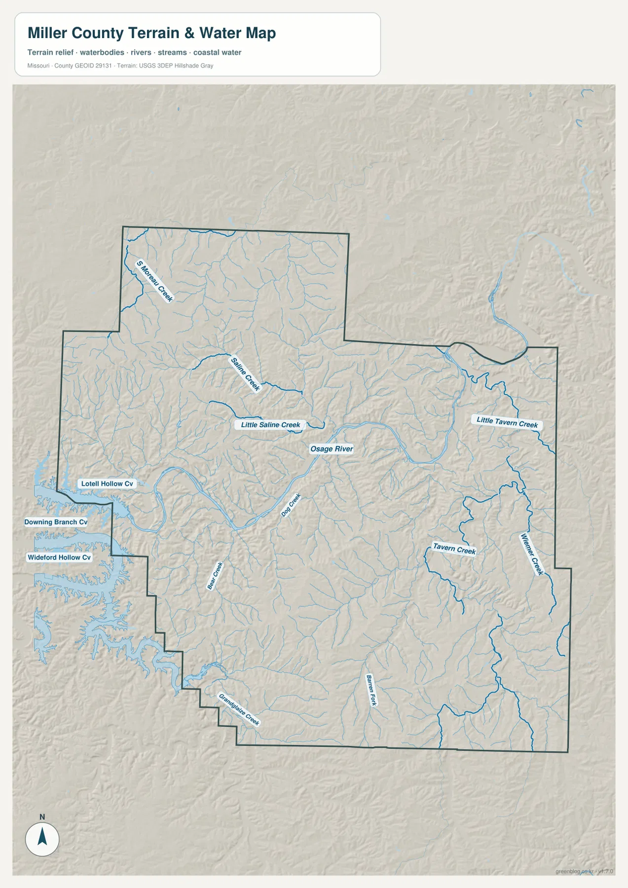
The Osage River provides the strongest natural reference on the terrain-and-water map. It bends across the central part of Miller County, passing close to Tuscumbia before continuing east. Saline Creek and Little Saline Creek approach from the north and northwest, while Doan Creek and numerous unnamed tributaries descend from the surrounding ridges. The main river valley is broad enough to remain obvious even when the finer drainage lines become dense.
The western edge has a second water pattern: narrow arms and coves connected with Lake of the Ozarks. Labels such as Lotell Hollow Cove, Downing Branch Cove, and Wideford Hollow Cove show how deeply the water reaches into the western hills. A place can therefore look close in a straight line while a road trip around the shoreline requires a much longer route. The water map is useful for geographic context, but it should not be treated as a boating chart or a current navigation source.
Smaller streams divide the rest of the county into many short ridges. Shawnee Creek and Saline Creek are prominent in the north, while Little Tavern Creek, Tavern Creek, and Wiemer Creek mark the east. Barren Fork and Brush Creek appear farther south, and Grandglaize Creek helps identify the southwestern drainage. The important visual point is not the number of stream names but the way nearly every upland block is cut by one or more narrow valleys.
Lake of the Ozarks State Park lies near Brumley on the lake side of the county. Missouri State Parks describes a landscape of wooded ground, small springs, streams, and extensive lake frontage, which matches the mixture visible on the water and relief maps. For flood risk, water level, water quality, or legal access questions, use current information from USGS and the responsible state or local agency instead of this county-scale reference map.
Eldon, Tuscumbia, and Iberia create a practical road frame
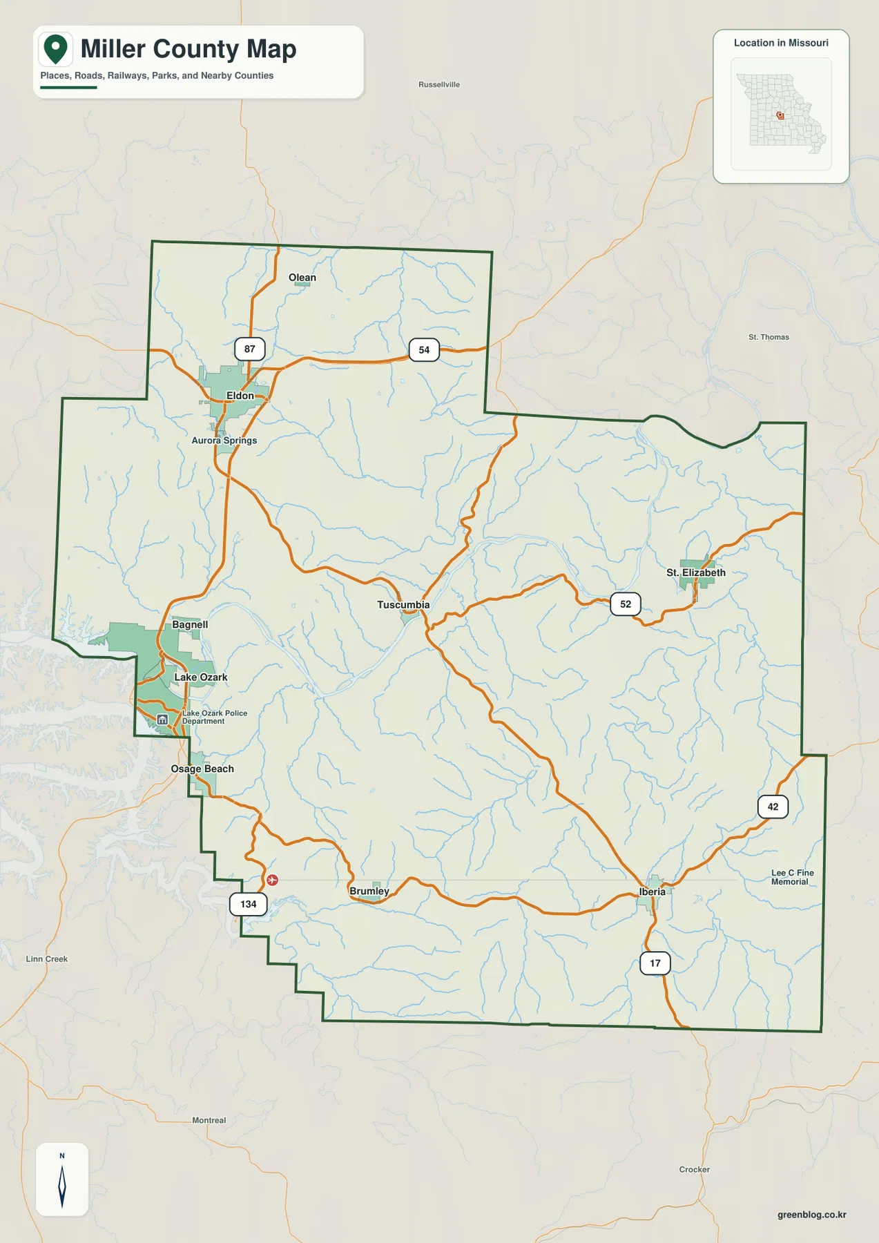
On the general map, Eldon is the strongest transportation reference in the northwest. U.S. 54 passes the city from west to east, and Missouri Route 87 approaches from the north near Olean. From the Eldon area, roads continue south toward Bagnell and Lake Ozark, while routes to the east lead into the central part of the county. This makes Eldon a useful first point for orienting the road network before tracing smaller rural roads.
Tuscumbia occupies a different setting. It is near the Osage River and serves as the Miller County seat, a role documented in Missouri state records. The roads around Tuscumbia respond to the river and the surrounding hills, so they curve more frequently than the straighter road segments found in parts of the northwest. Moving east, Route 52 helps locate St. Elizabeth and links the central river area with the eastern side of the county.
Iberia is the main southeastern reference, near Routes 17 and 42. Route 134 is more useful on the southwest side near Brumley and the Lake of the Ozarks State Park area. These numbered routes do not form one neat grid across the county because the river, reservoir shoreline, and numerous creek valleys interrupt straight travel. Comparing them with the water map makes the changes in road direction much easier to explain.
The general map is best used as a county-scale orientation product. It shows how roads, named places, streams, and the boundary fit together, but it does not report construction, closures, traffic, private-road restrictions, or travel time. Those questions require a current transportation or navigation source. Here, the value is seeing how Eldon, Tuscumbia, Iberia, Lake Ozark, and the surrounding routes occupy the same landscape.
Six settlement markers spread across a large rural county
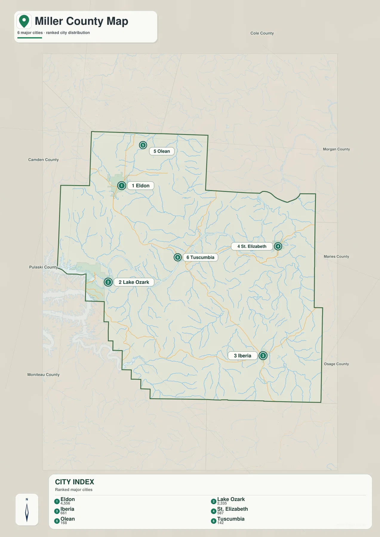
The city map strips away much of the road detail and highlights six named places: Eldon, Lake Ozark, Iberia, St. Elizabeth, Olean, and Tuscumbia. Olean sits in the northwestern extension, with Eldon directly to its south. Lake Ozark is farther down the western side, Tuscumbia is near the middle, St. Elizabeth is east of center, and Iberia is in the southeast. Their spread shows why a single town cannot describe the county’s geography.
Eldon and Lake Ozark form the most obvious western pair, but they serve different map-reading purposes. Eldon is tied to the U.S. 54 corridor and the broader inland road network, whereas Lake Ozark is a reference for the reservoir edge and the recreation-oriented western side. The more detailed map adds Bagnell and Aurora Springs between and around these points, helping connect the simplified city view with the full road map.
Tuscumbia, St. Elizabeth, and Iberia form a looser central-to-southeastern sequence. Tuscumbia is close to the river, St. Elizabeth sits along Route 52, and Iberia is farther south near Routes 17 and 42. They are separated by ridges, tributaries, and rural roads rather than merging into a continuous urban area. That spacing is one reason the city map is useful: the county-wide relationships remain clear without every minor road competing for attention.
Miller County was organized in 1837 from parts of Cole and Pulaski counties and was named for John Miller, a former governor of Missouri. The historical detail does not change how the map is read, but it adds context to Tuscumbia’s long-standing administrative role. For modern map use, position matters most: each town works as a reference point for nearby highways, creek valleys, and the county boundary.
A 162–339 meter range reveals the river lowlands and dissected uplands
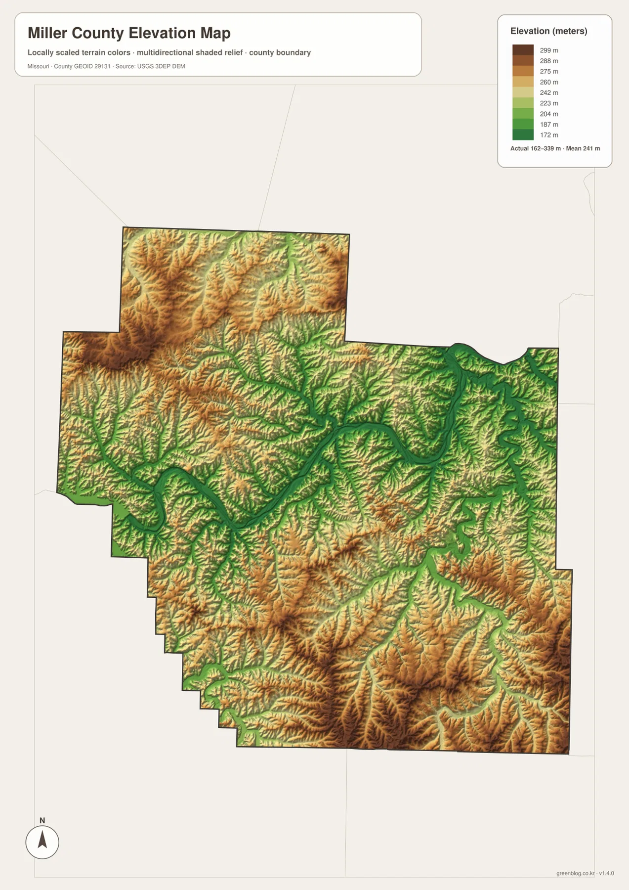
The elevation map reports an actual county range of roughly 162 to 339 meters, with a mapped mean near 241 meters. Greens mark the lower terrain, and the most continuous green corridor follows the Osage River across the center. Yellow, orange, and brown areas climb away from that corridor into the surrounding hills. The difference is large enough that river bottoms and ridge tops remain distinct even at county scale.
North and northwest of the main river, higher ground is extensive around and beyond the Eldon area. Narrow green tributary valleys slice through these uplands, creating a branching pattern rather than one smooth slope. South of the Osage River, the relief becomes equally broken: ridges rise between drainage lines, then descend again toward streams on the way to Brumley, Iberia, and the southern boundary.
The eastern side around St. Elizabeth is also heavily dissected. Tavern Creek and Wiemer Creek occupy lower corridors, while intervening ridges appear in warmer colors. Around Iberia, roads cross a mixture of higher ground and stream valleys rather than a broad flat plain. The elevation layer therefore explains why the road network bends and why settlements that look near each other on the city map may be separated by more complicated terrain.
This surface is designed for regional comparison, not engineering or parcel work. A color band should not be used as the exact elevation of a house site, bridge, culvert, or property corner, and it does not measure road grade. For precise elevations, the USGS 3D Elevation Program is the appropriate starting point. The county map is most useful for recognizing the contrast between the low Osage River corridor and the surrounding Ozark uplands.
Choose the map by the question you are trying to answer
If your question is about how to move across the county, begin with the general map. It shows U.S. 54, the major state routes, named places, and the county outline in one view. If the goal is to teach or present the relative location of Eldon, Lake Ozark, Tuscumbia, St. Elizabeth, Iberia, and Olean, the city map is cleaner because it removes much of the secondary detail.
For natural geography, the terrain-and-water map should come next. It makes the Osage River, Lake of the Ozarks coves, Saline Creek, Tavern Creek, and the many smaller tributaries easier to follow. The elevation map answers a different question by showing which valleys are lower and which ridges rise above them. Using the two together prevents a stream line from being read as an isolated feature with no surrounding terrain.
The western lake area is a good example of why one map is not enough. The city map quickly identifies Lake Ozark; the road map shows how it connects with Eldon, Bagnell, and Route 134; the water map reveals the maze of coves; and the elevation map shows steeply changing terrain behind the shoreline. Tuscumbia offers a second comparison, combining county government, a river crossing area, and one of the broadest low corridors on the elevation map.
For printing, the downloadable JPG files preserve more detail than the WebP previews used in the article. Each original is 2572 by 3638 pixels, which is suited to enlarged viewing and A3 layouts. Use the general map when labels and roads matter most, the city map for a simplified location overview, the water map for rivers and lake arms, and the elevation map when relief is the main subject.
Frequently Asked Questions
What is the county seat of Miller County, Missouri?
Tuscumbia is the county seat. On the maps it lies near the Osage River in the central part of the county, between the Eldon/Lake Ozark side and the St. Elizabeth/Iberia side. Missouri state and county reference sources identify Tuscumbia as the county’s administrative center.
Why is the central green corridor so prominent on the elevation map?
The broad green band follows the Osage River valley, which is lower than many of the surrounding ridges. Smaller green branches extend up tributary valleys such as Saline Creek and Tavern Creek. Comparing the elevation and water maps makes that relationship much easier to see.
Which map is most useful for the Lake Ozark side of the county?
Use the general map first if you need roads and place names, then compare it with the terrain-and-water map to understand the reservoir coves and tributaries. The elevation map is useful when you also want to see how quickly the land rises away from the shoreline and river valleys.
Map File Information
The download ZIP contains high-resolution JPG versions of the Miller County general map, city map, terrain-and-water map, and elevation map.
- File Type: JPG
Related Maps
Sources and References
- Missouri Association of Counties – Miller County
- Missouri Secretary of State – Origins of Missouri Counties
- Missouri State Parks – Lake of the Ozarks State Park
- USGS National Hydrography
- USGS 3D Elevation Program
- U.S. Census Bureau TIGER/Line Shapefiles
Green Map creates custom-edited map images using open geographic data sources such as geoBoundaries, Natural Earth, OpenStreetMap, and government open data. These maps are edited visual materials, not raw data files, and are provided for education, documents, presentations, and graphic reference.