Marion County occupies a distinctive corner of northeastern Missouri where inland ridges descend toward the Mississippi River. Hannibal sits near the river in the southeast, while Palmyra lies farther inland to the northwest, and U.S. 61 provides an easy north-south reference between the two parts of the county. West of that corridor, the map becomes more finely cut by tributaries and short ridges. This page brings the boundary, city, water, and elevation views together, and the original high-resolution JPG map files are available to download below.
A useful way to orient yourself is to find Hannibal, Palmyra, and the Mississippi River first. Route 6, Route 168, and the U.S. 24/36 corridor then provide additional road references, while the water map shows the North Fabius, Fabius, North, and South rivers crossing the county toward lower ground in the east. The elevation layer ranges from about 139 to 237 meters and makes the east-west contrast especially clear: broad low terrain follows the Mississippi side, while more dissected uplands occupy much of the western half.
Table of Contents
Hannibal, Palmyra, and the U.S. 61 corridor
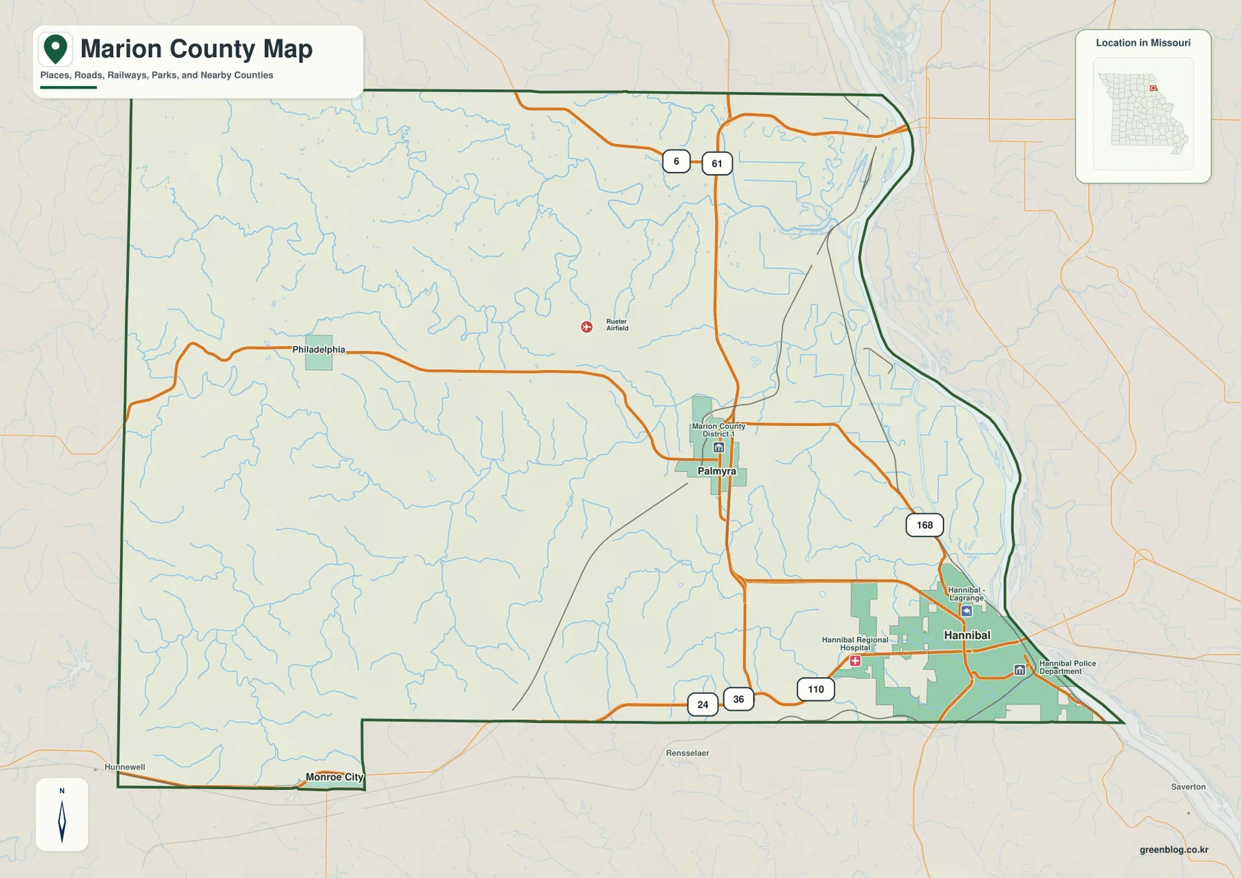
The general county map is the best starting point because it places roads, towns, rail lines, streams, and the county outline on one page. Hannibal is easy to spot in the southeast close to the Mississippi River, and Palmyra appears inland to the northwest. U.S. 61 runs north-south through the eastern side of the county, giving the reader a simple line of reference before looking at smaller roads. Near the north, Route 6 crosses the same part of the county, while Route 168 connects the Palmyra area toward Hannibal.
Along the southern side, U.S. 24 and U.S. 36 are labeled near the county edge, and Route 110 appears west of Hannibal. Philadelphia provides a useful landmark in the western interior, while Monroe City sits near the southwest boundary. These places help show how strongly the county’s settlement pattern leans toward the eastern corridor even though local roads and smaller communities extend far into the uplands to the west.
The eastern boundary is unlike the straighter county lines on the north and west. It follows the Mississippi River, so the outline bends with the river and widens around low floodplain terrain before narrowing again near the southeast. That shape is useful when comparing Marion County with neighboring counties and with Illinois across the river. The map is not a live navigation product, but it works well for understanding where the major roads, communities, streams, and boundary lie relative to one another.
Marion County’s official website identifies Palmyra as the county seat and also notes a courthouse in Hannibal. That local arrangement fits the geography visible on the map: Palmyra is an inland administrative center, while Hannibal is the larger river-side urban center. Looking at both places together gives a more useful picture of the county than treating either one as the only point of reference.
Two major city markers reveal an east-side concentration
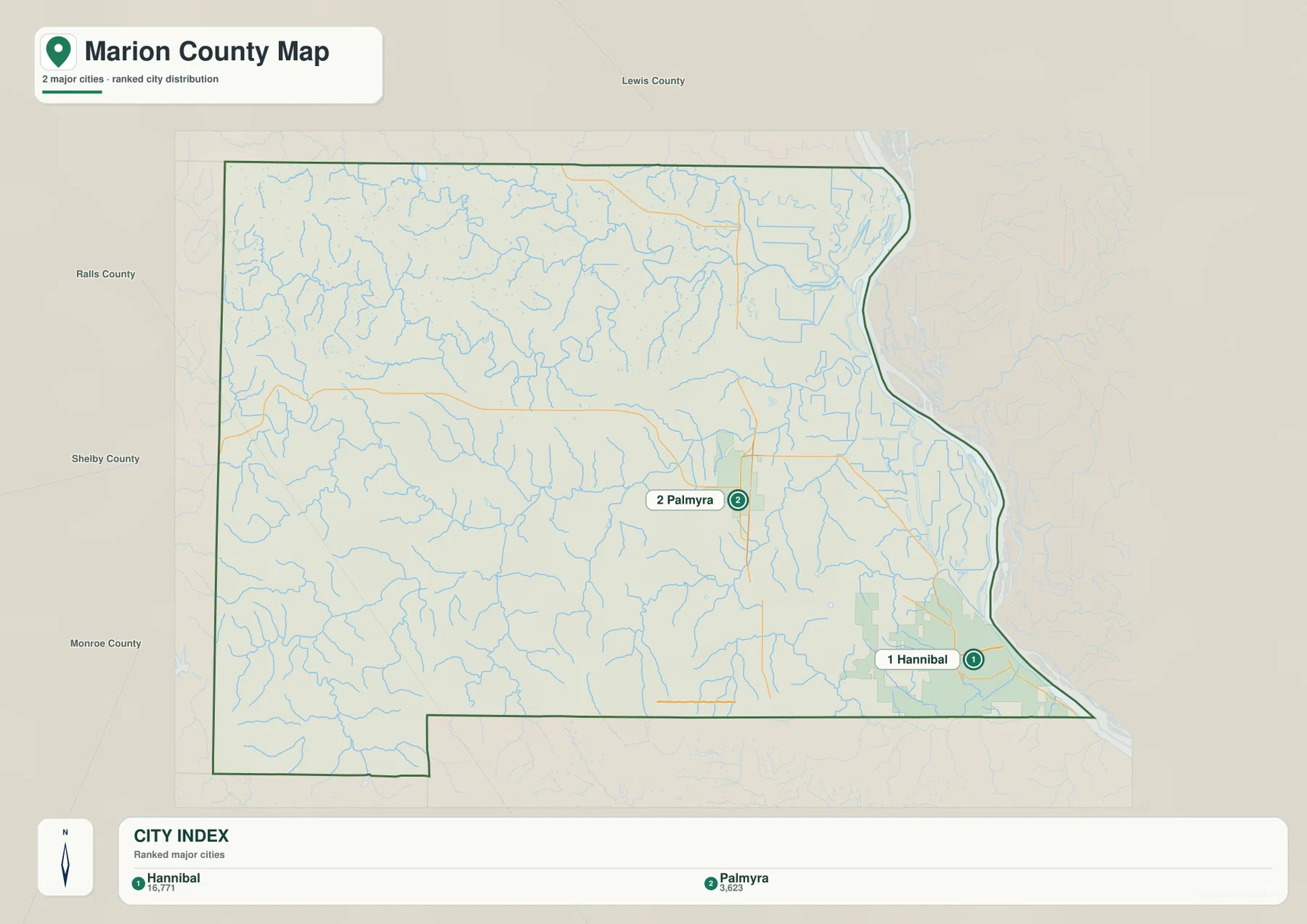
The city-focused map removes much of the road detail and emphasizes two places: Hannibal and Palmyra. Its city index shows Hannibal at 16,771 and Palmyra at 3,623. Those figures should be treated as the values printed in the supplied map rather than as a substitute for the latest Census estimate, but they clearly convey the difference in scale between the two highlighted centers. More importantly for map reading, they show where those centers sit inside the county.
Hannibal spreads across the southeastern corner close to the Mississippi corridor. Roads and rail lines converge around the city, and the county boundary turns along the river immediately to the east. Palmyra is smaller and farther inland, positioned near U.S. 61 and east-west local routes. The separation between the two gives Marion County a two-center pattern rather than a single town surrounded by evenly distributed rural settlement.
The western half looks very different. Large city symbols disappear, while streams, smaller roads, and open rural areas dominate the map. Philadelphia is visible on the general county map and helps orient the west-central area, and Monroe City touches the southwest edge. Together, these locations show that the county extends well beyond the Hannibal-Palmyra corridor even though its most prominent city labels are concentrated closer to the Mississippi side.
Official Census reference mapping places Lewis County to the north, Shelby County to the west, Monroe County to the southwest, and Ralls County to the south, with Illinois across the Mississippi River to the east. This wider context is helpful when the county map is being used for regional orientation. It also explains why the river edge is more than a scenic feature: it is the county’s eastern state boundary as well.
From the Fabius rivers to the Mississippi floodplain
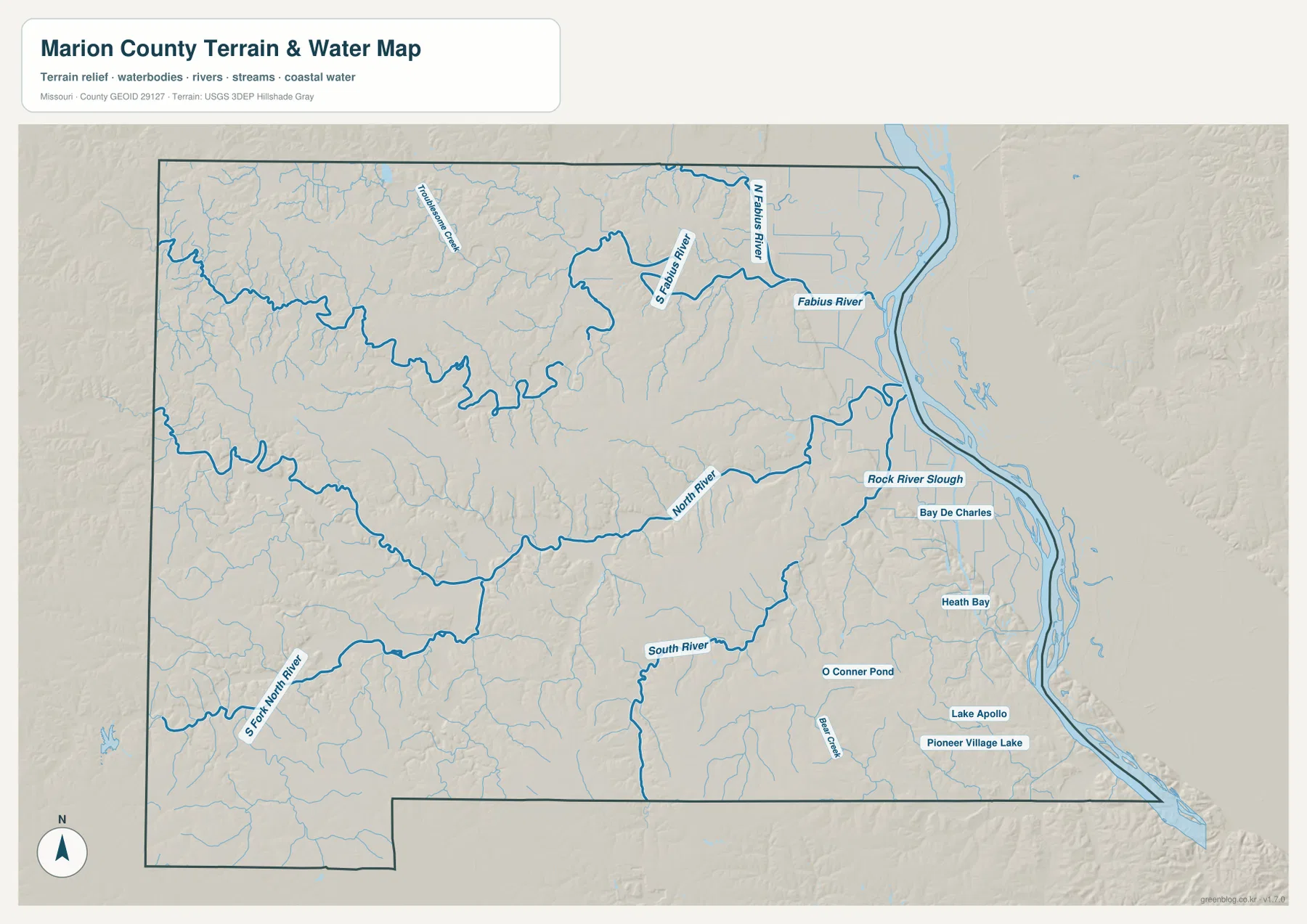
The terrain-and-water map makes the Mississippi River the dominant feature along the eastern edge. Inland, the North Fabius River and Fabius River cross the northern part of the county, with the South Fabius River joining the same broader drainage system. Smaller tributaries branch through the uplands before reaching those larger channels. Following them from west to east is one of the clearest ways to see how water has divided the interior into many short ridges and valleys.
Farther south, the North River curves across the middle of the county, and the South River occupies a separate valley below it. The South Fork North River is labeled in the southwest, so similar river names need to be matched carefully with their positions. Troublesome Creek and Bear Creek add smaller named channels, while many unnamed tributaries fill the spaces between them. The pattern is dense enough that even areas far from the Mississippi are strongly shaped by stream valleys.
The river margin introduces a different set of water features. Rock River Slough, Bay De Charles, and Heath Bay appear in the low eastern zone, while O Connor Pond, Lake Apollo, and Pioneer Village Lake are labeled in the southeast interior. These features contrast with the narrow branching creeks of the western uplands and help explain why the land next to the Mississippi looks broader and flatter on both the terrain and elevation maps.
This map is intended for geographic reference, not for flood-risk, water-depth, navigation, or water-quality decisions. Conditions along the Mississippi River and smaller tributaries can change, and the map does not show current river stages or legal access. Its value is in showing where the major channels lie, how smaller streams feed them, and how the water network relates to Hannibal, Palmyra, and the surrounding roads.
A 139–237 meter range separates the river lowland from western ridges
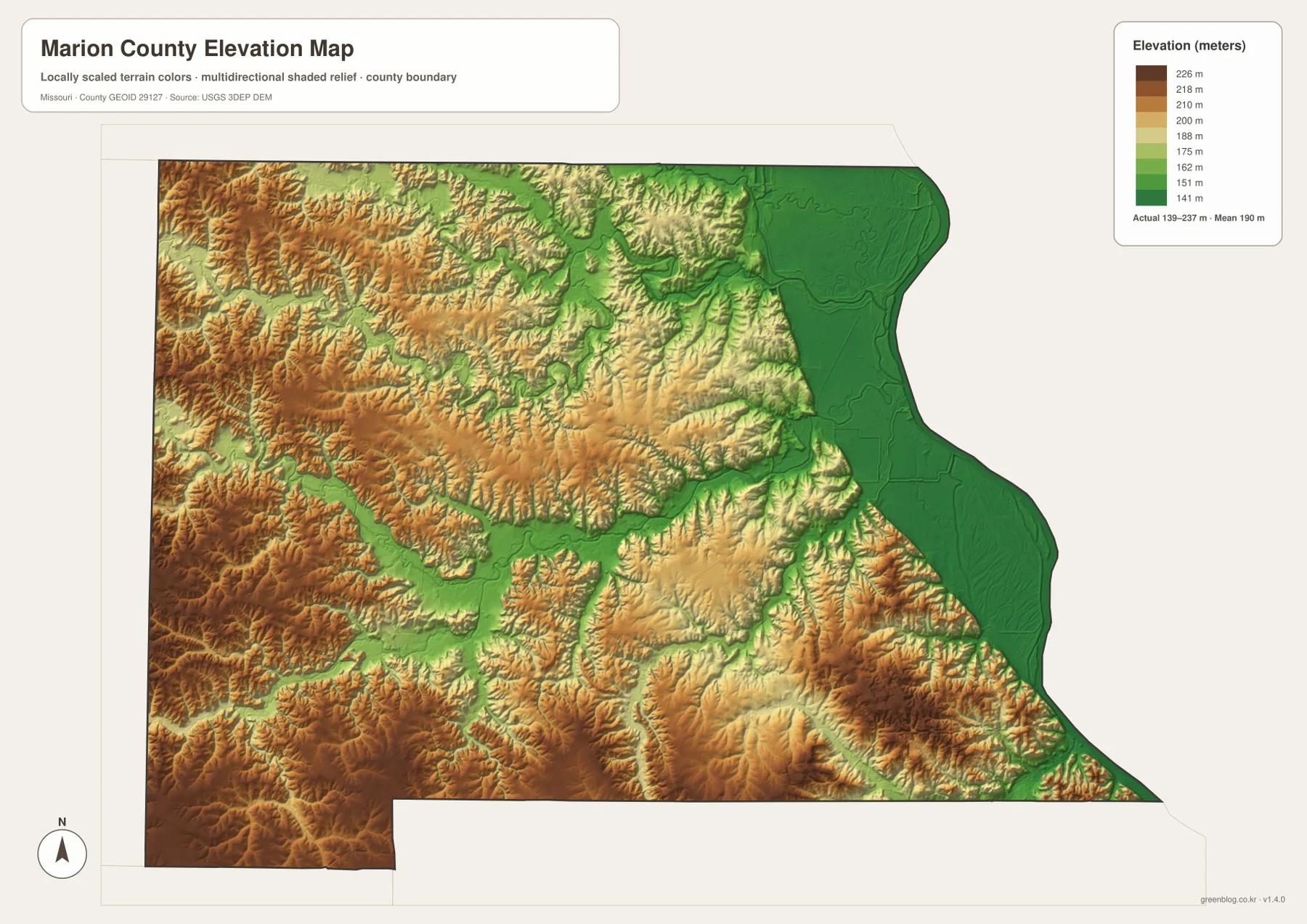
The elevation map lists an actual range of roughly 139 to 237 meters, with a mean near 190 meters. Low greens dominate the Mississippi side of the county, while yellows, oranges, and browns become more common toward the west and southwest. Marion County is not mountainous, but the nearly 100-meter difference is expressed through frequent short ridges and incised valleys rather than one simple slope.
The broadest low terrain follows the eastern river margin. Around Hannibal, lower ground extends along the Mississippi, then gives way to rising terrain a short distance inland. Palmyra sits farther from the main floodplain, near the transition between the broad eastern lowland and more rolling country to the west. Comparing the road map with the elevation view helps explain why the eastern transportation corridor is visually simpler than many of the smaller roads farther inland.
Western and southwestern Marion County show a much tighter pattern of ridges and valleys. Brown and orange uplands are cut by narrow green channels that correspond to the North River, the South Fork North River, and numerous tributaries. Roads in this part of the county often bend or change direction as they cross those valleys. The elevation layer therefore adds useful context that cannot be seen from road lines alone.
The Fabius drainage in the north produces another set of lower corridors, but these valleys are narrower than the broad Mississippi lowland. Thin green bands follow stream courses and are separated by higher ridges. Switching between the water and elevation maps makes this relationship easy to verify because many of the low bands line up directly with named rivers and creeks.
The shaded elevation surface is meant for county-scale comparison, not survey-grade measurement. It should not be used to determine the exact elevation of a building site, road grade, bridge, or parcel. Engineering, construction, and detailed terrain work require more precise source data such as the USGS 3D Elevation Program. Here, the map is most useful for recognizing the broad Mississippi lowland and the increasingly broken uplands to the west.
Reading the same places across boundary, city, water, and elevation views
Hannibal is a good place to see why the four views complement one another. The general map places the city beside U.S. 61, Route 168, Route 110, rail lines, and the Mississippi River. The city view strips away much of that detail and emphasizes Hannibal’s position as the larger highlighted center. On the water map, river-side sloughs and bays become more obvious, while the elevation layer shows the sharp transition from low river terrain to higher ground immediately inland.
Palmyra provides a different comparison. It appears as an inland road center on the general map and as the second highlighted place on the city map. The water layer shows that it is separated from the Mississippi by a network of smaller tributaries rather than sitting directly on the main river, and the elevation view places it above the broadest eastern lowland. Those differences help explain why Hannibal and Palmyra feel geographically distinct despite being the county’s two best-known centers.
For the western interior, start with Philadelphia on the general map and then find the North River on the water layer. The surrounding terrain is cut by many feeder streams, and the elevation map shows narrow low valleys between repeated ridges. That comparison is more informative than simply calling the western county “higher,” because it reveals how frequently the surface rises and falls over relatively short distances.
Choosing a map for print or study is straightforward once the purpose is clear. Use the general county map when roads, communities, and boundaries need to appear together. The city view is cleaner when the goal is to compare Hannibal and Palmyra. The water layer is better for river and tributary names, while the elevation map makes the Mississippi lowland and western ridges immediately visible without the distraction of many road labels.
Using the web previews and original JPGs for different tasks
The WebP images in the article are sized for quick viewing in a browser, while the downloadable originals are 3638×2572-pixel JPG files. The larger files are preferable when road numbers, small stream names, or elevation detail need to remain legible in a print layout. They also provide more room for cropping or placing the map in an A3 document without relying on the smaller web preview.
For a first look at the county, begin with Hannibal and Palmyra and use the Mississippi River as the eastern reference line. If the area of interest is west of those cities, move to the North River and the ridge pattern shown on the elevation map. For the southeast, compare Hannibal with the river-side sloughs, bays, and low terrain. Because all four maps use the same county outline, a location found on one view can be transferred to the others without much difficulty.
These maps should not replace current legal, safety, or engineering information. Parcel ownership, surveyed property lines, flood zones, road closures, navigability, and construction elevations require current authoritative records. The maps are best used to establish geographic context first, then followed by county, Census, USGS, or transportation sources when a decision depends on up-to-date or legally precise information.
Frequently Asked Questions
Which map best shows the difference between the Mississippi lowland and the western uplands?
The elevation map shows that contrast most clearly. Low green terrain follows the Mississippi River along the eastern edge, while progressively higher and more dissected ground appears toward the west. Pair it with the terrain-and-water map to see how the North River, South River, Fabius channels, and smaller tributaries occupy many of the lower valleys.
What is the easiest way to compare Hannibal and Palmyra?
The city map is the cleanest choice when only the locations of the two major centers matter. Hannibal is highlighted in the southeast near the Mississippi River, and Palmyra is farther inland to the northwest. To add transportation context, switch to the general county map and follow U.S. 61 and Route 168 between the two areas.
What files are included in the download ZIP?
The archive contains four high-resolution JPG files: the general county map, city map, terrain-and-water map, and elevation map. Each original is 3638×2572 pixels, giving more detail than the WebP previews shown in the article and making the files more suitable for larger print layouts or document editing.
Map File Information
The download ZIP contains the Marion County general map, city map, terrain-and-water map, and elevation map as high-resolution JPG files.
- File Type: JPG
Related Maps
Sources and reference links
For county administration, current statistics, boundaries, hydrography, and elevation source data, these official references provide additional detail beyond the map images on this page.
- Marion County, Missouri official website
- U.S. Census Bureau QuickFacts – Marion County, Missouri
- U.S. Census Bureau TIGER/Line Shapefiles
- USGS National Hydrography
- USGS 3D Elevation Program
Green Map creates custom-edited map images using open geographic data sources such as geoBoundaries, Natural Earth, OpenStreetMap, and government open data. These maps are edited visual materials, not raw data files, and are provided for education, documents, presentations, and graphic reference.