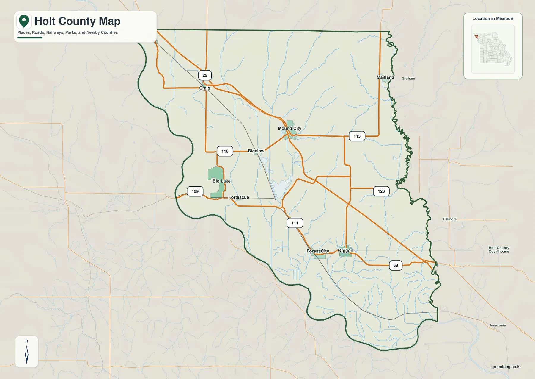
Holt County sits in Missouri’s far northwest, where the flat Missouri River plain ends abruptly against deeply cut loess hills. Mound City and Oregon are the two easiest towns to anchor the map, with Craig, Maitland, Forest City, and Big Lake spread across the rest of the county. I-29, U.S. 59, and Routes 111, 113, 118, 120, and 159 connect those places, while Tarkio River, Little Tarkio Creek, Nodaway River, and Big Lake reveal a second network of low corridors. The downloadable ZIP includes high-resolution JPG versions of the maps shown here, so labels and terrain details can be enlarged or printed.
The county’s most striking feature is the sequence from west to east. Big Lake and the Missouri River bottomlands occupy broad, low ground; the interior then rises quickly into narrow loess ridges and creek-cut valleys; finally, the land drops again toward the Nodaway River along the eastern edge. That three-part arrangement explains much of Holt County’s road pattern, settlement spacing, and terrain.
Table of Contents
Begin with Mound City and the I-29 corridor
Mound City lies slightly north of the county’s center and sits close to I-29, making it a practical starting point for the northern and central areas. Route 113 leads east and northeast from town, while Route 111 helps orient the interior farther south. Craig is farther northwest, and Big Lake and Bigelow sit out in the lower western country.
Oregon and Forest City occupy the southern half, with U.S. 59 serving as an important road reference around Oregon. Holt County does not have a continuous urban strip; towns are separated by farmland, floodplain, creek valleys, and ridges. Looking at Mound City, Oregon, Craig, and Forest City together gives a better sense of the county’s full width and length than treating any one town as the entire story.
Oregon marks the county seat while Mound City marks a terrain break
The Holt County Courthouse is in Oregon, so county government is centered there. Mound City has a different importance on the map: it is close to I-29 and near the sharp transition from the Missouri River plain to the loess uplands. The two towns therefore frame two different parts of county life—administration in Oregon and a major travel-and-terrain reference around Mound City.
Oregon stands between the higher interior and the lower Nodaway River corridor to the east. Mound City, by contrast, is close to the western floodplain edge, where low ground gives way quickly to steep, dissected hills. Following both places across the water and elevation maps shows how closely Holt County’s towns relate to the land beneath them.
Six ranked communities show how widely settlement is spread
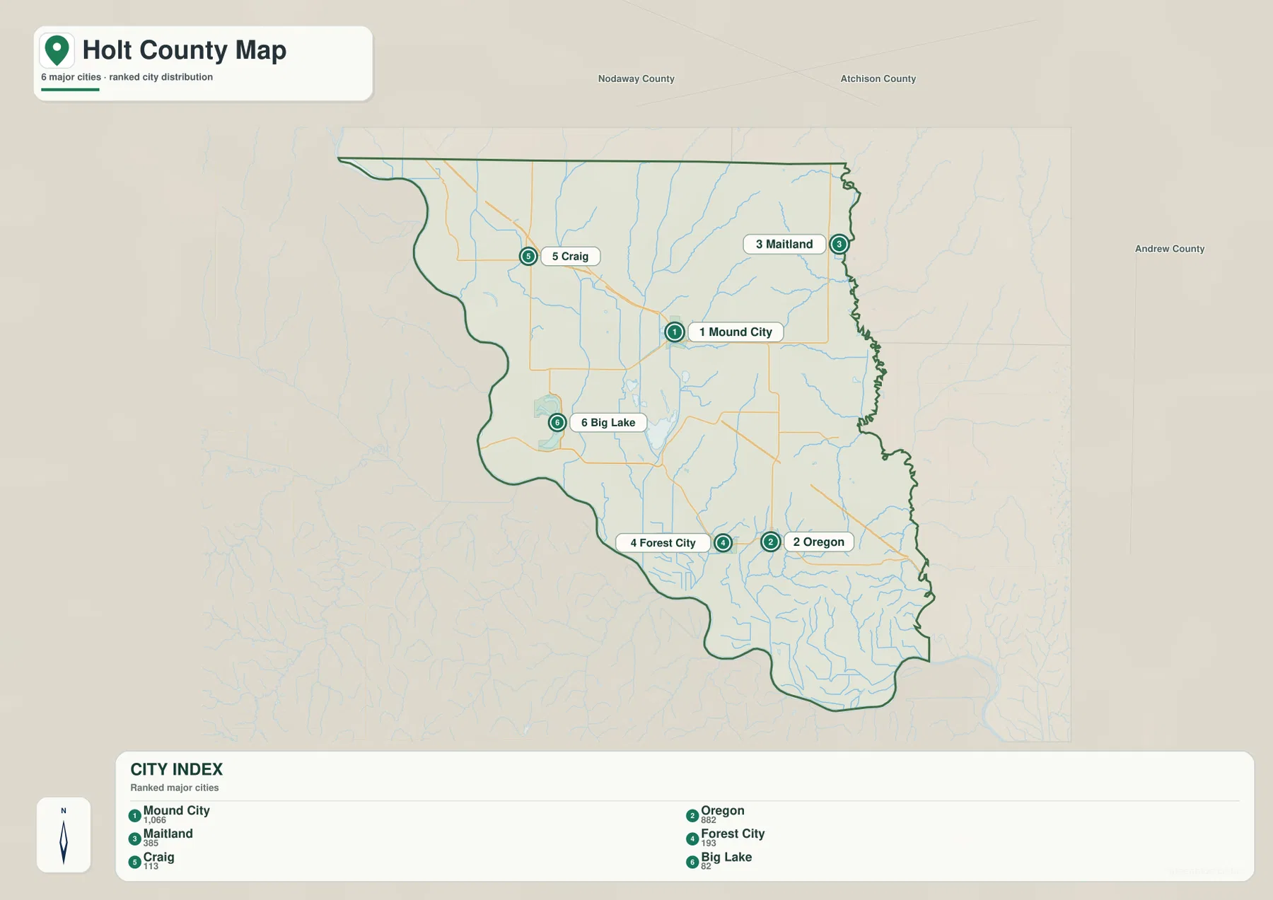
The city layer ranks Mound City first, Oregon second, Maitland third, Forest City fourth, Craig fifth, and Big Lake sixth. Its CITY INDEX displays 1,066, 882, 385, 193, 113, and 82 respectively. Those figures belong to the supplied ranking dataset and are not presented here as current official population estimates.
Their positions matter more than the values. Mound City is north-central, Craig is northwest, Maitland is northeast, Big Lake is west-central, and Forest City and Oregon are farther south. The markers indicate rank, not mileage or travel time.
Big Lake sits inside the broad Missouri River lowland
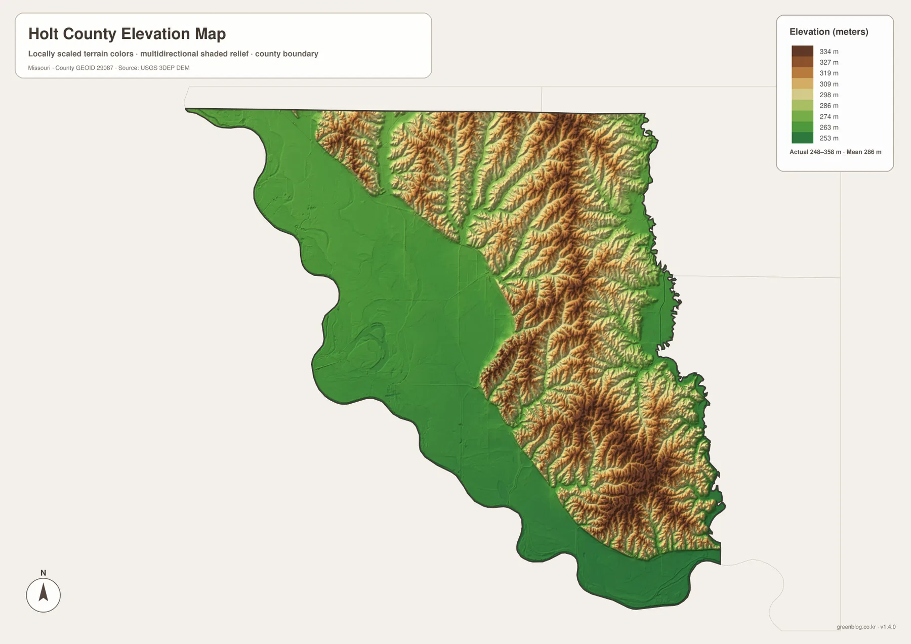
West and southwest Holt County form a wide, low plain on the elevation map. Big Lake and the Fortescue area lie within this lower ground, and relief remains gentle compared with the hills immediately to the east. The county’s western outline also bends rather than following a simple straight boundary because it follows the Missouri River side of the landscape.
The county’s official material describes Missouri River floodplain, steep river bluffs, and high glacial prairie within Holt County. Those terms become concrete on the map: green lowlands dominate the west, while tan and brown slopes begin only a short distance inland. Few parts of the county show that shift as clearly as the area between Big Lake, Mound City, and Forest City.
Tarkio River and Little Tarkio Creek split the northwest into parallel valleys
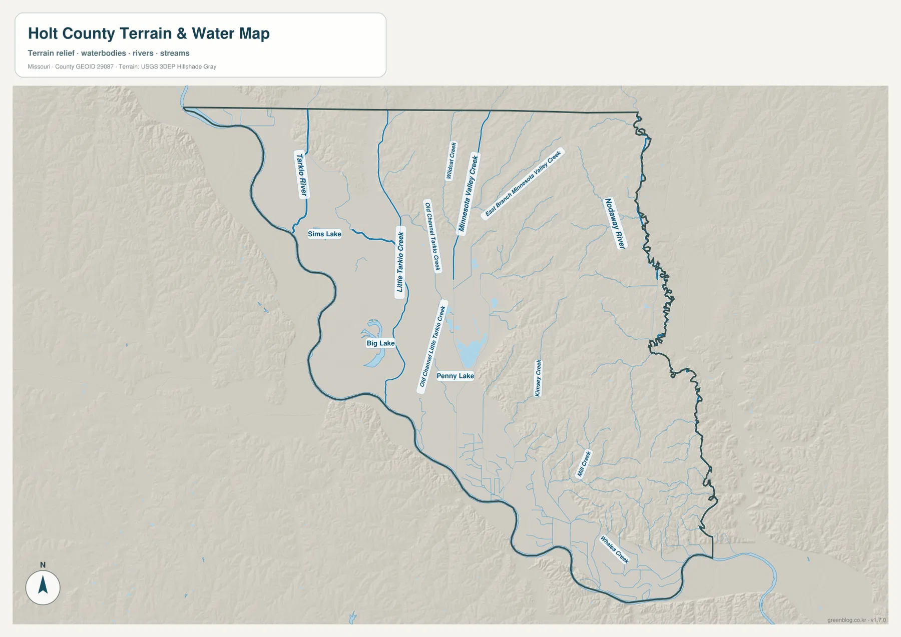
Tarkio River descends through the northwestern part of the county, with Sims Lake labeled nearby. Little Tarkio Creek follows a separate corridor to the east, and Big Lake occupies a broader low area farther south. Together they form several north-south drainage routes across the western half rather than one single channel.
Old Channel Little Tarkio Creek and Old Channel Mill Creek also appear on the water map. Their names point to older channel traces in the lowland. They are useful geographic labels, but the map does not describe current flood hazard, active channel movement, or drainage-management conditions.
Nodaway River cuts a second low corridor along the east
Nodaway River runs close to the eastern county line and creates a low route near Maitland in the northeast and east of Oregon farther south. The elevation map shows the eastern edge dropping back into green terrain after the higher interior ridges, so Holt County is not simply a steady climb from west to east.
Minnesota Valley Creek and East Branch Minnesota Valley Creek occupy long valleys west of the Nodaway. Kinnery Creek, Mill Creek, and Whitten Creek add more narrow cuts farther south. These waterways divide the loess uplands into separate ridges and make the eastern interior much more broken than a broad agricultural plain.
Loess Bluffs south of Mound City rise directly above the floodplain
Loess Bluffs National Wildlife Refuge lies south of Mound City where the Missouri River floodplain meets the loess hills. U.S. Fish & Wildlife Service describes the refuge as a mixture of wetlands, grasslands, forest, and loess-hill habitat. The setting helps explain why low, open ground and steep ridges appear so close together on the supplied maps.
Missouri Department of Conservation gives similar local context at Jamerson C. McCormack Conservation Area. Thick wind-deposited loess has been eroded into steep slopes and narrow valleys. On the map, the transition is especially strong around Mound City, Forest City, and Route 159, where western lowlands give way to much rougher terrain.
The 248–358 meter range captures a sharp west–east contrast
The elevation layer spans approximately 248 to 358 meters, with a mean near 286 meters. Much of the Missouri River plain sits near the lower end of that range, while interior and northeastern ridges often rise above 300 meters. The difference occurs over a relatively short distance, which is why the terrain change appears so dramatic on a county-scale map.
The uplands are broken into many ridges rather than one continuous crest. Minnesota Valley Creek, Kinnery Creek, and other tributaries carve lower green corridors between them, and the land then descends again toward the Nodaway River. These elevations are suitable for broad geographic comparison, not construction, surveying, or engineering decisions.
Big Lake and Loess Bluffs show the county’s lowland–upland boundary at close range
Big Lake lies in the west-central lowland and is easy to match between the general and water maps. South of Mound City, wetlands and other floodplain habitats occupy the same low setting, while loess ridges rise immediately to the east. That short transition is one of the best places to understand Holt County’s geography without having to compare distant parts of the county.
For current visitor or habitat information, the official Loess Bluffs refuge page and Missouri Department of Conservation pages are the appropriate sources. The maps here add county-scale context by showing how those protected areas sit between the Missouri River plain, nearby towns, and the higher interior.
Match the file to the detail you need
For roads and town names, start with the general county map. The ranked city layer makes the spacing of Mound City, Oregon, Maitland, Forest City, Craig, and Big Lake easier to compare. The terrain-and-water map carries the most detail for Tarkio River, Little Tarkio Creek, Nodaway River, Big Lake, and the interior creeks. The elevation map is the clearest choice when the question is why western Holt County looks flat while the interior rises into sharp loess ridges.
The ZIP contains high-resolution JPG files for the same map subjects. They can be enlarged when small labels matter or printed for offline reference. For live traffic, flood alerts, legal parcel boundaries, or engineering elevations, use the relevant current official source rather than these general reference maps.
Frequently Asked Questions
Should I use Mound City or Oregon as my main reference point?
Mound City works well for I-29, Big Lake, and the floodplain-to-loess transition. Oregon is better for county government and the eastern side near the Nodaway River. Using both gives a clearer picture of Holt County than relying on either town alone.
Why does the land rise so abruptly east of the Missouri River plain?
The western side is a broad river floodplain, while thick deposits of wind-blown loess immediately to the east have been cut into steep ridges and valleys by erosion. The elevation map makes that change visible as a rapid shift from green lowland to tan and brown upland.
Do the city-map numbers represent driving distance?
No. They are rank and index values for Mound City, Oregon, Maitland, Forest City, Craig, and Big Lake. Road distance and travel time depend on the route taken.
Map File Information
Download the map files associated with this page for reference, printing, and compatible visual projects.
- Included Files: Use only the versions confirmed in the article and supplied images
- File Type: Use the confirmed download contents
- Intended Use: Printing, education, presentations, and map-based projects
Related Maps
Sources and references
- Holt County Courthouse – county government and Oregon information
- U.S. Fish & Wildlife Service – Loess Bluffs National Wildlife Refuge – floodplain, wetland, and loess-hill setting
- Missouri Department of Conservation – Jamerson C. McCormack Conservation Area – local loess terrain south of Mound City
- U.S. Census Bureau TIGER/Line Shapefiles – boundary and road data
- USGS National Hydrography – rivers, streams, and water features
- USGS 3D Elevation Program – elevation data
Green Map creates custom-edited map images using open geographic data sources such as geoBoundaries, Natural Earth, OpenStreetMap, and government open data. These maps are edited visual materials, not raw data files, and are provided for education, documents, presentations, and graphic reference.