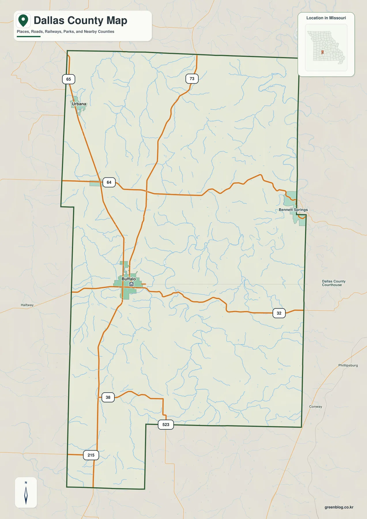
Dallas County sits in the Ozark interior of southwestern Missouri, with Buffalo serving as the clearest map reference and a dense network of creek valleys cutting through the countryside. U.S. 65 runs from the Urbana area through Buffalo and continues south, while Route 32 crosses the county eastward. The map set on this page combines roads and places with waterways and shaded relief, and the same four themes are available as high-resolution JPG files in a single downloadable ZIP for printing or offline use.
The county outline is broad across the north and center but narrows into a distinctive southwestern extension. Urbana and Louisburg occupy the northwestern side, Buffalo lies farther south, and Bennett Springs is labeled close to the eastern boundary. Hickory, Polk, Webster, Camden, Laclede, and Greene counties appear around the outside of the boundary, giving useful regional context that a county-only outline would not provide.
Table of Contents
Buffalo as the road and place-name anchor
Buffalo is the most useful starting point on the general map. The Dallas County Courthouse is marked in town, U.S. 65 passes through the area, and Route 32 heads east toward the county line. To the north, U.S. 65 leads toward Louisburg and Urbana. South of Buffalo, the same highway continues toward the narrower lower portion of the county, where Route 38 and Route 215 provide additional orientation.
Farther north, Route 64 crosses the county from west to east, while the Route 73 shield marks a north-south corridor through the northern interior. These roads make the map useful for comparing communities that may look close in a straight line but sit on different road approaches. It is a reference map rather than a live navigation product, so current driving time, construction, or closures should be checked with an up-to-date road service.
A three-place connection from Buffalo to Urbana and Louisburg
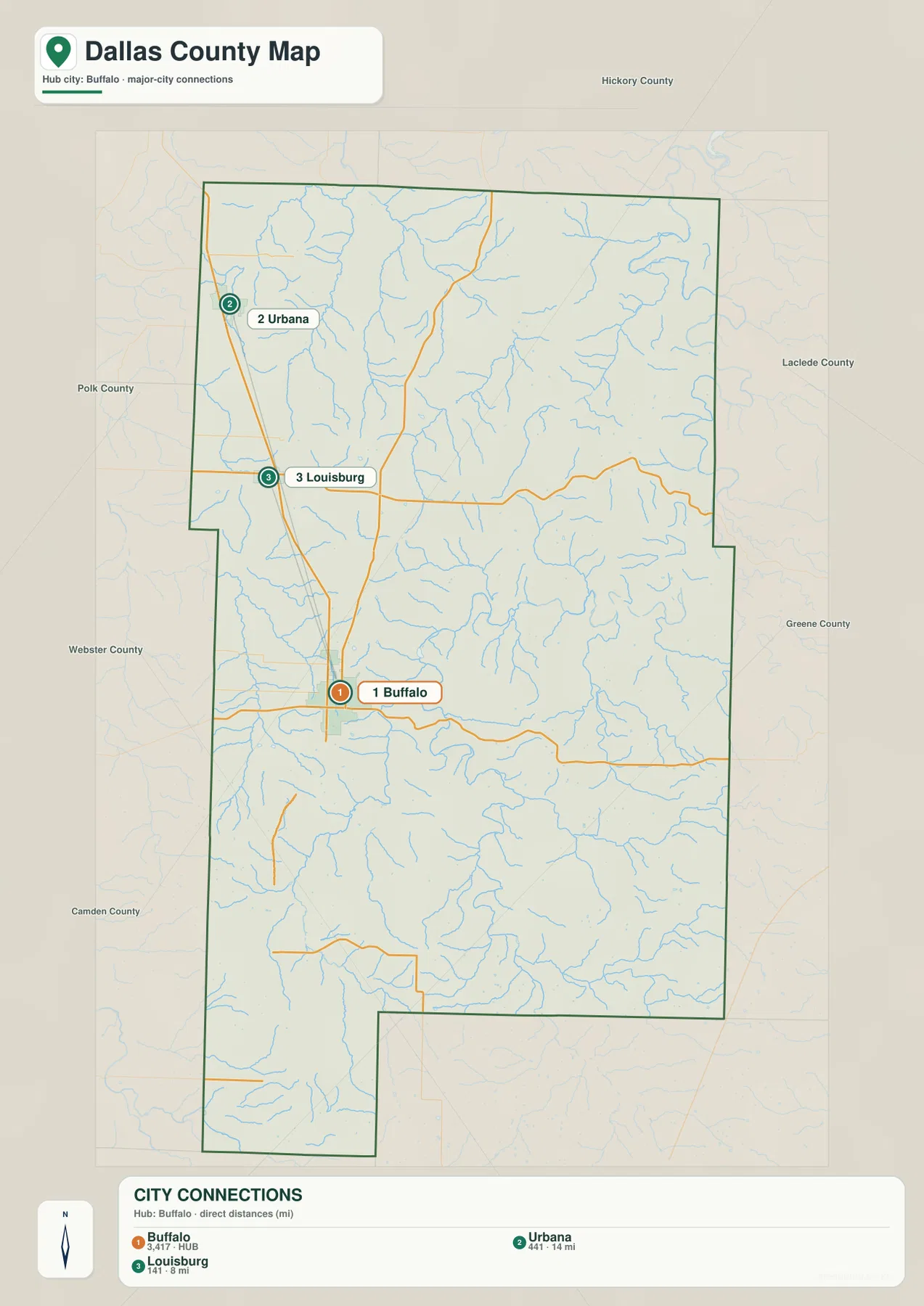
The city-connection map is deliberately simpler than the general county map. Buffalo is the hub and is labeled number 1, Urbana is number 2, and Louisburg is number 3. The graphic also prints a mapped population value of 3,417 for Buffalo. Urbana is shown about 14 miles from Buffalo and Louisburg about 8 miles away, but the legend identifies these as direct distances rather than road mileage.
That distinction matters in a hilly county. U.S. 65 provides a strong northwestern line between the three places, but an actual drive follows the road network rather than the shortest geometric line. The connection map is therefore best used to understand relative placement: Urbana is farthest northwest, Louisburg lies between Urbana and Buffalo, and Buffalo occupies the more central-southern position where east-west Route 32 becomes important.
Little Niangua River across the northern hills
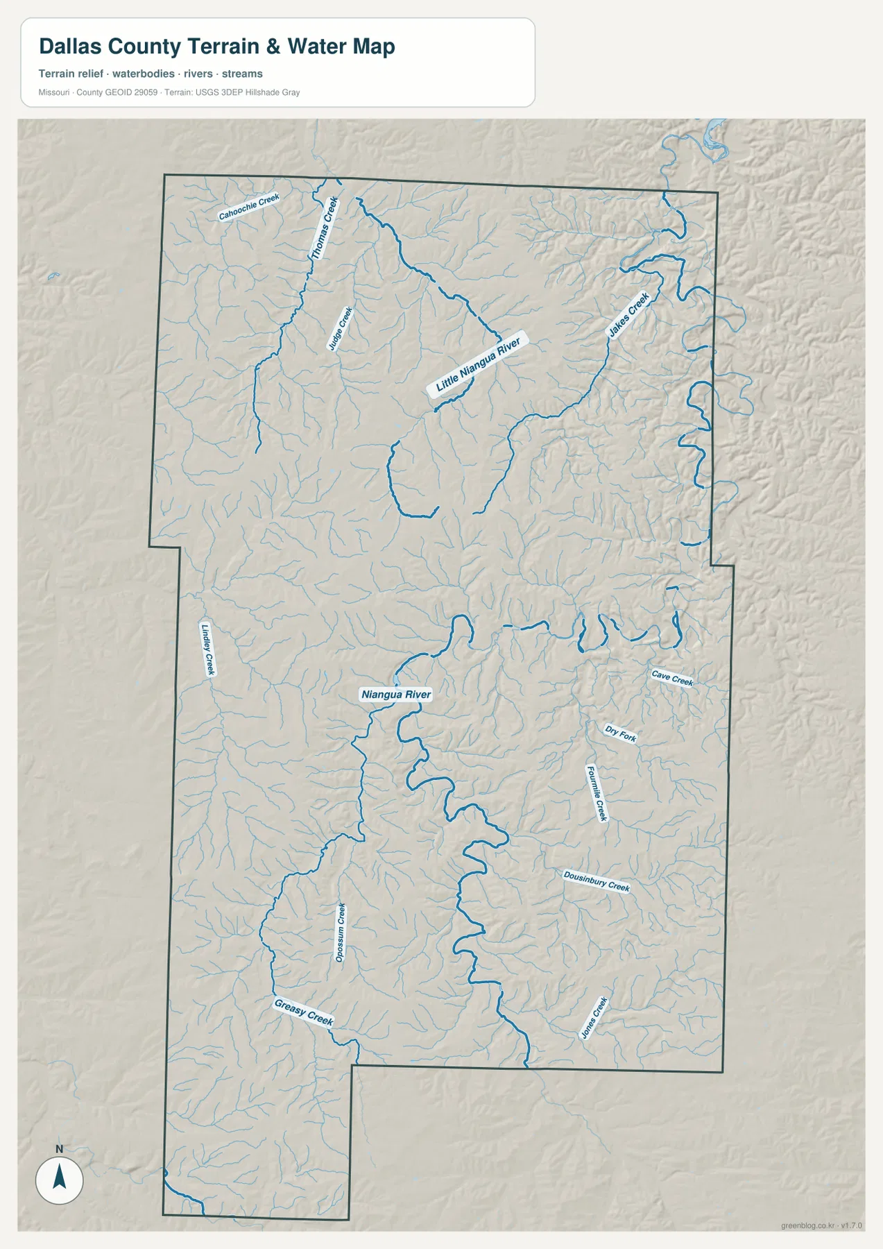
The northern half of the terrain-and-water map is organized around the Little Niangua River. It bends eastward through the upper part of Dallas County and receives a large number of short tributaries from the surrounding hills. Thomas Creek and Jakes Creek are among the named tributaries visible on the map. Their branching pattern shows why the northern landscape is broken into narrow ridges and valleys rather than one smooth upland surface.
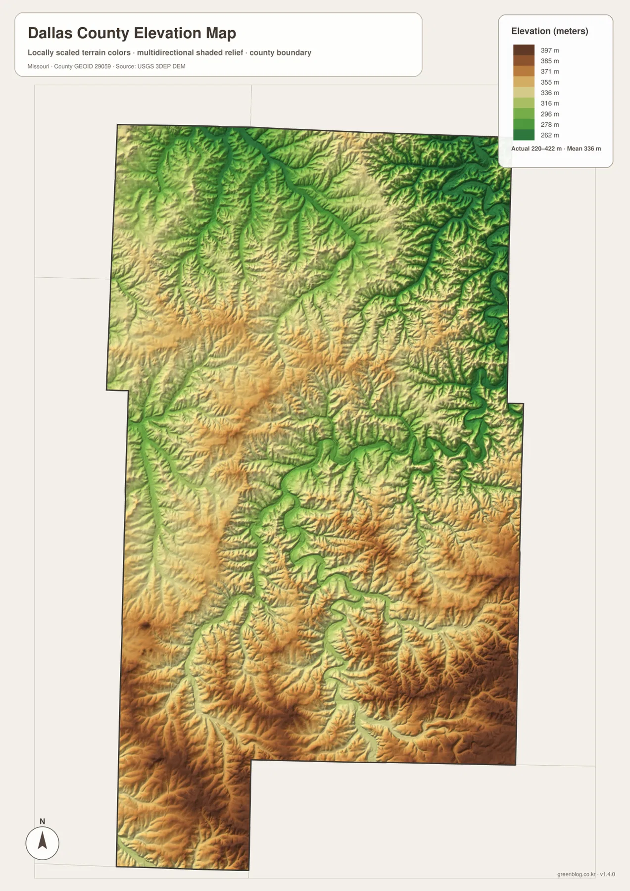
On the elevation layer, the Little Niangua corridor appears as a lower green band set between higher ridges. The northeastern edge contains especially tight, winding valleys, and smaller channels repeatedly cut across the slopes. Comparing this map with the road map also shows that Route 64 and other highways do not simply follow every stream valley; road lines sometimes cross several local drainage divides before reaching the next community.
Niangua River bends through the central and southern interior
South of the Little Niangua system, the Niangua River becomes the dominant water feature. It follows a long, sinuous valley through the central-southern part of the county. Cave Creek, Fourmile Creek, Dousinbury Creek, and Jones Creek are labeled on the eastern side, while Greasy Creek and Opossum Creek add detail farther west and southwest. The result is a dense drainage network that closely matches the dissected Ozark relief.
Buffalo itself is not drawn directly on the largest river bend, yet much of the surrounding rural area lies between tributary valleys. That relationship helps explain why straight-line distance can differ noticeably from road travel. The water layer is intended for geographic orientation, not flood forecasting or legal water-boundary decisions. For those uses, readers should consult current agency data and site-specific information.
Relief from 220 to 422 meters
The elevation map reports an actual range of roughly 220 to 422 meters and a mean near 336 meters. Higher ground is most prominent across the southern and southwestern parts of Dallas County, where brown tones cover broad ridges and steep-sided hills. Lower green terrain follows the major river valleys and many tributaries, creating long branching corridors that cut into the uplands.
The northern half is also rugged, especially around the Little Niangua River and the tightly spaced tributaries near the eastern side. The central and southern Niangua valley forms a clear low strip through otherwise higher ground. Because the color scale is designed to make local differences easy to see, this layer is appropriate for regional comparison rather than survey-grade elevation work or engineering measurements.
The eastern edge near Bennett Springs
Bennett Springs is labeled close to the eastern county boundary on the general map and provides a useful reference for the Laclede County side of Dallas County. From Buffalo, Route 32 runs eastward toward this side of the map. The label also helps distinguish the long eastern boundary from the shorter southwest extension, where the county outline steps inward before continuing south.
Surrounding county names reinforce that regional position. Hickory County is to the north, Polk County to the west, Webster County to the southwest, Camden County along part of the southwest, and Laclede and Greene counties to the east and southeast. Reading those names together with the main highways makes Dallas County easier to place within the broader Missouri road network without needing a separate statewide map.
Choosing the map that fits the question
For a first look, the general map is the best place to find Buffalo, U.S. 65, Route 32, and the county boundary. The city-connection version is more focused: it strips away most labels so the relationship among Buffalo, Urbana, and Louisburg is immediately visible. Readers interested in rivers should switch to the terrain-and-water layer, while the elevation image is most useful for comparing the high southern ridges with the lower Niangua and Little Niangua valleys.
Using the maps together is more informative than treating them as four unrelated images. A reader can locate Urbana on the road map, see its position relative to Buffalo on the connection map, then move to the water and elevation layers to understand the surrounding valleys and ridges. Because all four use the same Dallas County boundary, the transition between views is straightforward even when the visible labels differ.
County references beyond the map
The Missouri Association of Counties lists Dallas County offices in Buffalo, reinforcing the town’s administrative role. University of Missouri Extension also maintains its Dallas County office in Buffalo and provides county-level resources and annual reports. Those local references complement the map by connecting the visible place names with current public institutions in the county.
For source geography, U.S. Census Bureau TIGER/Line data are a standard reference for county boundaries and roads. The USGS National Hydrography program provides river and stream information, and the USGS 3D Elevation Program provides the elevation framework used for terrain work. These source systems are preferable when a task requires precise GIS data, while the maps on this page are intended as reader-friendly reference images.
Frequently Asked Questions
What is the best starting point on a Dallas County Missouri map?
Buffalo is the easiest anchor because it sits near the central-southern part of the county, is marked with the Dallas County Courthouse, and lies on U.S. 65 and Route 32. From Buffalo, the directions to Urbana, Louisburg, the eastern boundary, and the southern hills are easy to compare.
Are the 8-mile and 14-mile city-connection labels driving distances?
No. The city map identifies them as direct distances from Buffalo: about 8 miles to Louisburg and about 14 miles to Urbana. Road mileage can be longer because vehicles must follow the highway network through hilly terrain.
What stands out most on the Dallas County elevation map?
The strongest contrast is between the higher southern and southwestern Ozark ridges and the lower valleys along the Niangua and Little Niangua river systems. The mapped elevation range is about 220–422 meters, with a mean near 336 meters.
Map File Information
Download the map files associated with this page for reference, printing, and compatible visual projects.
- Included Files: Use only the versions confirmed in the article and supplied images
- File Type: Use the confirmed download contents
- Intended Use: Printing, education, presentations, and map-based projects
Related Maps
Sources and references
- Missouri Association of Counties – Dallas County – current county office information in Buffalo
- University of Missouri Extension – Dallas County – county office and local resources
- U.S. Census Bureau TIGER/Line Shapefiles – county boundaries and roads
- USGS National Hydrography – river and stream data
- USGS 3D Elevation Program – elevation data
Green Map creates custom-edited map images using open geographic data sources such as geoBoundaries, Natural Earth, OpenStreetMap, and government open data. These maps are edited visual materials, not raw data files, and are provided for education, documents, presentations, and graphic reference.